Jared Smith founded @chswx on Twitter in 2008 as an experiment in disseminating weather data through social media. In the ensuing decade-and-a-half, @chswx has provided live coverage of tropical cyclones, tornadoes, severe weather, and even a couple bouts of winter weather to the good people of Charleston, SC.
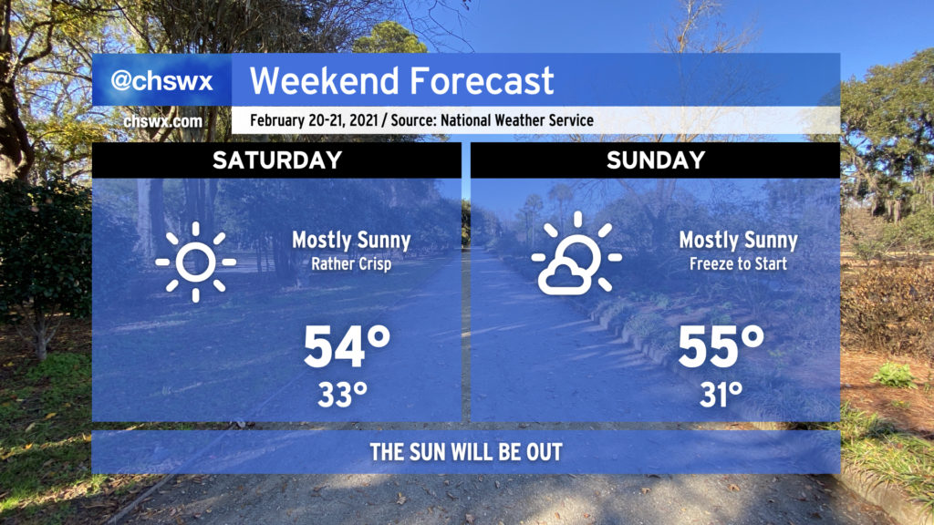
High pressure will assert control of the weather through the weekend. It’ll be chilly out — highs in the low to mid-50s and lows around or below freezing will be common — but the sun will be shining, and that alone is worth celebrating. Have a great weekend, everyone.
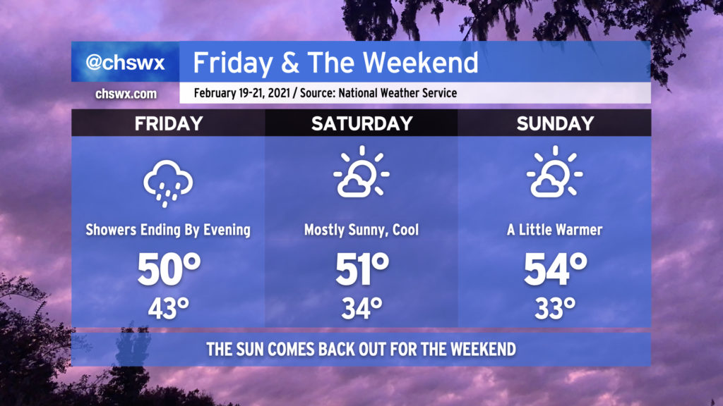
We have a chilly but mostly sunny weekend ahead. Now all we have to do is just hang in there through Friday as showers taper off throughout the day as the cold front slowly moves through the area and gets offshore. Temperatures will remain pretty chilly — only expect highs to top out around 50° tomorrow as the front moves by and cooler air begins filtering in.
Skies will clear Friday evening and overnight, and by Saturday, expect mostly sunny skies with high temperatures peaking around 50° as chilly high pressure moves over the region. Clear skies overnight Saturday should allow temperatures to drop to the low-to-mid-30s by Sunday morning, with freezing temperatures possible inland from the coast. The airmass will modify a little bit Sunday, and highs should warm into the mid-50s under mostly sunny skies.
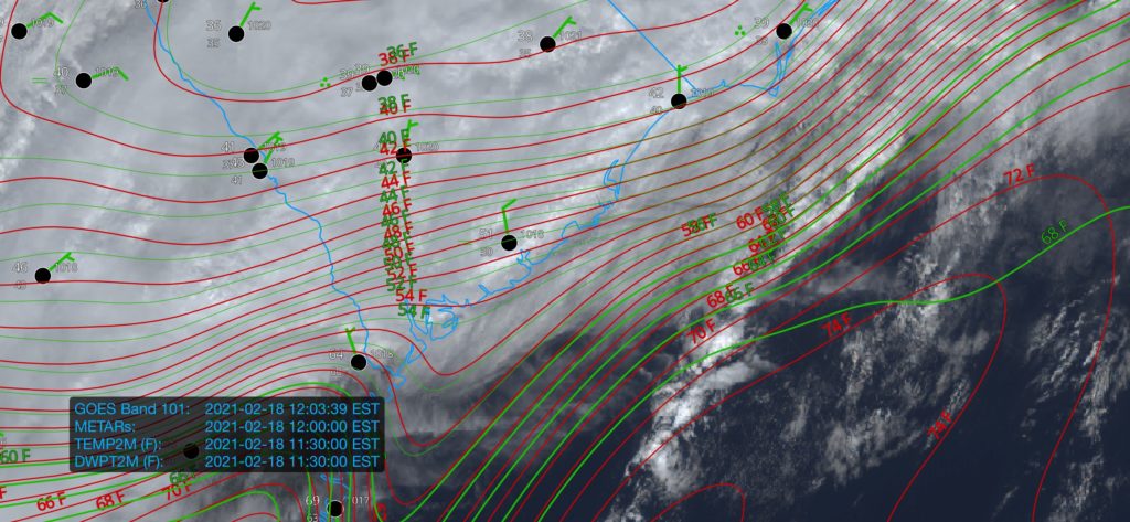
We’re once again in the gloom with periods of heavy rain moving through the area this afternoon. This is good, though, as these clouds and rain are reinforcing the inland cold air damming wedge which, in turn, is keeping a warm front from advancing too far north into the Lowcountry. All this to say that the severe weather threat, which was never terribly high in the Charleston metro to begin with, remains rather marginal. If the warm front does sneak a little further north than projected, the risk for damaging wind gusts would come up some. The best risk for any severe storms today remains southwest of us in Georgia.
The main issue today, especially inland of 17-A, will be the potential for flooding in spots. Some areas have already received 2-3” of rain in the I-95 corridor with more to come through tomorrow. Closer to the coast, the forecast continues to call for 1-2” through tomorrow with locally higher amounts.
As always, I’ve got an eye on it. Keep an ear out in case conditions change quickly, but so far, so good.
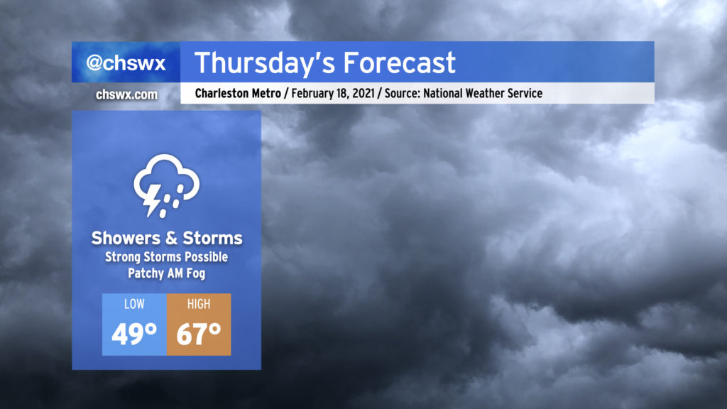
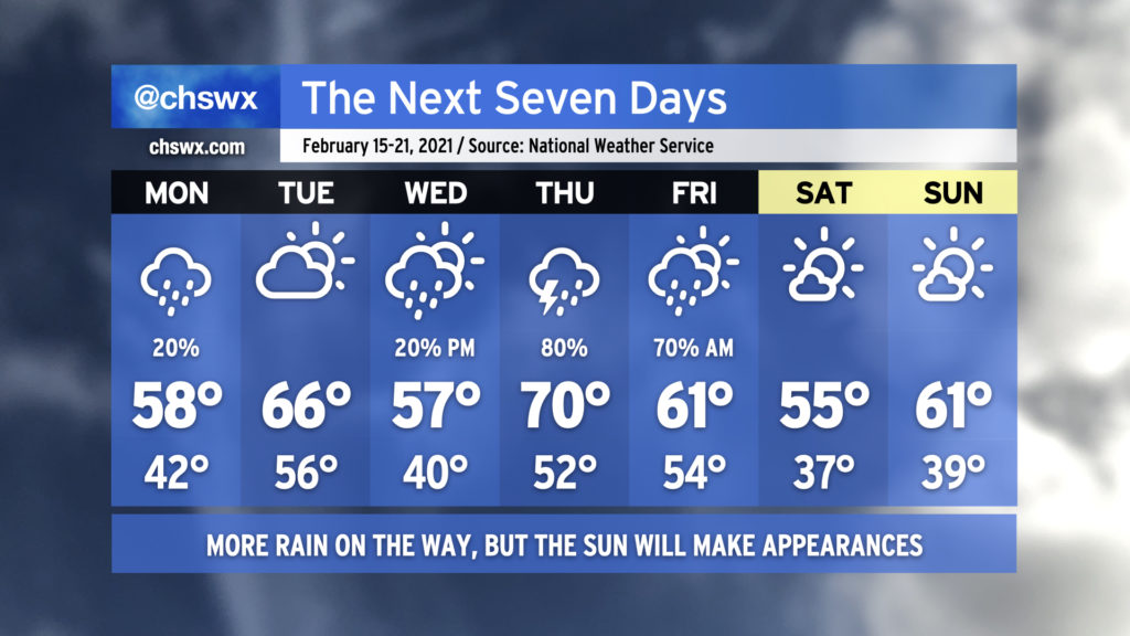
We’re back into the rain on Thursday as another storm system affects the area. Expect periods of showers and storms at any time throughout the day, and be ready for the potential for a couple storms to be strong.
I hope everyone enjoyed the outbreak of sunshine today! It was nice to see temperatures rebound into the mid-60s across the area with nearly cloudless skies for much of the day.
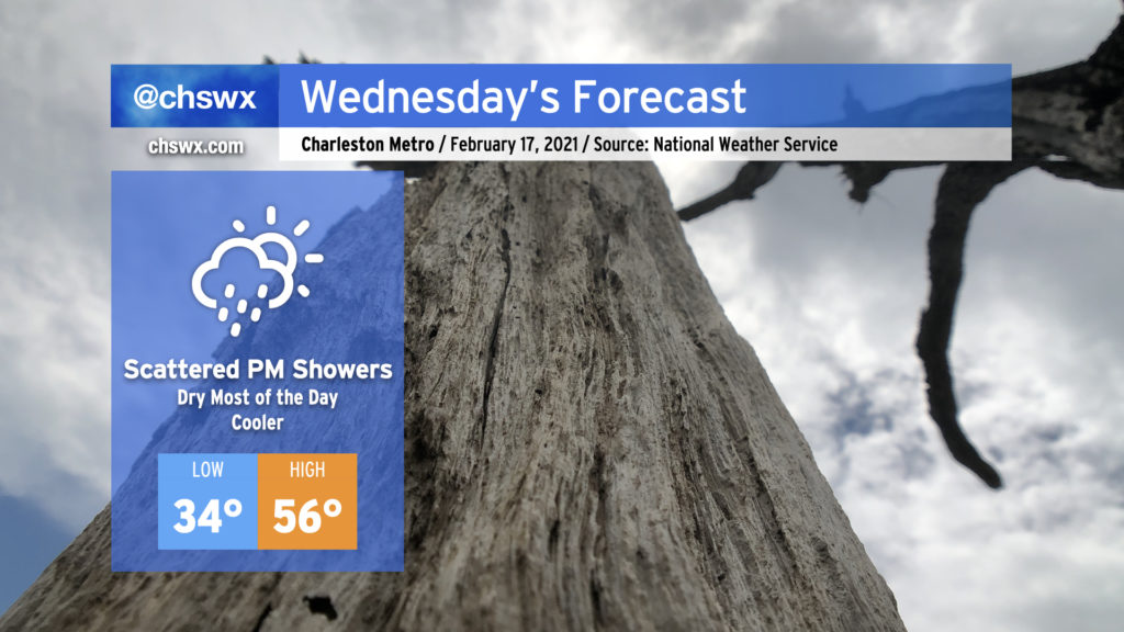
Unfortunately, our unsettled weather pattern remains in place, and today’s respite will be short-lived as clouds build back into the area during the day Wednesday, with shower chances increasing after sunset.
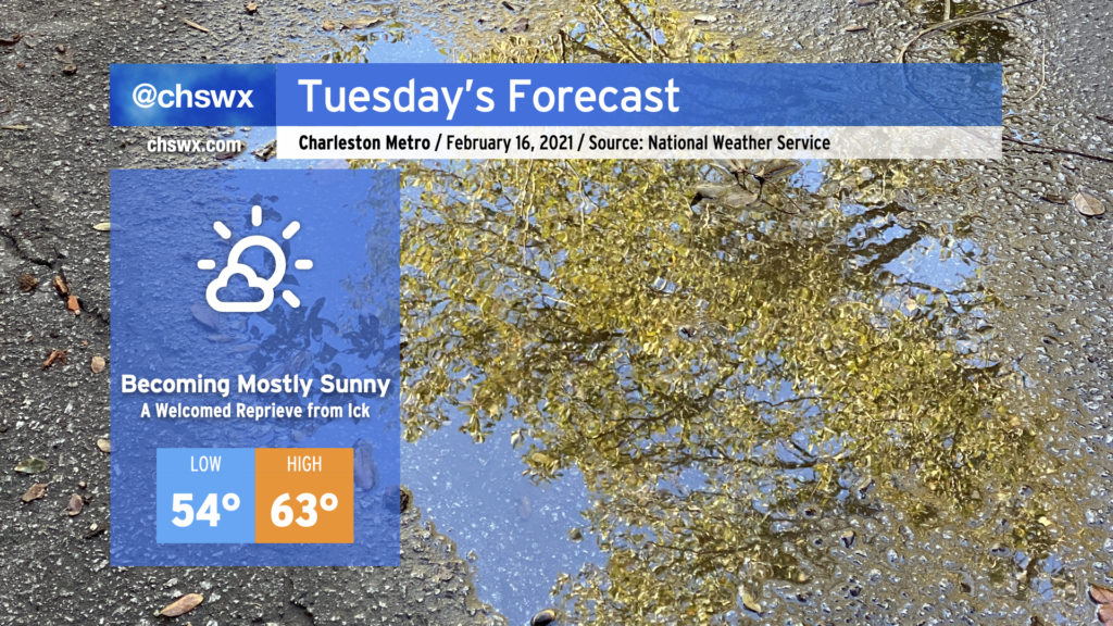
After a stormy Monday night caps off a rather dreary weekend, Tuesday is looking a lot better with at least a brief reprieve from the rain. Clouds will be scouring out in the wake of the front swinging through, and we should be mostly sunny by afternoon. Temperatures will rise quite nicely into the low 60s, which will feel downright blazing compared to the low 40s we found ourselves stuck in over the weekend. Unfortunately, this reprieve will be short-lived as rain chances return to the forecast Wednesday. We’ll take it a day at a time, though, and enjoy tomorrow!
It’s been quite a soggy weekend, with rain totals in many spots exceeding 1″ just today as seemingly relentless moisture pushed atop a cold air damming wedge, keeping the weather wet and chilly as temperatures have barely left the low 40s over the past two days.
Well, the good news is that things are changing, and that we will even see the sun at times this week! (The weekend looks good, too!) But, there will be more unsettled weather before it’s all said and done.
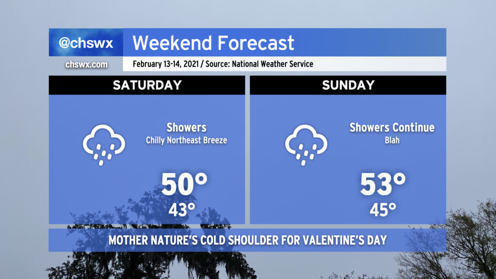
A cold air damming regime will remain in place over the weekend, with plentiful moisture and upper-level energy keeping numerous showers in the forecast along with chilly temperatures. This rain will be no joke — NWS is forecasting 1-3″ across the area by Monday morning, with the higher rain totals generally to be found inland of 17. The wedge of cold air nestled between the Appalachians and the Atlantic and its associated persistent overcast will keep temperatures well below normal (62° is the normal high for this time of year).
Despite what some weather apps were showing this time last week, no precipitation type issues are in the forecast this weekend as the core of the coldest air remains well to our north and west.
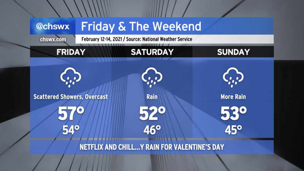
Unsettled weather will continue for Friday and into Valentine’s weekend as the overall pattern remains quite…well, gross.
We start Friday out with dense fog blanketing coastal areas and some showers in the area. (Use those low beams.) Showers will be off and on throughout the day. Temperatures are not going to move a whole heck of a lot overall as high pressure wedges down into South Carolina and Georgia, setting up cold air damming that will characterize much of the rest of the weekend’s weather. The forecast high of 57° at the Charleston airport should be realized fairly early in the day before the wedge front slides through.
Moisture overrunning the cold air damming wedge will keep clouds and rain in the forecast for much of the weekend. It’s unlikely that it will rain all the time, but it could rain at any time. Temperatures will run several degrees below normal beneath the cold wedge, but while it will feel chilly, temperatures will remain far too warm for any precipitation type issues here in the Lowcountry.
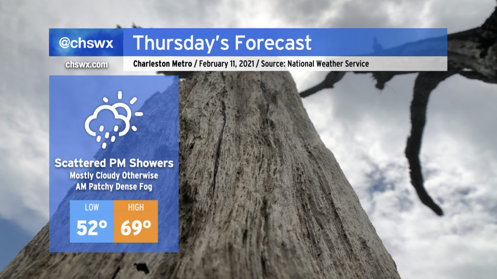
Watch out for fog Thursday morning as you commute — it could turn dense at times, so you’ll want to ensure you’re using the low beams and allowing a little extra time to get where you need to go.
After the fog clears up, we’ll still see mostly cloudy skies, but we could see a few peeks of sun at times. Regardless, temperatures look to warm to near 70° in the afternoon ahead of a cold front. Rain chances will increase as the day goes on, but don’t expect much in the way of widespread rainfall until after dark.