Jared Smith founded @chswx on Twitter in 2008 as an experiment in disseminating weather data through social media. In the ensuing decade-and-a-half, @chswx has provided live coverage of tropical cyclones, tornadoes, severe weather, and even a couple bouts of winter weather to the good people of Charleston, SC.
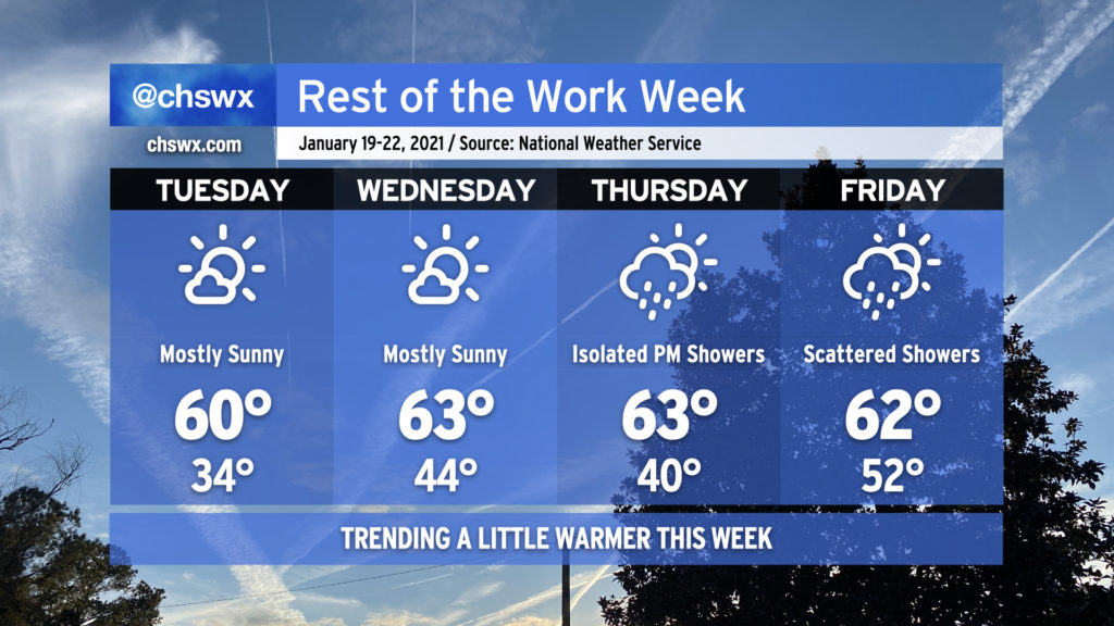
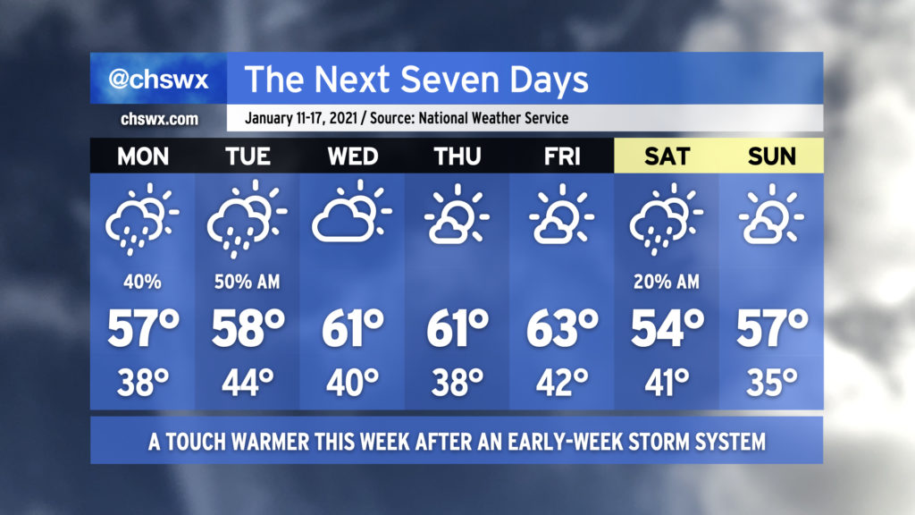
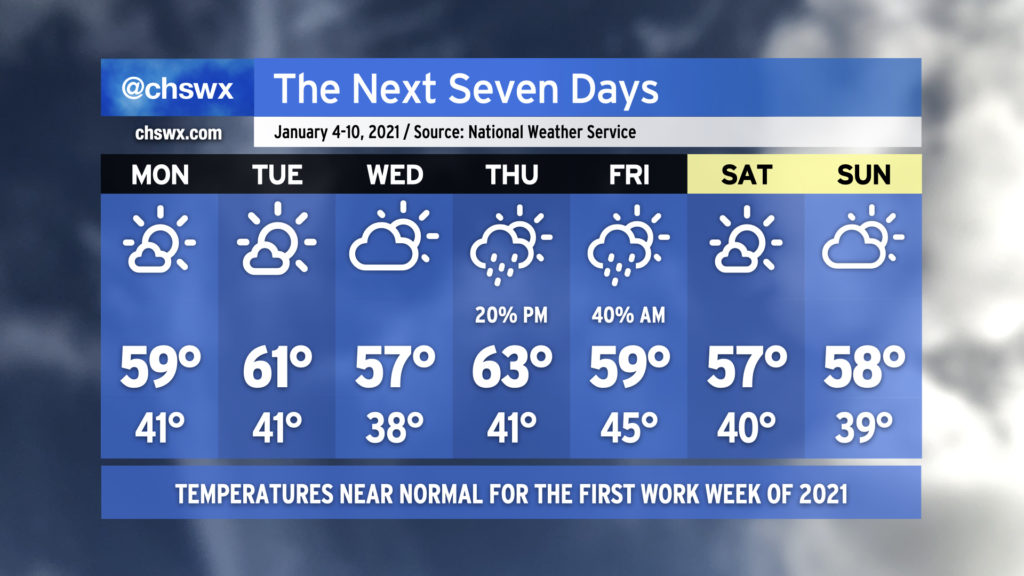
The rest of the work week will be characterized by a bit of a warming trend. Expect high temperatures in the low 60s from Tuesday through the end of the week before a cold front backdoors into the area sometime Friday.
Mostly sunny skies will dominate Tuesday and Wednesday before the next storm system begins to affect the area Thursday with increasing clouds and a slight chance of a shower late. Scattered showers will remain in the forecast on Friday as the front sags southward across the area.
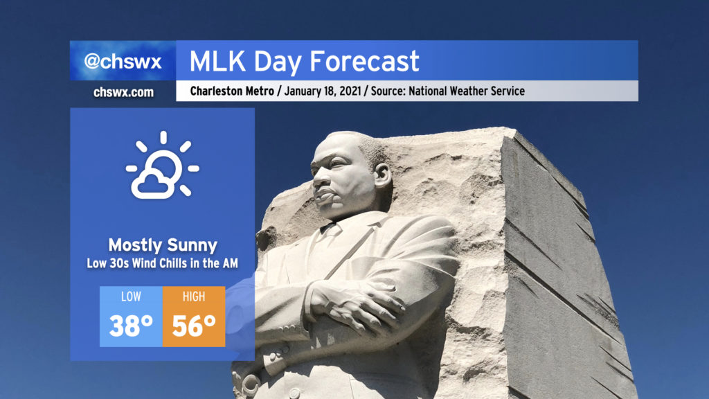
No weather concerns for Monday as we pause to reflect on the life and message of Martin Luther King, Jr. High temperatures will top out in the mid-50s — a click or two under January normals — despite mostly sunny skies with high pressure firmly in place. This year is certainly going to be very different with virtual events due to the ongoing pandemic, but any virtual events being held outdoors will probably have more trouble with Wi-Fi than weather.
We look to remain rain-free until at least Thursday when low pressure and its associated cold front approach from the west. Ahead of the front, we’ll be in a warming trend, with highs getting into the 60s by Wednesday. I’ll have more on the rest of the work week’s forecast in tomorrow night’s post.
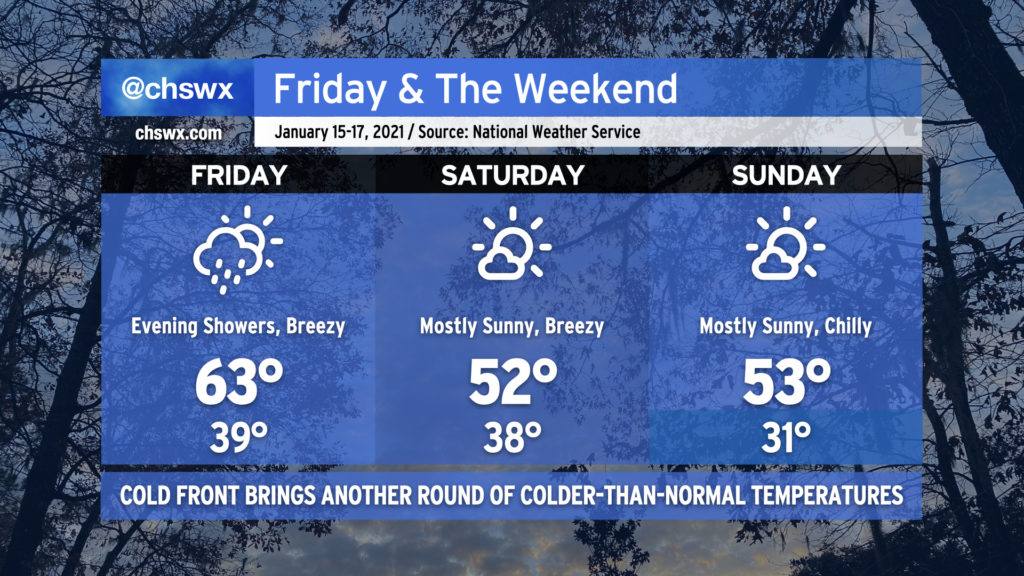
Clouds and eventually showers will return to the weather picture during the day tomorrow as a cold front approaches the area. Temperatures will get to the low to mid-60s before the front swings through. Winds will also kick up with the frontal passage, so be ready for gusts near 30 MPH through Saturday.
Speaking of Saturday, clouds will be clearing the area, but we will once again turn chilly, with highs only topping out in the low 50s. The aforementioned wind will make it feel even colder, too. Most of us away from the coast will see freezing temperatures Sunday morning (along with mid-20s wind chills). Highs will once again only reach the low 50s in the afternoon despite plentiful sunshine. These temperatures will be the result of a large cold-core upper low that will be swinging through the upper Midwest into the Ohio Valley and eventually New England over the weekend, sending a plunge of rather chilly air all the way south into Florida.
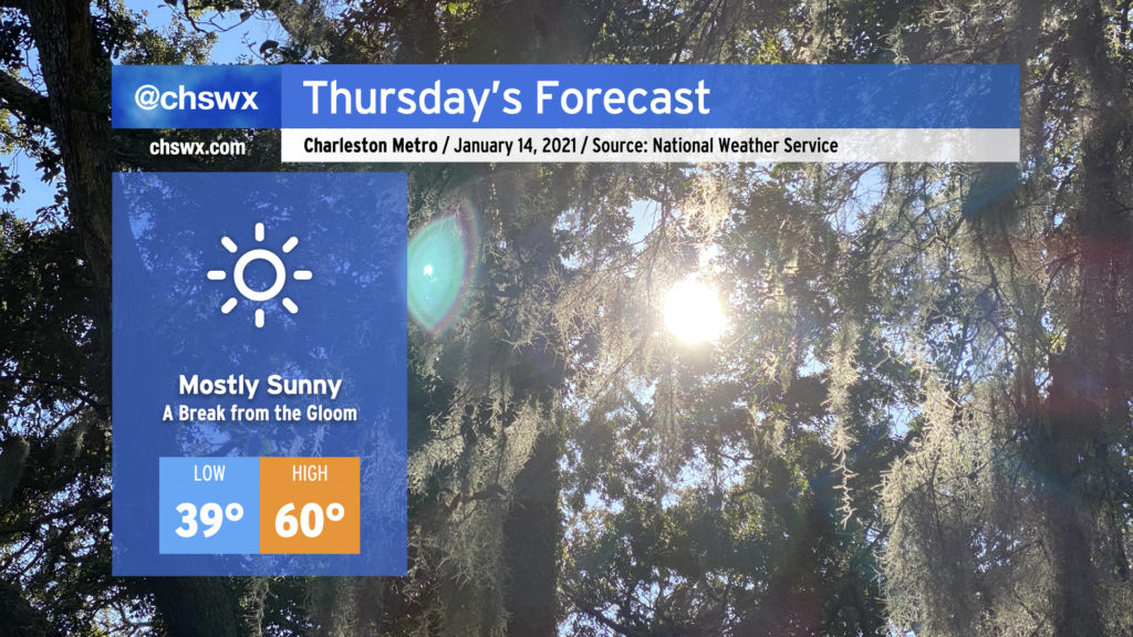
After a stubborn cloud deck kept temperatures significantly lower than expected today, we will finally get these clouds out of here once and for all and enjoy a mostly sunny day on Thursday. Highs will top out around 60° in most spots. It’ll sure feel nice to get this gloomy stuff out of here, that’s for sure.
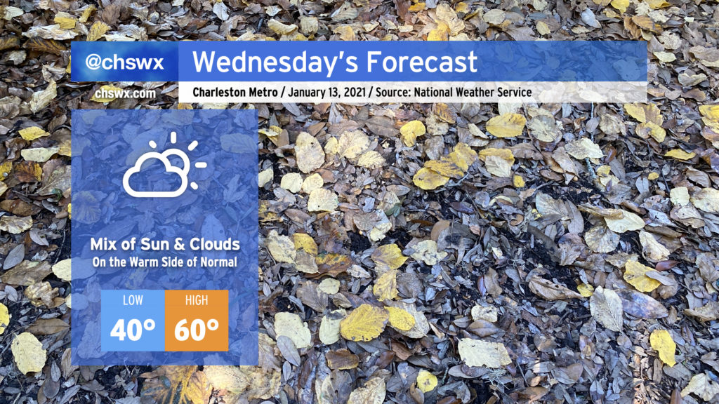
We’ll warm up a bit on Wednesday as a little more sun works into the area with high pressure at the surface. Cloud cover will be reinforced at times by some upper-level energy moving through the area, but despite that, we should touch 60° in the afternoon, which is right on the warm side of a normal high temperature for mid-January.
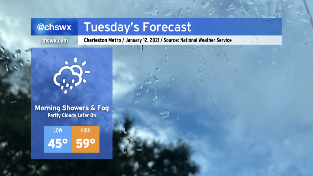
Watch for patches of fog in the morning causing dips in visibility at times. Fog should mix out by 9am, giving way to the aforementioned partly sunny skies.
As low pressure moves eastward along the Gulf coast, we’ll keep the risk of showers and drizzle around through early Tuesday afternoon before high pressure begins to build in and cloud cover slowly breaks. Watch for areas of fog in the morning; be sure to use low beams and be prepared for visibility to drop quickly.
We should see a little sun before Tuesday’s gone, and there will be much more where that comes from as we get into the rest of the week. Temperatures could top out in the upper 50s, but this certainly will be dependent on how quickly the cloud deck can scour out.
The week ahead will be characterized with a few showers to start before warming up and clearing out in the second half. Clouds will increase overnight into Monday, with showers potentially developing over the ocean and moving inland starting in the afternoon. Shower chances will continue into Tuesday as a wave of low pressure affects the area. Once the disturbance clears the area, we’ve got a few nice days to close out the work week, with temperatures topping out in the low 60s each afternoon. A cold front will swing through early Saturday that may bring a shower or two, but other than that, we’ll cool back to around or a little below normal for the weekend.
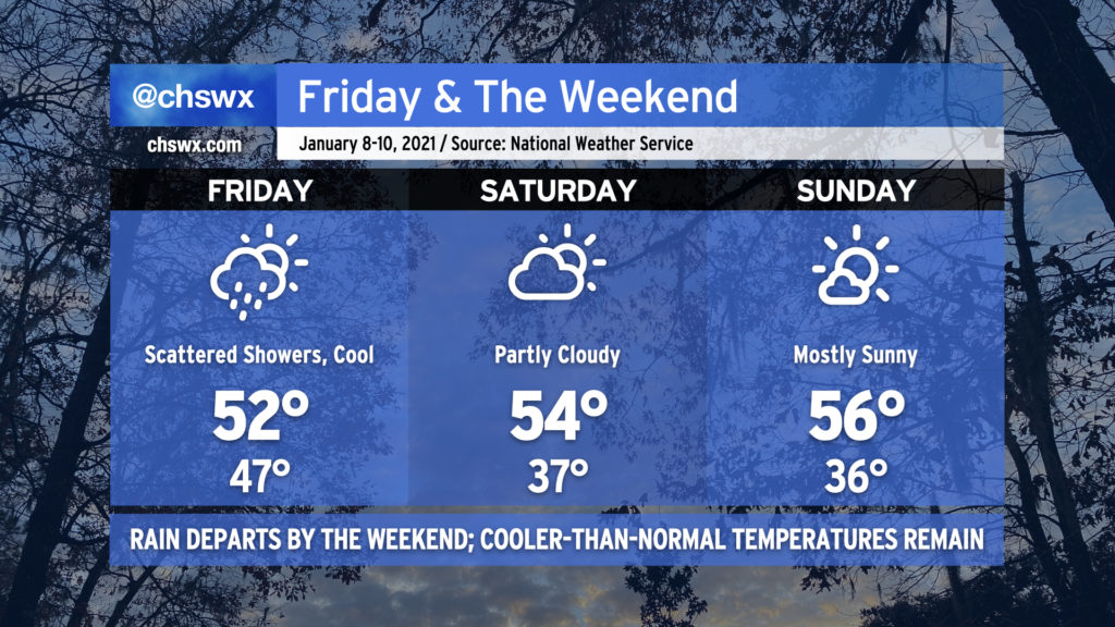
We have a cool and quiet weekend ahead in the Lowcountry. Tonight’s rain will exit the area early Friday morning as a cold front swings through the area, but the storm system’s parent upper low will continue to lumber through North Carolina, potentially spawning scattered showers as the day goes on in our neck of the woods. Rain chances will decrease even further after sunset Friday, leading to a dry weekend.
Temperatures will remain cooler than January normals throughout the weekend, with mid-50s the norm as we sit between the departing low pressure system and high pressure in the upper Midwest. Relatively dry air will keep cloud cover generally thin, especially on Sunday.
Our next storm system arrives Monday as another upper low ushers through a front to start the week.
The first work week of 2021 will generally arrive with little weather fanfare, with temperatures at or slightly above early January normals for much of the week. Rain chances tick up Thursday into Friday as a storm system moves through, but quiet weather returns for the weekend.
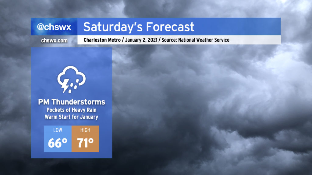
Well, 2021 is definitely getting off to a muggy start. After tying the daily record high of 80° for January 1, we’ll start Saturday in the mid-60s — several degrees above the normal high temperature — as unusually muggy air persists ahead of a cold front. Expect showers and perhaps a thunderstorm or two to develop by afternoon, which will temper highs a bit (but not before reaching the low 70s). Some pockets of heavy rain are possible within stronger thunderstorms, but no severe weather is anticipated and the flood threat remains low. When all is said and done, some spots may have picked up 1-2″ of rainfall.
The front will get a move-on during the day, though, and by Sunday morning should be clearing the area, leaving behind quiet and generally pleasant January weather with slightly above-normal temperatures for the first work week of 2021.