Spring’s last gasp?

Today we find ourselves between two fronts: one that will be pushing off the coast (but perhaps not before kicking off a shower or storm or two) and another that will provide what may very well be Spring’s last gasp.
Read more »Today we find ourselves between two fronts: one that will be pushing off the coast (but perhaps not before kicking off a shower or storm or two) and another that will provide what may very well be Spring’s last gasp.
Read more »
We will need to keep an eye on the weather this weekend as a couple rounds of strong to severe storms will be possible, particularly Sunday, as the upper-level ridge which has been squelching a lot of thunderstorm activity slides offshore.
Read more »
We’ve got another dry and seasonably warm spring day ahead. Temperatures will top out in the low 80s under partly cloudy skies; onshore flow will aid the seabreeze in punching through the area this afternoon, which will keep temperatures in check. A shower or two can’t be totally ruled out along and ahead of the seabreeze this afternoon, mainly inland from the coast.

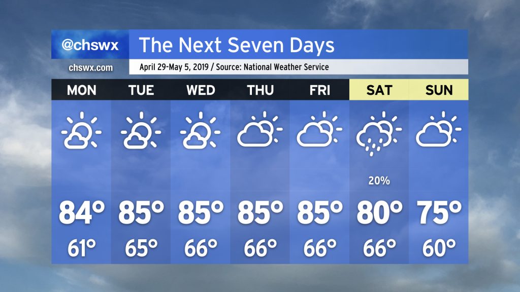
Drought continues over the Lowcountry as we head into the first full week of May. Some of you got some decent rainfall this weekend, but for many of us, just a few showers fell. (I got a grand total of 0.05″ on Saturday and Sunday, the first measurable rainfall since April 20.) Moderate drought conditions continue, with mostly dry weather (save for the potential for a thunderstorm this afternoon) expected through Wednesday.
Since the Good Friday severe weather event, weather has been largely quiet in the Charleston metro area. Even a front that swung through this past Friday wasn’t able to eke out any rain across the Lowcountry. As a ridge of upper-level high pressure continues to be in control, we have more warm, dry days ahead.
Read more »
The warmest stretch of 2019 (thus far, anyway) continues today as high pressure slips a little further offshore. Highs in the upper 80s will be commonplace away from the immediate coast. If mid-week beach days are your thing, today definitely qualifies.
Read more »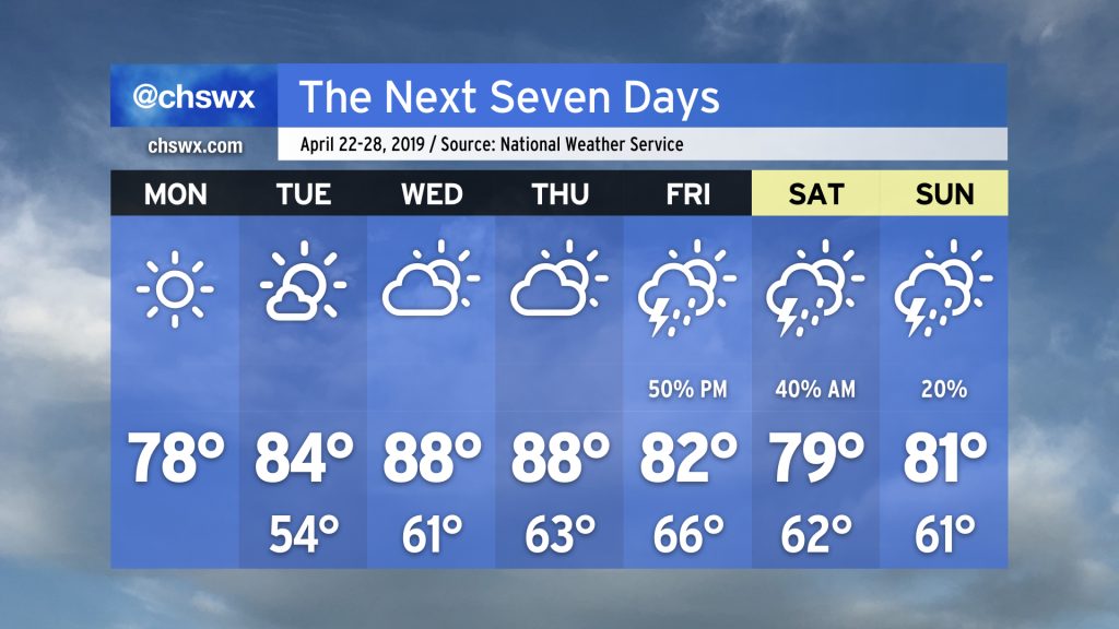
High pressure remains in control of the forecast through Thursday, yielding several quiet weather days. (That sound you hear is the collective sigh of lots of Charleston-area meteorologists who spent much of Friday doing battle with spin-up tornadoes.)
We’ll maintain seasonable conditions through Tuesday as high pressure gradually slips offshore. Southerly flow around the back side of the high turns on the heat pump for Wednesday and Thursday, with highs expected to top out in the upper 80s for the first time this year. A cold front will then approach on Friday, bringing a chance for showers and thunderstorms to the area. Some chance of rain lingers through the weekend, but it’s nothing to toss your plans over.

Straight-line winds were the order of the day for the Charleston area from an intense squall line that moved through the Southeast yesterday.
Read more »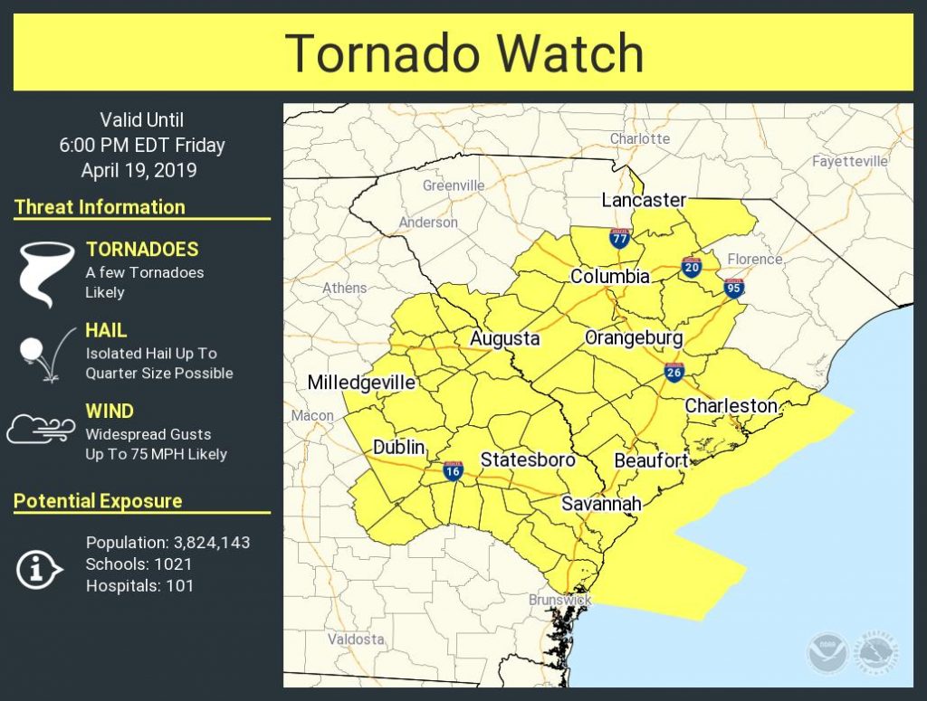
UPDATE: The tornado watch has been canceled.
Charleston is under the gun for potentially strong to severe thunderstorms today as a strong cold front, aided by vigorous winds aloft, approaches the area.
Expect a squall line with damaging wind gusts, isolated embedded tornadoes, and hail to come through the area later this afternoon into early evening. Timing for this event will be a little later in the afternoon; suspect anytime after 2PM will be tricky if thunderstorms do not erupt ahead of the line. This will almost certainly have impacts on the evening commute, particularly for those of you trying to get a head start on Easter travel.
Read more »
Friday is an important day to watch in the weather department as there is good model agreement that a storm system will be affecting the area during the day, driving a squall line into the area by afternoon. Gusty winds, hail, coastal flooding, heavy rain, and perhaps even a tornado will be possible. Let’s take a look at some of the issues we may encounter.
Read more »