Jared Smith founded @chswx on Twitter in 2008 as an experiment in disseminating weather data through social media. In the ensuing decade-and-a-half, @chswx has provided live coverage of tropical cyclones, tornadoes, severe weather, and even a couple bouts of winter weather to the good people of Charleston, SC.
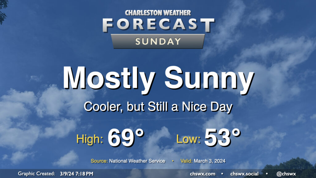
After the cold front that helped instigate quite a busy morning of weather gets offshore, we end up with a rather nice Sunday as cloud cover clears out, leaving mostly sunny skies in its wake. Temperatures will start in the low 50s and warm to the upper 60s to around 70° in the afternoon. The only fly in the ointment will be the breeze: expect gusty conditions throughout the day as high pressure builds in, with winds 10-15 MPH perhaps gusting to 25-30 MPH at times.
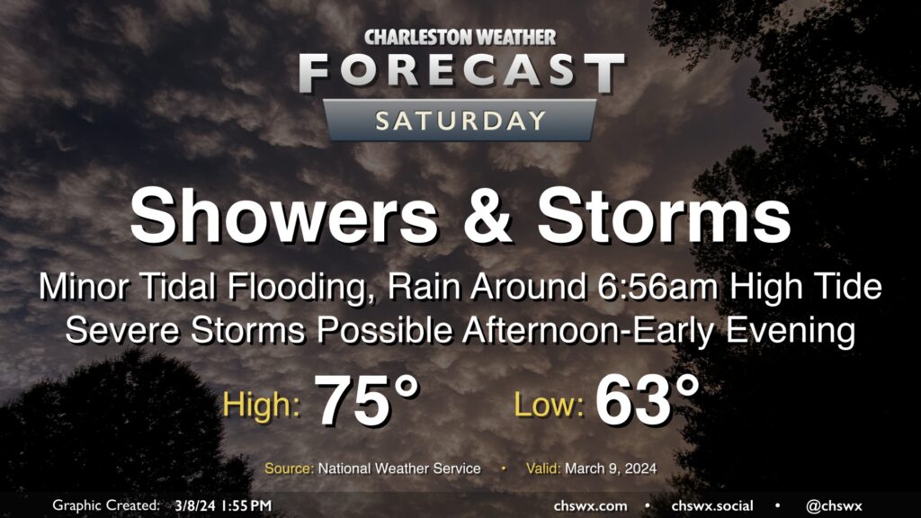
After one round of thunderstorms moved through Wednesday, a second round of unsettled weather, featuring potentially flooding rains in the morning and severe thunderstorms in the afternoon, lies ahead on Saturday.
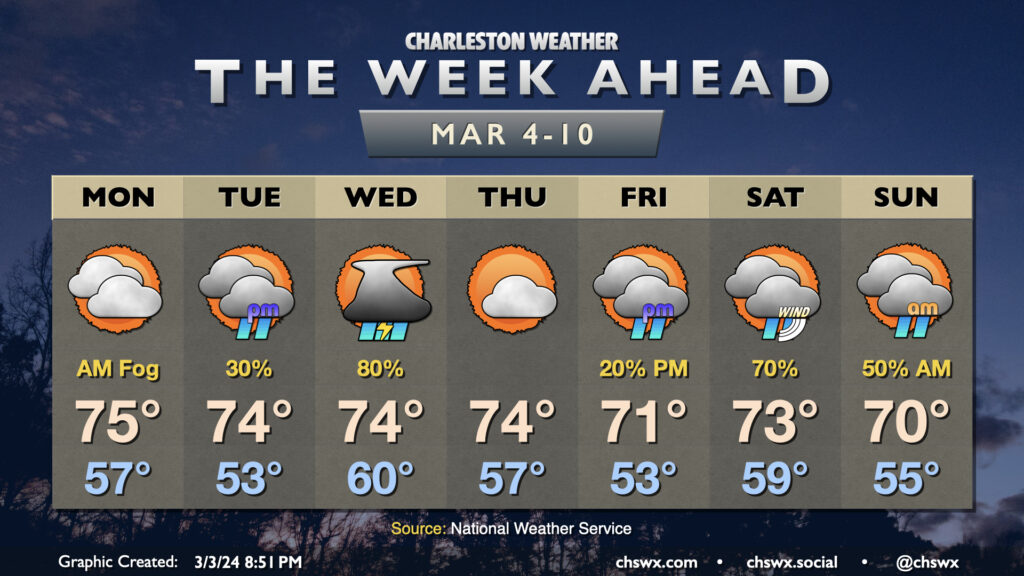
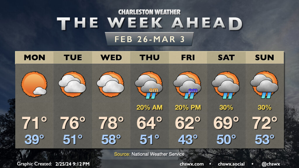
Well, it will certainly feel like climatological spring this week as we stay on the warm side of normal for early March with a couple storm systems dropping through at times. First, though, we’ll get off to another potentially foggy start Monday morning as lows dip to the mid-50s. Fog should dissipate by mid-morning, and we’re looking at another warm day in the mid-70s under a mix of sun and clouds as high pressure asserts itself a bit more.
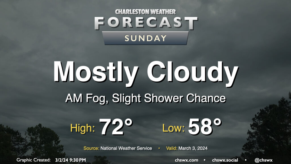
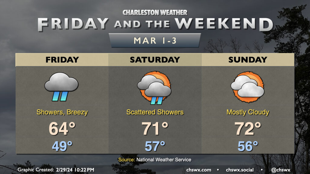
Clouds will continue to hang around on Sunday with the specter of a shower or two remaining in the forecast. We’ll likely start the day with patches of potentially dense fog at times, so be ready for low visibility in the morning. The fog’s expected to mix out shortly after daybreak, leaving behind generally overcast to mostly cloudy skies for the remainder of the day. It’ll be a warm start, with temperatures in the upper 50s yielding to highs in the low 70s in the afternoon. As mentioned, a few showers are possible, but it’s quite possible that much of us get the day in rain-free. Still not a terrible idea to keep rain gear handy, though, just in case.
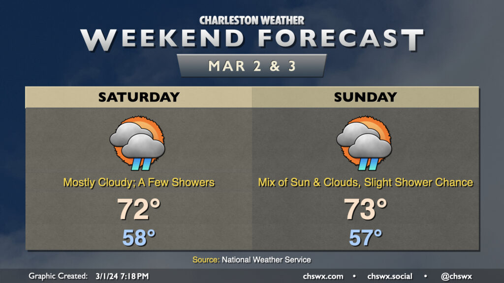
Surface low pressure will have pulled well away from the Lowcountry by Saturday morning, but we don’t get completely off the hook for rain chances this weekend with a lingering front and a warm airmass. Temperatures will run well above normal — we start the day in the upper 50s, warming to the low 70s in the afternoon. Cloud cover will feature prominently, and as mentioned, there is the risk for a few showers from time to time, but we should have a decent amount of rain-free time as well.
Sunday will be similar as the front continues to hang around. We’ll start the day in the mid-to-upper 50s once again, warming to the low 70s with sun peeking through cloud cover occasionally. The risk for showers remains, though it will be a little lower than we saw on Saturday. Shower chances will quiet down for Sunday evening, leading to a dry Monday before shower and thunderstorm chances return to the forecast for Tuesday through much of the upcoming week.
We’ll get March — and climatological spring — off to a fairly wet start on Friday as moisture overruns the area throughout the day. We start the day within range of normal — generally the upper 40s — but only warm to the mid-60s in the afternoon as rain showers increase throughout the day. There could be some pockets of heavy rain at times, particularly depending on the positioning of a developing low pressure system, but right now the risk for the heaviest rain looks to stay offshore. Still, it’ll be a day for the rain gear as rain looks to continue well into Friday night.
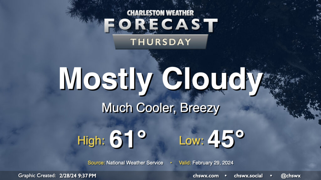
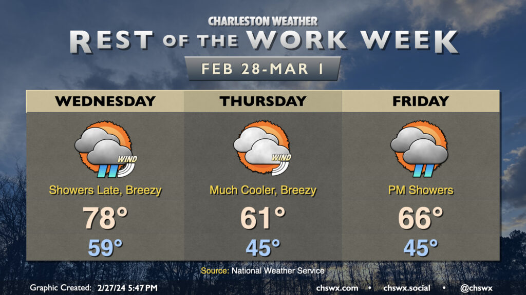
We’ll wake up to much cooler air on Leap Day as a cold front will be long-gone by Thursday morning. Temperatures will start in the mid-40s, warming only to the low 60s at best as high pressure wedges into the area. We’ll get some peeks of sun at times, but the mid-and-high cloud deck will prove formidable. It’ll be a breezy day as well, especially in the early going. By evening, we will start to see more in the way of low-level moisture return to the area, which could bring a few showers late Thursday.
Unseasonable warmth continues for one more day before it is blunted by a sharp cold front that will bring a few late showers Wednesday followed by much cooler weather on Thursday.
First, though, we start Wednesday with low temperatures approaching 60°, warming to the upper 70s to maybe even 80° in the afternoon ahead of the aforementioned front. It’ll be breezy, too, as the pressure gradient tightens ahead of the front. We should stay rain-free through the daylight hours; from there, a thin line of showers, which has been depicted on models for the past several days, should move by and produce a little rain, but nothing too impactful.
The impacts from the front will come in the form of a sharp cooldown for Leap Day. We start Thursday in the mid-40s, only warming to the low 60s in the afternoon with more clouds than not and breezy northeasterly winds. Winds will slacken a little bit Thursday night into early Friday, though low pressure developing offshore as high pressure wedges southwestward into the area should help to tighten the gradient a bit more as we go through Friday. Shower chances increase throughout the day Friday as moisture overruns the wedge and the aforementioned low pressure develops, with rain chances peaking Friday night into Saturday morning. Temperatures are currently forecast in the mid-60s, but downward revisions to that forecast certainly seem possible as we learn more about the strength of the wedge.
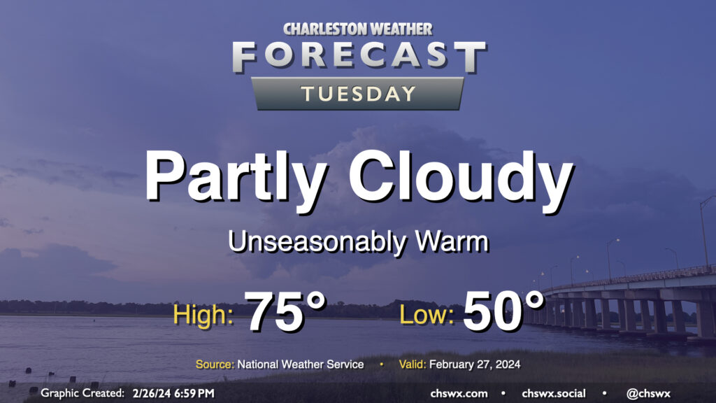
We turn even warmer on Tuesday as high pressure moves further offshore and more warmer air is drawn northward. Temperatures start several degrees above normal, generally in the low 50s (and even warmer closer to the coast). From there, we’ll head well into the mid-70s in the afternoon despite an uptick in cloud cover compared to Monday as a disturbance moves by to the north. We’ll stay out of the rain, though. Winds will run a little on the breezy side as well, but nothing too crazy.
Sunday’s chill yields to a much warmer few days to start the new week and close out February. After a chilly start in the upper 30s, temperatures on Monday will rise into the low 70s, several degrees warmer than we reached on Sunday, thanks to plenty of sunshine and winds starting to go southerly as surface high pressure moves offshore. The warming trend continues for Tuesday and Wednesday, with lows in the low 50s on Tuesday yielding to highs in the mid-70s in the afternoon. Wednesday will start well above normal — think upper 50s — before temperatures make a run at 80° in the afternoon despite a mix of sun and clouds.