Jared Smith founded @chswx on Twitter in 2008 as an experiment in disseminating weather data through social media. In the ensuing decade-and-a-half, @chswx has provided live coverage of tropical cyclones, tornadoes, severe weather, and even a couple bouts of winter weather to the good people of Charleston, SC.
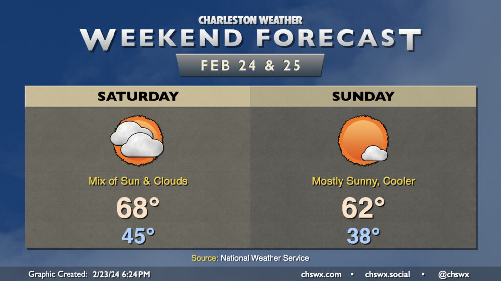
This weekend’s weather is generally looking quiet, with a fair bit of sunshine and temperatures generally a few degrees within normal. Saturday will run on the warm side of normal behind Friday night’s cold front, with lows bottoming out in the mid-40s before warming to near 70° in the afternoon. Another cold front will come through later Saturday accompanied by an uptick in cloud cover for most of us. A shower or two will be possible near the Santee, but other than that, the vast majority of us stay rain-free.
This front brings cooler-than-normal temperatures for Sunday, though not horrendously so: lows bottom out in the upper 30s with a slight north wind taking wind chills to the mid-30s. Sunshine looks to be more in abundance on Sunday than Saturday, and this will help temperatures head to the low-to-mid-60s in the afternoon. Temperatures rebound quickly into the 70s on Monday, with warming continuing through at least midweek as we put the finishing touches on another relatively warm climatological winter.
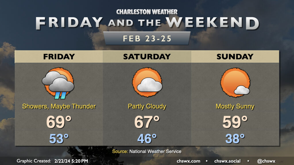
The first of two cold fronts to affect the area this weekend comes through on Friday, bringing showers to the area and maybe even a thunderstorm or two. It’ll be the warmest start to a day this week, with lows bottoming out only in the low 50s. Temperatures should warm to the upper 60s to around 70°, but the rain being around will make it decidedly less nice.
The first front clears the area in time for Saturday, which should be the warmer of the two weekend days. We start the day in the mid-40s while highs head to the mid-to-upper 60s once again under partly cloudy skies. Clouds will tick up as we head into Saturday afternoon and evening as the second front moves by, and there’s an outside shot at a shower or two as it moves through. This front will bring more of a cool shot of air to the area, with lows on Sunday bottoming out in the upper 30s and highs struggling to reach 60° under mostly sunny skies. The chill is short-lived, though: temperatures on Monday head into the upper 60s, while we’re well into the 70s by Tuesday as we close out February and climatological winter.
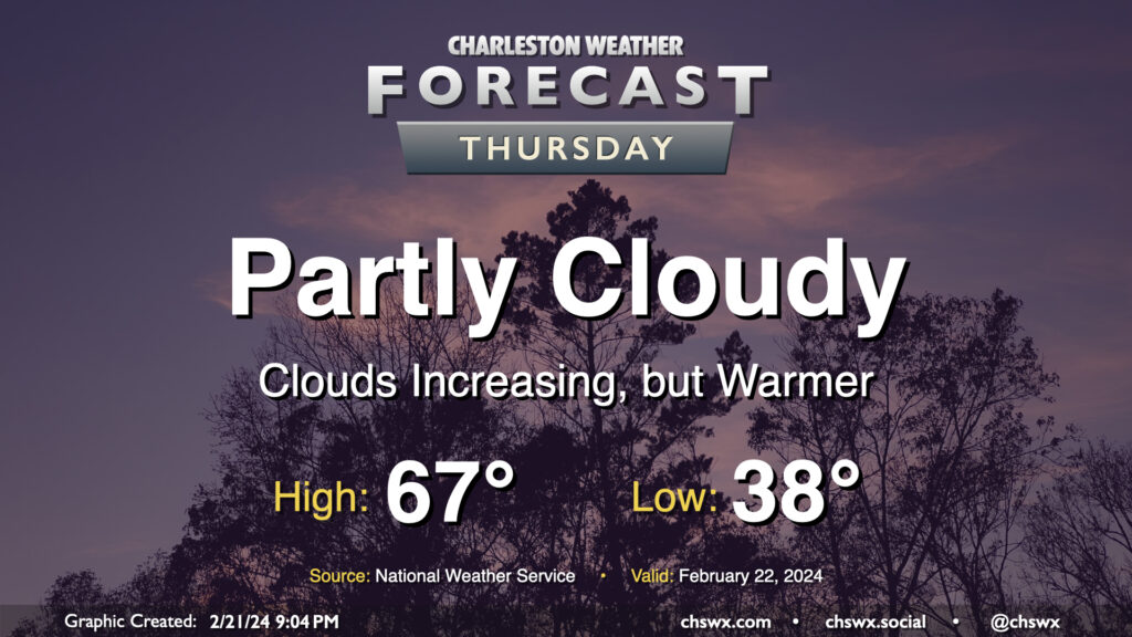
One more quiet day of weather lies ahead before a brief round of rain for Friday. Temperatures on Thursday start in the upper 30s — still running a little below normal for this point in February — but warm to the mid-to-upper 60s in the afternoon as southerly flow moderates the airmass a little bit more. We’ll start the day on the clear side, but clouds will gradually increase ahead of a cold front that’ll affect the area on Friday with the first shower chances in a few days.
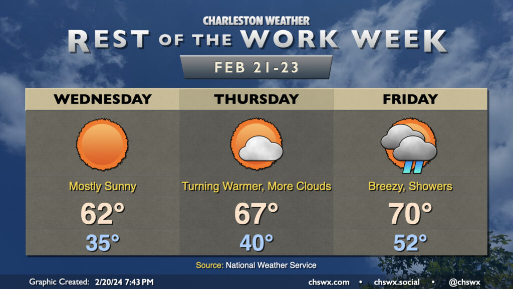
We have a couple more quiet days of weather ahead before showers associated with a cold front affect the area Friday. Wednesday will be another bright and sunny day with temperatures a few clicks below normal. We start the day in the mid-30s and warm to the low 60s as high pressure moves overhead.
From there, a warming trend develops ahead of the aforementioned Friday front. Thursday will start about 5° warmer as lows bottom out around 40°, while winds coming back out of the south help drive highs to the mid-to-upper 60s in the afternoon. Cloud cover will be increasing as the front draws closer throughout the day Thursday, but rain will hold off until at least Friday morning. Showers and maybe a thunderstorm will be possible during the day, but severe weather isn’t expected. Friday will be a spring-like day with lows in the low 50s yielding to highs around 70° in the afternoon, tempered by shower activity.
The front clears the area late Friday, and we will have a quiet weekend of weather with temperatures generally around late February normals (mid-60s highs) and lots of sunshine.
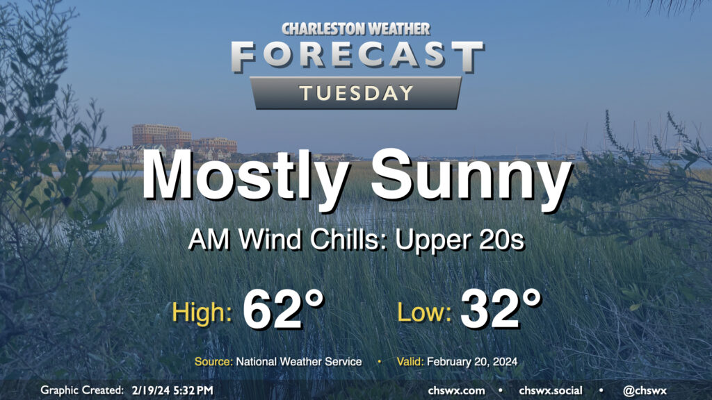
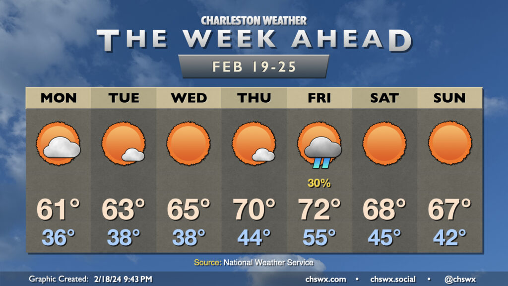
We have a chilly night ahead as clearing skies and light winds allow for good radiational cooling conditions. This should allow morning lows on Tuesday to reach freezing for the first time since January 22, when we started the day at a frigid 23°. It won’t be quite as cold — freezing temperatures in the metro would be relatively short-lived — but with some light wind in the morning, it’ll feel more like the upper 20s as we get back to regular order after Washington’s Birthday. There will be plenty of sunshine, though, and that’ll help counteract some cooler air continuing to filter into the area, allowing highs to top out in the low 60s once again.
After a fairly dreary weekend (and a particularly chilly Sunday), the sun returns for a majority of the upcoming week (with a good-looking weekend on tap, too, for a change). We will stay on the chilly side for a couple more days, though, with lows in the mid-30s greeting us on Monday. Cloud cover will come and go throughout the day as a disturbance moves across the area, but it’ll be too dry at the surface for any rain. Still, there should be enough sun to get us to the low 60s Monday afternoon.
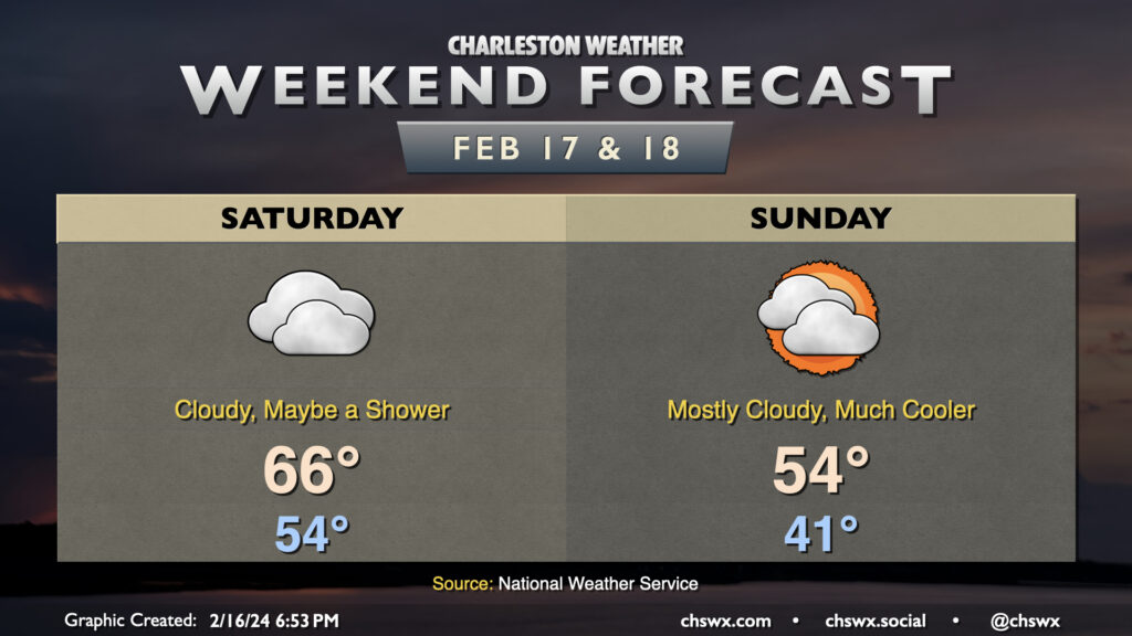
This latest stretch of 70°+ weather comes to an end Saturday as a cold front moves through the area. Dry air near the surface will preclude much, if any, rainfall from affecting the area as the front moves by, though a light shower or two can’t be totally discounted. We start the day in the mid-50s before warming to just the mid-60s in the afternoon as the front moves by and we start to cool off.
Clouds struggle to break up post-front on Sunday, but we should see at least a few peeks of sun. Still, it’ll turn much cooler — we start in the low 40s, but will only warm to the mid-50s at best with all the cloud cover around. This chill doesn’t hang around particularly long, though, as we’re back in the 60s on Monday and approaching 70° later next week.
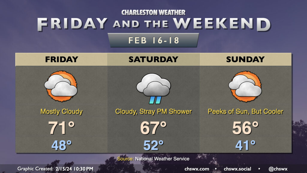
Friday & the weekend will feature more in the way of cloud cover, with a cold front bringing a brief cooldown to the area for Sunday. We’ve got one more day of 70s ahead on Friday, though, despite mostly cloudy skies as moisture increases ahead of the next storm system. Said storm system doesn’t amount to too much here, though, as it’ll primarily keep us overcast with a few stray showers possible on Saturday, but little else as the bulk of the low-level moisture stays to our south. Temperatures on Saturday start on the warm side thanks to the overcast, with lows only bottoming out in the low 50s before warming to the mid-60s in the afternoon. A cold front then sweeps through overnight, leaving us in the low 40s Sunday morning and only warming to about the mid-50s in the afternoon. There will be some peeks of sun through the cloud cover, but clearing in earnest will take place as we get into Monday.
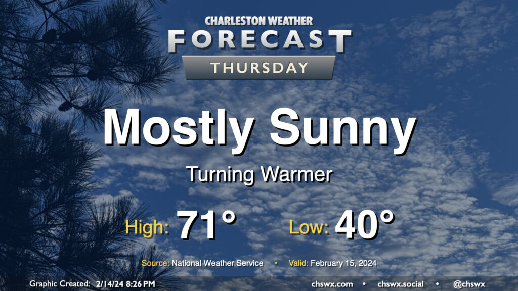
We got close to 70° on Wednesday, but we should reach it on Thursday with another day of mostly sunny skies under the influence of high pressure. We start the day around 40° and warm quickly to the upper 60s by midday, and will likely peak in the low 70s during the early part of the afternoon. Winds will shift to the southwest and will pick up a little in the afternoon, with speeds around 10 MPH becoming common later in the day.
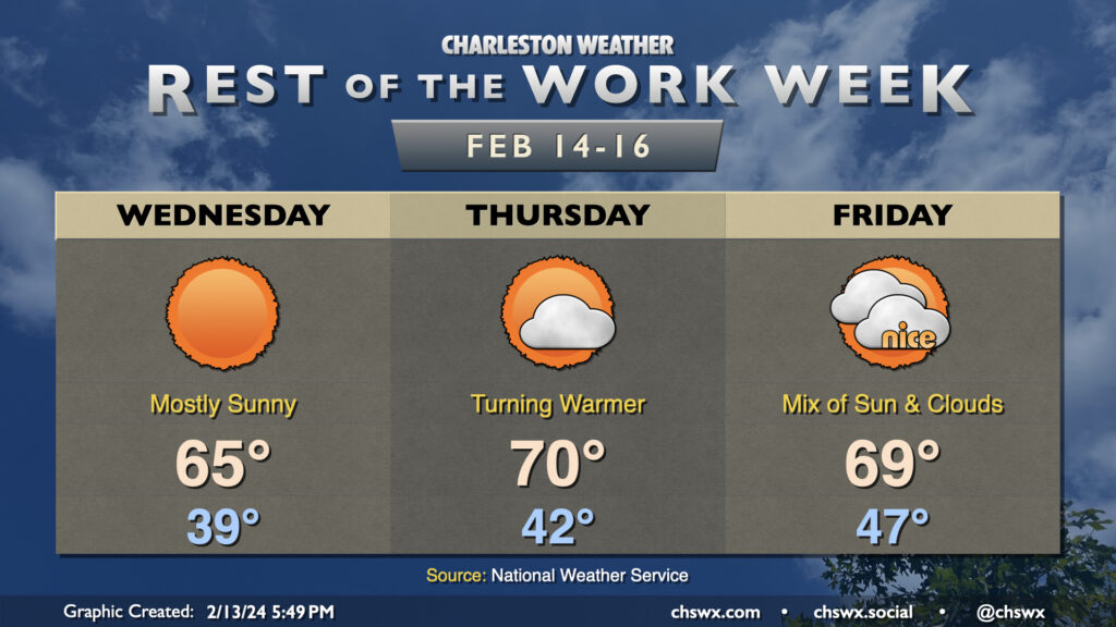
We’ve got quiet weather for the rest of the work week as high pressure remains in control through Friday. Wednesday will bring another round of nearly uninterrupted sunshine, but will also represent the coldest start to a day for the rest of the week with lows bottoming out in the upper 30s. The sun will help warm us up quite nicely into the mid-60s in the afternoon, a couple clicks above normal for Valentine’s Day.
We turn even warmer on Thursday, albeit with a little bit more in the way of clouds around. Thursday starts in the low 40s and warms to around 70° in the afternoon. A dry cold front will blunt the warming trend on Friday. We start the day in the upper 40s thanks to a little more cloud cover blanketing the area, but highs will be limited to the upper 60s to around 70° under mostly cloudy skies. Still, it should be a nice day.
The next rain chance arrives Saturday as low pressure moving toward the mid-Atlantic states drags a decidedly more wet cold front through the area. High pressure builds in behind it for Sunday, which will briefly cool us off before temperatures rebound to around and slightly above normal values by next Tuesday.