Jared Smith founded @chswx on Twitter in 2008 as an experiment in disseminating weather data through social media. In the ensuing decade-and-a-half, @chswx has provided live coverage of tropical cyclones, tornadoes, severe weather, and even a couple bouts of winter weather to the good people of Charleston, SC.
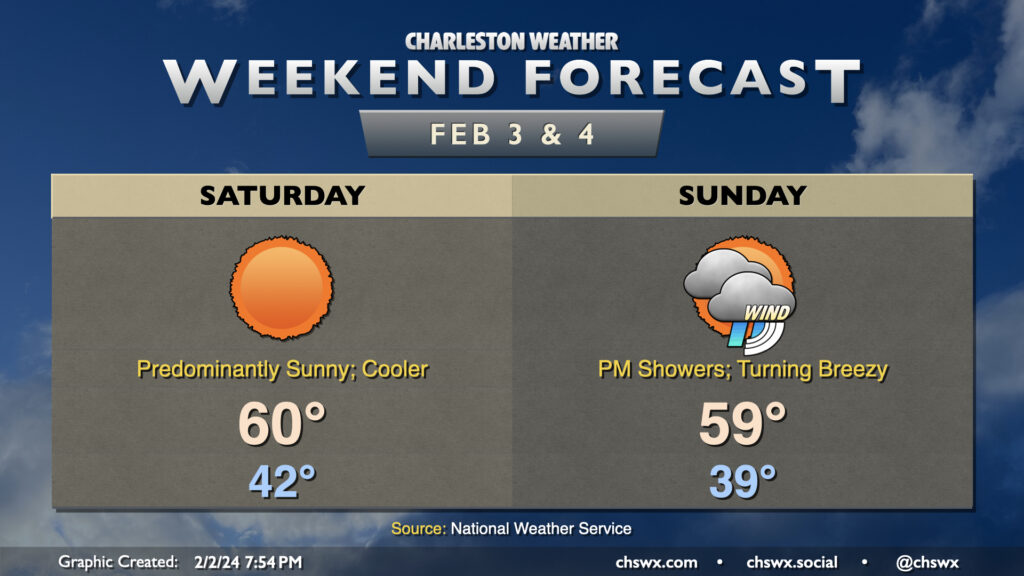
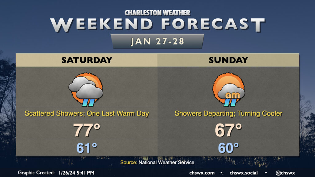
This stretch of quiet weather culminates in a sunny and a bit cooler day on Saturday. A front will come through overnight Friday into early Saturday morning, kicking up the winds a little and swinging them around to the northeast. Temperatures Saturday start in the low 40s, but will only warm to about 60° despite nearly cloudless skies during the day.
Sunday will be a different story. We’ll stay on the cool side with strengthening northeasterly winds throughout the day — expect highs to top out in the upper 50s to around 60° in the afternoon — but cloud cover will be on the increase as a storm system approaches from the west. Showers will advance on the area throughout the day, and we should start to see some showers by early afternoon. Rain will pick up later in the day and especially after sunset. As low pressure to the west and high pressure to the northeast continue to butt up against each other, the pressure gradient will pinch and winds will subsequently increase. We should see gusts to 30 MPH by sunset, and this will continue overnight as rain falls. The rain could be heavy overnight; by the time moisture shunts offshore during the day Monday, some spots could receive an inch and a half of rain with even higher amounts. There will even be a risk for some tidal flooding early Monday morning as well, but it should peak well before commute time. Keep an eye on forecast updates as the details become further refined.
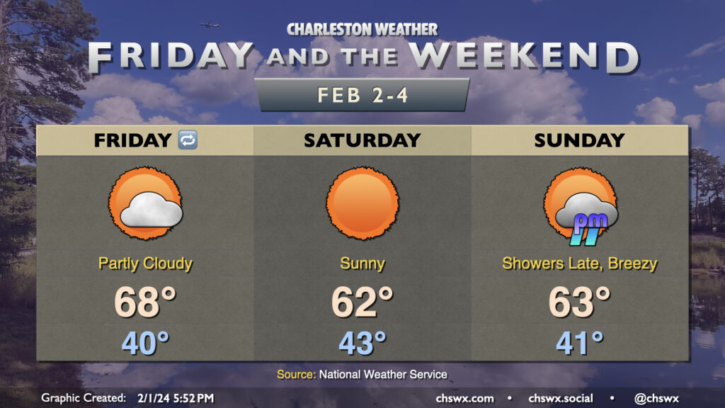
Friday and the weekend will be generally quiet, though we will be watching winds and clouds increase on Sunday ahead of a storm system that’ll make for a windy and soggy Monday. Friday starts around 40° and warms to the upper 60s under partly cloudy skies that will be turning clearer as the day goes on — a rather springlike day regardless of what the groundhog says. Saturday will run a little cooler as a dry front slides southward across the area, with highs topping out in the low 60s as winds turn more northeasterly. Still, skies will be pretty close to if not completely cloud-free, and it’ll be a comfortable day to get out and about.
We’ll start to see changes Sunday as low pressure moving eastward along the Gulf Coast starts to butt up against high pressure to our northeast. The gradient between these two features will tighten over the area, kicking northeasterly winds up throughout the day Sunday. The rain should hold off for much of the day, but we should start to see some showers affect the area late (probably after sunset). Highs on Sunday top out in the low 60s with the continued and strengthening onshore flow. This will lead into what could be a fairly windy and showery Monday, particularly in the morning as low pressure makes its closest approach. Forecast details are still coming together for Monday, so stay tuned for updates throughout the weekend.
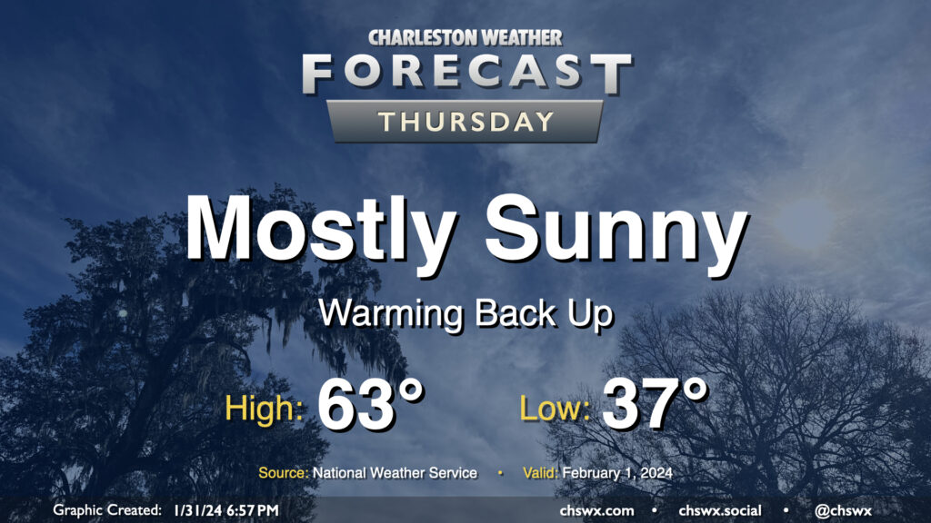
The sun comes back out on Thursday with the upper low long gone, and this leads to a nice warmup for Thursday. After starting the day in the mid-to-upper 30s, we’ll warm to the low-to-mid-60s for the start of February. Overall, no major weather concerns to kick off the month, and that ain’t bad.
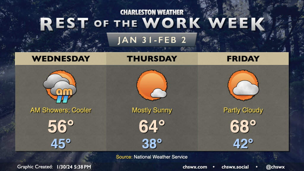
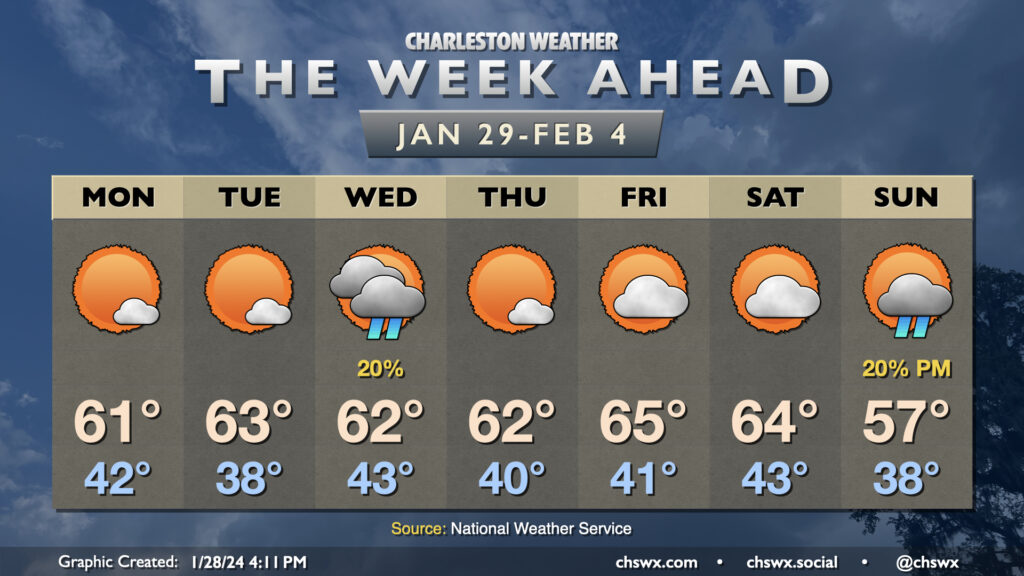
Generally quiet weather continues for the balance of the work week. The exception will be Wednesday morning, when a little bit of energy aloft traverses the area and squeezes out some shower activity. Rain gauges won’t catch much precipitation at all, and it should be out of here by afternoon. Clouds could hang around, though, and some cooler air blowing in behind the disturbance will keep highs pinned to the mid-50s Wednesday afternoon.
High pressure — and, as a result, sunshine — returns to close out the work week. Expect mostly sunny skies on Thursday. After a seasonably cool start in the upper 30s, highs will warm to the mid-60s in the afternoon. Friday is still looking good, too, with low 40s yielding to upper 60s in the afternoon under partly cloudy skies, so if we get stuck in a temporal loop, at least the weather will be nice.
Peeking ahead at the weekend, we see a quiet and seasonably warm Saturday but an increasingly unsettled Sunday as another storm system approaches the area. This storm system peaks overnight Sunday into Monday with decent rainfall expected. Rain chances diminish heading into next Tuesday, with a little bit of a chill in the air as well.
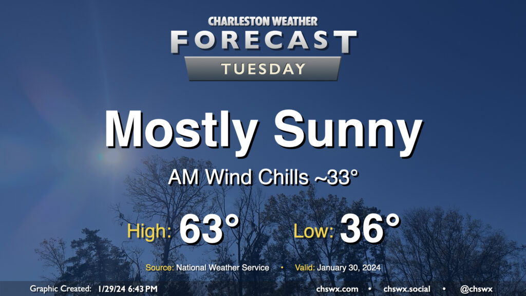
Expect another seasonally-appropriate day on Tuesday, though we will start out a little cooler than we did on Monday. Lows should bottom out in the mid-30s, and with a little wind still blowing, it’ll feel a few degrees cooler. Temperatures should head to the low-to-mid-60s under mostly sunny skies. Winds will shift southerly and pick up a bit in the afternoon ahead of a weak low, nudging dewpoints up a few degrees but certainly nothing outrageous.
Temperatures will be much more seasonable this week as a trough re-establishes itself in the east over the next few days, though we will still run a couple degrees above late-January and early February normals (highs generally in the low 60s). Weather will be generally quiet this week as generally dry air and surface high pressure generally rules the roost. The main exception will be Wednesday as an upper low dips nearby, instigating surface low pressure across the Carolinas, but even then the risk for showers will be generally very limited given the dearth of moisture. Quiet weather resumes Thursday through Saturday before another storm system develops in the Gulf of Mexico and strafes the area to the south. Drier air will again limit our rainfall potential, but we will turn a little cooler heading into next week as another upper low lumbers through the area.
After setting a daily high temperature record and tying the monthly high temperature record for January today, we have one more warm day for Saturday before a front brings temperatures back down to earth on Sunday. We start Saturday in the low 60s once again before warming to the mid-to-upper 70s in the afternoon. Scattered showers should be a factor ahead of the aforementioned front, but coverage won’t really amount to much until we get into the overnight as the front moves by. Showers will taper off early Sunday morning, and as cooler and drier air moves in behind the cold front, cloud cover will break up. Temperatures will be held to the mid-to-upper 60s as gusty west winds — perhaps with gusts approaching 30 MPH in the early afternoon — blow into the area. More normal temperatures return for next week, with a stretch of quiet weather expected to close January and start February.
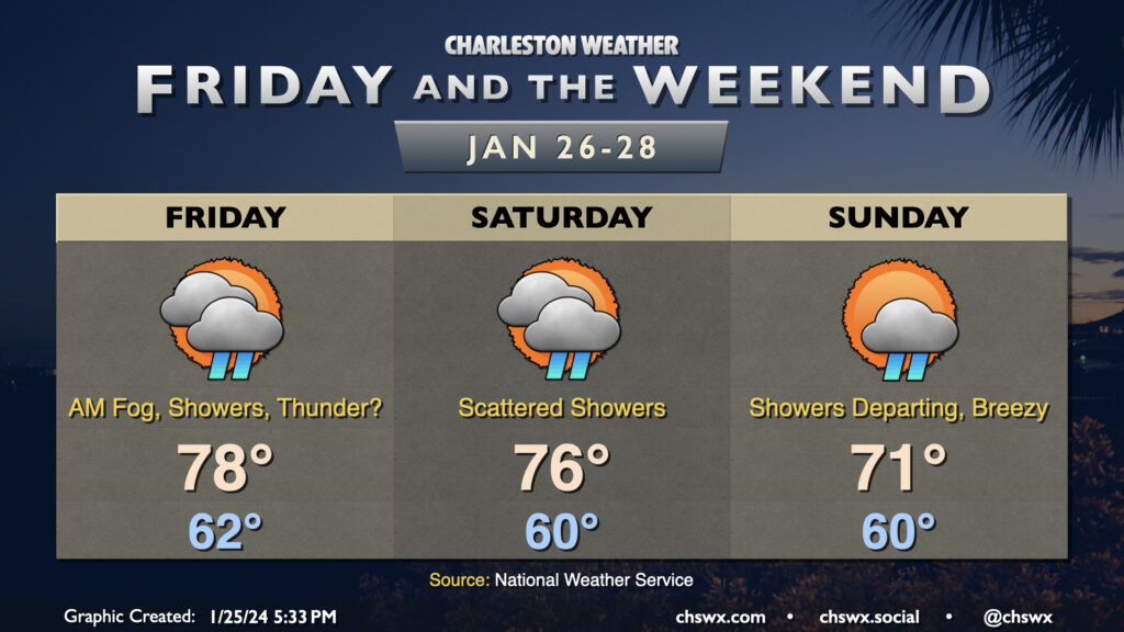
More warm and occasionally unsettled weather is on the way for Friday and the weekend. Lows will continue to run where January normal highs should be, and highs will still run well above normal, especially Friday and Saturday. In fact, Friday’s forecast high of 78° gets close to the record high of 80° set in 1950. The warm starts will lend themselves nicely to fog potential in the mornings, and sea fog may be persistent throughout the day as the warmer air overtops the much cooler waters.
Showers remain in the forecast as well as we stay within the warm sector of a stalled out frontal system. Friday could even feature a few thunderstorms, but severe weather is not anticipated. Saturday will once again feature a scattering of showers and maybe a rumble of thunder as well. A stronger front will push into the area on Sunday, pushing through later in the day to clear us out and cool us off. Showers and a few thunderstorms will be possible ahead of this front as well early in the day, but once the front is through — generally thinking early to mid-afternoon — the shower threat will end, cloud cover will decrease, and dewpoints will begin to fall.
Much more seasonable weather returns to the area starting Monday, with generally quiet conditions through at least Thursday.
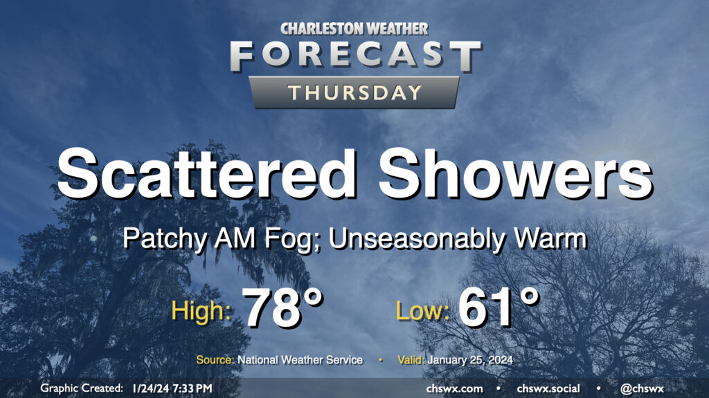
We hit 77° at the airport on Wednesday, narrowly missing a record high by two degrees (79°, set in 1950 and tied in 1974) and making this the warmest day so far in this young year. We have a chance to top that on Thursday despite showers working their way into the area as we stay within the broad warm sector of a storm system in the mid-South. We should start the day with some patchy fog as lows fall to the low 60s, right around the normal high for this point in the year. Temperatures will then warm to the upper 70s, and there’s a more-than-decent shot that some spots reach 80°. (The record high for January 25 is 82°, set in 1949.) A few showers will be possible across the area during the day, but coverage should be relatively sparse.
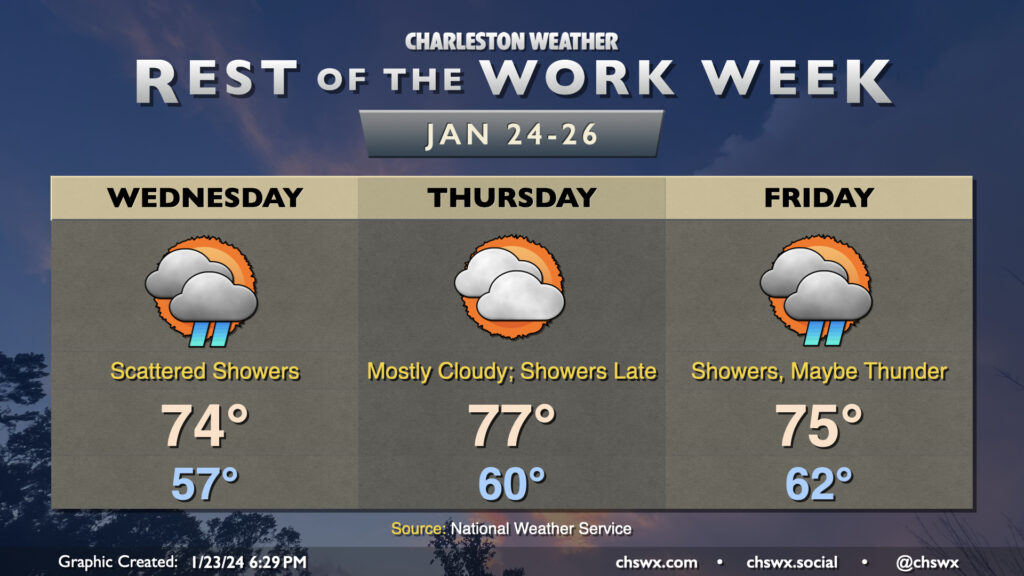
The warming trend continues Wednesday as a warm front lifts north of the area. Temperatures start in the mid-to-upper 50s owing to cloud cover blanketing us for much of the night. Once the warm front shifts ashore and winds go southeasterly, temperatures will respond further and head to the mid-70s. It’ll be kind of muggy, too, with dewpoints in the mid-60s expected behind the warm front. Scattered showers will remain possible throughout a fair bit of the day, though we should see more sun than we did Tuesday (not hard to do, tbh).
At a minimum, we’ll get the first part of Thursday in rain-free, if not the vast majority of it, before a front approaches the area and reintroduces shower and storm chances for Friday. Temperatures will peak Thursday, with lows in the low 60s and highs topping out around the mid-to-upper 70s. There will be a chance for a few showers late, but most of us should stay out of that until Friday, when shower coverage looks to increase with some thunder possible as well. Severe weather currently doesn’t appear to be a concern, though, as wind fields are largely unimpressive and instability appears meager. Temperatures on Friday will be tamped down a little by the shower activity, “only” reaching 75° after starting in the low 60s once again. We stay in the 70s on Saturday, but a second, stronger front will restore order to temperature chaos on Sunday, and by Monday, expect temperatures near normal with much more sunshine.