Jared Smith founded @chswx on Twitter in 2008 as an experiment in disseminating weather data through social media. In the ensuing decade-and-a-half, @chswx has provided live coverage of tropical cyclones, tornadoes, severe weather, and even a couple bouts of winter weather to the good people of Charleston, SC.
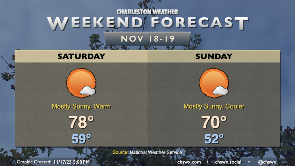
Showers will depart overnight Friday, and we look to have a rather nice and warm Saturday ahead. We’ll start the day in the upper 50s and warm to the upper 70s in the afternoon with plenty of sunshine to be had. A cold front will then pass through Saturday evening with nary a whimper, just a gradual drop in dewpoints with temperatures to follow. We start Sunday in the low 50s — a few degrees warmer than recent forecasts — and warm to about 70° in the afternoon. Sunshine will once again be in abundance, and it’ll be another gorgeous (and more seasonally-appropriate) weather day.
Looking ahead: Showers will return to the forecast for the first half of Thanksgiving week with temperatures generally around or above mid-late November norms. From there, a strong cold front looks to sweep through, knocking temperatures down well below normal — thinks highs in the upper 50s to around 60° — just in time to make Thanksgiving Day feel like, well, Thanksgiving Day.
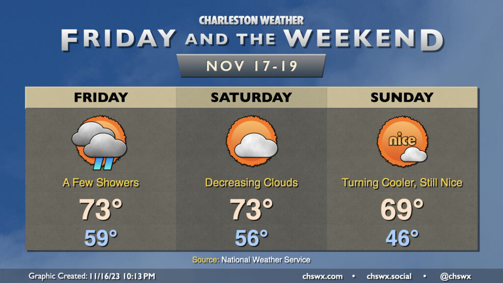
Showers will gradually depart as Friday wears on thanks to low pressure moving away from the area. It’ll be an unseasonably warm day, with lows starting near 60° before temperatures top out in the low to mid-70s in the afternoon. We’ll see some breaks in the clouds between showers, so once again, we’re not expecting a totally gray, washed out day. The only other issue will be the potential for some minor salt water flooding around the 10:25am high tide; expect water levels to peak around 7′ or so, putting some salt water once again on Hagood at Fishburne and perhaps on Lockwood. Widespread flooding issues are not expected.
The weather improves just in time for the weekend. Clouds will be decreasing Saturday as deeper moisture departs. We start the day in the mid-50s before warming into the low 70s in the early afternoon. From there, a cold front will get through later in the day; expect a dry passage thanks to much drier air in place. Sunday will be noticeably cooler — expect lows in the mid-40s, some 10° cooler than Saturday morning — before warming to around 70° in the afternoon.
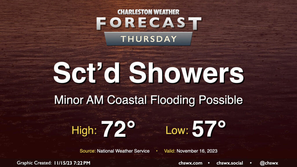
This week’s shower chances will peak Thursday as a disturbance moves across the Gulf Coast, spawning low pressure off the Florida coast. Expect shower activity to generally be scattered in nature, though, with some dry periods and maybe a few breaks in the clouds possible at times. Warmer air will make inroads as the wedge of high pressure which kept temperatures fairly well suppressed over the past few days begins to give way. Expect highs to top out in the low 70s in the afternoon as a result.
There will again be the risk for some minor coastal flooding with Thursday morning’s high tide, which is expected to peak around 9:33am. Much like Wednesday morning, water levels should reach 7-7.2′ again, which should be enough to put some salt water on the roads but not enough to begin to introduce widespread issues. Still, the vulnerable locations on the west side of the peninsula near The Citadel and Gadsden Green will likely take on salt water once again during the morning. Be ready to reroute around flooded roads.
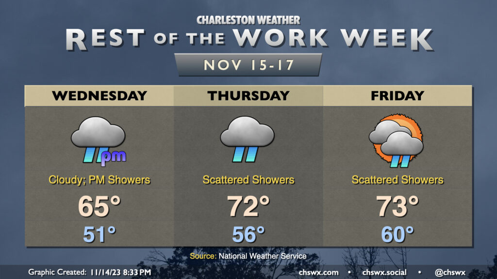
Showers re-enter the weather picture for the second half of the work week, though we’ll warm up a little in the process. Expect overcast on Wednesday before scattered showers commence in the afternoon. It doesn’t look like it’ll be a terribly heavy rain, but it could be enough to make the roads a little slick, so be careful when commuting. Temperatures start in the low 50s and rise to about the mid-60s in the afternoon as the cool wedge of high pressure hangs on for one more day.
The wedge starts to weaken Thursday, and despite overcast with periods of showers continuing, temperatures will run a little warmer. Expect mid-50s to start with low 70s in the afternoon. A few peeks of sun will be possible Friday, though scattered showers are expected to continue. Temperatures will run even warmer Friday, with lows around 60° and highs in the low-to-mid-70s.
Minor coastal flooding will continue to be possible with the morning high tides heading into the weekend. Water levels will generally peak around 7-7.1′ or so each day, which is enough to put some salt water on vulnerable roads in downtown Charleston. The highest tide capable of producing flooding on Wednesday is predicted around 8:47am, Thursday a little after 9:30am, and Friday around 10:30am. Stay tuned for Coastal Flood Advisories from the National Weather Service.
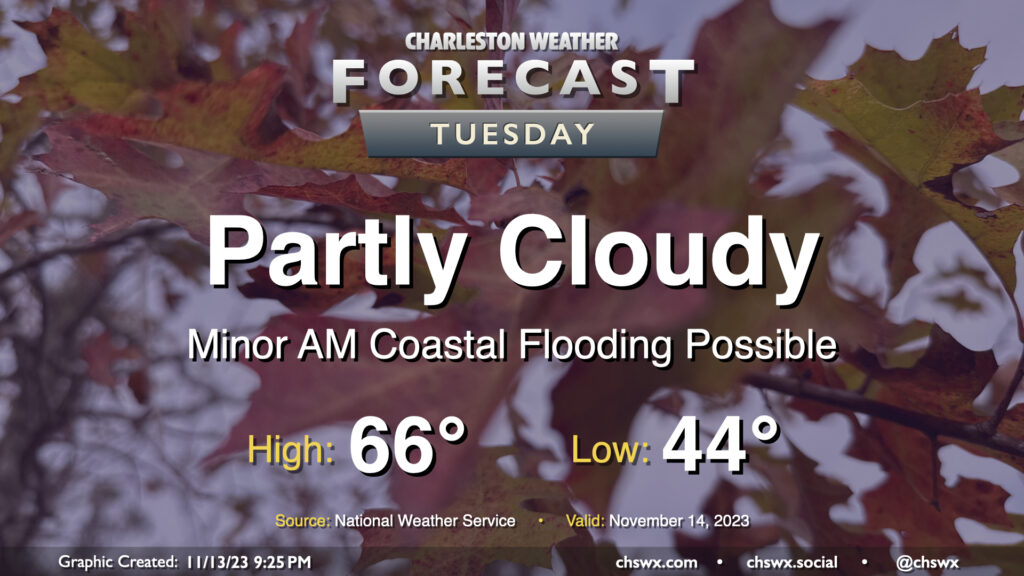
Another seasonably cool fall day awaits for Tuesday as we start to see an uptick in cloud cover portending more unsettled weather beginning later Wednesday into the rest of the work week. Temperatures start in the mid-40s before heading to the mid-60s in the afternoon, a couple clicks below normal but certainly very seasonally-appropriate. We’ll see ample sunshine, too, but as mentioned, cloud cover will begin to head up as we get into the evening.
High tide a little after 8am will be capable of producing some minor coastal flooding, with water levels generally approaching 7′ or so. It’ll be enough to put salt water on the most vulnerable roads — think around Hagood and Fishburne — but won’t cause widespread problems. Still, be ready to reroute around salt water-covered roads Tuesday morning.
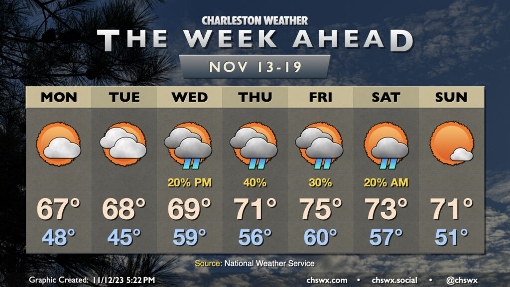
After a dreary weekend, some sun begins to peek back out for Monday, and this will help temperatures get closer to — but still a touch below — mid-November norms. Expect highs in the mid-to-upper 60s Monday through Wednesday, with high temperatures reaching the low 70s starting Thursday and continuing into the weekend, with a slight cooldown for Sunday in the wake of a weak cold front.
Clouds will steadily increase through the first part of the work week as a reasonably vigorous disturbance ejects out of the southern Plains, with surface low pressure moving southeast from the Gulf Coast toward the Florida peninsula, dragging an inverted trough to its north that will help be a forcing mechanism for some shower activity here at home. There’s a slight chance of showers as soon as Wednesday, with rain chances peaking Thursday before gradually tapering Friday and perhaps into Saturday depending on the timing of the trough’s exit and the aforementioned front crossing the area. Most of Saturday should be rather nice, and Sunday will offer even more in the way of sunshine.
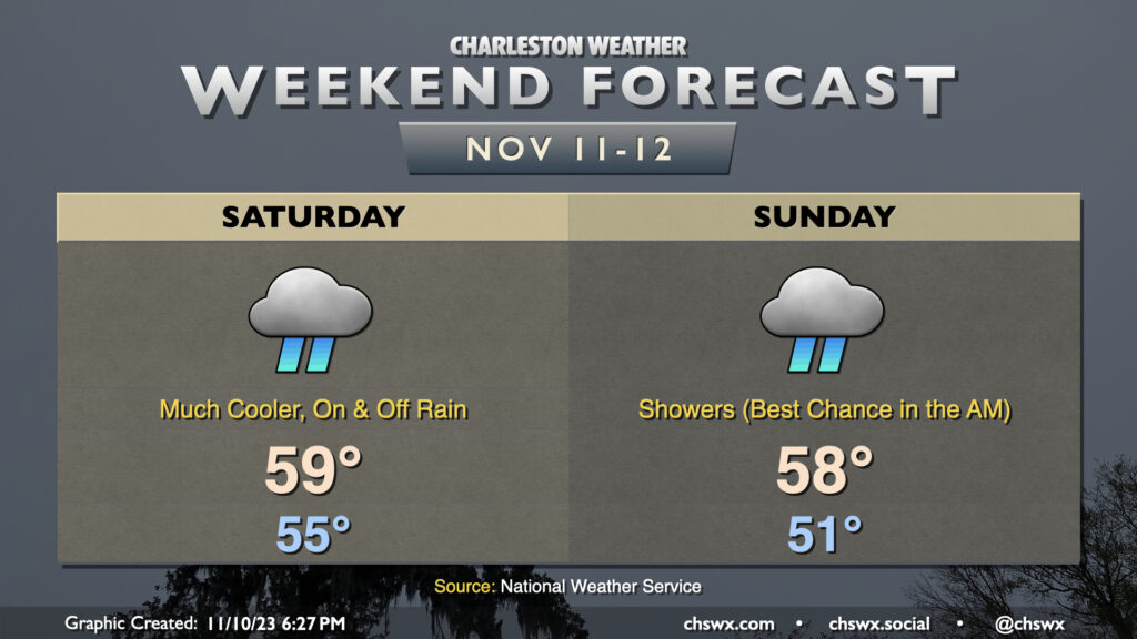
Remember rain? It will be back starting Saturday, along with quite the cooldown in the wake of a cold front that gets through late Friday night. We start Saturday in the mid-50s, but cloud cover and rainfall will keep temperatures from warming all that much — in other words, unless you’re closer to the coast, it’s pretty unlikely you’ll sniff out 60°. Rain continues heading overnight Saturday into Sunday as moisture lifting across the wedge along with a disturbance keeps rainfall in the forecast through at least Sunday morning. We should start to see precipitation taper off heading into Sunday afternoon, though we stay chilly with highs once again expected to stay suppressed to the upper 50s. (Naturally, sun starts to break through Monday, and temperatures begin to warm from there.)
We will need to watch Sunday morning’s high tide (6:50am) for the potential for some coastal flooding as the northeasterly winds help drive water level departures higher. Expect generally minor coastal flooding, though it may yet be high enough to close a few roads for a time. We could see similar flooding Monday morning as well. Stay tuned for Coastal Flood Advisories from the National Weather Service.
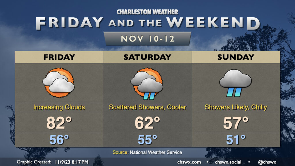
If you’ve been a fan of this recent warm weather, soak Friday in, because that’s going to do it for the 80s for a little while. Clouds will be increasing ahead of a cold front that will be moving by late Friday night, which will usher in a much cooler airmass for the weekend and beyond.
Cool high pressure will wedge southward overnight Friday into Saturday, and we’re going to feel it in the way of lows that’ll run ~20° cooler than what’s expected Friday (low 60s vs. low 80s). Overrunning moisture atop the wedge could bring some showers to the area for Saturday, especially later in the day. The better chance of showers will arrive with a round of mid-level energy that’ll move by Sunday. The expected clouds and showers will keep highs suppressed to the upper 50s at best. We’ll also need to keep an eye on Sunday morning’s high tide for the potential for minor coastal flooding thanks to the northeasterly winds driving up tidal departures.
Overall, it’ll be good to get our first measurable rain of the month as abnormally dry conditions continue to spread across the Lowcountry, even if the weekend is not an ideal time. We’ll see rain taper off later Sunday and some more sunshine as we get into Monday and beyond, though temperatures will remain generally below normal for this point in the year with highs in the mid-60s each afternoon.
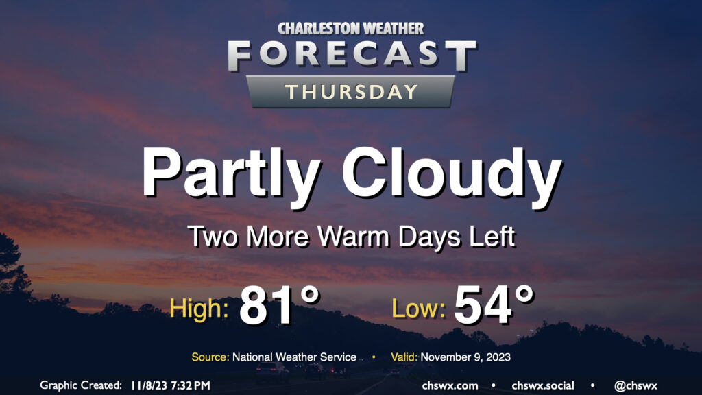
After narrowly missing a record high on Wednesday (the high was 84°, which approached the record of 85° set in 1986), we have another warm day on tap for Thursday. We start the day in the mid-50s before temperatures head to the low 80s in the afternoon under partly cloudy skies — yet another rain-free day as we start November. The rain-free streak looks to come to an end this weekend, though, as a cold front moves by and high pressure wedges southward.
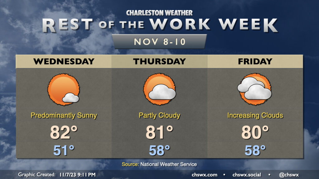
We have a few more days of above-normal warmth before changes in the form of a cold front and subsequent wedge of high pressure arrive for the weekend. For Wednesday, expect another predominantly sunny day starting around 50-51° before warming to the low 80s in the afternoon. Thursday gets off to an even warmer start as lows bottom out in the upper 50s. A few more clouds will dot the sky on Thursday, but we should still have no trouble reaching 80-81°.
Cloud cover continues to increase as we head into Friday, which will be the last of this long stretch of above-normal temperatures (for now, anyway). High temperatures will run in the low 80s for one more day as warm air pumps into the area ahead of a cold front. It increasingly appears we’ll stay rain-free Friday as the front looks to pass through Saturday morning, bringing with it a few showers and much cooler temperatures for the weekend into next week. It won’t be much in the way of rain, but any little bit helps as abnormally dry conditions continue to spread across the area.