Jared Smith founded @chswx on Twitter in 2008 as an experiment in disseminating weather data through social media. In the ensuing decade-and-a-half, @chswx has provided live coverage of tropical cyclones, tornadoes, severe weather, and even a couple bouts of winter weather to the good people of Charleston, SC.
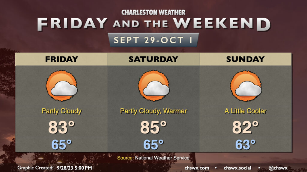
Sunday should have a similar flair to Saturday with scattered storms and sunshine mixing in afterward. Like Saturday, we could see a few storms possible in the morning before gradually pushing inland during the day. And like Saturday, we should also see some decent sunshine kick in as well, with highs approaching 90° in the afternoon. Overall, not expecting a full rainout anywhere, but a few spots could see some heavy downpours with a quick inch of rain or so possible (much like parts of West Ashley and North Charleston saw this morning!)
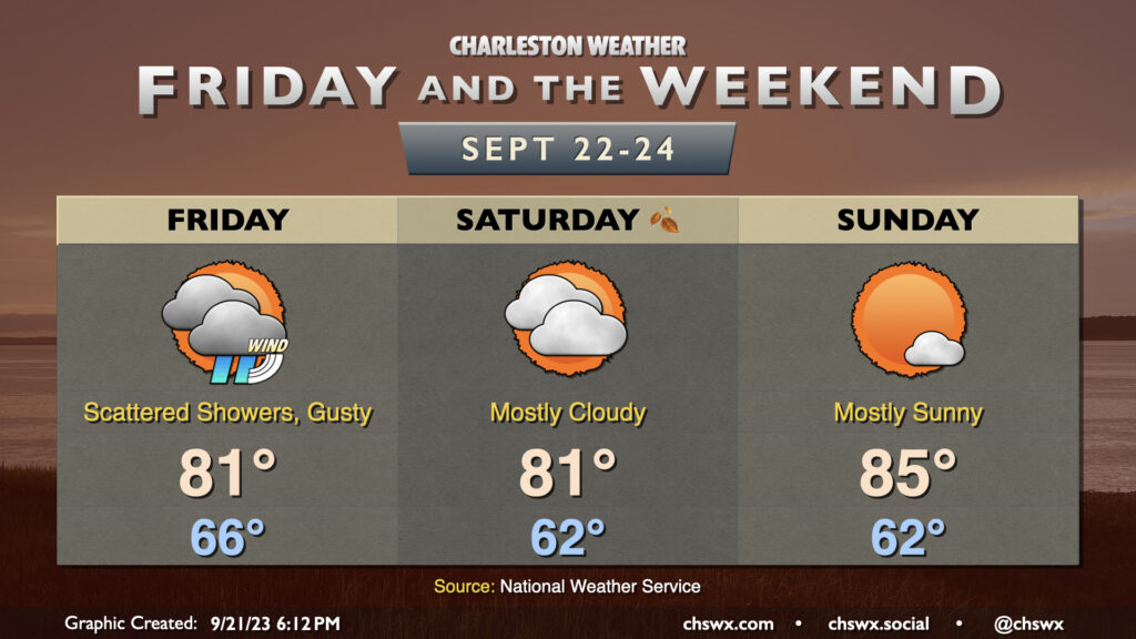
Showers and thunderstorms will be off and on throughout the weekend, particularly Saturday as a disturbance aloft ripples through the area. Winds turning onshore will bring some more moist air into the area, and we could see showers and thunderstorms begin to affect the area by daybreak. Some spots could see some fairly heavy rain at times, and a strong or severe storm isn’t totally out of the realm of possibility (though is rather unlikely). It won’t rain all day, but be ready to enact indoor plans on Saturday if necessary. Highs top out in the mid-to-upper 80s given the cloud cover and rain expected.
Storms should be a little more sparse coverage-wise throughout the day Sunday, though most of us should see at least some rainfall at some point throughout the day. Much like Saturday, the rain risk looks to start at the coast in the morning hours before shifting inland with the seabreeze in the afternoon. Once again, a storm or two could be strong, and some of the rain could be heavy at times, but widespread severe weather just doesn’t seem to be in the equation. Highs on Sunday run a click warmer, but still generally in the upper 80s.
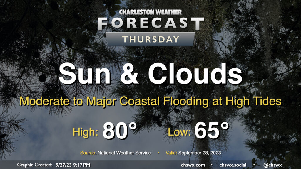
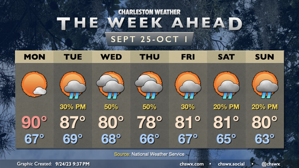
A stalling cold front and a cutoff low aloft will combine to bring shower and storm chances back to the area starting Friday afternoon, peaking on Saturday, and then gradually tapering on Sunday. Highs on Friday top out in the low 90s, with the best chance for showers and thunderstorms generally being found along and ahead of the seabreeze. With the upper low drifting across the area Saturday, showers and thunderstorms could fire at any point, with some guidance hinting at Saturday getting off to a bit of a soggy start as showers and thunderstorms drift inland. Highs on Saturday top out in the mid-to-upper 80s given the rain and cloud cover. We’ll see the upper low lift out of the area on Sunday, decreasing the risk of showers and storms somewhat, but coverage should still be decent given the nearby front.
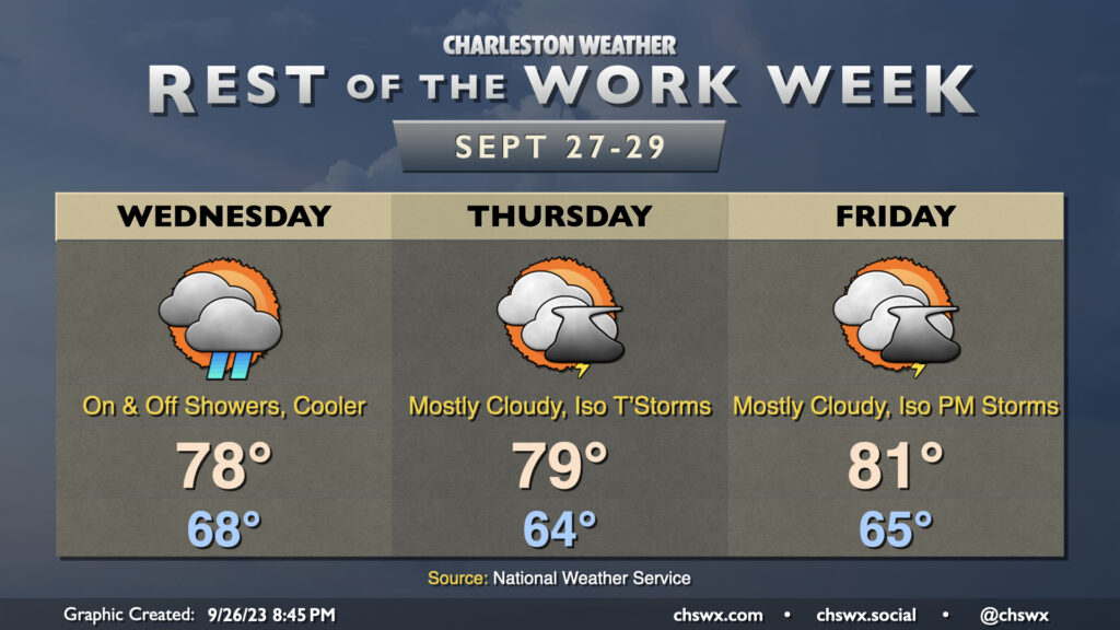
We have one more rain-free and rather warm day coming up on Thursday. Expect highs to once again top out in the mid-90s under partly cloudy skies, with some humidity mixing in to drive heat indices to the upper 90s to around 100°. It’s worth noting that the NWS forecast high of 95°, if it did indeed come to pass, would tie the daily high temperature record set in 1941 and then tied in 1947 and 2019. (For reference, last year’s high on September 7 topped out a degree shy of the record.) Ridging will weaken throughout the day, but much of us should expect to get the day in rain-free. I don’t know that I’d totally rule out a shower or storm closer to I-95, though.
The forecast for the rest of the work week is generally on track: Temperatures in the mid-90s will continue through Thursday with peak heat indices around 100° thanks to some, but not too much, humidity. Skies will generally run partly cloudy to mostly sunny. Storm chances don’t return to the picture until Friday, and even then, it looks like coverage will be more on the isolated side. The weaker ridge will keep temperatures running a little lower (low 90s) on Friday, but above-normal temperatures look to continue heading into the weekend despite steadily increasing storm chances as a front arrives and stalls out nearby. (Remember, normal is looking a little lower these days: normal highs for this week generally run around 87°.)
Plenty of sunshine is in the offing for the rest of the work week as high pressure remains the primary driving force for our weather. Temperatures climbed back into the low 90s on Labor Day, and this will continue as we head into the rest of the week, with mid-90s expected by mid-week. Dewpoints in the mid-60s will keep heat indices in the mid-90s on Tuesday, but as dewpoints creep up throughout the week, so it shall be with the heat index as well. Feels-like temperatures will be flirting with 100° again starting Wednesday through the rest of the week.
There’s not much in the way of rainfall to report on for much of the week with high pressure in control, but we start to see some cracks in the armor on Friday as a few storms should pop on the seabreeze, with slightly better coverage of showers and storms each afternoon this weekend.
Not sure if there are enough superlatives for how this Labor Day Weekend looks, weather-wise. Temperatures will be comfortably warm with reasonable humidity all weekend. Expect mid-80s Saturday and Sunday before we turn back toward 90° on Monday, though dewpoints in the mid-60s should negate any heat index impacts. Clouds will be few and far between, with predominantly sunny skies dominating. It’ll be a truly fantastic long weekend of weather, and I hope you can take advantage.
The only issue we’ll run into is some tidal flooding with each high tide cycle through Sunday morning. After Friday evening’s expected moderate flood, we’ll only see minor coastal flooding thereafter. You’ll simply want to keep an ear out for Coastal Flood Advisories from the National Weather Service so you know when the risk for a few closed roads will be highest.
A nice round of decent and less-humid post-Idalia weather continues for Friday into the weekend. Expect highs in the mid-80s each day as high pressure wedges south into the area, with a string of lows in the mid-60s for the first time since early June expected. It will be comfortable outside — not too humid, not so dry that you need to constantly apply lip balm, either. Expect dewpoints to run in the low 60s for the next few days, yielding relative humidity values around 45-50% at peak heating. Not too shabby at all. The only fly in the ointment will be the potential for coastal flooding with each high tide cycle as winds go to the northeast and remnant water loading from Idalia. We should see minor flooding with the 9:16 PM high tide this evening along with the 9:37 AM high tide on Friday, with moderate flooding expected with Friday evening’s high tide peaking just after 10PM. This will cause some road closures in downtown Charleston, so be ready if you have plans downtown on Friday night. We’ll continue to see at least minor flooding with each high tide cycle this weekend, too, as the northeasterly winds — which are giving us this rather nice start to September — persist. It’s a small price to pay for what will be some of the best air we’ve felt in a while.
As we head into Sunday and Labor Day, Summer will get a proper sendoff with highs topping out closer to the upper 80s but with little appreciable change in dewpoints. Lingering high tides may keep the rip current risk elevated at the beaches, but otherwise, things look good. We stay rain-free, in fact, through Thursday as temperatures head back into the 90s next week. Enjoy!
After a somewhat wild day at times with Idalia, Thursday will provide much, much better weather. Lingering breezy conditions and cloud cover will give way to mostly sunny skies by afternoon, with highs topping out in the low 80s as northwest winds bring some drier air into the area. This will kick off a nice Friday and long weekend, too. We’ve earned it, methinks.
Thanks for following along, as always, throughout Idalia. Your reports were invaluable to NWS warning operations and helped your neighbors stay in the know about what was happening. Social media, for all its problems, can still be super cool in times like these.
Idalia is back to being a tropical storm this evening. As of the 5PM fix from the National Hurricane Center, Idalia was centered about 40 miles west of Savannah (or 115 miles WSW of Charleston) and was moving northeast at 21 MPH. Maximum sustained winds were at 70 MPH and continuing to fall. Tropical Storm Warnings continue, a Tornado Watch remains in effect until 10PM, and a Flood Watch continues until 2AM. The Hurricane Watch was dropped at 5PM after Idalia was downgraded.
Idalia has been a pain so far today in the Lowcountry, with numerous tornado warnings (and some possible touchdowns, including a car getting tossed in Goose Creek) and very heavy rain in spots. Radar is generally estimating about 1-3″ so far, with some more to fall as rain bands continue to move through. The heaviest rain still looks to be positioned to move up through the Midlands, but may scrape parts of far inland Dorchester and Berkeley counties.
Closer to the coast, we will be dealing with increasingly gusty winds — gusts to tropical storm force appear likely across the barrier islands into downtown and Mt. Pleasant — as well as significant coastal flooding punctuated by a forecast 8.7′ high tide which would rank among the top ten on record. The water level in the harbor as of about 5:45 PM was already up to 6.06′, which is a departure of a little over 1 and ½ feet. High tide is expected to peak around 8:30. Numerous road closures are expected; in fact, around this time it’s probably best to just be where you’re going to be. Any heavy rain bands that develop and move over will exacerbate flooding, perhaps making for a widespread problem downtown and on barrier islands.
After 2-3am, we should start to see improvement, though gusty winds and maybe some showers will persist into Thursday. For now, though, keep phones charged and weather radios on standby in case you lose power. Be safe — we’ll be done with Idalia before you know it.