Jared Smith founded @chswx on Twitter in 2008 as an experiment in disseminating weather data through social media. In the ensuing decade-and-a-half, @chswx has provided live coverage of tropical cyclones, tornadoes, severe weather, and even a couple bouts of winter weather to the good people of Charleston, SC.
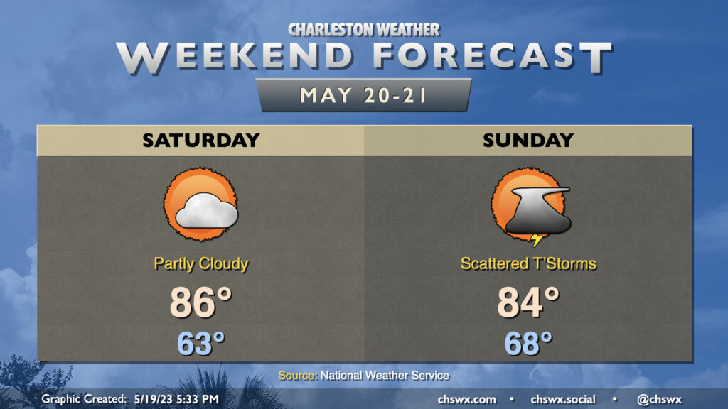
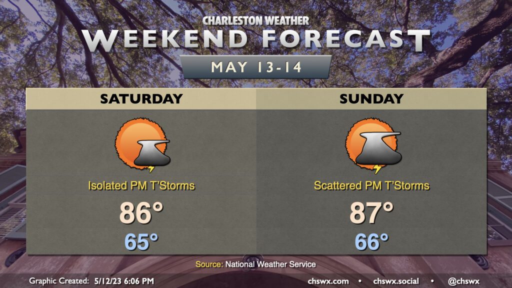
We get a brief break from showers and overcast on Saturday as low pressure moves further away and high pressure makes a brief appearance. We’ll start the day in the low 60s with broken cloud cover before warming to the mid-80s in the afternoon under partly cloudy skies. Shower chances are very low, but it wouldn’t shock me to see a couple well inland as a cold front pushes closer to the area.
Said cold front should instigate scattered showers and thunderstorms for Sunday. After a mild start in the upper 60s, temperatures should top out in the mid-80s, likely governed by cloud cover and shower activity. It doesn’t look like a total washout, but be ready to move indoors at times. Severe weather doesn’t look to be a factor, but lightning makes all thunderstorms dangerous. When thunder roars, go indoors!
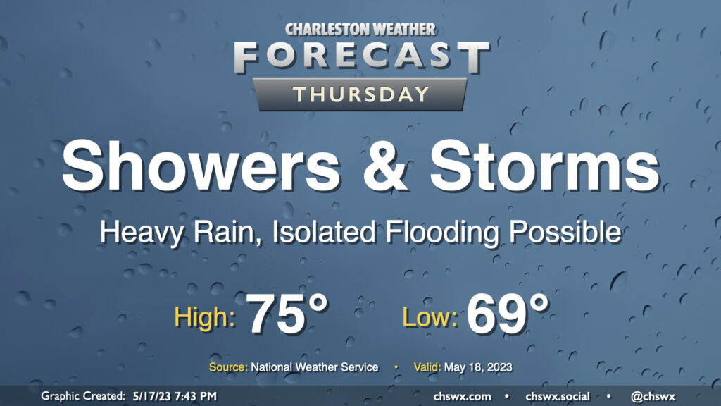
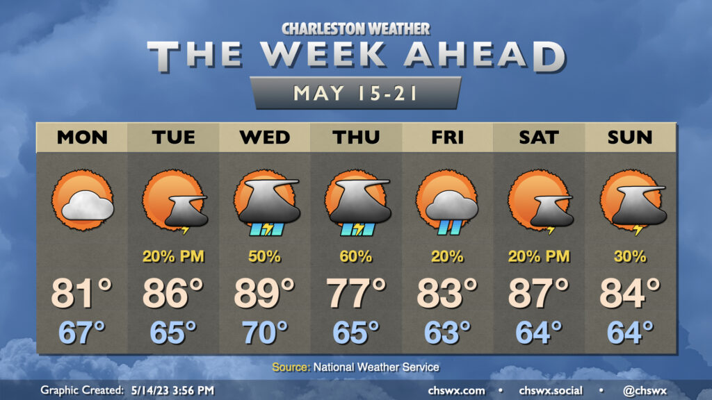
A cold front will slowly push south across the area overnight into Thursday, but it will not bring rain chances to a close. Moisture riding atop a wedge of high pressure will keep plentiful showers and maybe some thunderstorms in the forecast. Some spots may see an additional 1-2″ of rain on top of the rain that fell on Wednesday, and additional bouts of flooding may be possible as a result. The risk for severe weather will be lower given the widespread precipitation as well as the cooler temperatures, especially behind the front. Expect highs to only top out in the mid-70s with a breezy northeasterly wind.
We’ll need to monitor for the risk for moderate coastal flooding with the 8:08 PM high tide. The current forecast is for water levels to peak between 7.5-7.7′, which should be enough to close several roads in downtown Charleston. We will obviously want to watch very closely for the prospect of heavy rain in the area around this time as the coincidence of the two would be decidedly not great. Stay tuned to forecasts throughout the day, especially if you have downtown in your plans Thursday night.
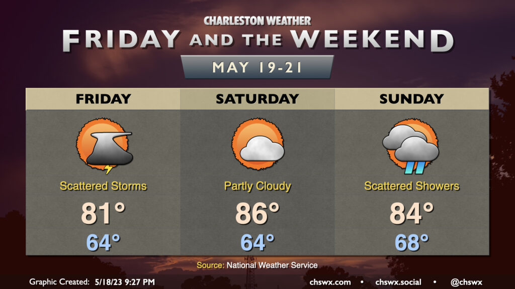
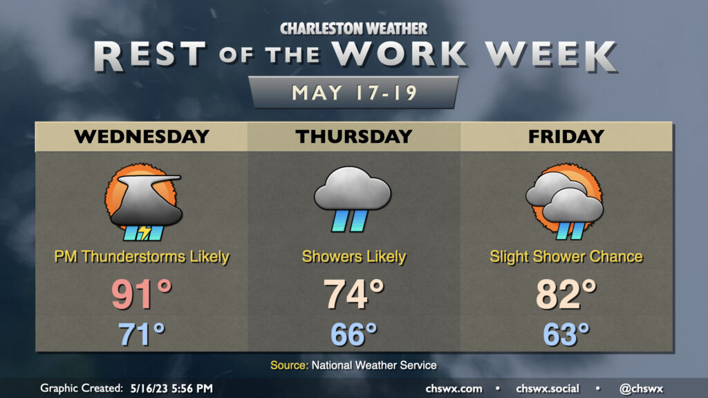
The rest of the work week will be on the unsettled side as a cold front moves back into the area from the north. Wednesday will, by far, be the warmest day of the set as highs top out in the low 90s before showers and thunderstorms initiate by mid-afternoon. Heavy rain will be possible within thunderstorms, and some minor flooding can’t be totally ruled out where storms set up. Severe weather is unlikely, but a sporadic damaging wind gust or two can’t be totally discounted.
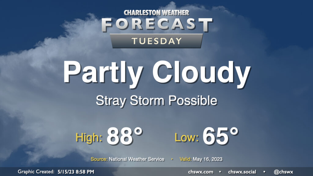
A warm front will lift north of the area tomorrow, bringing in even warmer and more humid air for Tuesday. Much of the day should stay rain-free with relatively weak instability, though a stray shower or storm near the seabreeze can’t be discounted. If a storm or two does form, note that storm motions will once again bring them toward the coast, so be aware of that if you have a Tuesday beach trip planned. (Lucky duck.) Expect highs to top out in the upper 80s; I wouldn’t be shocked to see a 90° reading somewhere, either.
The week ahead will be unsettled at times as a ridge of high pressure to the west retreats, allowing mid-level impulses and another cold front to drive into the area to keep showers and storms in the forecast.
Confidence is increasing in showers and thunderstorms affecting the area Sunday afternoon and especially as we get into the evening hours. We’ll start Sunday on a warm note, generally in the mid-60s, before warming quickly well into the 80s by midday. Scattered showers and storms should begin to kick off as the seabreeze develops and moves inland early in the afternoon, and coverage should increase as a front approaches the area from the northeast as we head into the late afternoon and evening. Severe weather isn’t anticipated, but lightning makes every thunderstorm dangerous, so be sure to move indoors if thunderstorms threaten. Winds around a ridge of high pressure to our west will also bring storms toward the coast, as well, so be alert if the beach is in your plans. Overall, it’s not a day to cancel outdoor plans, but have a solid indoor plan B in case storms come by.
We will turn warmer this Mother’s Day weekend as high pressure continues to slip offshore and some ridging builds in aloft. Saturday looks to be the pick day of the weekend, with the day starting in the mid-60s and highs topping out in the mid-80s in the afternoon. A stray shower or thunderstorm is possible Saturday afternoon, but many of us should stay dry.
Afternoon thunderstorm chances tick up for Sunday as a front approaches the area. Highs top out in the mid-to-upper 80s after another start in the mid-60s. Depending on when storms can get going, a few 90° readings wouldn’t be out of the question, particularly further inland. No organized severe weather is expected, but a storm with a few strong wind gusts can’t be totally discounted especially where boundaries interact. Storm motions could bring activity toward the coast, too, so be alert to changing weather if your Mother’s Day plans include the beaches.
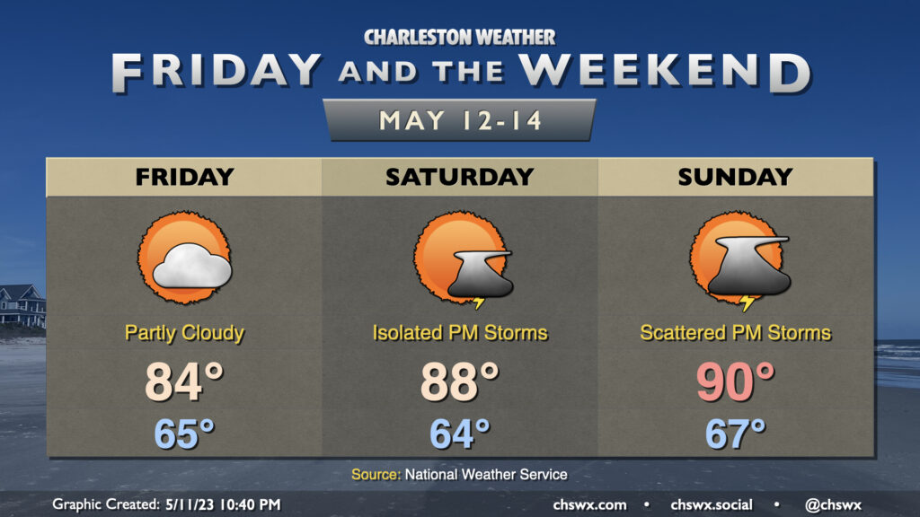
We’re turning warmer to close out the work week and head into the weekend as high pressure shifts offshore and winds go more southerly. Friday tops out around 84° with a low in the mid-60s, while Saturday heads to the upper 80s and Sunday tops out near 90° as ridging builds in aloft.
We look to stay rain-free Friday, but a storm or two will be possible Saturday afternoon with slightly better storm chances Sunday afternoon into the evening hours. Some spots may see some brief downpours and some gusty winds, but it’s not looking terribly favorable for organized severe weather. That being said, storm motions will be coastward, and so if you head to the beaches or are otherwise out and about, keep an eye to the sky and be ready to head indoors if weather conditions take a turn. Remember, when thunder roars, go indoors!
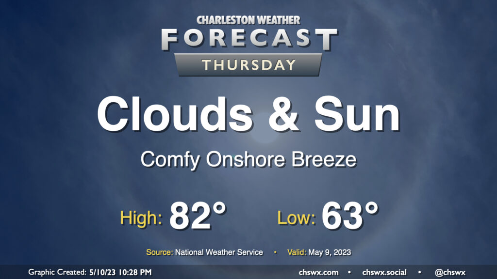
Not much to write home about weather-wise on Thursday. We’ll see a mix of clouds and sun throughout the day and continued comfortable temperatures; lows start in the low 60s with highs topping out in the low 80s in the afternoon, with an easterly breeze and the expected broken cloud cover to be a contributor to those temperatures. All in all, no hazards are expected and it should be a fine day.