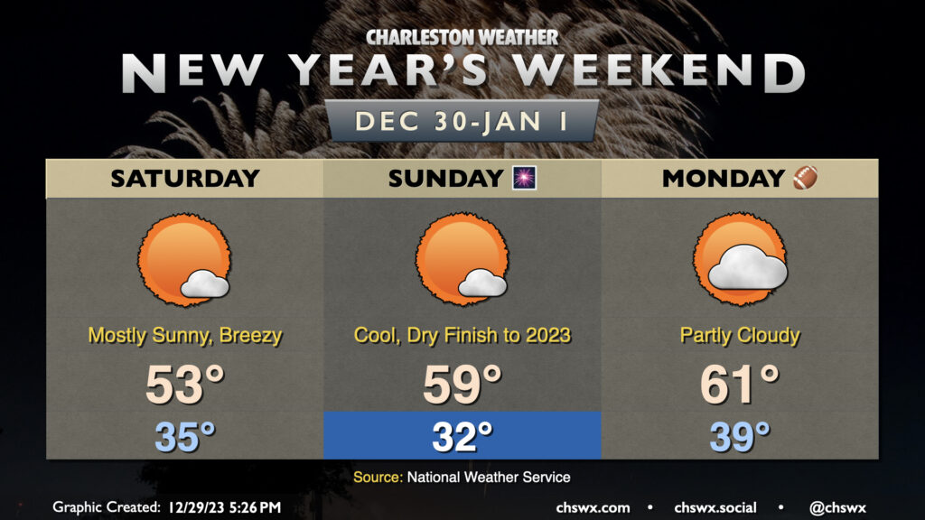
We’ll depart 2023 and enter 2024 with a minimum of meteorological fanfare as high pressure remains in control through Monday. Temperatures on Saturday will start in the mid-30s, but elevated winds will make it feel closer to the upper 20s. Highs will only top out in the low 50s as gusts reach 25-30 MPH once again during the prime heating of the day. The chill is in spite of nearly full sunshine, though much like Friday, a fair-weather cumulus field should take shape.
Clear skies and diminishing winds will improve radiational cooling conditions overnight Saturday into Sunday, and so we should start the day around the freezing mark away from the coast. Another mostly sunny day lies ahead, and a warming trend will start to kick in as the core of the cold air moves out. Expect temperatures to head close to 59-60° in the afternoon, right in striking distance of December 31 norms. There are no weather concerns for New Year’s festivities on Sunday night except for the need for a jacket — it’ll be getting into the low 40s in many spots as we ring in 2024.
New Year’s Day will start a little warmer, with lows in the upper 30s to around 40° warming to the low 60s in the afternoon. There will be a little more cloud cover ahead of a cold front that’ll swing through overnight Monday into Tuesday with a slight chance of a few showers. The next substantial rain chance appears to be next Thursday with a stronger front moving by, followed by high pressure leading into the first weekend of 2024.
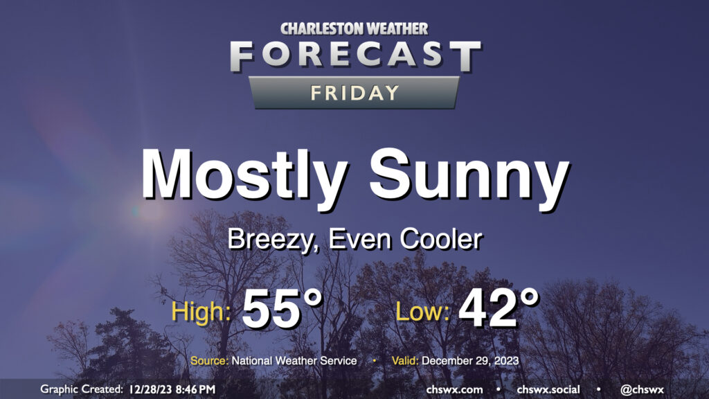
A cold front coming through overnight will send temperatures even cooler for Friday. We start the day in the low 40s, but cold air will be blowing in throughout the day. This will keep temperatures suppressed to about the mid-50s in the afternoon despite mostly sunny skies. It’ll be a breezy day, too; winds will generally run 10-15 MPH with gusts to 25 MPH as daytime heating helps push mixing heights to about 5,000 feet. Cloud cover will generally be sparse with a fairly dry atmosphere in place, with maybe a few fair weather cumulus showing up from time to time.
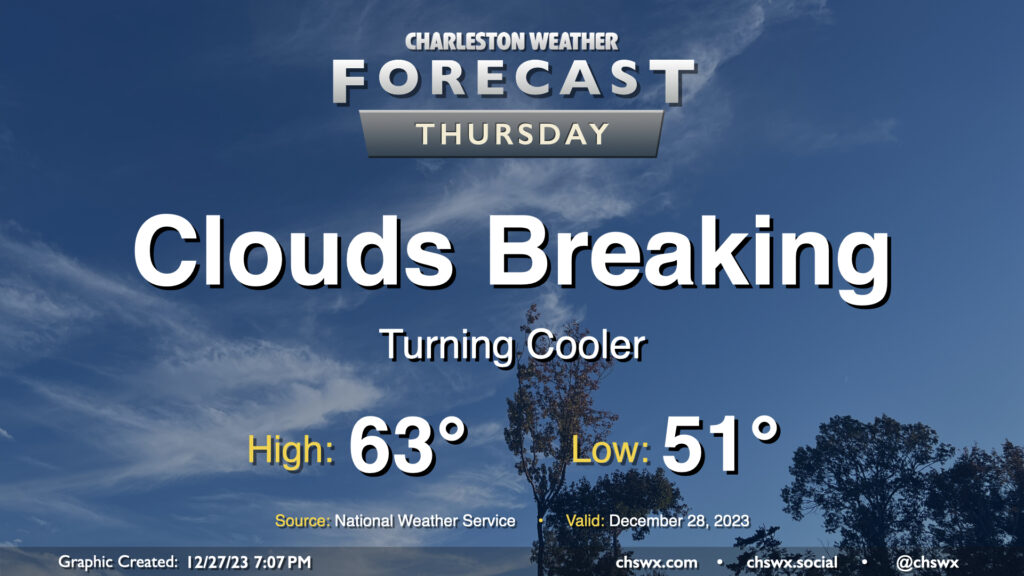
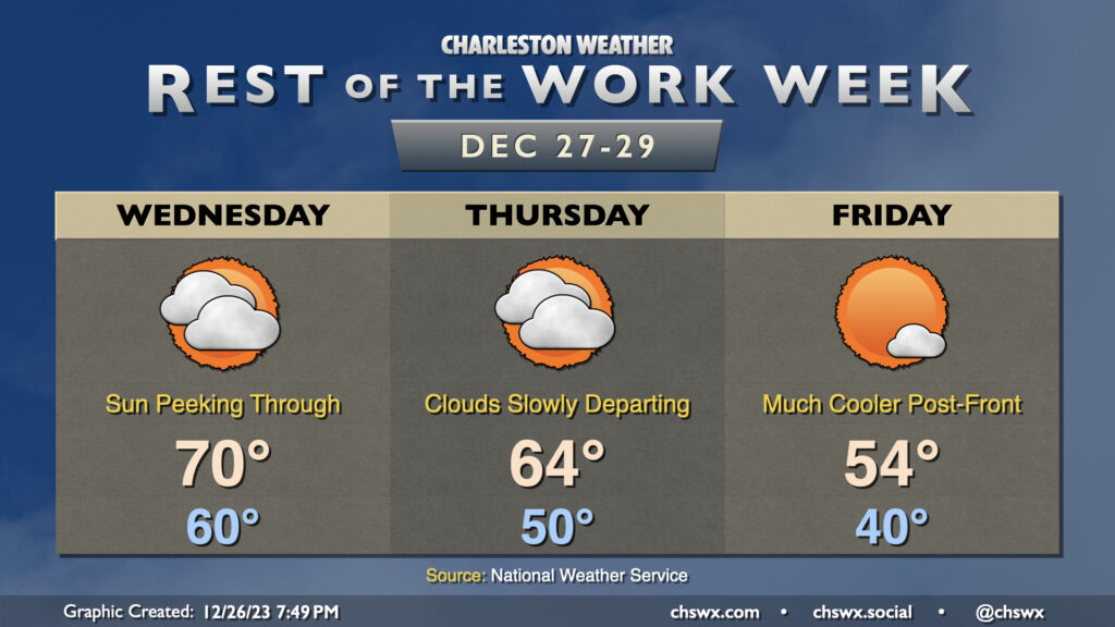
Thursday will be a much cooler day than Wednesday was across the Lowcountry, where most stations made it into the 70s at some point during the day, as an initial round of cooler and drier air infiltrates the area ahead of a reinforcing front which will really chill us out for Friday into the weekend. Dewpoints fall into the mid-40s throughout the night, allowing temperatures to drop generally into the low 50s to start Thursday. We’ll top out in the low-to-mid-60s in the afternoon — still a touch above normal — as clouds gradually start to break up along with the cold front’s passage.
After low pressure departs the area early Wednesday morning, that will be it for rain for 2023 as we’ll embark on a drying and (slow) clearing trend heading into New Year’s Weekend. Wednesday will probably be the last day we touch 70° this year as cooler and drier air starts to work into the area later in the day. We’ll see dewpoints fall first and then temperatures will follow as we get into the evening hours. This’ll yield a Thursday that starts 10° cooler (but still well above late December normals) and warms to about the mid-60s in the afternoon. We should see a bit more in the way of sunshine on Thursday, but clouds will remain a bit pesky until a stronger (but dry) front gets through late Thursday. We’ll wake up another 10° cooler on Friday, with lows in the upper 30s to around 40° yielding to highs just in the mid-50s as cooler air works into the area throughout the day. At least the sun will be out!