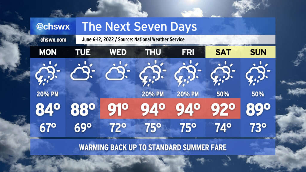
Overall, we’ve got a pretty standard June week ahead in the Lowcountry, with temperatures turning warmer as the week progresses. We’ll go from the mid-80s on Monday to the mid-90s by Thursday and Friday ahead of a cold front that will approach the area for the weekend.
We’ll have the customary summertime slight shower and thunderstorm chance most afternoons (though Tuesday and Wednesday look more likely to stay dry than not). As we head toward the weekend, though, we’ll be watching the aforementioned front and a sharpening trough aloft for an uptick in shower and thunderstorm chances perhaps as early as Friday, but more likely as we get into the weekend. As is customary in June, showers and thunderstorms will be on-and-off, primarily concentrated in the afternoon, and not a total loss of a day as a result. (And yes, it’s too soon to say just how much of an impact we’ll see on the Spoleto finale at Firefly.) Just make sure outdoor activities have backup indoor plans in case showers and thunderstorms approach. While severe weather doesn’t look terribly likely, lightning makes every thunderstorm dangerous. When thunder roars, go indoors!
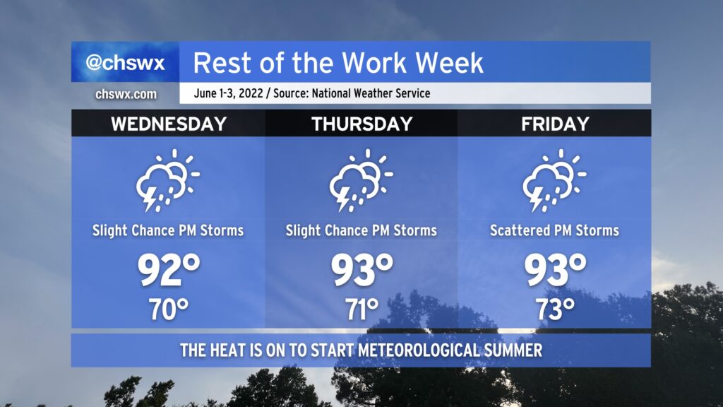
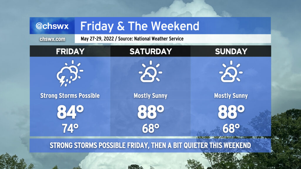
As we head into the weekend, we’ll get a break from the run of mid-90s that we’ve seen in the latter half of this abbreviated work week. This is courtesy of a cold front, which will sink southward across the area tonight bringing with it some showers and thunderstorms. Said front is expected to stall out to our southeast, and this combined with an influx of tropical moisture from what could be an eventual tropical cyclone well to the south and some energy rippling through aloft will be enough to generate periods of showers and thunderstorms for much of the day Saturday. It won’t rain all day at any one location, but be ready to move outdoor activities inside quickly in case the weather changes. Highs top out in the mid-80s on Saturday thanks to the cooler air and expected cloud cover. Sunday should be a little bit drier, though there will still be a slight chance of showers and thunderstorms. Highs once again will top out in the mid-80s, and with any luck, there will be longer breaks in the rain so you can enjoy it a bit.
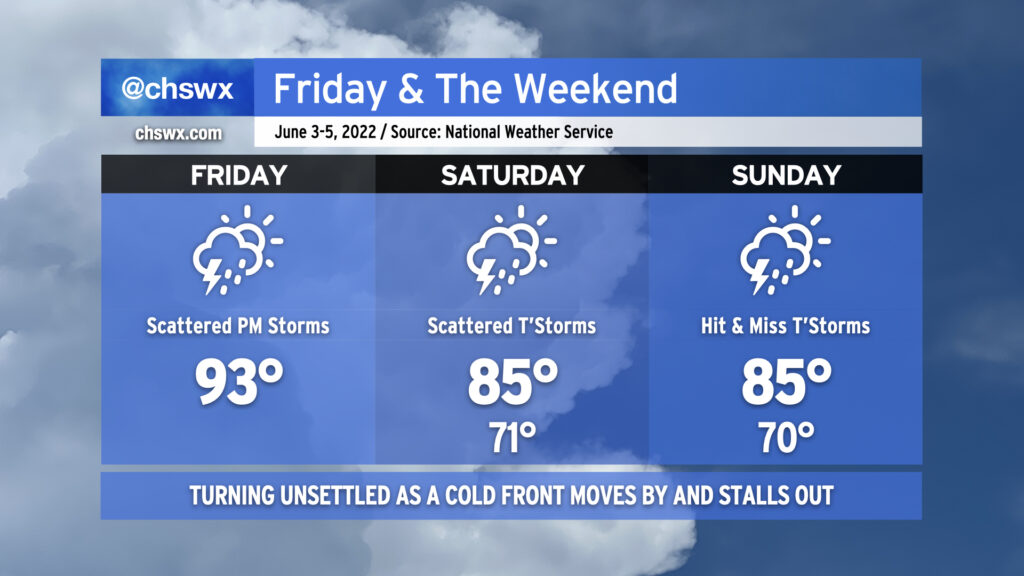
We have one more fairly hot day in store before a cold front moves into the area later tonight, bringing with it some unsettled weather — perhaps a strong thunderstorm or two — before moving through and stalling out to our southeast, keeping rain chances in play for the weekend (though turning a little better by Sunday).
Today will start as the past few days have, with temperatures heading into the 90s by early afternoon. Around 2-3 PM, we should start to see showers and thunderstorms fire on the seabreeze — perhaps as close to the coast as the US-17 corridor — before gradually moving inland with time. At the same time, we’ll be watching the cold front to our north and west continue to press into the Carolinas. With the seabreeze, other colliding outflow boundaries, and the approaching front, a couple storms could turn strong to severe, particularly inland. Damaging wind gusts are the primary concern.
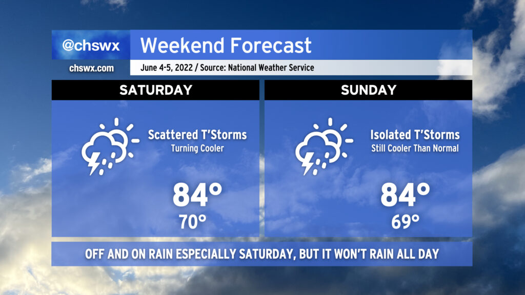
The convection-allowing models hint at a lull in the activity this evening before the front gets through the area, perhaps spreading some showers and a few thunderstorms into the area after midnight. Once the front gets through, we will feel somewhat cooler temperatures for the weekend courtesy of winds turning east and northeast as high pressure wedges in from the north. Winds could be a little breezy thanks to a pressure gradient between the aforementioned high pressure and what is expected to be Tropical Storm Alex as it passes well to our south. Alex could also help bring some additional moisture into the area particularly on Saturday, which will keep shower and thunderstorm chances elevated throughout the day (though the highest in the afternoon with daytime heating). By Sunday, the atmosphere dries out a little, but a few hit or miss showers and thunderstorms remain possible into the early evening.
Bottom line for your weekend: It won’t rain all day at any one particular location, but have that rain plan ready to go for any outdoor activities, particularly on Saturday when the probability of precipitation is higher. (And enjoy the cooler temperatures!)
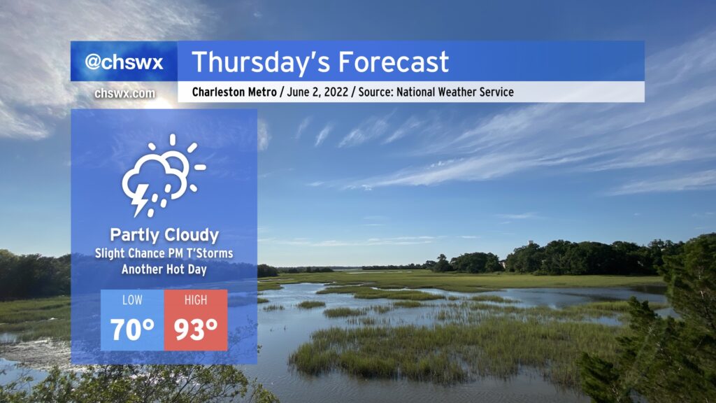
Another hot day is in store for Thursday as highs once again soar into the 90s under partly cloudy skies. Add humidity in, and heat indices could reach 96-97°. There’s a slight chance of a popup thunderstorm or two tomorrow, but the vast majority of us once again look to remain rain-free. If storms do fire, they could produce some gusty winds, heavy rain, and cloud-to-ground lightning, so be ready to move indoors if you’ve got outdoor plans tomorrow afternoon.
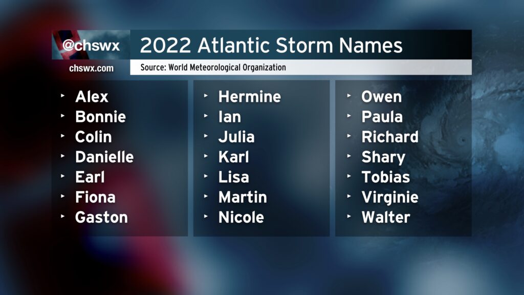
Well, friends, here we are again: It’s the first day of the Atlantic hurricane season. For the first time since 2014, we begin June with the full slate of names as there were no named May storms. (We’ll see what NHC ultimately does with low pressure that came ashore around Pensacola about a week ago in its postseason analysis, though. It looked awfully tropical.)
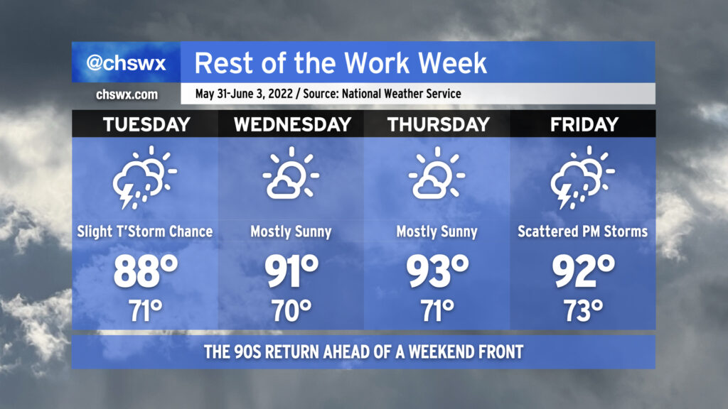
Stop me if you thought today was Monday — yes, it is indeed Tuesday — which means we’re already getting into the midpoint of the work week. And as we begin June and meteorological summer, the weather will certainly cooperate with summer-like conditions. Expect warmer-than-normal temperatures to dominate into Friday, with highs in the low 90s expected each afternoon. Factor in humidity, and it’ll feel closer to the mid-90s, especially right after the seabreeze comes through.
We’ll see a slight chance of afternoon thunderstorms each day as the aforementioned seabreeze moves inland, but the vast majority of us should stay rain free through Friday as these storms will be extremely hit-or-miss. We’ll start to see a little uptick in shower activity on Friday as a front approaches the area, but the better rain chances (for now) will be found Saturday morning as the front gets through.
We’ll also be keeping an eye on the tropics, where an area of disturbed weather (the former Hurricane Agatha in the eastern Pacific) could form into a tropical depression as it approaches western Florida later this week. It’s far too soon to know what this means in our neck of the woods, but this looks to be a decent rainstorm for at least some parts of Florida. Depending on the track, we could see some marine impacts and maybe even some tidal flooding over the weekend. The first name on the list for the 2022 season is Alex. I don’t think this is going to be a major issue for us (if it even becomes much of one at all), but will watch it all the same. Just about that time of year, after all.
We’re headed back to the 90s as we head back to work and, for the last week this year, school. We’ll see a chance for isolated to scattered showers and thunderstorms along and ahead of the seabreeze on Tuesday, with chances starting near the coast around noon-ish, then migrating inland for the rest of the afternoon. Not everyone sees storms. Expect highs to top out in the upper 80s.
As drier air filters in aloft, we’ll have less cloud cover, less of a shot at afternoon thunderstorms, and thus better opportunities to reach the low 90s each afternoon Wednesday and Thursday. A front will get closer to the area on Friday; compressional heating ahead of the front should send us back to the 90s in the afternoon but with a greater risk of afternoon and evening showers and thunderstorms.
Peeking toward the weekend, it appears the front is going to stall out and hang around. This, combined with an infusion of tropical moisture from the south, could keep the weekend somewhat unsettled. With the front by and high pressure wedging southward, though, we should run a few degrees cooler than we have been as of late (mid-80s as opposed to low 90s). We’ll keep a close eye on this as time goes on for fine-tuning.
In any event — stay cool and keep on watering for at least the next few days as moderate drought continues across the Lowcountry.
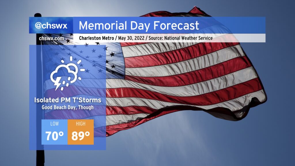
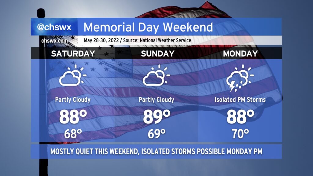
Memorial Day across the Lowcountry, while not nearly as springlike as last year’s, will feel appropriate as the unofficial start of summer. We’ll start the day in the low 70s away from the locally warmer coastline, heading into the upper 80s to near 90° away from the beaches by afternoon before the seabreeze rolls through. Temperatures at the beaches will top out in the low to mid-80s, making for a really good day to get some sun. (Just mind the high UV index and apply sunscreen liberally!)
There’s a tiny chance we could see a shower or storm in the morning as a little energy ripples on by, but that risk is rather low. The better — albeit still slight, all things considered — chance for showers and maybe a thunderstorm comes in the afternoon as we reach peak heating along and ahead of the seabreeze. Winds are onshore throughout a good bit of the atmosphere as surface high pressure remains offshore and a 585-588 decameter ridge remains centered over eastern North Carolina, so this should allow for the seabreeze to make good movement inland throughout the afternoon, limiting the risk for any thunderstorms near the beaches especially after 2PM. With limited to no wind shear to work with, thunderstorms will be pulse in nature and thus pop and subsequently collapse. All this to say, though, that the risk of any one location seeing storms is quite low — just be sure to have an indoor backup plan in case it’s needed briefly. Remember: When thunder roars, go indoors!
Temperatures will fall into the mid-70s in the evening, and any showers should be long gone by the time Nduduzo Makhathini takes the Cistern stage at Spoleto tomorrow night.
Finally, don’t forget to take a pause tomorrow to honor those we’ve lost in combat and their families. That’s why a lot of us are off, after all.
Memorial Day weekend in the Lowcountry looks quite seasonable — highs in the upper 80s, lows in the upper 60s, and partly cloudy skies for Saturday and Sunday as a front stalls offshore, but far enough offshore to keep us in some nicer weather. Indeed, we should stay mostly rain-free for the long weekend, though there will be a chance for a few isolated afternoon thunderstorms Monday as a little more moisture begins to work back into the area. All in all, though, things are looking pretty good to get outside.