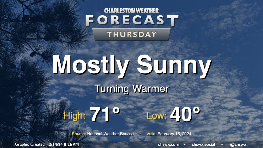
We got close to 70° on Wednesday, but we should reach it on Thursday with another day of mostly sunny skies under the influence of high pressure. We start the day around 40° and warm quickly to the upper 60s by midday, and will likely peak in the low 70s during the early part of the afternoon. Winds will shift to the southwest and will pick up a little in the afternoon, with speeds around 10 MPH becoming common later in the day.
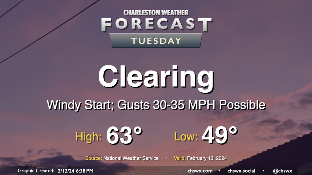
The storm system that’s soaked us on Monday will lift away from the area on Tuesday, clearing us out but also producing a period of gusty winds overnight as high pressure starts to build in from the west. Watch for gusts 30-35 MPH at times, especially on bridges and overpasses, that will affect the area through the morning commute. We should see gusts calm down gradually as the day goes on, thankfully. Clouds will depart and temperatures will warm to the low-to-mid-60s after an upper 40s start, yielding a pleasant and seasonable mid-February day.
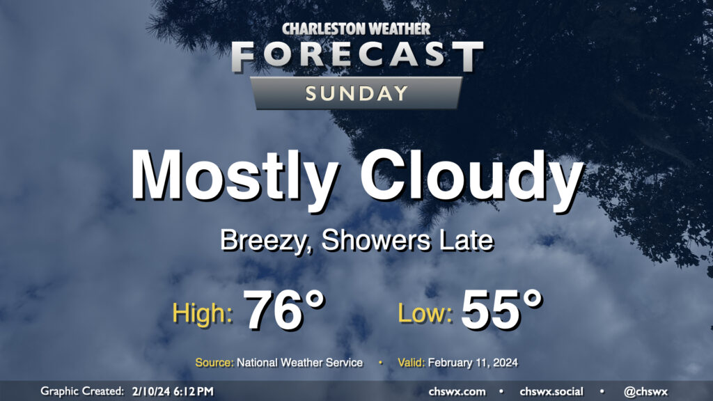
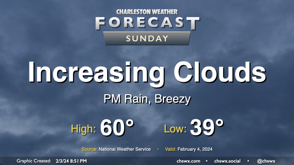
Sunday will be one last warm and largely rain-free day before shower chances arrive in the evening. Temperatures Sunday start in the mid-50s — 10°+ above normal for this point in the year — and head to the mid-70s as warmer and more moist air continues to surge into the area ahead of a storm system approaching from the west. Skies will remain mostly cloudy, though a few breaks in the clouds will still be possible especially in the morning.
By evening, we should start to see some shower activity begin to move in from the west. Guidance increasingly suggests that the best chance for showers Sunday will be found later in the evening and generally inland of 17-A. That being said, it looks like we get much of Sunday in without precipitation; just be ready for some rain as you head to and from any Super Bowl plans you may have.
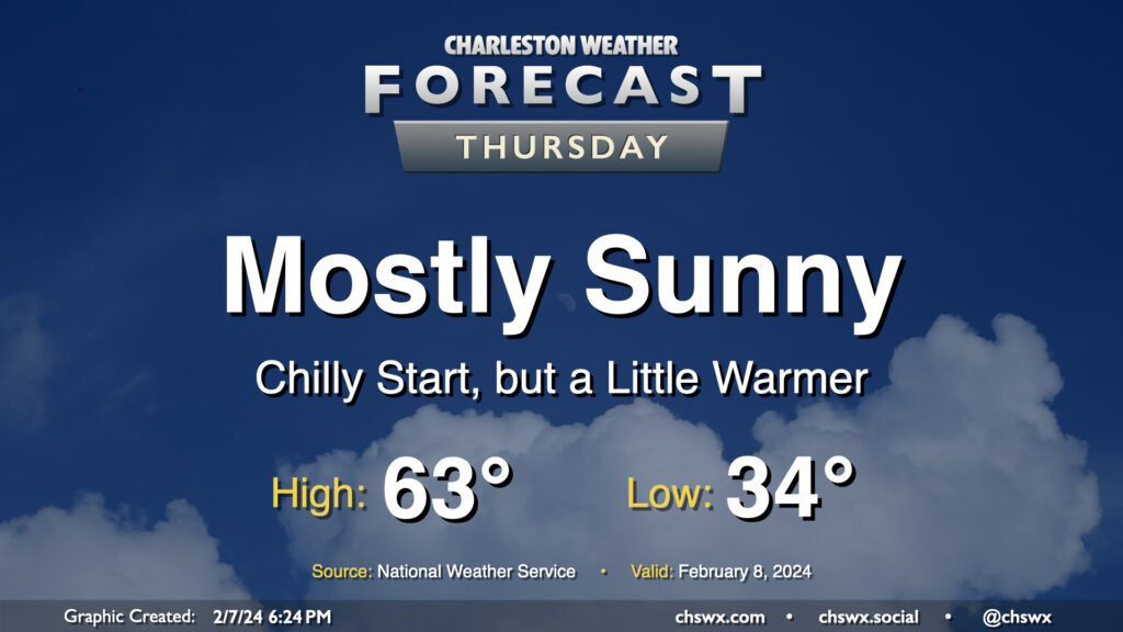
We have another chilly start ahead on Thursday as lows drop to the low-to-mid-30s across much of the metro one more time as high pressure moves overhead. We’ll see mostly sunny skies for a fair bit of Thursday before high pressure begins to slip further offshore and cloud cover starts to increase later in the day. Temperatures will show signs of a subtle warming trend as we top out in the low to mid-60s Thursday afternoon, a few degrees warmer than we have been the past couple days. Overall, it’ll end up being a fairly climatologically typical February day after the cooler-than-normal start.
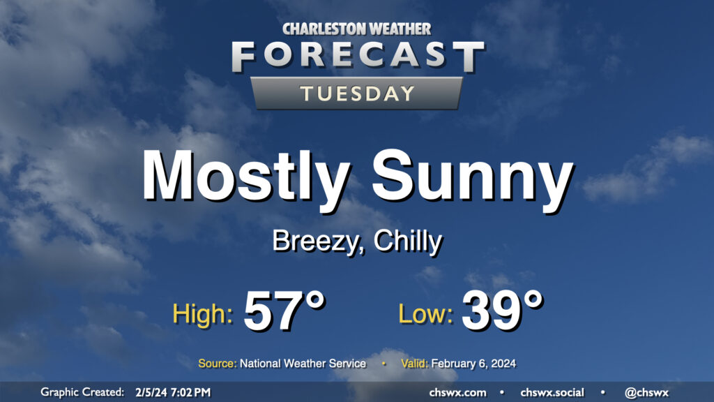
Showers have ended and cloud cover will diminish overnight, yielding a sunny Tuesday — in stark contrast to the dreariness that was Monday. However, high pressure trying to build in from the west will help to keep the gradient pinched as low pressure remains offshore, keeping north to northeast winds elevated throughout the day. Temperatures will start in the upper 30s, but the wind chill will make it feel more like 30°, so dress appropriately in the morning. We’ll warm only to the mid-to-upper 50s despite the sunshine, too.
The other issue for Tuesday will be the risk for some minor to moderate coastal flooding very early Tuesday morning. High tide around 4:32am is forecast to reach between 7.5-7.7′. While we fell just short of coastal flood criteria Monday morning, it certainly seems more likely that we’ll achieve flood stage on Tuesday. So, if you have early travels that take you downtown, be ready to reroute around flooded roads.
Our run of quiet weather comes to a brief pause starting Sunday as a storm system approaches the area. We’ll see cloud cover head up throughout the day, and showers will be increasingly possible as we get into the later afternoon and evening hours. Expect temperatures to start in the upper 30s to around 40°, with highs topping out around 60°. Northeasterly winds around the storm system will be increasing as the day goes on, and it could be a bit gusty by afternoon, so keep that in mind as well as you head out and about.
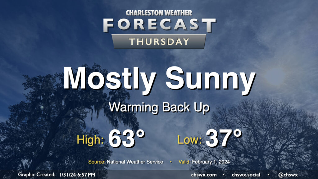
The sun comes back out on Thursday with the upper low long gone, and this leads to a nice warmup for Thursday. After starting the day in the mid-to-upper 30s, we’ll warm to the low-to-mid-60s for the start of February. Overall, no major weather concerns to kick off the month, and that ain’t bad.
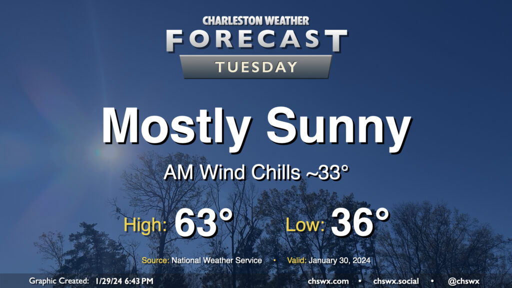
Expect another seasonally-appropriate day on Tuesday, though we will start out a little cooler than we did on Monday. Lows should bottom out in the mid-30s, and with a little wind still blowing, it’ll feel a few degrees cooler. Temperatures should head to the low-to-mid-60s under mostly sunny skies. Winds will shift southerly and pick up a bit in the afternoon ahead of a weak low, nudging dewpoints up a few degrees but certainly nothing outrageous.
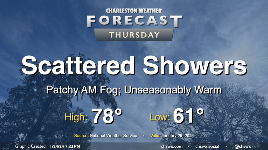
We hit 77° at the airport on Wednesday, narrowly missing a record high by two degrees (79°, set in 1950 and tied in 1974) and making this the warmest day so far in this young year. We have a chance to top that on Thursday despite showers working their way into the area as we stay within the broad warm sector of a storm system in the mid-South. We should start the day with some patchy fog as lows fall to the low 60s, right around the normal high for this point in the year. Temperatures will then warm to the upper 70s, and there’s a more-than-decent shot that some spots reach 80°. (The record high for January 25 is 82°, set in 1949.) A few showers will be possible across the area during the day, but coverage should be relatively sparse.
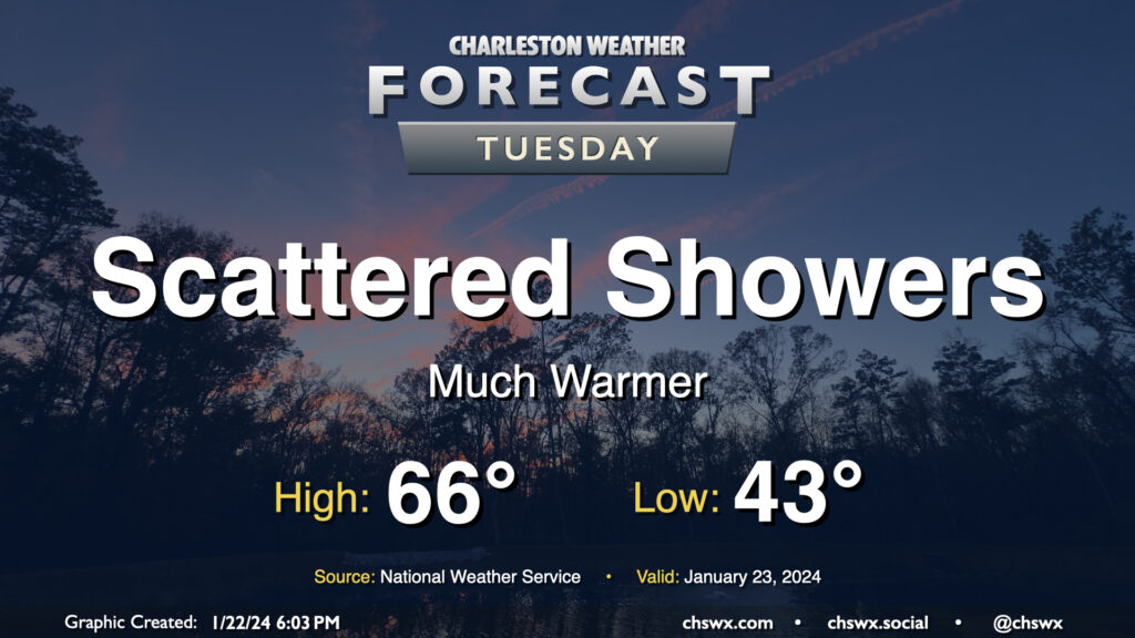
After a day in which we warmed up some 14° compared to Sunday with a high of 60° at the airport, the warming trend continues for Tuesday and beyond as surface high pressure continues to move offshore. Temperatures on Tuesday start in the low-to-mid-40s — roughly where we were for a high on Sunday — and warm into the mid-60s in the afternoon under mostly cloudy skies. A few showers will be possible at times, but any rain will be generally light. Still, y’all know how traffic can get even with the lightest of rain, so prepare accordingly.