Forecast for Thursday, February 7. First 80°+ day of the year!
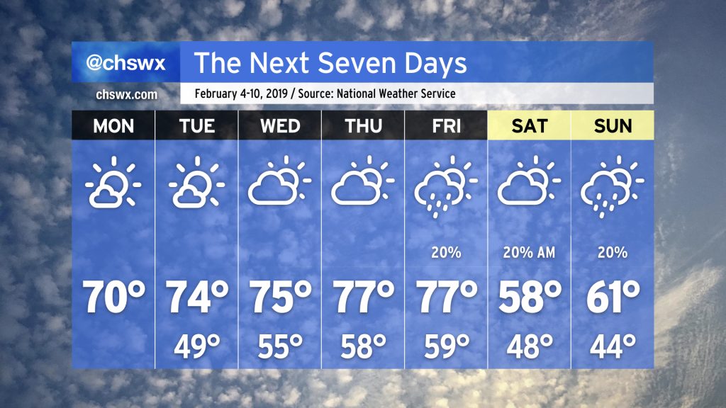
The warmest day of #FakeSpring is upon us, with highs expected to top out in the low 80s away from the beaches, which will remain much cooler under the influence of water temperatures in the 50s. The NWS forecast high of 81° would be a new record for the date.
Record warmth looks to continue through Friday. Even if records aren’t set, temperatures will push 20° above normal for this time of year.
Our February “heat wave” continues for the rest of the work week as high pressure at the surface and aloft continues to be in control of our weather. Changes are in store for the weekend, though.
National Weather Service forecast for February 4-10, 2019. Rather warm!
Warm weather fans are going to like what is in store for the upcoming work week as subtropical ridging takes shape over the Gulf of Mexico, driving the storm track and cooler air to our north for a few days.
National Weather Service forecast for January 30, 2019. Cold!
We are getting off to a rather chilly start this morning on the southern periphery of a significant Arctic blast of cold air. While we may be starting in the upper 20s, at least we are in the upper 20s above zero — can’t say the same for our friends in the Upper Midwest.
GOES-East infrared satellite depicting an Arctic front draped from the Gulf of Mexico north to the Great Lakes. Areas of blues in the Dakotas, Minnesota, and Wisconsin are not clouds — those are just frigid temperatures!
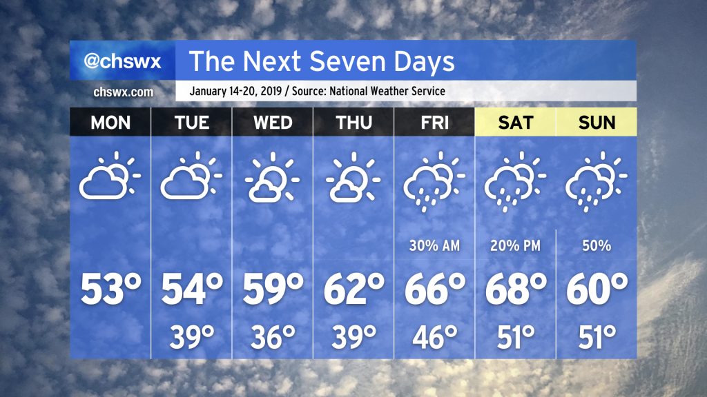
We’ve got some rain headed our way this afternoon into early this evening, followed by another round of chilly temperatures. Temperatures look to bounce back to close out the work week, though.
Seven-day forecast from the National Weather Service in Charleston.
We will be closing January with another Arctic cold snap making its way across the eastern half of the U.S. We won’t be immune from this cold snap, but it will not be a terribly severe or long-lasting cold for us in Charleston.
Seven-day forecast from the National Weather Service. Chilly start, but it gets warmer as the week progresses. Next rain chances by Friday and the weekend. (Sorry.)
The latter half of January looks to usher in a more unsettled pattern that seems reminiscent of December, at least in its timing: Unsettled weekends followed by mostly dry (and occasionally chilly) work weeks. Indeed, that’s how this week looks to go down.
Three-day forecast from the National Weather Service in Charleston, updated at 3 PM on January 10. Chilly weather continues into Sunday before a wedge of high pressure lifts northward.
We’ve been fortunate to catch a bit of a break from the wet weather over the last few days. Unfortunately, this respite looks to come to an end this weekend as a storm system approaches from the west.