Showers and maybe a thunderstorm will be accompanying a cold front tonight into tomorrow morning. There could be some brief pockets of heavy rain and gusty winds, but no severe weather is expected.
The front will get through around daybreak or so Friday morning. Persistent cloud cover and cold air moving in will limit highs to the low 60s. Showers become possible once again later into the evening hours as low pressure develops to our northeast; any rain, if it does end up falling, should be relatively light.
As low pressure departs, skies will clear and temperatures will tumble. Expect to wake up to mid-30s on Saturday morning, with highs struggling to 50° in the afternoon despite full sunshine. Subfreezing temperatures are expected Sunday morning, with a few spots well inland perhaps dipping into the upper 20s. Full sunshine and some shortwave ridging aloft will help temperatures start to rebound a little in the afternoon, with highs in the mid-50s expected. We’ll return to the low 60s for Monday, and will be back in the 70s by Wednesday, so this cold spell won’t have much staying power — good news for warm weather fans, and not so much fun for the cool-inclined amongst us. But so it goes in the “cool season” during a La Niña year here in the Lowcountry.
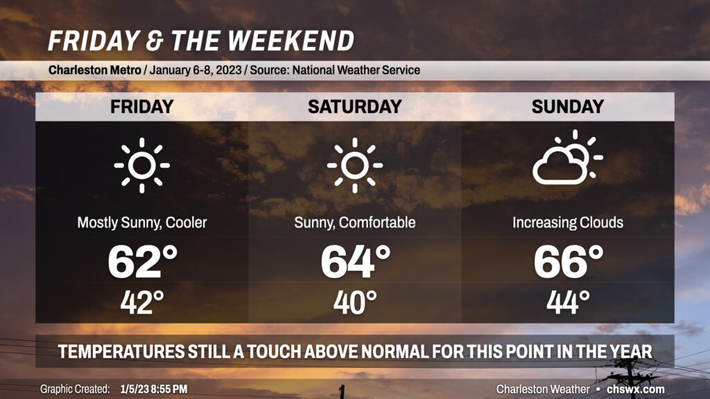
Friday and the weekend will feature quiet and comfortable weather for early January as cooler and drier air behind a cold front continues to filter in. Temperatures will still be running a click or two above normal, with highs in the low-to-mid-60s each day and lows generally in the low-to-mid-40s. Sunday looks to be the warmest of the three days as another cold front draws closer to the area, which could bring some rain chances late into Monday. Overall, our mild start to 2023 largely continues, and that ain’t bad.
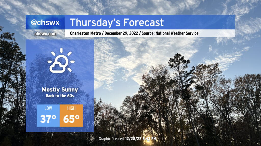
After a high of 62° today — the first time since December 17 that we’ve crossed the 60° threshold — we will be back into the 60s tomorrow across the metro, with temperatures running a few degrees warmer than they did today. Most notably, those of us east of Highway 17-A will remain above freezing into tomorrow morning for the first time since December 23. Those of you along and inland of 17-A will want to take freezing weather precautions for just one more night as lows dip below 32° for a time, with a few upper 20s possible in more sheltered locations. However, many of us will not need to drip faucets or take other precautions tonight (though bringing your pets in is always a good idea this time of year).
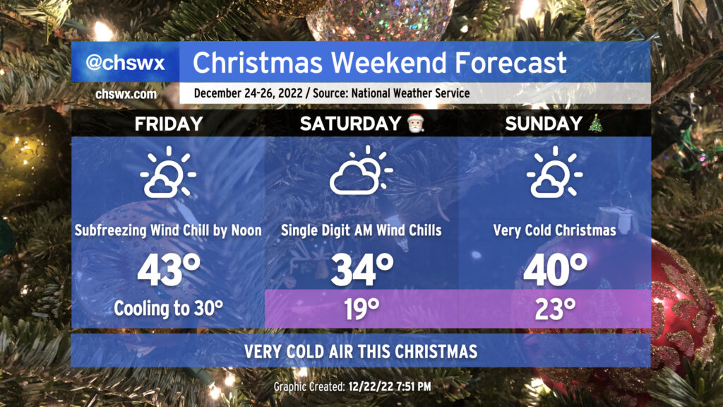
A very potent cold front will be coming through early Friday, bringing strong, gusty winds, dangerous wind chills, and several mornings in a row of pipe-busting cold for the Christmas holiday weekend.
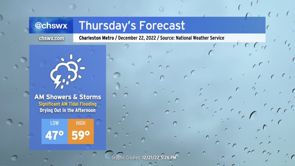
Thursday will bring somewhat complex weather to the Lowcountry with a very soggy start to the day as low pressure moves across the area, followed by a dry slot moving into the area in the afternoon to shut off the rain. Of course, we continue to monitor the progress of an incredibly potent Arctic cold front as it progresses across the country, with it expected to clear our area on Friday.
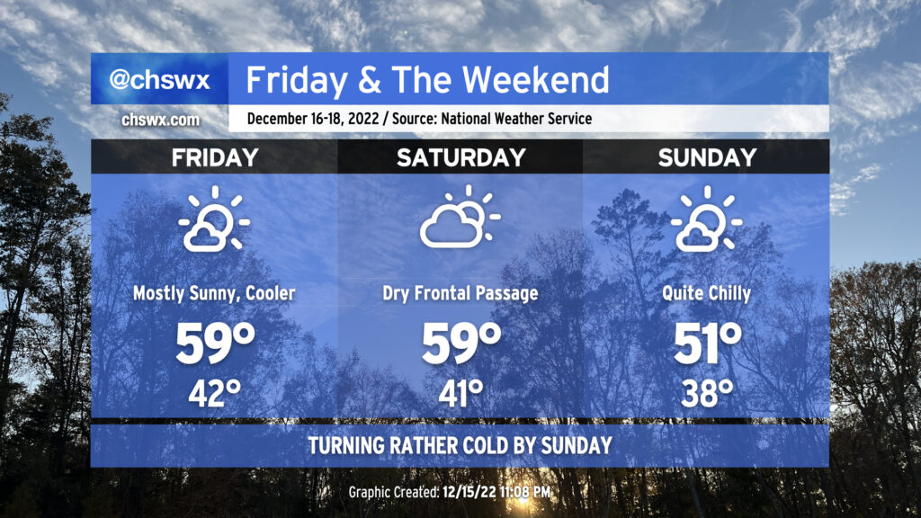
We have a rain-free Friday and the weekend on tap as high pressure generally takes control. It’ll be noticeably cooler as we start Friday in the low 40s on our way to highs in the upper 50s to around 60° with mostly sunny skies. Expect similar temperatures for Saturday with increasing cloud cover in the afternoon as a reinforcing shot of cold air pushes through the area. (There will be too much dry air for precipitation with this front, though.) That’ll lead us to a rather chilly Sunday by any measure — lows in the upper 30s run on the cold side of normal for this point in the year, but the expected high of 51° is cold for our neck of the woods by any measure, and even moreso when you consider that we’ll have almost full sunshine! Suffice to say, it’ll be an excellent weekend for hoodies and sweaters of varying degrees of ugliness.
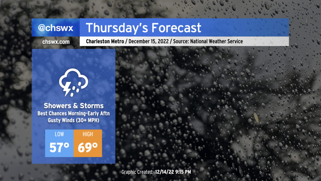
A warm front is lifting north across Georgia and South Carolina this evening, which will make for a warmer and more muggy day for Thursday ahead of a cold front. I’d anticipate that the forecast morning low of 57° will be set closer to midnight, followed by temperatures heading into the 60s by daybreak, topping out around 70° in the afternoon. Gusty winds will precede the front even outside of any thunderstorms — watch for gusts 30-35 MPH to potentially cause some havoc with Christmas decorations. We can expect a few showers and maybe even a thunderstorm or two overnight into the morning ahead of the main frontal band.
The timing of the front and the extent of morning shower activity will act as a governor on any severe weather threat that could develop. Shear looks good, but instability is the question mark. Still, a few storms with gusty straight-line winds are possible, and there’s even the risk for a few of these storms to rotate. Keep an eye on the weather Thursday, particularly mid-morning through early afternoon, for any possible watches or warnings that might need to be issued.
We should be rid of the rain by evening — some of the faster guidance coming in this evening even has it out of here by mid-afternoon, with some sunshine breaking out before the day’s over — with temperatures falling into the 50s by 8 PM as cooler and drier air moves in behind the cold front.
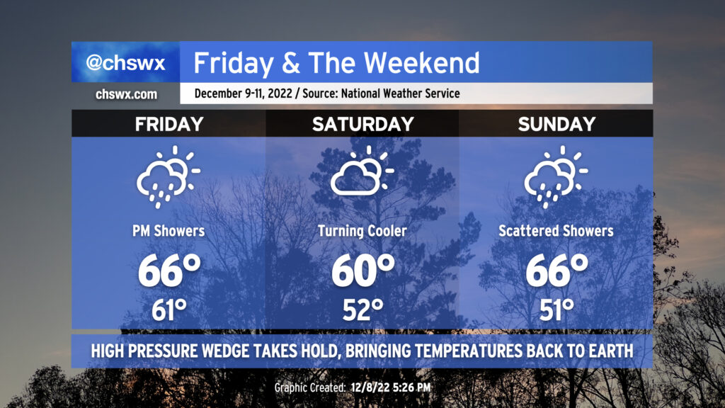
Alas: Gray days are here again for the weekend as a wedge of high pressure drives southward across the area on Friday. We’ll see a few showers push through the area Friday morning as the wedge settles in, then more moisture will move by in the afternoon to bring another round of generally light rain. Temperatures won’t move too much beyond the morning low of 61°, with highs only in the mid-60s anticipated as cooler air moves in throughout the day (and rainfall into the wedge helps reinforce said wedge).
We’ll have a lull in the rain on Saturday, but high temperatures will generally run below normal under mostly cloudy skies, with the air struggling to warm to 60° in the afternoon. Then, another round of showers will roll through Sunday. We should see the wedge erode on Sunday as another front approaches from the north, but the degree to which this happens during the day makes the temperature forecast interesting. For now, mid-60s are in the forecast for the Charleston metro, but don’t be surprised to see this revised lower with later updates. I also wouldn’t be surprised for temperatures to not make it out of the 50s further north into Berkeley County around the Francis Marion and Lake Moultrie. Stay tuned!
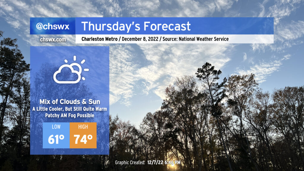
After tying a record high on Wednesday (81°!), we’ll see a cold front approach our area for Thursday. The associated cloud cover will help prevent us from getting back to record warmth, but we’ll still see highs peak in the mid-70s — perhaps higher if the front struggles to get further south. We should remain rain-free, however.
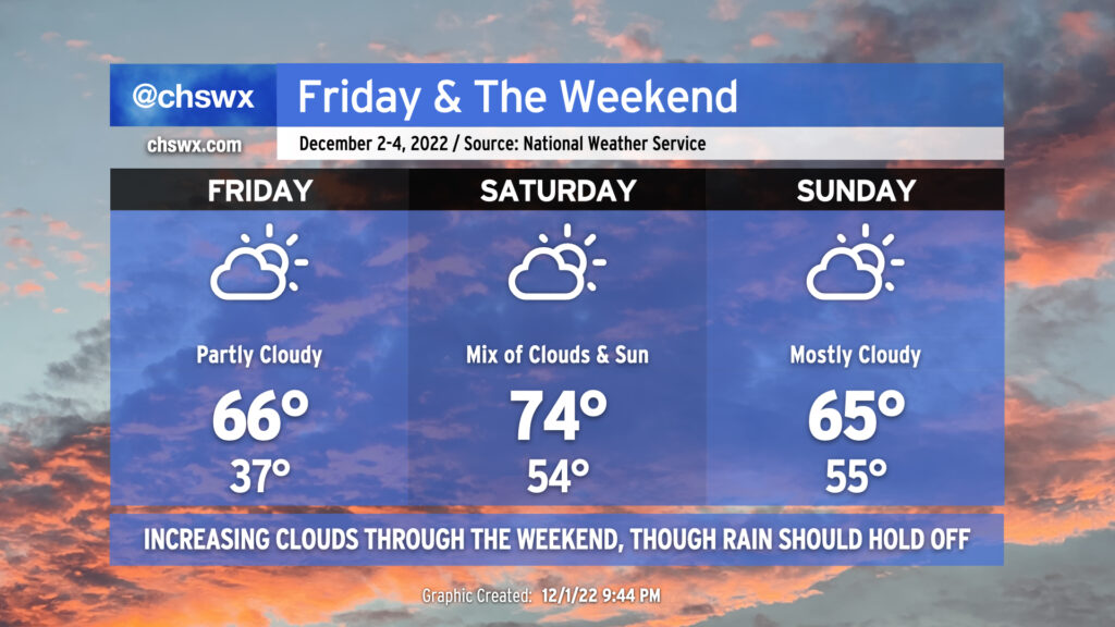
We’ll see a mix of clouds and sun this weekend with a bit of a temperature rollercoaster as a front looks to sag south of the area on Sunday.
Friday will bring a very chilly start — lows in the mid-30s across much of the metro, with colder temperatures perhaps approaching freezing in some spots. Light northeast winds will make it feel a few degrees cooler, too. (Make sure pets and plants are inside tonight.) Highs in the afternoon will rebound to the mid-60s, about 5° or so warmer than we saw on Thursday. Expect scattered to broken cloud cover.
Saturday will turn warmer ahead of the aforementioned front, as highs will peak in the mid-70s. We’ll see a mix of clouds and sun continue with showers generally dissipating before they arrive.
The front should sag south of the area by Sunday, knocking temperatures back down about 10° in the afternoon with highs only peaking in the mid-60s. Showers are unlikely, though we’ll want to keep an eye out Sunday night given some model disagreement. That being said, the bulk of the weekend should get in generally rain-free, and while we might want to see more in the way of sunshine, it won’t be too bad at all.