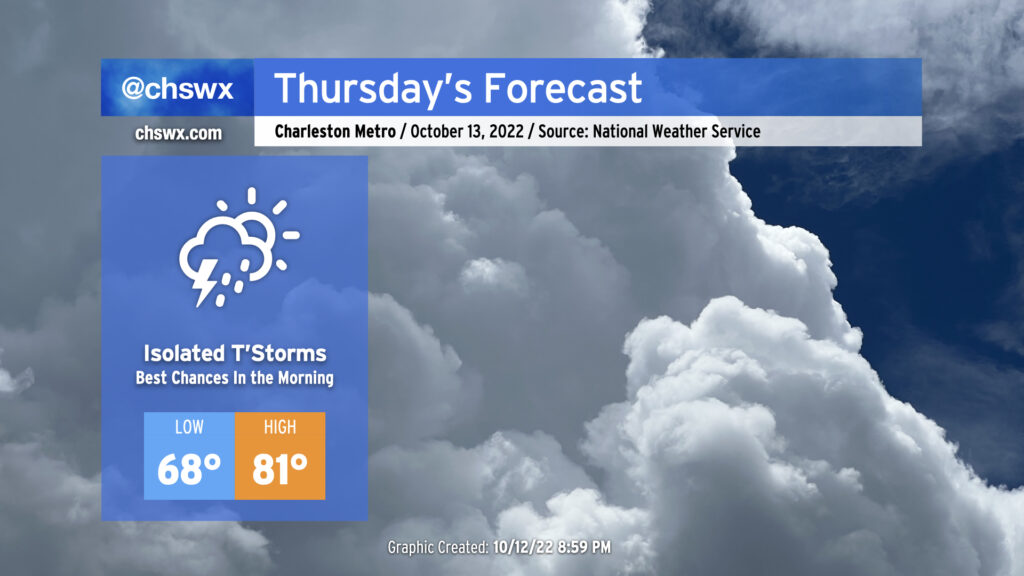
Overnight showers and thunderstorms will begin to taper off as we head toward daybreak Thursday. We may deal with some slick roads in the morning, though, so be ready for that possibility for your commute. The good news: We’re done with the recent round of tidal flooding induced by the full moon and onshore winds, so no concerns there.
The cold front will be moving through the state throughout the day and won’t clear the area until after sunset Thursday. Ahead of the front, a few showers and thunderstorms could redevelop as temperatures recover into the low 80s in the afternoon. Drier air punching into the area will modulate that threat somewhat, but don’t be surprised to see a shower or storm in your neck of the woods in the afternoon.
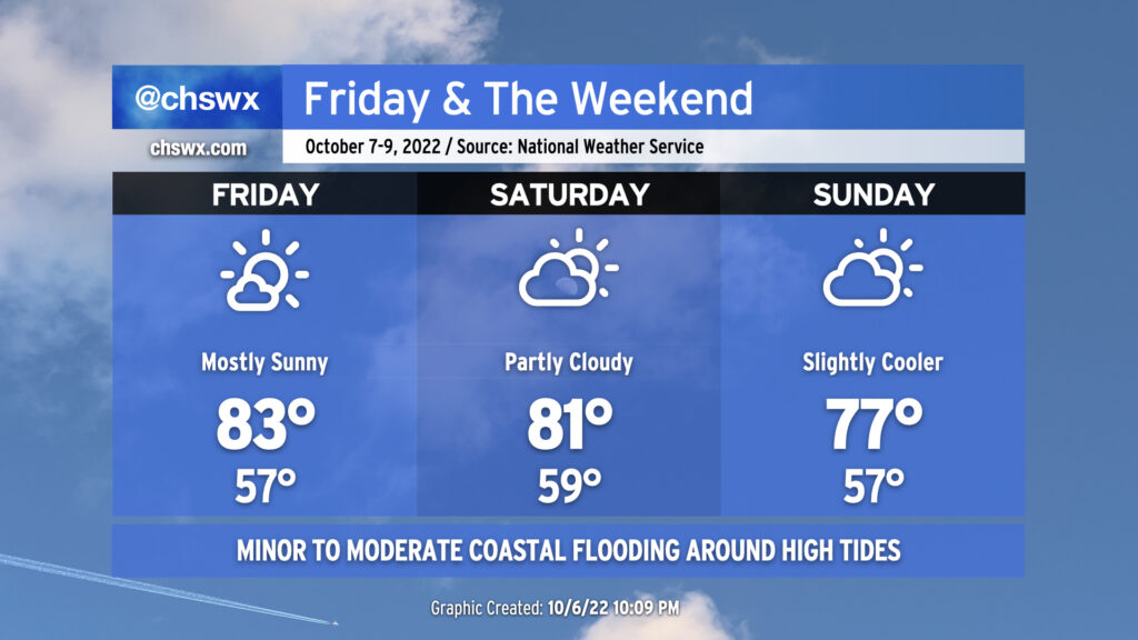
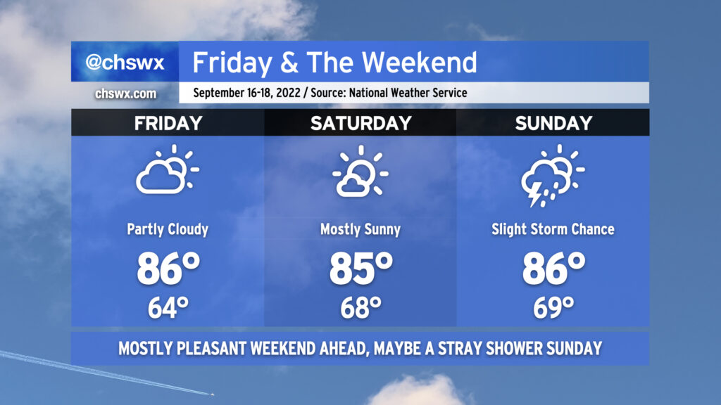
We stay seasonably warm for Friday & the weekend, even with a cold front swinging through later Saturday. Friday’s going to be the warmest day of the set with the most unencumbered sunshine and some compressional heating ahead of the cold front helping to drive highs to around the low to mid-80s. A few more clouds will mark the approach and passage of the front Saturday, but no rain is expected; expect temperatures back in the low 80s ahead of the front Saturday afternoon. Winds go northeasterly on Sunday and will help to cool things down a touch. Expect highs to run in the upper 70s, generally a few clicks below early-to-mid-October normals, but not quite the chill we saw in the immediate wake of Ian last week.
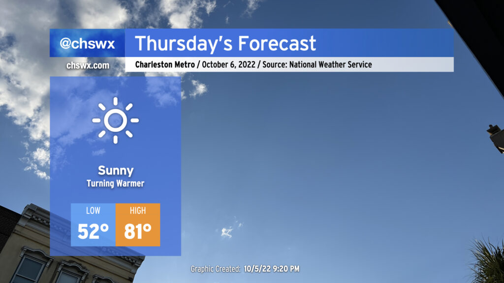
Thursday will be another nice weather day across the area with a seasonable chill to start and comfortable warmth to finish. Lows will once again start in the low-to-mid-50s away from the warmer coastline, but plentiful and virtually unobscured sunshine combined with winds generally out of the southwest will help temperatures reach the low 80s in the afternoon, right on the nose for early-October climatology. Should be a nice day for getting out and about!
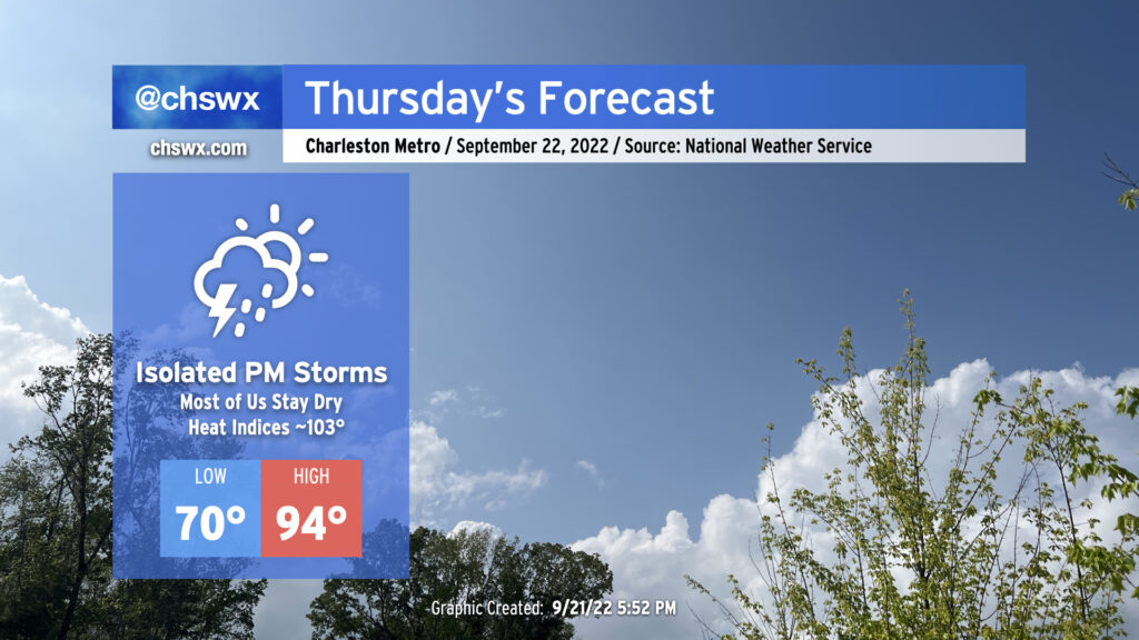
We’ve got one more hot day in store for Thursday before the weather takes a turn for the fantastic for Friday and the weekend. Compressional heating ahead of a cold front will drive highs into the mid-90s for Thursday afternoon, perhaps approaching the record high of 96° set in 1990 at the airport. Downtown could very well tie or break the record high of 92° set in 1925, too. Mix in a little bit of humidity and it’ll feel closer to the upper 90s (though heat indices should stay south of 100° as the deep-layer dry air helps to mix out dewpoints to the mid-60s). There will be a slight chance of showers and thunderstorms in the late afternoon and early evening hours as the front passes by, but don’t expect anything too heinous as there’s still plenty of dry air to overcome for much in the way of active weather.
We’ve got a much nicer-looking weekend ahead than we had last weekend as a few more days of comfortable temperatures and generally quiet weather continue across the area. Partly cloudy to mostly sunny skies will generally be the rule each day. We start Friday back in the mid-60s for one more day before dewpoints begin to creep up heading into the weekend, nudging lows up to the upper 60s for Saturday and Sunday. Highs, though, will remain in the mid-80s — right at normal for this point in the year.
Sunday’s looking like the only day that could see a little shower and storm activity. A wave of low pressure is expected to form along a stationary front well to our south, with a coastal trough developing on its northern flank. This may be enough to push a few showers and storms inland from the Atlantic, but rain chances are slight at best; many of us should stay rain-free. Otherwise, though, quiet weather looks to persist well into next week as ridging develops aloft. Temperatures will warm a bit more under this ridge, and it’ll feel a touch more humid with dewpoints climbing to around 70° beginning Saturday night and Sunday, but rain chances remain next-to-nothing heading into next week. (We’ll take all the drying out we can get.)
Well, today was supposed to feature a lull in the shower and storm action, with more isolated coverage…and then it rained for five hours, flooding downtown Charleston again while 3-5″ of rain dumped on Johns Island and West Ashley. This was due to the combination of a stalled front and outflow from a thunderstorm cluster that developed to our northwest. Add in a little upper-level energy and you have a very, very soggy Thursday afternoon. Thankfully, the bulk of today’s rain is over and we should largely dry out overnight (though with fog a distinct possibility).
As we head into Friday, scattered storms remain in the forecast as the ever-present front remains close by. The impact on our weather will largely be driven by how far south it slips tonight into tomorrow. Right now, the expectation is that the greatest concentration of storms will be to our south and west, but I do anticipate that we’ll see a few more downpours tomorrow across the metro area, perhaps again having impacts on the evening commute.
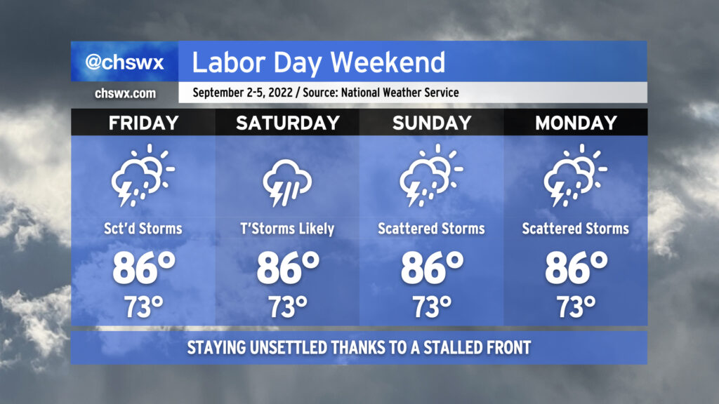
Shower and storm coverage is expected to tick up a little bit more Saturday as onshore flow becomes a little more convergent at the surface. That’ll be the day with the greatest potential for persistent rainfall (at least as currently forecast). There is a little model disagreement with where the surface front will be, though, and so that’ll drive a little uncertainty. Heading into Sunday and Labor Day, rain chances continue to persist, with scattered coverage expected as a coastal trough develops and hangs around. This doesn’t look to be a full-day washout for Labor Day, but be ready to move outdoor activities inside.
With the persistent risk of scattered storms and the ensuing cloud cover, highs should stay in the mid-80s each day after starting in the lower 70s. This is around, if not a touch below, early September normals.
The pattern looks to stay generally unsettled heading into the last weekend of August, though some subtle changes will help reduce coverage at least a little on Saturday and Sunday.
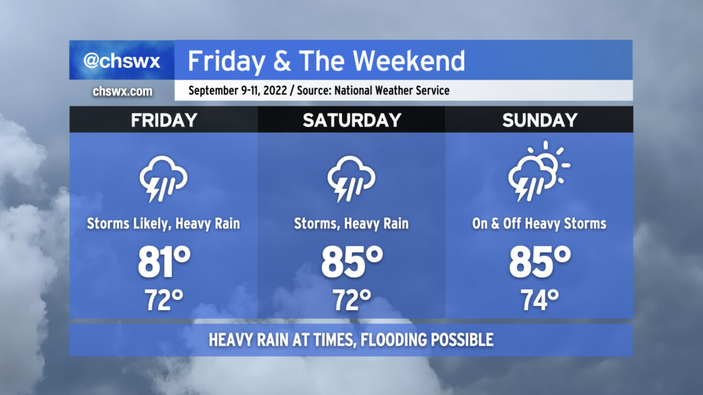
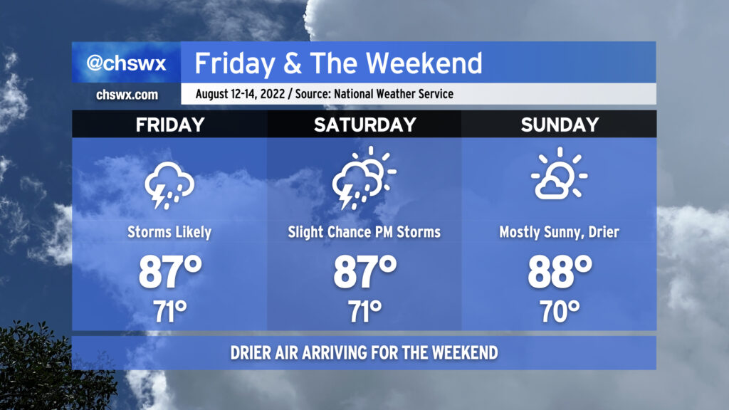
Showers and thunderstorms remain likely particularly Friday afternoon and evening as a front remains stalled just offshore and energy aloft pivots into the area. We continue the risk for heavy rain with precipitable water values well in excess of 2″ expected to persist — plenty of moisture for deep convection to wring out. Watch for ponding of water on roads or even isolated bouts of flooding.
Slightly drier air will then poke in from the north on Saturday into Sunday. This should have the effect of scattering out shower coverage a little bit more, particularly on Saturday. However, the area won’t totally get off scot-free when it comes to rain this weekend, so be sure your outdoor plans have an indoor backup just in case.
Temperatures will remain a few clicks below normal for late August as cloud cover and rainfall stick around. Generally, we should expect lows in the low 70s each morning (running a little warmer near the coast thanks to warm sea-surface temperatures) followed by highs in the mid-80s in the afternoons.
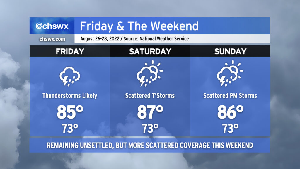
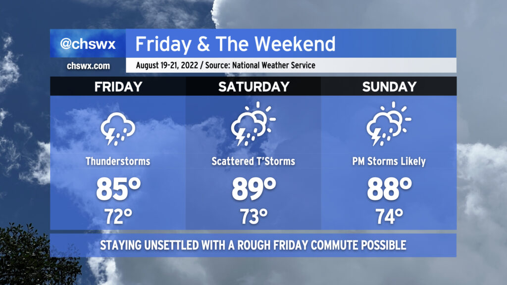
Unsettled weather will continue this weekend as the lingering front remains a thorn in our side. Friday morning could be a particularly tricky commute as there’s the potential for some heavy rain to be moving through the area around that time. Fortunately, the commute will coincide with low tide, but whenever we’re talking heavy rain we’ll want to keep an eye on the vulnerable areas, such as downtown Charleston, Summerville, and West Ashley near Church Creek (to name a few). Showers and thunderstorms will lift north of the area with the front as the day goes on, but more storms should fire in the afternoon as the seabreeze gets going. Temperatures will generally run in the mid-80s.
With the front having lifted north, warmer weather returns to the area for the weekend. Temperatures top out in the upper 80s to around 90° on Saturday with scattered thunderstorms developing along and ahead of the seabreeze, possibly starting as early as the late morning hours. On Sunday, we’ll stay unsettled with scattered showers and thunderstorms expected particularly in the afternoon and evening hours, when storms could turn a little more numerous. Highs once again will top out in the upper 80s. Overall, not the best weekend of weather, but there will be dry times, too — rarely, if ever, do we see total washout days in the summer.
A cold front will push southward across the area on Friday, likely bringing with it showers and storms especially in the afternoon and evening hours. The convection-allowing models generally agree on some sort of linear storm organization pushing southward into the area tomorrow evening; the greater question is whether storms will fire ahead of it as well. I’d be prepared for periods of unsettled weather throughout the day, and be ready for another commute impacted by showers and thunderstorms. A severe storm or two can’t be totally ruled out, but the main concern will be heavy rainfall and frequent lightning. Cloud cover and rain showers should help keep highs suppressed to the mid-and-upper 80s.
The front will move south of the area and stall out on Saturday, switching winds around to the northeast and beginning to usher in some cooler and drier air the likes of which we haven’t seen since late June. Dewpoints will fall into the mid-60s and cloud cover will scour out somewhat. However, there’s still a slight chance for showers and thunderstorms in the afternoon hours as a wave of low pressure develops along the front. If that wave develops nearby (as tonight’s NAM 3km suggests), it could spread some moisture ashore. That aside, Saturday should actually feel really terrific, especially further inland. Same for Sunday, where partly cloudy skies and mid-60s dewpoints will persist, making for another comfortably warm day across the Lowcountry.
Onshore winds and the recent full moon at perigee could contribute to water levels approaching minor flood stage with the Saturday evening high tide. So far, I’m not expecting any major tidal flooding issues, but it always bears watching with northeasterly wind directions near a full moon.