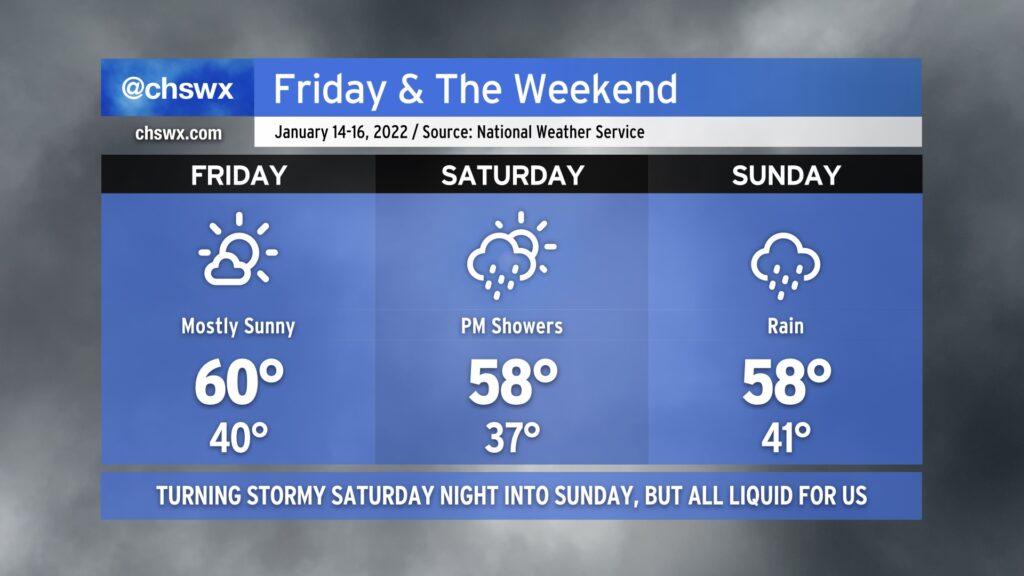
Let’s start with the good news: Friday looks pretty good, with highs around 60° in the afternoon under mostly sunny skies. Much of Saturday looks to be okay as well, with showers not expected to start until later in the afternoon/early evening. And then there’s Sunday.
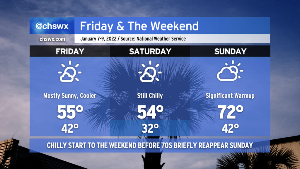
After a couple slightly warmer days, a reinforcing shot of cooler air arrives for Friday into Saturday. Highs will once again top out in the mid-50s both days despite plenty of sunshine. A freeze is even likely for most of us away from the coast on Saturday morning, too. By Sunday, though, high pressure quickly slips offshore and the southerly return flow turns the heat pump back on, sending us into the low 70s in the afternoon ahead of an advancing cold front. There could be some shower chances late Sunday, but the best risk of rain right now appears to be overnight Sunday into Monday morning as the front swings through. All in all, not a bad-looking weekend with a little something for both cool-weather and warm-weather fans.
Additionally, tomorrow should be only the second time this year that we will not have any coastal flooding concerns in Charleston Harbor. Water levels once again peaked just over 7′ this morning, making it 5 of 6 days so far in 2022 with some tidal flooding to contend with. (The one day there was no flooding? Monday, when the windstorm blew the tide out well below predicted levels.)
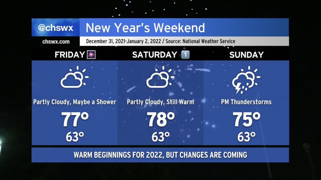
After some much-needed rain (and some lesser-needed hail) on Thursday, we head into New Year’s Eve with continued warm temperatures as a frontal boundary, which has caused some complications for the weather in the southeastern US this week, remains stalled well to our north. A shower or two can’t totally be ruled out Friday, but much of us should remain dry to close out 2021, and fireworks displays should be unimpeded as a result. Temperatures will once again head well into the 70s in the afternoon, and could challenge the record high of 78° last set in 1996.
New Year’s Day will remain quite warm with a mix of sun and clouds. Highs should stay just shy of the record of 80° we set on January 1, 2021, but they will certainly get close as we remain within the warm sector. Saturday should remain rain-free for the Lowcountry with no appreciable disturbances to speak of to instigate shower activity in our neck of the woods.
The pattern will finally begin to change on Sunday as a potent upper-level system dislodges the stalled front and finally pushes it eastward. Expect showers and even a few thunderstorms ahead of the cold front Sunday afternoon and evening. A few storms could be on the strong side given good upper-level support and probably just enough instability. Highs top out in the mid-70s owing to cloud cover and rain chances. There’s still questions on when the front ultimately gets through, but all indications are that the first Monday of 2022 will be significantly cooler than we’ve experienced in the past couple weeks! Hang in there, cool weather fans — almost there.
Record high temperatures will be possible Friday and Saturday as deep southerly flow pumps a lot of warm air into the area ahead of a cold front currently timed to get through here on Sunday.
We’ll start Friday with some patches of fog in the area giving way to a mix of clouds & sun. A sprinkle or two can’t totally be ruled out, either. The forecast high of 78° would tie the record high set in 1971, and a low of 59° would tie the record high minimum temperature set in 2012. We’ll certainly be on record watch throughout the day!
Saturday may also approach record warmth despite a little more cloud cover. The record high for December 18 is 80°, set in 2008. Once again, we may start the day with some patches of fog.
By Sunday, though, a cold front will be getting through the area, capping temperatures to around 70° with a scattering of showers becoming most likely from the late morning to early afternoon. Departing low pressure may kick up the winds a little bit, and could contribute to a threat of coastal flooding as we get into Monday. Thereafter, the next risk of rain arrives Tuesday as a coastal storm potentially scrapes the area. We’ve got plenty of weekend before we have to worry about that, though.
A cold front will approach the area tonight, bringing with it periods of cloud cover that will occasionally obscure the view of the partial lunar eclipse (beginning around 2:30am, peaking at 4am, and ending around 5:30am). However, given that much of this cloud cover will be higher-based, it could make for some rather dramatic photography even though the moon won’t be completely clear. Something to think about as you consider your plans tonight!
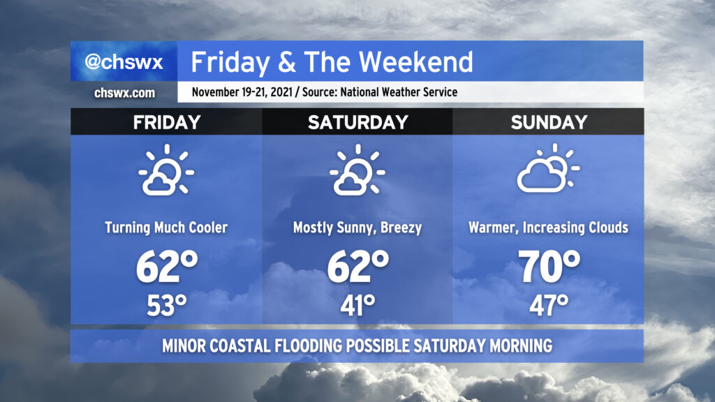
Said cold front moves through the area around daybreak Friday, and brings with it much cooler and drier air — expect highs to only top out in the low 60s despite mostly sunny skies. We’ll have more of the same on Saturday, with high pressure wedging southward a bit and kicking up northeasterly winds to yield wind chills in the low 30s in the morning before warming back to just the low 60s once more. High pressure will slip offshore quickly, though, and by Sunday we’ll feel warmer temperatures in the upper 60s to around 70° as return flow from the southwest increases ahead of another quite potent cold front that’ll swing through to kick off the abbreviated Thanksgiving work week. How potent, you ask? It may very well be enough to bring the season’s first freeze to inland locations. Highs could struggle to the low 50s next Tuesday if current forecasts pan out. Stay tuned!
There will be an outside shot at some minor coastal flooding Saturday morning given the winds shifting around to the northeast and the full moon helping to elevate astronomical tides somewhat. Right now, the forecast falls just short of the 7′ mean lower low water level that marks the coastal flooding threshold, but we’ll keep an eye on it. Thankfully, this will not be anywhere in the ballpark of the major flooding event we experienced a couple weekends ago, and the threat for coastal flooding will be relatively short-lived as winds promptly go offshore on Monday after frontal passage.
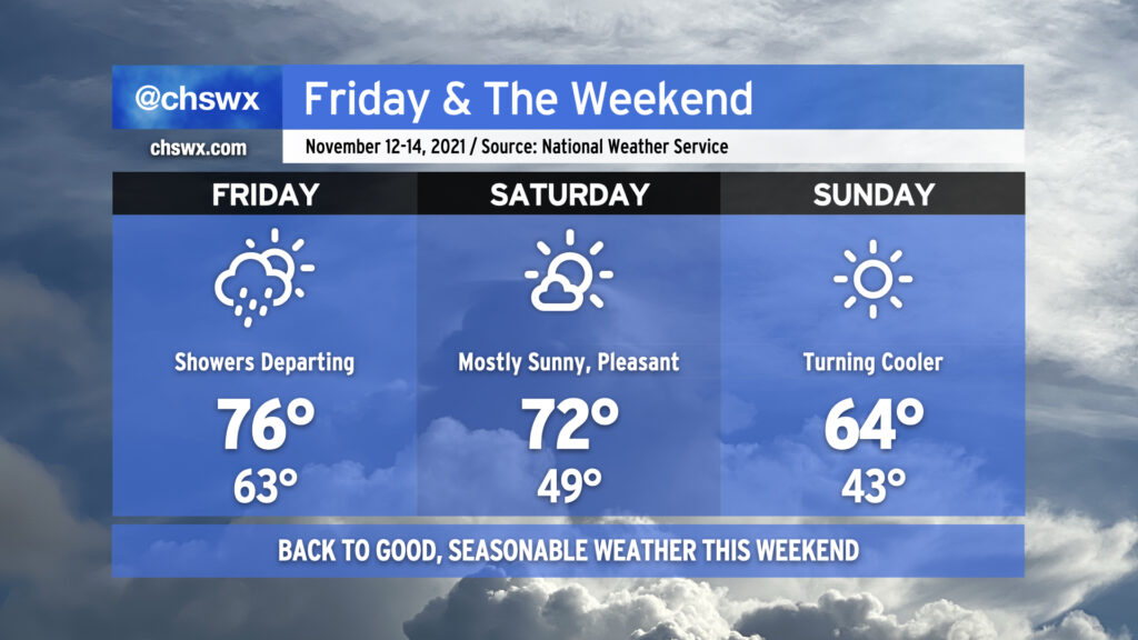
We’re back to nice weather this weekend as a series of dry cold fronts move through, reinforcing progressively cooler and drier air as time goes on. Any leftover showers should be departing with the front Friday morning, and despite frontal passage, we should still warm into the mid-70s but with lower dewpoints spreading into the area. Winds out of the west and northwest could have a little downslope component to them, which will aid in warming us a few degrees above normal for the afternoon.
Saturday looks excellent, with mostly sunny skies and temperatures around or just a hair above normal ahead of another front that looks to get through the area later in the evening. This front brings in another shot of cooler and drier air for Sunday, which certainly could prompt a sweater weather watch with highs in the mid-60s despite full sunshine. Overall, I would say this weekend’s weather will dramatically outclass the mess that was last weekend.
While we reached minor flood stage once again in the harbor early this afternoon — eight consecutive days of coastal flooding, for those of you counting at home — the risk for additional coastal flooding is extremely low going into Friday and virtually nonexistent heading into the weekend. (And thank goodness for that.)
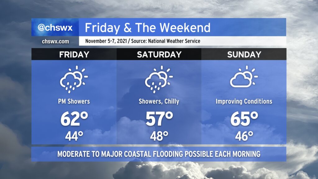
Much cooler than normal temperatures will persist for Friday into the weekend as a high pressure wedge remains in place, keeping north to northeasterly flow over the area through Sunday. As a coastal storm organizes offshore — how far offshore remains quite an important forecast question — we’ll see an uptick in rain chances beginning Friday evening into Saturday. Where the storm sets up will largely influence just how much rain we get, an important piece considering the specter of an 8’+ high tide on Saturday morning. If heavy rain coincides with that tide, what looks to already be a significant coastal flooding event gets that much worse.
The coastal storm will lift away from the area heading into Saturday night, and we should see some more sunshine on Sunday. Moderate to major flooding remains a threat with the Sunday morning high tide, though, and will need to be watched carefully. We’ll stay on the chilly side, too, with highs only topping out in the mid-60s — more January than November.
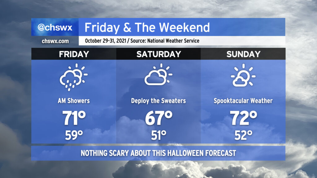
After some lingering showers clear the area Friday morning, we will head into the weekend with quite seasonable weather to close out October. Friday looks to be another breezy day across the area as low pressure in the Tennessee Valley lumbers northeastward. A shower or two can’t be totally ruled out in spots on Friday afternoon, but the chances are relatively small. Same for Saturday, as a mix of sun and clouds keeps highs in the mid-to-upper 60s across the area with a stray shower or two possible (but unlikely). Expect more sun for Halloween as high pressure begins to reassert itself a little bit and drier air takes hold over the area. Trick-or-treating will be in fine shape (weather-wise, at least). Be safe and enjoy!
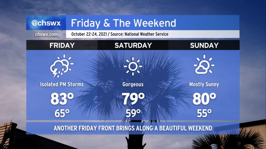
We’ve got more excellent weather on the way for this weekend, but first, we deal with a weak cold front on Friday. A few showers and storms could pop off in the afternoon ahead of said front before it swings through, but the vast majority of us look to stay dry. Expect warmer-than-normal temperatures, especially in the morning where we get started in the mid-60s away from the warmer coast and top out in the low-to-mid-80s in the afternoon.
Once the front is through, another area of dry high pressure works into the area. Saturday looks extremely good, starting out in the mid-to-upper 50s with highs topping out shy of 80°. After another cool start in the mid-50s, Sunday will warm to around 80-81° under mostly sunny skies. Enjoy!
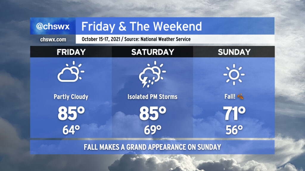
After a record high was tied at Downtown Charleston today (85°, last set in 1975) and records could be challenged on Friday (87° at the airport, last set in 2018), a cold front will knock us solidly into more autumnal weather starting Sunday. We’ll start Friday in the mid-60s (near the low 70s closer to the coast) with temperatures warming into the mid-to-upper 80s in the afternoon, challenging the aforementioned record, with mostly sunny to partly cloudy skies persisting.
Saturday will be it for the 80s for at least a few days as the cold front approaches the area. The incoming front could help spark off a few afternoon and evening showers and thunderstorms, but severe weather — much less widespread heavy rainfall — is highly unlikely.
The front will come through overnight Saturday, and by Sunday morning, it’ll feel a lot different — temperatures will be in the mid-50s away from the coast to start the day, and will only warm up to the low 70s at best in the afternoon under clear skies. We’ll keep this fall feel for at least the first part of next week, too. Get those hoodies ready!