We are breezy but rain-free this evening as dry high pressure remains in control of our weather. It will hang on for a bit for the first part of Thursday, but a gradual deterioration in weather will begin in the afternoon. It’s a good time to finish gathering supplies for a rough period of weather beginning later Thursday through Saturday morning.
A vigorous complex of showers and thunderstorms will traverse the Southeast tomorrow, arriving here in the Lowcountry around early evening with a risk of damaging wind gusts and a tornado or two.
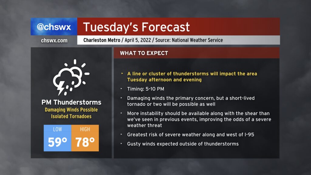
Tuesday’s severe weather potential has a little different feel in that there’s a good chance more instability will be available ahead of the line, as it should be coming through right in that sweet spot time of 5-10 PM or so. (Stay tuned for inevitable tweaks to exact timings as the storm system gets underway.) Wind shear is plentiful, on the order of 50-60 knots, and if thunderstorm updrafts can take advantage of instability rooted in the surface, there will be plenty of available energy for strong to severe thunderstorms. (More on this in a sec, though.) Despite expected cloud cover, the heat pump is on, and warm and moist air will flow into the area readily during the day, allowing for highs near 80°. Winds outside of thunderstorms will once again be gusty as well, with gusts 30+ MPH not out of the question particularly on elevated surfaces.
Damaging straight-line wind gusts are certainly the main concern, with probabilities high enough to drive an Enhanced (level 3 out of 5) risk in tomorrow’s severe weather outlook. However, tornadoes will be possible with any discrete storms as well as embedded within a squall line (if that ends up being the storm mode).
There are possible failure modes here, though. Forecast soundings from this evening’s models do show some capping trying to hold across the Charleston metro with an inversion a few thousand feet up and dry air entrainment trying to put a damper on an even more unstable environment. This could act as a governor on a more substantially widespread severe threat. We can’t bank on this, though, especially as wind shear remains strong enough to keep thunderstorm updrafts healthy.
Bottom line: Be ready for possible watches and warnings tomorrow. Keep weather radios in the alerting position and phones charged. Know what you’ll do if a warning is issued for your area. If you live in a mobile home, be thinking carefully about where you’ll go if severe weather threatens. Damaging winds, tornadoes, and mobile homes can be a tragic mix. A site-built structure will give you more protection in situations like these.
With any luck, we’ll see another round of storms fizzle out as it reaches Charleston. But if that doesn’t happen, you’ll be glad you were prepared.
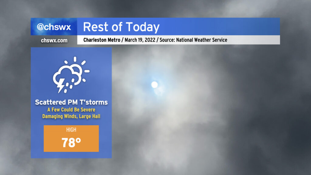
We’ve gotten off to a fairly benign start here in the Lowcountry, but that may change later today as a cold front approaches. Temperatures as of this writing are in the low 70s already with dewpoints in the low to mid-60s, pretty ripe for this time of year. Cloud cover has ticked up somewhat in part due to anvil blow-off from some thunderstorms already firing in southeast Georgia. Winds have also ticked up some, with a gust to 23 MPH recorded at the airport as of the 10am observation.
High temperatures across the Charleston metro should top out in the mid-to-upper 70s this afternoon before the cold front gets closer to the area. It’s this surface feature, currently moving across Georgia and into upstate South Carolina, which should provide the needed lift to allow for scattered thunderstorm development this afternoon. Wind shear and instability will not be lacking, and with some capping in place limiting more widespread development to start, storms could initially start off as supercells, increasing the severe weather threat. The strongest storms will be capable of damaging straight-line wind gusts and large hail. A tornado can’t be ruled out, particularly where storms interact with the seabreeze, which is forecast to be near the coast for much of the day. Given strong SW winds keeping the seabreeze pinned to the coast, it is unlikely that cooler waters will have a significant impact on storm strength.
Given the initially isolated nature of these thunderstorms and the timing of the cap breaking, it’s going to be very tough to pinpoint who exactly will see storms and when. General thinking, according to NWS, is that the greatest risk of thunderstorms will generally run between 3-9 PM. Trying to pin down too much more detail may be foolhardy without clairvoyance beyond what the science can provide.
Today’s advice is familiar: Stay close to reliable, redundant weather warning sources, one of which should not be your smartphone. NOAA Weather Radio and broadcast stations are two great ways to fulfill this recommendation. Not everyone will see severe weather today — perhaps, deity of your choice willing, none of us will! — but if it does threaten your location, you’ll want to be prepared to receive that warning and take action on it by having a safe space indoors, away from windows.
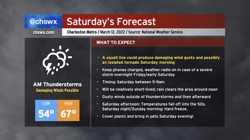
Saturday could be a bit of a wild day of weather across the Lowcountry. We’ll start with a strong cold front bringing a risk for strong to severe thunderstorms in the morning, and we’ll finish with Arctic air rushing into the area, leading to a hard freeze for many of us Sunday morning.
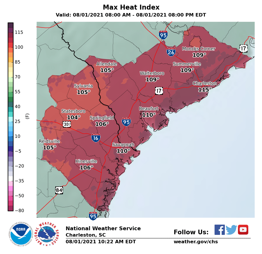
Temperatures will once again reach the mid-90s this afternoon across the area (fun fact: yesterday was the first 95° day all year at the airport). Combined with moisture-laden air characterized by dewpoints near 80°, this will once again drive the risk for excessive heat indices upwards of 115° near the coast, where an Excessive Heat Warning is in effect for today. For the inland counties, a Heat Advisory will be in effect with heat indices approaching 110°. Regardless of whether you are in the advisory or warning area today, you’ll want to take precautions against heat illness if you must be outside during the afternoon.
Showers and thunderstorms look to initiate a little later in the day than we saw yesterday, with the best risk of storms coming in the late afternoon and early evening hours. Models suggest a line of thunderstorms could develop and move across the area today. Timing is always a question mark, but I would be on guard for storms starting about 3-4 PM, with the earlier timeframe the further north and west you are. Available energy will be abundant with such strong surface heating and moist dewpoints. Thus, a few storms could be on the strong to severe side with damaging wind gusts, but frequent cloud-to-surface lightning and pockets of heavy rain remain the overwhelming concern from any storms that form this afternoon.
A cold front looks to get close to the area tonight. This will help shut off the oppressive heat of the last few days, but at the cost of another few days of on and off heavy, flooding rainfall. Will have more on the upcoming week later this evening.
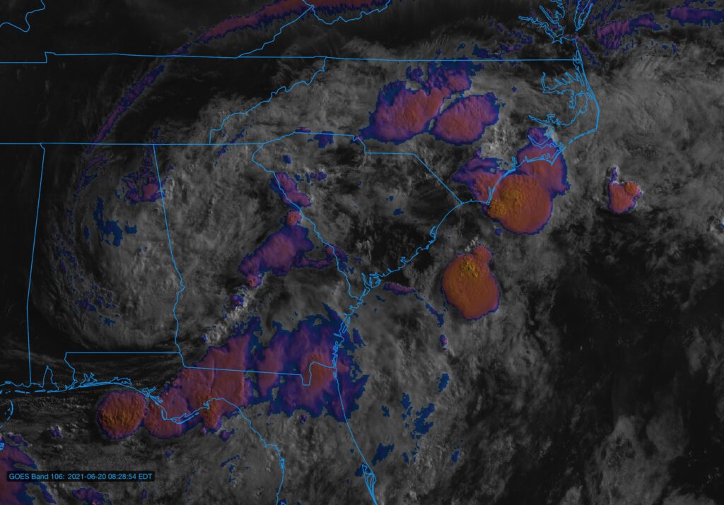
Visible/IR composite of Tropical Depression Claudette as of ~8:30am.
We will be watching the weather closely today as showers and thunderstorms develop and move across the Tri-County area on the southern flank of Tropical Depression Claudette. Heavy rain, damaging wind gusts, and even a tornado or two are all on the table. A Flash Flood Watch is in effect until 8am Monday, and it is conceivable that a tornado watch will be needed later today.
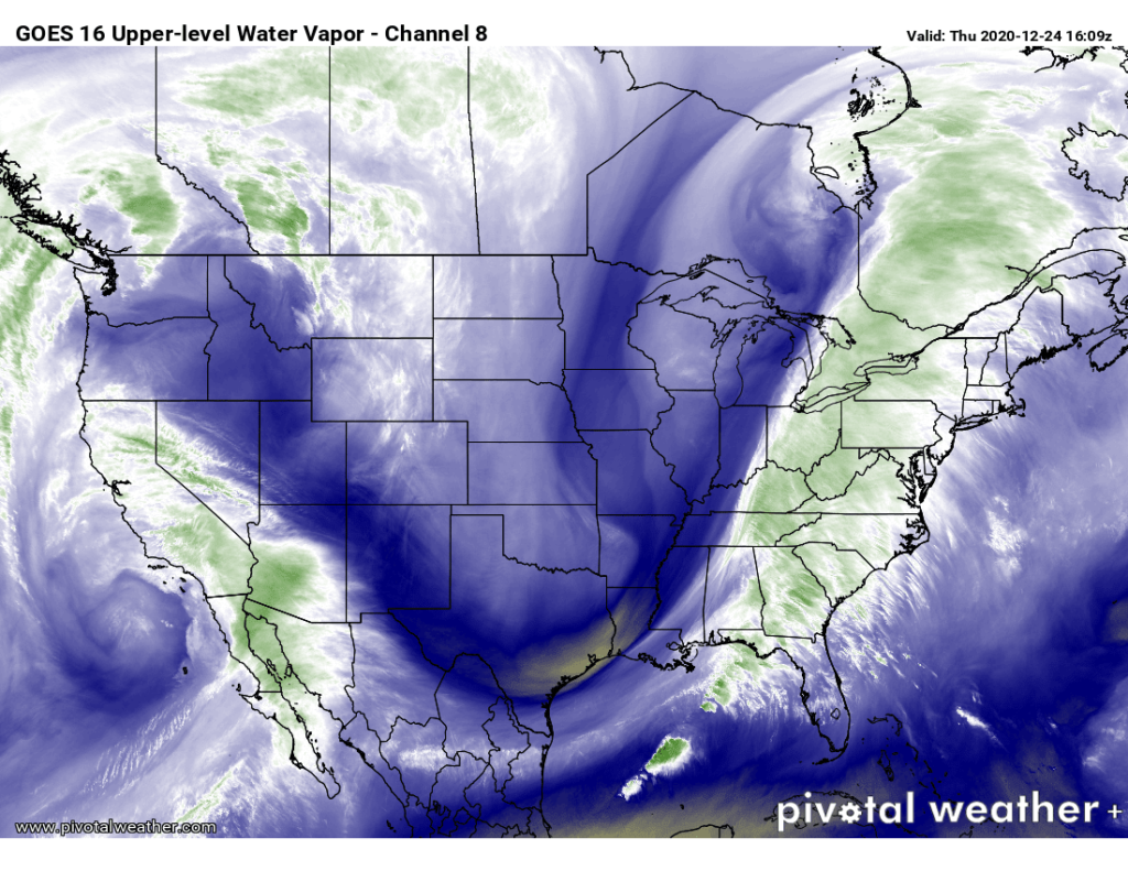
Water vapor imagery from GOES-16 shows the deep trough digging into the eastern half of the country, which will drive our weather this afternoon and evening.
We in #chswx continue to monitor the risk for strong to severe thunderstorms this afternoon and evening as a strong cold front driven by a highly amplified upper-air pattern makes its way to the coast.
Unfortunately, we’ll be needing to spend this Easter evening getting ready for a round of strong storms tomorrow morning. The severe weather threat for Monday is coming into focus, and there’s not been much change to the previous thinking: A line of strong to severe thunderstorms will push through the area during the morning hours. These thunderstorms will be moving into an atmosphere that is favorable for strong, damaging wind gusts (70 MPH possible, according to the National Weather Service), a few tornadoes (one or two of which could be fairly potent), and large hail.
What’s clear about Monday is that, at some point, there will be a squall line with strong thunderstorms coming through the area. These storms will be capable of producing wind damage and could spawn a tornado or two along the leading edge of the line.
The degree to which this threat will materialize is going to be highly dependent on timing, and that’s where it gets tricky — but I’ll do my best to demystify it.
A dry cold front will swing through tonight, bringing temperatures down well below normal for mid-April for Friday and Saturday, dipping into the low 40s by Saturday morning. High pressure will bring pleasant weather into the area to kick off Easter weekend, but that high pressure system will slide offshore Saturday evening, giving way to a potent storm system for Sunday and Monday.