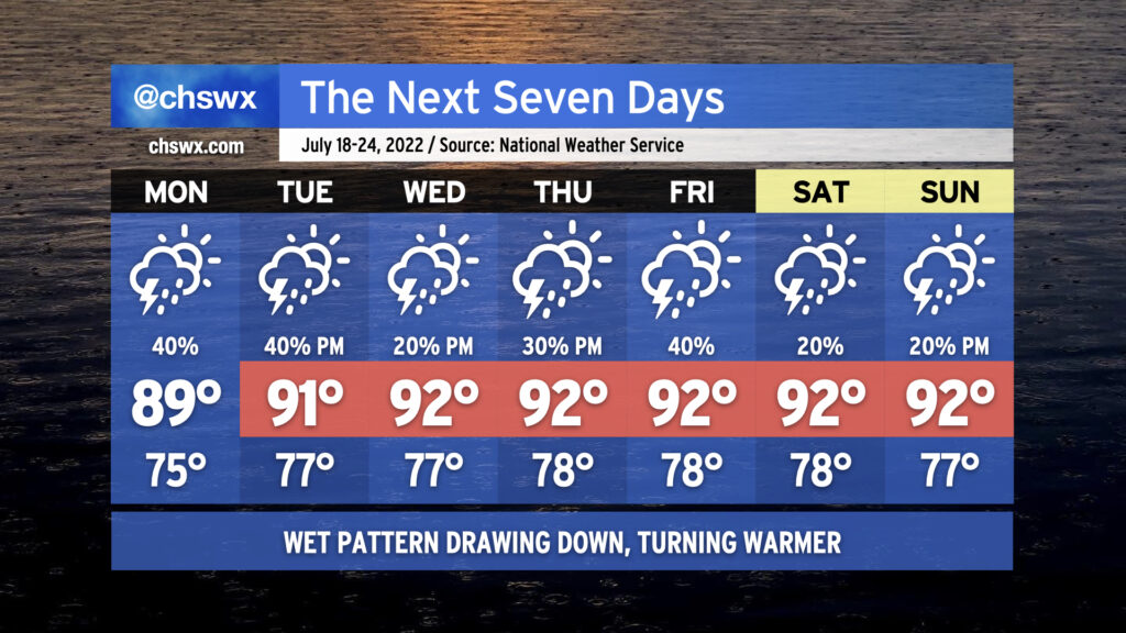
We will begin to see the widespread rain that’s punctuated the first half of July draw down a little bit this week as ridging aloft nudges back into the area. We’ve still got a couple days of periodic showers and thunderstorms to come, with another round of morning rain possibly in the cards for Monday, but overall the trend is a little drier. Of course, this is July, so nobody wins — we trend a little drier, and so temperatures trend a little more upward as the ridge builds overhead. Highs in the low 90s will be common, and with stifling humidity looking to continue, heat indices should be well into the 100s and may breach 105° several times this week. (The heat advisory criteria beginning July 1 is a heat index of 110° for two hours, so that’s why there’s no mention of Heat Advisories right now.) When storms do fire, they’ll be capable of dropping some heavy rain. Widespread severe weather isn’t expected, but you can never rule out a microburst or two this time of year. Overall, fairly standard mid-July fare is anticipated. Stay cool as best as you can — remember, frequent shaded breaks, lots of water.
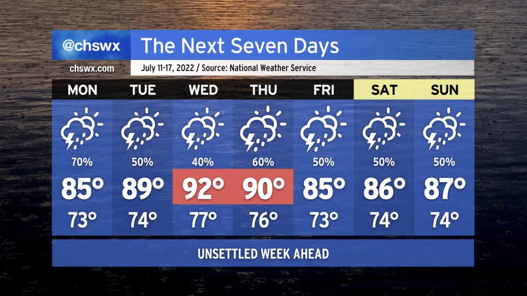
Showers and thunderstorms will continue to figure prominently in the forecast for much of the upcoming week. To start, we’ll continue to contend with the front that helped instigate today’s weather on Monday. Another bout of heavy rain is quite possible for some of us, which after 4-6” fell in some spots in the metro area today begins to seem excessive. We’ll want to keep an eye on a renewed risk for flooding on Monday as a result.
The front will wash out late Monday into early Tuesday, and as such, we’ll see a return to typical summertime form Tuesday and Wednesday. Temperatures will top out near 90° on Tuesday and in the low 90s Wednesday, with heat indices continuing to run around 100=105° given the continued humid airmass in place. Shower and storm chances in the afternoons will remain a little elevated as a result of said airmass.
Another front approaches later in the week, elevating rain chances again for Thursday and beyond. This will have the effect of keeping temperatures at or below normal, but it is also possible we might end up contending with more localized flooding due to heavy rainfall a distinct possibility. Keep an eye on forecast updates as we head toward later this week for that possibility.
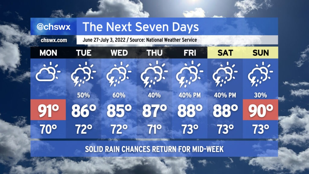
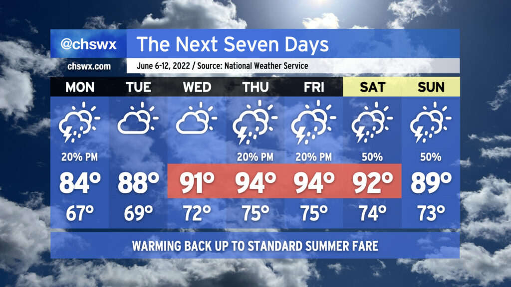
At Sunday dinner tonight, my mom remarked to me that her grass was getting awfully crunchy with the lack of rain. Fear not, Mom and others: Rain chances return to the forecast starting Tuesday and will continue for the next several days as a front presses into the area and stalls out. We could see some fairly heavy downpours at times as precipitable water values — essentially, the amount of water you could wring out of a column of air — approach 2″ across the area heading into Tuesday and Wednesday. The caveat, as always, is that it won’t rain all the time at any one location, and some locations will see more rain than others. (A few spots might even get shut out. Such is life in late June.) Once the front washes out and high pressure rebuilds heading toward the weekend, storms will be more scattered in nature, driven by typical daytime heating and forcing along the seabreeze. Overall, most spots can expect generally about 3/4″ of rain on average during the week with locally heavier amounts. It’s not going to bust the drought, but it should at least blunt it a little.
Cloud cover and thunderstorms will also help to keep temperatures down; below-normal temperatures are forecast for a good chunk of the week, in fact, with heat indices not really factoring in all that much especially on Tuesday and Wednesday. Monday will act as the high-mercury mark for the week, starting us in the low 90s before the front approaches and temperatures generally top out in the mid-to-upper 80s for the rest of the week. We could see another run at 90° for Sunday as the aforementioned high pressure settles back in, but all in all, welcoming July without oppressive heat and some beneficial rain isn’t all bad.
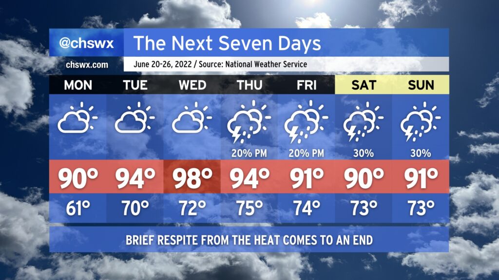
All good things must come to an end, and that includes our brief respite of below-normal temperatures that we’ve seen today. We do get one more crisp (by June standards) morning with lows bottoming out in the low 60s away from the immediate coast Monday morning. This will be followed by highs rising to around 90° in the afternoon. Thankfully, humidity will stay on the lower side to start the week as drier air remains firmly in place. Northwest flow around an anomalously strong ridge of high pressure will act to further dry out the atmosphere during the day, which will also help temperatures out to the mid-90s on Tuesday and the upper 90s on Wednesday thanks to compressional heating from downslope flow. The tempering of humidity will help keep heat indices from getting too far out of whack, but at the end of the day, the mid-to-upper 90s is still pretty hot weather. The lack of moisture will suppress development of afternoon showers and thunderstorms, so we look to stay rain-free through Wednesday.
We’ll start to see changes on Thursday as the aforementioned ridge of high pressure shifts west a bit. This combined with a little bit more troughiness and onshore flow at the surface will help reintroduce some slight shower and thunderstorm chances for Thursday and Friday afternoons. A front encroaching on the area could lead to a little uptick in storm chances for next weekend, but so far it doesn’t look like anything completely out of the ordinary for mid-to-late June.
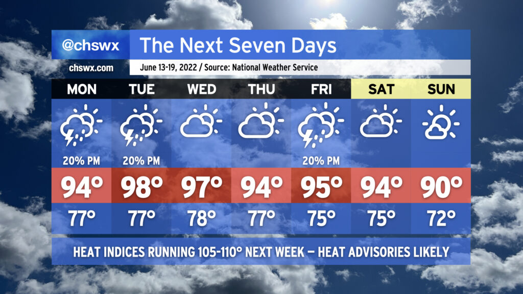
The hottest weather thus far in 2022 will arrive this week as a strong ridge of high pressure builds over the Southeast. The heat wave will peak Tuesday and Wednesday, with highs in the upper 90s expected and heat indices likely exceeding 110° both days. We stay hot heading into the weekend before a frontal system looks to push through Saturday night, leaving us with slightly cooler temperatures — if you could call 90° “cooler” — for Sunday.
Compounding things, low temperatures will struggle down to the mid-70s on the coolest mornings. There may be some mornings near the coast where temperatures don’t drop below 80°. The heat during the day with the lack of cooling at night will make for an oppressive few days. Check on your neighbors, especially those with vulnerability to the heat, during this tough stretch. Make sure you’re getting plenty of water and taking frequent shady breaks if you’ve got to be outside during the peak of the afternoon.
Thunderstorms will be few and far between for much of the week, with the better rain chances likely overnight Saturday into early Sunday morning with the frontal passage. Even then, right now the rain probabilities are in the 20-30% range.
Finally, astronomical factors and favorable winds will combine for minor to moderate tidal flooding with each evening’s high tide. Be ready for road closures in a few spots in downtown Charleston at times this week, and keep an ear out for Coastal Flood Advisories from the National Weather Service.
Overall, we’ve got a pretty standard June week ahead in the Lowcountry, with temperatures turning warmer as the week progresses. We’ll go from the mid-80s on Monday to the mid-90s by Thursday and Friday ahead of a cold front that will approach the area for the weekend.
We’ll have the customary summertime slight shower and thunderstorm chance most afternoons (though Tuesday and Wednesday look more likely to stay dry than not). As we head toward the weekend, though, we’ll be watching the aforementioned front and a sharpening trough aloft for an uptick in shower and thunderstorm chances perhaps as early as Friday, but more likely as we get into the weekend. As is customary in June, showers and thunderstorms will be on-and-off, primarily concentrated in the afternoon, and not a total loss of a day as a result. (And yes, it’s too soon to say just how much of an impact we’ll see on the Spoleto finale at Firefly.) Just make sure outdoor activities have backup indoor plans in case showers and thunderstorms approach. While severe weather doesn’t look terribly likely, lightning makes every thunderstorm dangerous. When thunder roars, go indoors!
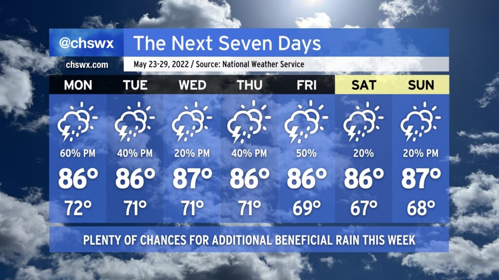
It rained today — really, really well, in fact — and that felt nothing short of miraculous. Quite a few gauges in the metro area recorded over 1” of rain from this morning’s thunderstorms. We’ll have additional shots at beneficial rainfall this week, especially at the beginning and the end, while temperatures generally remain around normal.
Showers and thunderstorms are expected to redevelop during the day Monday as slugs of tropical moisture from a disturbance in the Gulf — the first to gain the Hurricane Center’s attention this year, though development is unlikely — traverse the area and interact with a stalling cold front to our north. This should bring some more substantial rains to at least some of us by Monday afternoon. Temperatures will hold in the mid-80s given cloud cover and expected thunderstorm activity.
The stalled front hangs around Tuesday, though the Gulf disturbance will be departing the weather picture. There will still be plenty of moisture around, though, and that combined with the lingering front should help kick off additional showers and thunderstorms in the afternoon. Expect more of the same going into Wednesday, too, though showers and thunderstorms should be a little more isolated. Rain chances head back up for Thursday and Friday as a cold front pushes toward the area from the west. There’s still going to be plenty of moisture around, and some heavy rainfall will be possible from any storms that develop.
The cold front clears the area and stalls out offshore as we kick off the Memorial Day weekend. Rain chances could still hang around given the proximity of the front, but they’d be relatively slight. It should feel a touch less humid, too, which would be welcome news as Spoleto opens. Keep an eye on forecast updates as this will become more clear as the week goes on.
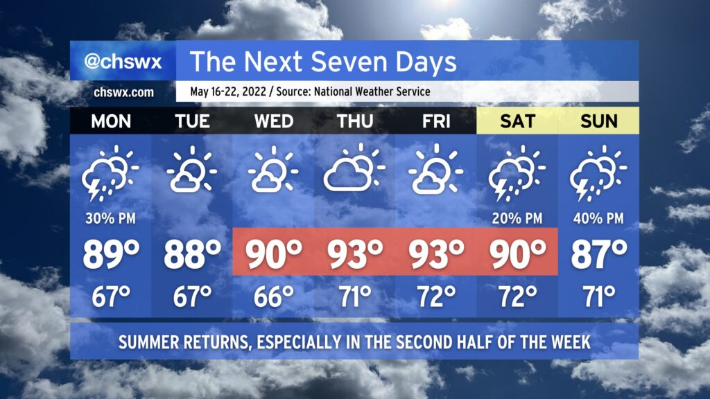
Summer’s back this week as above-normal temperatures once again take root across the area thanks to high pressure and dry air precluding much in the way of thunderstorm formation for a majority of the week.
Monday afternoon offers the best shot at a shower or thunderstorm — albeit at around a 30% probability — as a cold front approaches the area and stalls out. A storm or two could be on the strong side with damaging wind gusts and large hail possible., but the vast majority of us won’t see severe weather, and a good bit of us may not even see much in the way of rain — unwelcome news for a still-parched Lowcountry.
The aforementioned front stalls out Tuesday and lingers in the area through Wednesday. Drier air, though, is going to keep rain chances squelched for the most part. Once the front lifts back north as a warm front and high pressure builds back from the west Wednesday into Thursday, temperatures will start to respond by heading into the low to even mid-90s in some spots, especially Thursday and Friday. Meanwhile, rain chances are held to a whimper.
High pressure starts to loosen its grip over the weekend, and afternoon thunderstorm chances start to tick up as a result (though isolated to scattered coverage is expected at best). Highs will continue to run above normal in the low 90s on Saturday before moderating slightly back to the upper 80s on Sunday.
For now, though, keep on watering and feel free to get your car washed, because Mother Nature’s going to be of little to no help in that department for at least the next week.
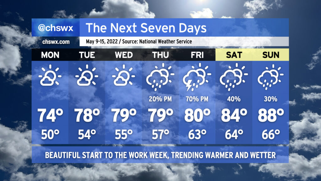
After a highly unseasonably cool Mother’s Day, temperatures will remain generally pleasant over the next few days as high pressure runs the show. We’ll see a gradual warming trend into mid-week, with highs topping out near 80° by Wednesday. Lows, though, will continue to run well below normal in the low to mid-50s away from the coastline into Thursday. Skies should be more clear than we saw for much of today, too — keep the sunscreen applied if you’re out and about!
On Thursday, shower chances will begin to increase in the afternoon as moisture from an offshore low pressure system begins to kick up some as said low moves more westward. The best chance of rain will arrive Friday as the low moves across the area, with the potential for a few heavy downpours in there as well. (Fingers crossed, given the current drought situation!) Shower chances linger into the weekend as above-normal temperatures return. Sunday could once again approach 90° in some locations — ’tis the season.
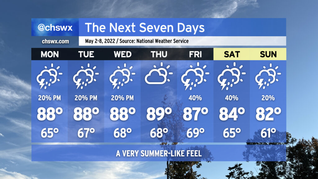
The first week of May will serve as a preview of what’s to come as we edge closer and closer to summertime. The mornings will become increasingly muggy with lows bottoming out in the mid-60s on Monday and getting warmer as the week goes on. Highs for much of the week will run in the upper 80s; dewpoints in the upper 60s will make the afternoons feel more like the low 90s. We’ll even see that standard afternoon slight chance of thunderstorms that we know and love in the warm season Monday-Wednesday.
As we head into Friday and the weekend, a storm system will push a stalled cold front into and eventually through the area, elevating our chance of scattered showers and thunderstorms for Friday and Saturday. By Sunday, expect the front to be through, cooling us off a little with highs in the low 80s expected, making for what should be a nice Mother’s Day with just a slight chance of a shower or storm in the afternoon.