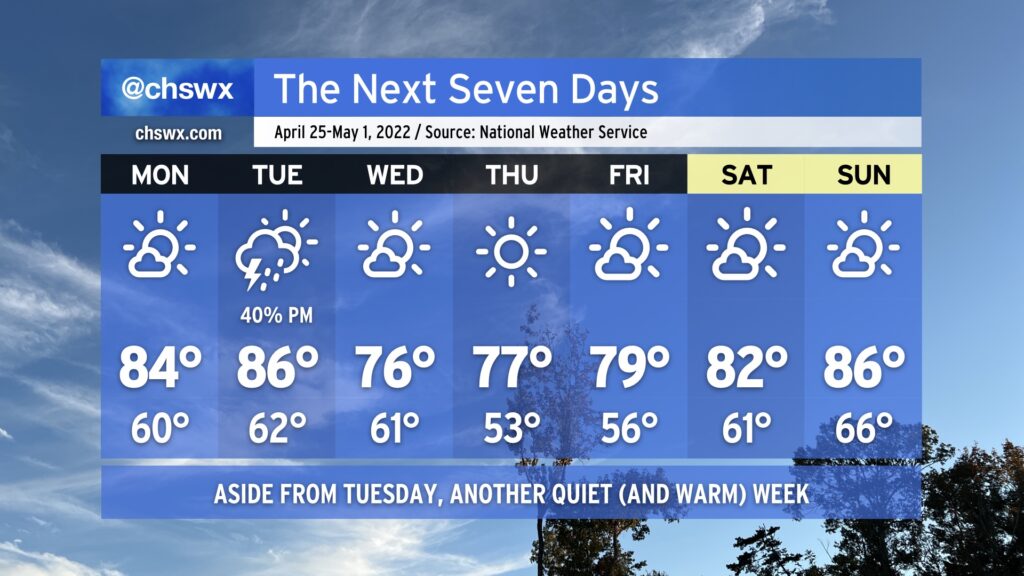
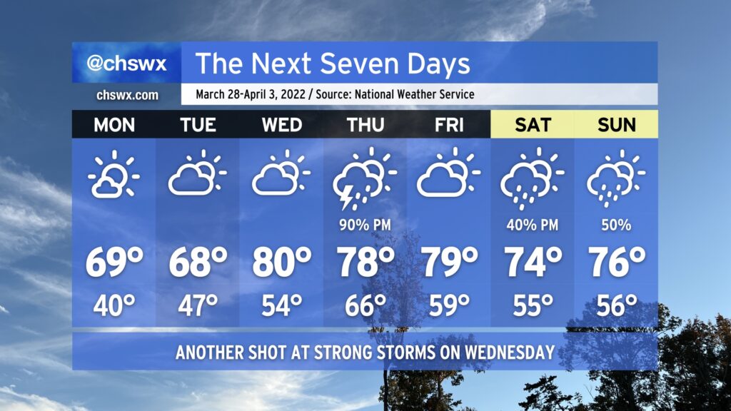
Another mostly nice-looking week lies ahead to close out April, a stark contrast to how this month got started. We start the work week as warm as we’ve been thus far in 2022, with highs topping out in the mid-80s on Monday and Tuesday ahead of a cold front. The only rain chance will be a shot at some showers and thunderstorms Tuesday afternoon and evening as the front passes by. These don’t look like they’ll be terribly organized, keeping the severe threat to a minimum.
Once the front is through overnight Tuesday into early Wednesday, we’ll see temperatures cap out around the mid-70s Wednesday and Thursday afternoons with very few clouds to speak of. A warming trend commences in earnest Friday as high pressure begins to slip back offshore, and we may very well start May off on a warm note on Sunday with highs in the mid-80s.
Overall, we largely continue to be spoiled by great weather (though we could still use some more rain given the ongoing drought). Enjoy!
The work week will certainly get off to a meteorologically inauspicious start: Showers and thunderstorms will be ongoing from overnight Sunday heading into Monday morning. Heavy downpours will certainly be possible, so you’ll want to make sure you’re allowing extra time to get where you’re going in the morning. (You know how it gets around here when it rains.)
The bulk of the rain heads offshore by midday, but the short-range and convection-allowing models allow the atmosphere to recover some before the cold front gets through. This is kind of tricky as a high pressure wedge will be trying to build southward at the same time, and models are notorious for under-doing this. I wouldn’t rule out an additional shower or storm forming in the afternoon hours, but that’ll be highly conditional on just how much the atmosphere recovers before the front gets offshore, which is expected generally around mid-afternoon.
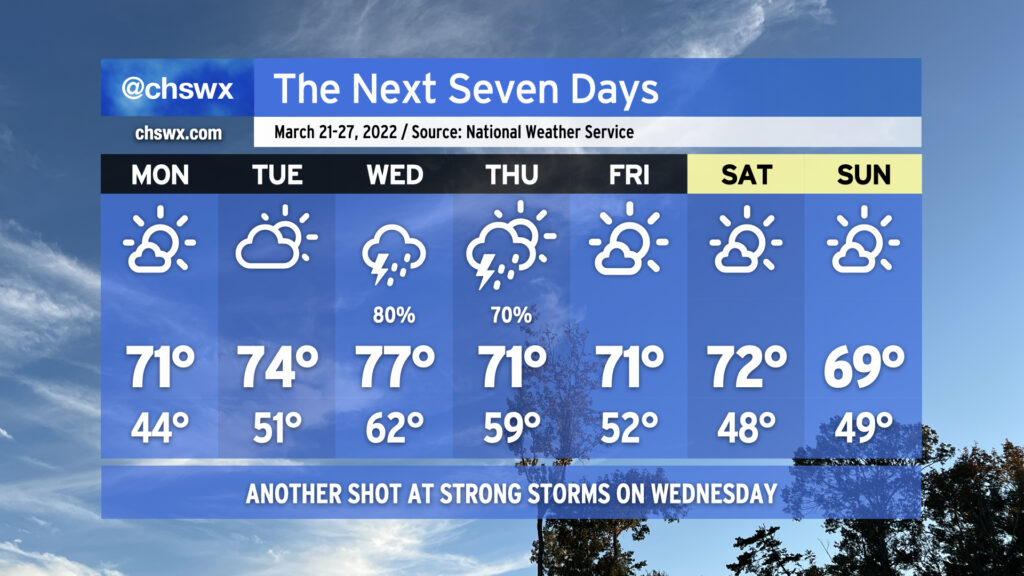
From there, though, the week turns nice and tranquil. Tuesday and Wednesday will run much cooler than normal for mid-April as highs only top out around 70° each day despite full sunshine. Ridging will develop aloft thereafter, allowing temperatures to warm into the mid-70s on Thursday and back into the 80s for Friday and the weekend. All the while, we look to remain rain-free given the firm control high pressure will have over our weather at the surface and aloft.
The only potential fly in the ointment will be the risk for minor coastal flooding late Monday night, when high tide around 10-11 PM looks to peak in the 7.2-7.4’ range. Thereafter, though, the effects of the new moon and perigee diminish, bringing a quick and merciful end to this round of coastal flooding.
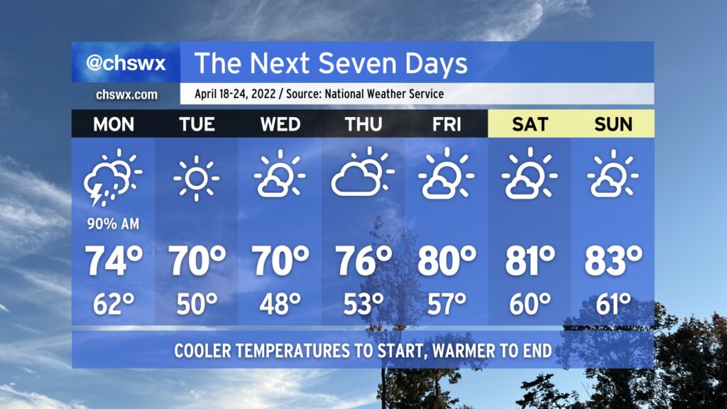
After a rather chilly weekend by mid-April standards in the Lowcountry — we only got to 58° on Saturday, one degree off the record low maximum — above-normal temperatures return to the picture for the week ahead as ridging develops aloft. We stay calm to start the work week, but unsettled weather re-enters the picture beginning Thursday and possibly lasts into the weekend.
Temperatures will take quite a swing on Monday — we’ll start in the upper 40s across the area on our way to 80° in the afternoon under mostly sunny skies. This will get Tuesday off to a warmer start — think mid-to-upper 50s — as we once again head back to the low 80s in the afternoon. Expect similar weather, save for a few more clouds, on Wednesday.
As we get into the second half of the week into the weekend, the upper-air flow becomes a little more zonal (blowing more straight west-to-east) as a trough digs in to our north. This should send a cold front into the area — but perhaps not through it — as we close out the work week, bringing along some shower and thunderstorm chances. Thankfully, the setup shows no signs of repeating the severe weather we experienced last week. Beyond there, model solutions are diverging a bit as far as the weekend goes, but some unsettled weather could be in the cards as we head toward Easter. Regardless, temperatures look to stay above normal through the weekend. We may yet head below normal again the following week, though, but that’s for another day.
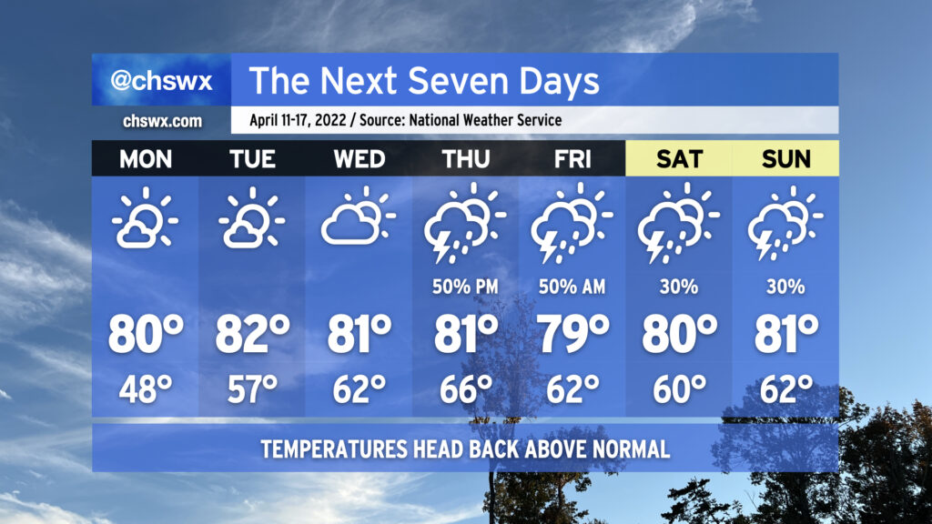
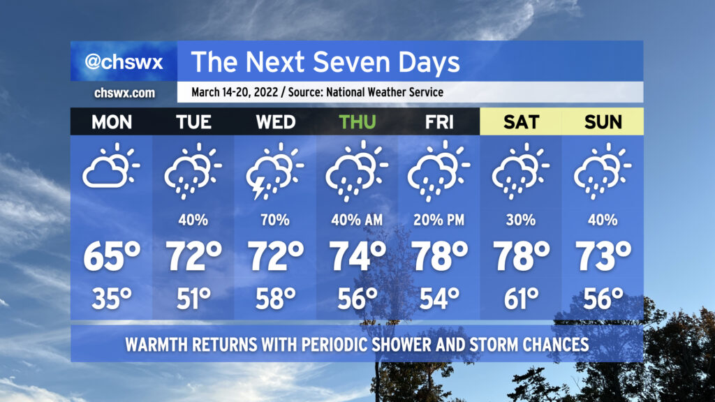
The week ahead will feature a series of storm systems right in the middle of the work week followed by a return to below-normal temperatures for Friday and the weekend. A few severe storms could be in the mix, particularly on Tuesday. (And yes, it’ll be windy again.)
Monday starts out the work week with another partly cloudy and generally pleasant day. Temperatures will top out in the mid-70s, running a couple clicks cooler with winds shifting onshore. Clouds will be on the increase ahead of our storm system, but we should still see plenty of sun for the duration of the day.
A warm front will lift north of the area early Tuesday, kicking off an unsettled period right smack dab in the middle of the work week. So far, it looks like the best — albeit still small — risk of a strong to severe thunderstorm in the Lowcountry will arrive on Tuesday given decent instability and a strong low-level jet, which — stop me if you’ve heard this before — will likely help to contribute to gusts pushing 40 MPH during the day Tuesday outside of thunderstorms. Given the elevated wind fields, thunderstorms could give a little extra “oomph” to these winds, creating a damaging wind threat.
On Wednesday, there’s no real forcing mechanisms around to kick off widespread shower and thunderstorm activity, but temperatures in the low 80s should allow for popup showers and thunderstorms to develop. Then on Thursday, one more cold front swings through in conjunction with a large, lumbering mid-level low centered over the Great Lakes, bringing one more round of showers and storms for this forecast period. Behind this front, temperatures will drop below early April normals for Friday and the weekend, with temperatures perhaps not getting out of the 60s. Fortunately, so far it doesn’t look like there will be any frost or freeze concerns, but we’ll keep an eye on it.
Work week rain can sometimes be a bummer, but we sure do need it as moderate drought continues to envelop the Lowcountry. If we can get it without severe weather, all the better.
We’ve got a day or two more of chilly weather (for late March, anyway) before temperatures rise quickly on Wednesday as a storm system approaches the area. From there, a stalled front provides additional opportunities for rainfall over the weekend.
Our stretch of cool and fair weather continues into Monday at a minimum. There will be actual clouds in the sky on Monday, generally of the high variety as a little moisture squeezes out around the base of the trough that’s brought us this very chilly weekend. Temperatures will remain on the cool side, bottoming out in the 40s in the metro area and perhaps the mid-30s in more rural areas, prompting a Frost Advisory for Inland Berkeley County.
A warm front will approach the area on Tuesday, allowing for more cloud cover to develop. It’s not clear just how far north said front might get yet; the current forecast is for temperatures to once again top out in the upper 60s, but it’s possible that the afternoon could run a touch warmer if the front is able to make a little more headway.
Wednesday will offer one more rain-free day before the storm system gets into the area. By then, the warm front will have lifted north of us, with highs in the upper 70s to low 80s running in stark contrast to what we’ve experienced over the past few days.
The next appreciable rain chance arrives Thursday afternoon and evening with a cold front; rainfall looks likely with some rumbles of thunder, but the higher severe weather risk is displaced to the north with the better dynamics. We’ll get a break in the rain on Friday, but with the front stalling out to our southwest, shower and storm chances remain in the picture through the weekend. Temperatures, meanwhile, will remain a little above normal.
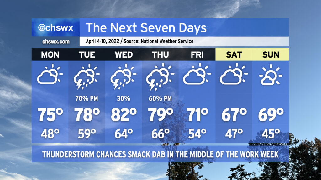
The week ahead will be bookended by really nice weather, though we’re going to need to get through another risk of showers and thunderstorms — yes, with a few possibly being severe — on Wednesday before we get through to the weekend.
For Monday, though, expect a slightly less windy carbon copy of Sunday. After starting in the mid-40s, highs will topping out in the low 70s under mostly sunny skies as cool and dry high pressure hangs on for one more day. We’ll see temperatures begin to head back up on Tuesday along with cloud cover as high pressure slips offshore in advance of our next storm system on Wednesday.
Wednesday will once again test our stretch of good luck with severe weather threats so far this spring. We’ll see a warm front lift across the area in the morning, putting us (at least briefly) in the warm sector of a strong storm system which is forecast to bring significant weather impacts to the Gulf Coast over the next two days. While in that warm sector, temperatures look to warm to the upper 70s despite decent cloud cover. Early calls from the models show decent instability and ample shear supportive of a slight severe weather threat. Given the close proximity of the front, I’d expect a more linear storm mode with damaging straight-line winds the primary concern, but there seems to be enough low-level shear to support a low-end tornado threat as well. Even outside of thunderstorms, winds look to be rather gusty courtesy of a strong low-level jet moving across the area. So, you’ll want to keep an ear out for forecast updates for the next couple days as the details are worked out.
Exact timing on the front’s passage will still need to be worked out, but overall, expect rain chances to trend downward as Thursday goes on. The front will leave behind a rather pleasant airmass with plenty of sun, low humidity, and high temperatures running near normal (low 70s) for Friday and the weekend. And so it goes with spring — some really nice weather mixed with the occasional nastygram.
The week ahead features a return to warmer weather with shower and thunderstorm chances mixed in as the pattern remains somewhat unsettled across the Southeast.
Frost and freeze conditions will give way to warmer — but still a touch below normal — high temperatures across the area on Monday as we warm into the mid-60s. Cloud cover will be on the increase as surface high pressure slips offshore and moisture return improves on the back side of the high. Rain chances begin to tick up later in the day on Tuesday as an upper-level low cuts off over the Arklatex and begins to move eastward, spreading some energy into the area and spawning a surface low pressure system. The cutoff low will move by the Carolinas on Wednesday, and with surface low pressure in place, this will help generate showers and thunderstorms across the area. A couple strong storms might not be out of the question on Wednesday, so that’ll be a trend to watch.
The upper low opens back up into a trough as it moves back into the Atlantic later Wednesday into early Thursday, leaving behind a little bit of ridging and thus quiet weather for the better part of Thursday heading into Friday. Another upper-level low will be moving across the mid-South on Friday, and the associated surface front will approach the area heading into the weekend, bringing some showers and maybe a thunderstorm into our forecast.
Thankfully, there’s no further return to winter in this forecast; no frost and freeze concerns are expected after Monday morning, and temperatures will generally run above normal throughout the week, ranging from the mid-60s on Monday to the low-to-mid-70s Tuesday through Thursday before warming up into the upper 70s to near 80° for Friday and Saturday.
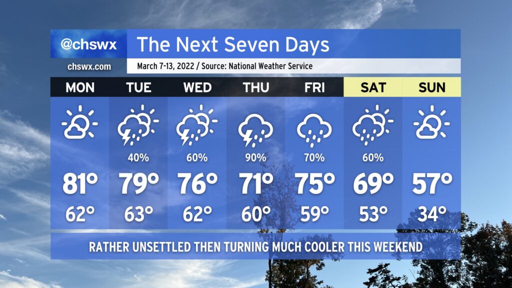
A solid pollen rinse is in the offing this week as a cold front is forecast to stall over the area, keeping showers and thunderstorms in the area for much of the upcoming work week.
First, though, we have one more day of great weather teed up for Monday. It’ll be a good day to catch a meal outside at some point during the day with highs once again topping out in the low 80s under partly cloudy to mostly sunny skies.
A cold front will then approach the area on Tuesday. Shower and thunderstorm chances increase through the day on Tuesday, though it won’t rain all day. The front will stall out across the area on Wednesday, and waves of low pressure will ripple along it, keeping persistent cloud cover, shower, and even some thunderstorm chances in play. Our best rain chances right now look to be in the Thursday-Friday timeframe. Saturday should still feature some showers, but rain chances will be headed down as one final cold front pushes through the area, which will bring quite a cooldown to the area — think upper 50s for Sunday’s highs, which is quite a bit below normal for this point in the year. If you’ve not planted, think about delaying a bit longer — we could be talking frost and freeze issues heading into mid-March, because that’s what March does.
We do need the rain, that’s for sure — we are running way behind so far this year and are getting into quite a drought. The pollen rinse will certainly help, too!
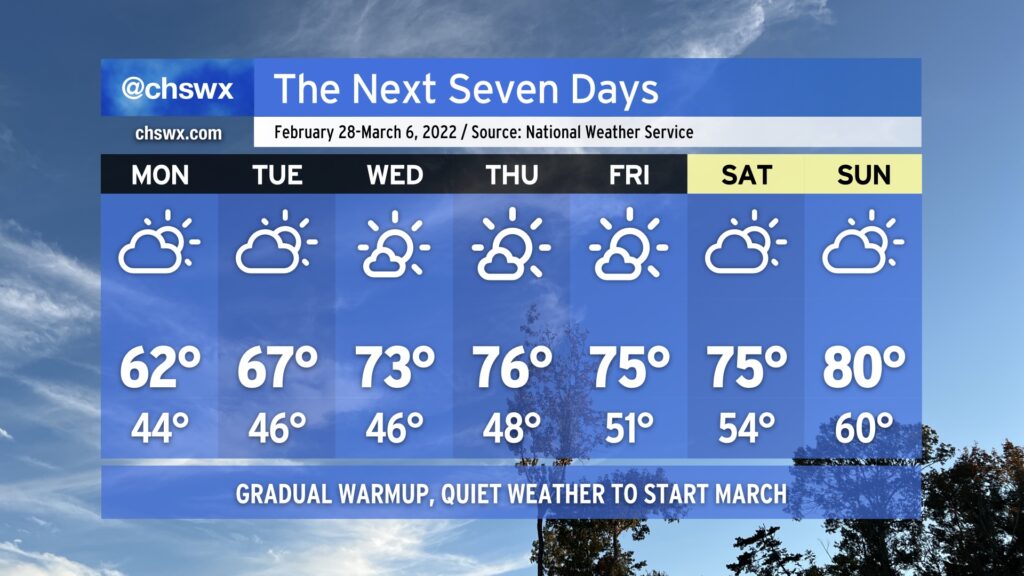
February gives way to March this week with very little fanfare in the weather department. We start the week with temperatures running a touch below normal, but a gradual warmup is in the cards as we get through the work week before we approach 80° by the weekend. High pressure will keep things rain-free for the next few days, though it may be a little more cloudy than we might like Monday into Tuesday.
The only main weather concern this week will be the risk for minor coastal flooding with the Monday and Tuesday morning high tides thanks to persistent northeast flow and the upcoming new moon. The 6:03am high tide Monday morning could clip 7’. Tuesday morning’s will run a little higher around 7.2-7.4’, which could close a few vulnerable roads near the edges of the Charleston peninsula. Beyond then, winds begin to go around to the north and then the west, which will cut down the coastal flooding risk for the rest of the week.
After a really nice, seasonable weekend, temperatures will climb back into the 70s again on Monday, with 80s returning to challenge record highs by mid-week. A cold front looks to snap us back to more seasonable temperatures for the weekend.
Precipitation-wise, there will be a slight chance for some showers on Monday as a coastal trough develops and brings Atlantic moisture inland, but we otherwise look to stay dry through Friday, when the front brings a small chance of showers to the area.
With such warm temperatures and cooler shelf waters, sea fog is certainly a possibility over the next few days. This may impact visibility and temperatures at times, especially near the coast.