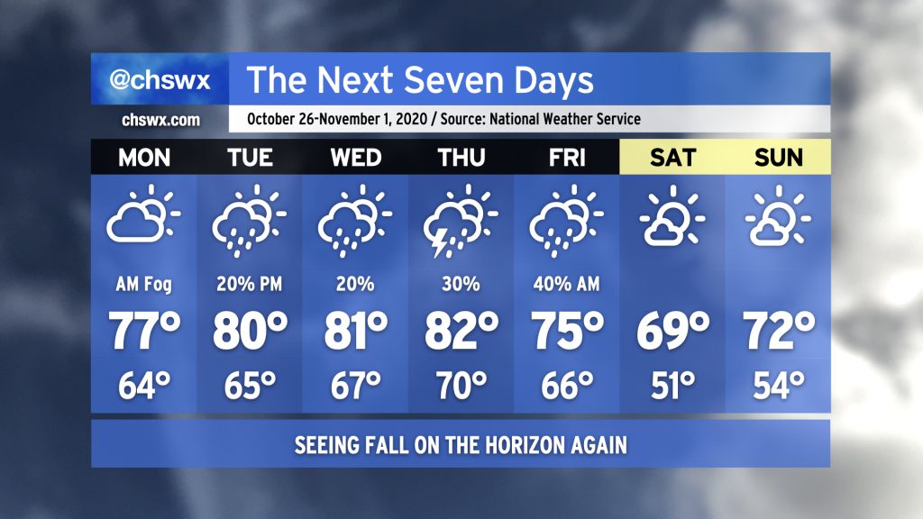
We’ll close out this rather warm month of October (eighth warmest on record as of this evening) with one last stretch of warm, muggy days before a storm system rolls through the area Thursday into Friday.
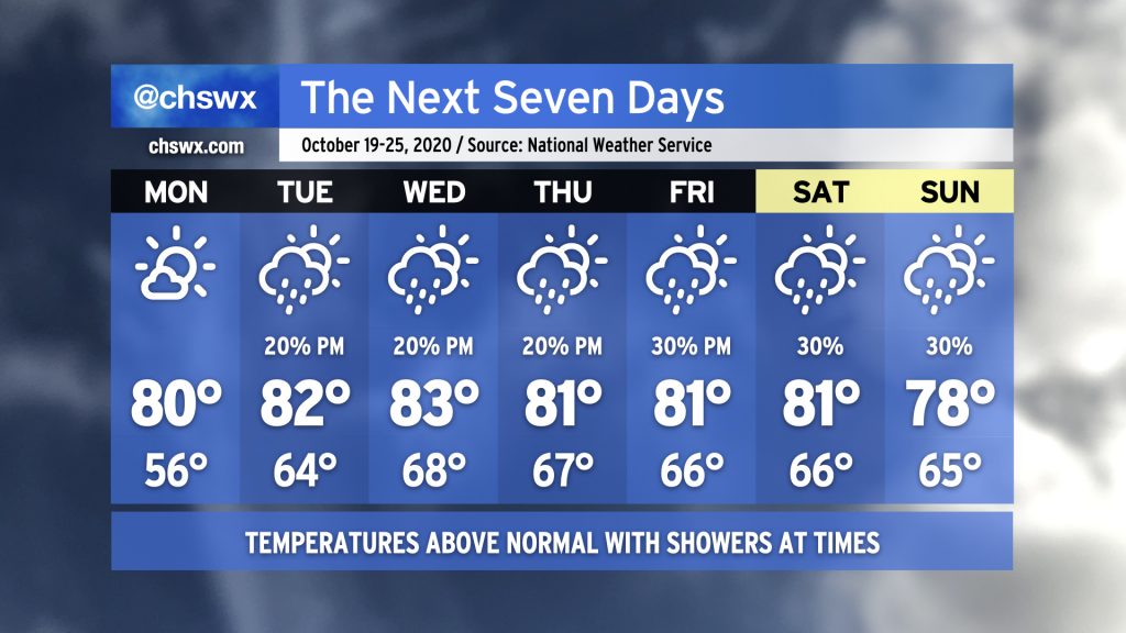
Temperatures will head back above normal this week with shower chances coming back into the picture starting Tuesday. Showers will be isolated to scattered at best for most of the week as a coastal trough persists. Onshore flow will keep dewpoints up, making for a warm and humid mid-to-late October week. Expect highs in the 80s just about every day with lows in the mid-60s. (Closer to the coast, take a couple degrees off the high and add it to the low.)
The remnants of Delta are on their way out, giving way to a series of fronts over the next few days that will gradually ease us back into fall weather. First, though, we will still contend with elevated heat and humidity Monday into Tuesday with highs in the mid-80s and dewpoints in the low 70s. Then, a front will wedge in from the north, cooling us off a little for Wednesday and Thursday with highs only topping out in the low 80s. A better shot of cooler and drier air arrives late Friday into early Saturday — perhaps with some showers — as another area of high pressure builds in from the west. This one will bring us back to fall, with upper 60s to around 70° for Saturday and low 70s for Sunday.
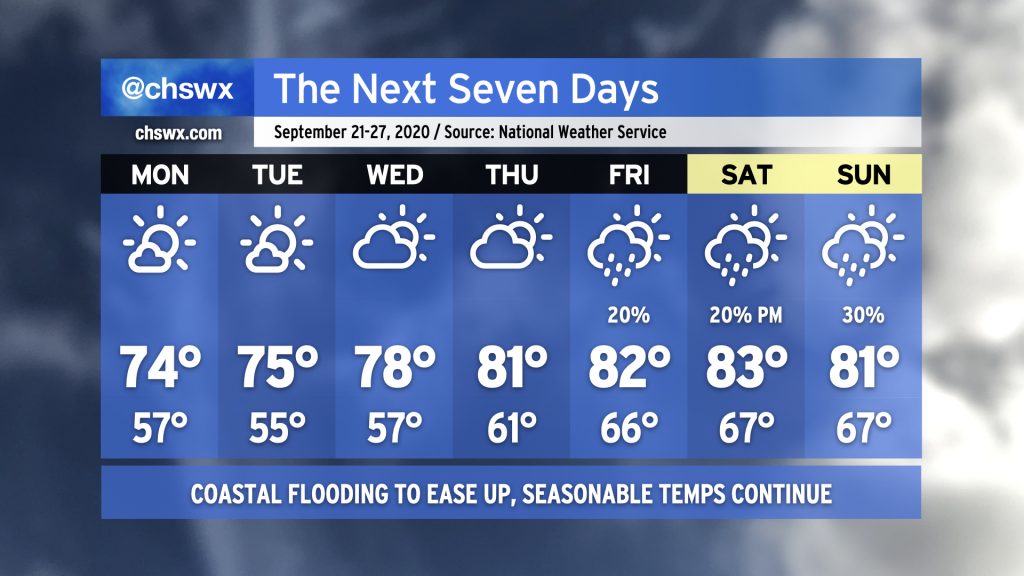
Temperatures this week will run a little warmer than last week with a bit more moisture in the area. We’ll start off the work week with a pleasant mix of sun and clouds and a high in the mid-70s. A little more moisture moves in with a trough of low pressure on Tuesday, bringing some shower chances to the area. Temperatures warm into the low 80s for Wednesday and Thursday before high pressure wedges in, with moisture riding over the top of the wedge bringing some shower chances into the cards. Overall, not too shabby, if not quite as crisp as it felt last week.
We’ll start this new work week rainy and warm ahead of a cold front. NWS is forecasting 1-2″ of rain for most of us through early Wednesday before the front swings through. And once that front swings through, what a difference — humidity will get knocked back down a peg and we’ll get into a really nice fall-like pattern to start October with highs in the 70s and lows generally in the 50s away from the coast.
Keep an eye on Tuesday’s forecast. As the cold front swings through with low pressure riding just to the north, there will be a chance for a couple strong storms. Right now, widespread severe weather is not expected. We’ll keep an eye on it.
Otherwise, make sure your hoodies and other light jackets are present and accounted for as we turn nice and crisp heading into next weekend!
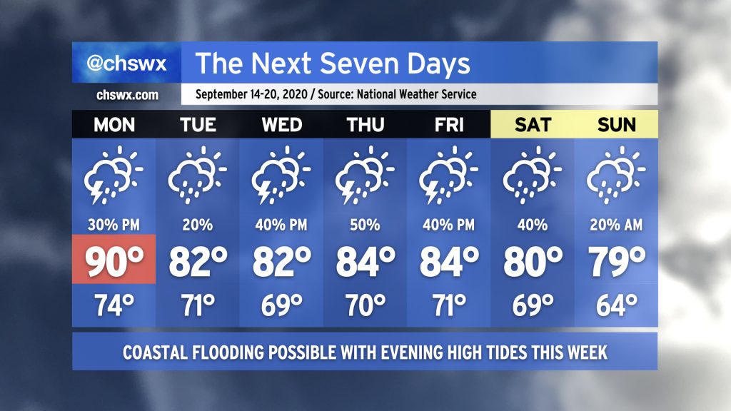
We’ll start the week off continuing our taste of fall, with highs running in the mid-70s and lows in the mid-50s — the coolest since mid-May — expected through Wednesday. We’ll also continue to take a break from the rain for a few days as high pressure continues to build overhead. Coastal flooding will remain a concern with Monday and Tuesday’s high tides, with major flooding possible with the high tide cycles on Monday before gradually diminishing on Tuesday. By Wednesday, the coastal flooding risk will have ended.
As we get later into the week, we’ll see some moisture stream into the area courtesy of the remnants of Tropical Storm Beta. This could instigate a few showers at times as we head into the weekend. We’ll also see an uptick in temperatures and humidity as well, but we’ll stay right around normal for late September, so don’t expect anything too heinous.
So the first thing you will undoubtedly notice in the seven-day is that it is largely bereft of 90s (save for Monday). You may also notice a high of 79° for Sunday. Yes, that’s out there a ways and could still be tweaked upward, but it is just refreshing to see 70s for highs somewhere in the forecast. We’ll need to deal with some rain and coastal flooding to get here, though.
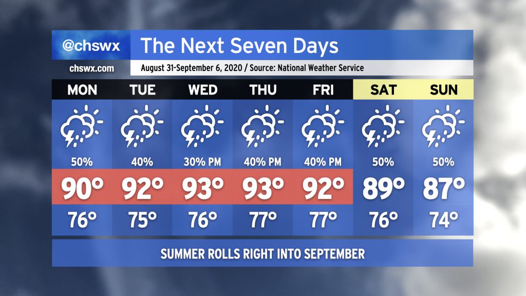
While meteorological fall begins on September 1, summer will blaze on in the Lowcountry over the next several days as we remain within a warm and humid airmass. Showers and thunderstorms will be possible each afternoon along the seabreeze and other outflow boundaries generated by thunderstorm activity. As we head toward the weekend, a nearby frontal boundary could aid in additional showers and thunderstorms. We could see temperatures come down a little bit for Sunday as winds turn more onshore, but showers and storms remain in the forecast.
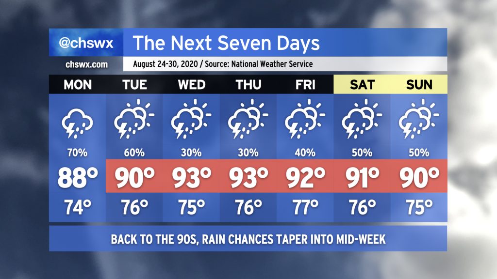
After what was an uncharacteristically wet and cloudy weekend across the Lowcountry, we will gradually move back into a more typical late-summer regime of afternoon thunderstorms and temperatures reaching the low 90s for the upcoming work week. But first, we’ll need to deal with a higher-than-normal risk for additional showers and thunderstorms on Monday, with potentially heavy rain having impacts starting early in the morning.
We continue to watch Hurricane Marco and Tropical Storm Laura as they continue on an unfortunate course to delivering a 1-2 tropical punch to parts of the Gulf Coast next week. Aside from some enhanced moisture funneling into the area from the storms around the western side of the Atlantic ridge through Monday, it does not appear that Marco or Laura will have any impacts in our area. We are now in the peak of the season, though, and we’ll want to keep a close eye on any waves that meander into the Atlantic from Africa for development over the next few weeks. Stay tuned…
After a brief respite from suffocating humidity today — the overnight temperature dropped to 69°, according to NWS, the coolest since June 20’s low of 67° — we will see rain chances return to the forecast as the upper trough which has kept things quite unsettled remains in place for the next few days. Brief bouts of heavy rain will be possible once again, but it won’t rain all the time or even every day at one particular spot. As we get into the weekend, Atlantic high pressure looks to build back into the area, which will help tamp down the overall coverage of storms (and begin sending temperatures back upwards a bit).