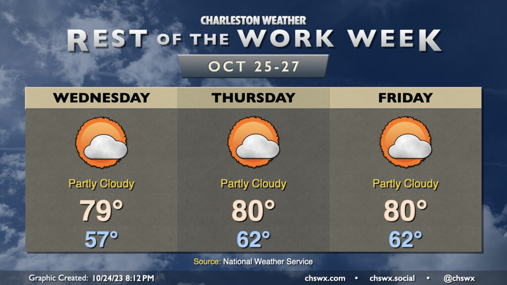
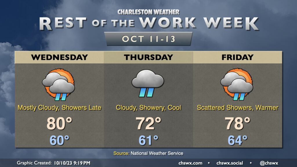
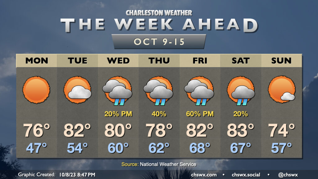
The rest of the work week will be seasonably warm as high pressure remains in firm control of our weather. We’ll start Wednesday noticeably warmer than Tuesday with lows in the upper 50s as opposed to the upper 40s. From there, temperatures will warm to near 80° under partly cloudy to mostly sunny skies. We start Thursday even warmer, with low 60s forecast — several degrees above normal for this point in the year. Temperatures top out around 80° with a mix of sun and clouds. As for Friday, copy and paste — pretty much the same story as Thursday. We keep warmth heading into the weekend and to start next week, though we should see a cooldown in time for Halloween.
High tides on Wednesday will get close to coastal flood criteria and could yet require a Coastal Flood Advisory or two if the departures tick up just a little more. We’ll flirt with minor coastal flood criteria at times of high tide into the weekend, so keep an ear out for possible Coastal Flood Advisories from the National Weather Service.
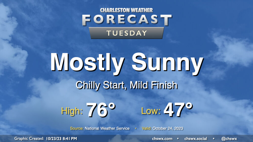
We get off to a fairly chilly start on Tuesday as lows bottom out in the upper 40s thanks to clear skies and light winds. This will be the low-water mark (so to speak) for temperatures, though, as we head into the rest of the week. Highs on Tuesday top out in the mid-70s once again, perhaps a degree or two warmer than we saw on Monday. All in all, another nice October day.
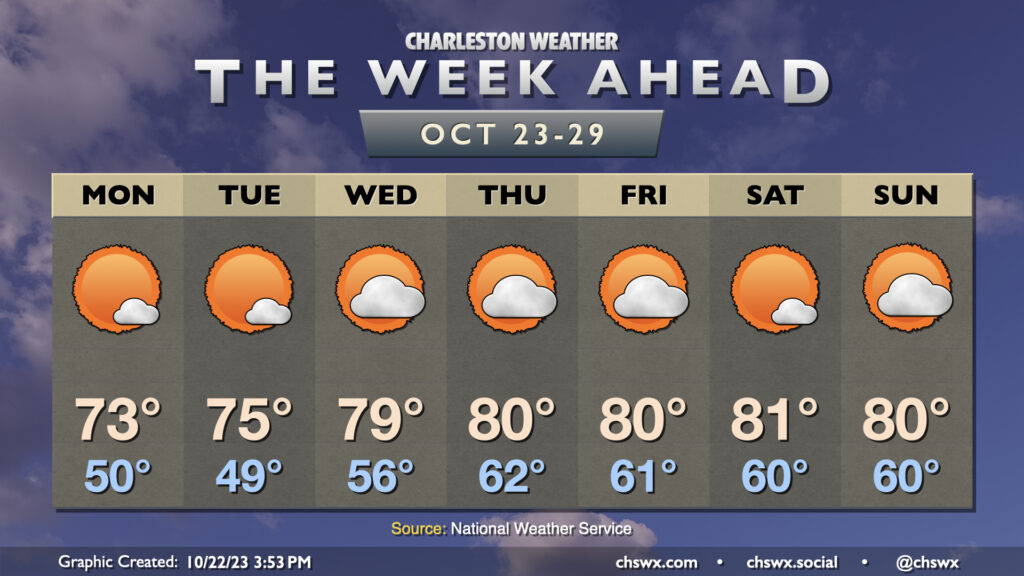
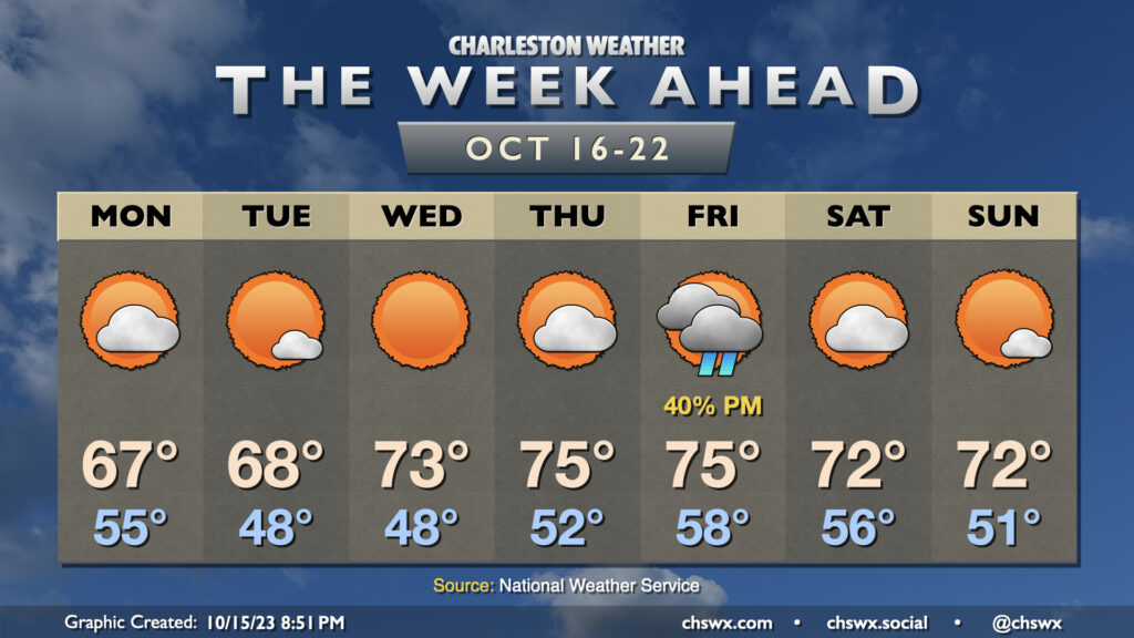
The story of this week’s weather will be high pressure keeping a firm grasp on the area for the rest of the week (and maybe even the rest of October). This will lead to generally quiet weather, with a warming trend bringing us into the low 80s starting around midweek. Monday will be the coolest of the set in the wake of a dry cold frontal passage; we start the day around 50° and warm into the low 70s in the afternoon with just a few clouds. Tuesday starts a touch cooler, but the warming trend will begin with temperatures reaching a little warmer in the afternoon. A decent stretch of above-normal warmth takes hold from there, with variable cloud cover but little else to write home about as moisture is generally scant. All in all, it’s not a bad week to get the car washed (note to self) and enjoy some outdoor lunches.
The only concern may end up being coastal flooding at times of high tide possibly starting as early as Tuesday. Winds will be out of the northeast as high pressure settles in to our northwest, and this combined with the upcoming full moon will once again start to send water levels above coastal flood criteria as we head into the latter half of the week. Keep an ear out for Coastal Flood Advisories from the National Weather Service.
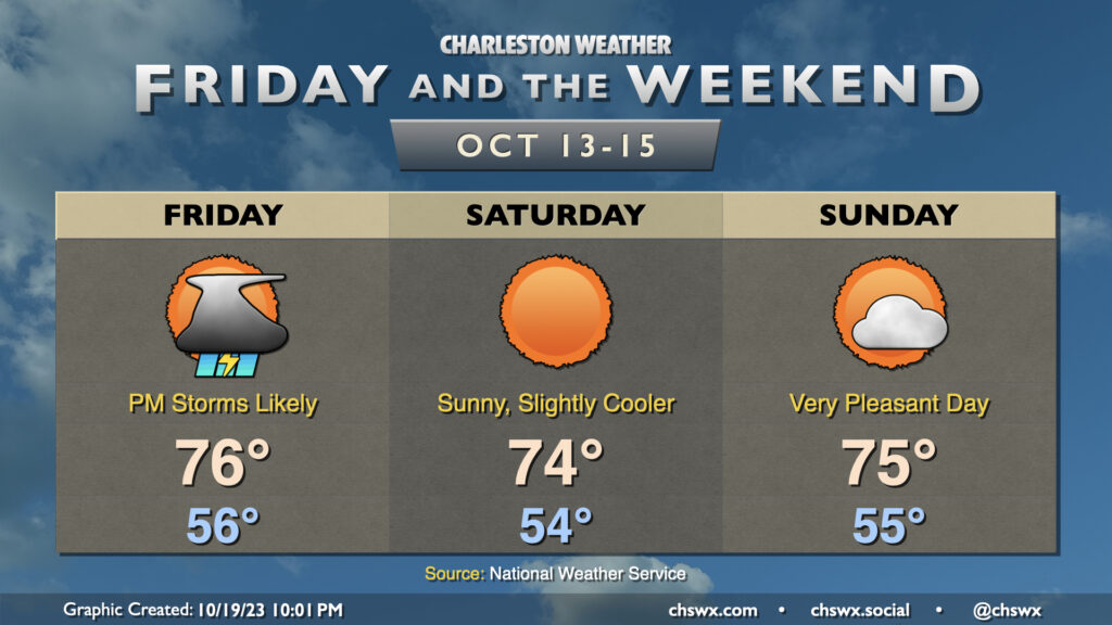
Showers and a few thunderstorms re-enter the weather picture for Friday as a cold front moves by, but it’ll be worth it as we have a gorgeous weekend ahead.
We start Friday in the mid-50s with dewpoints steadily rising throughout the day. Showers and thunderstorms will approach the area from the west as the day goes on, with storms possible perhaps as early as 1-2 PM, but most likely in the late afternoon to early evening hours. A storm or two could even be on the strong side, with damaging wind gusts the main concern. Rainfall between a quarter and half-inch is generally expected, with some spots under- and over-performing as is common with these kinds of convective setups. Due to the ongoing dry conditions, though, flooding is not expected to be an issue.
From there, the weekend looks great. Skies clear nicely for Saturday, and northwesterly flow will yield a rather beautiful day with lows in the mid-50s yielding to highs in the mid-70s in the afternoon with nary a cloud to be found. Sunday will be another really nice day with temperatures generally similar to Saturday’s, though we’ll see a bit more in the way of scattered clouds ahead of a dry frontal passage late. All in all, it looks to be a fantastic weekend to get out and do stuff.
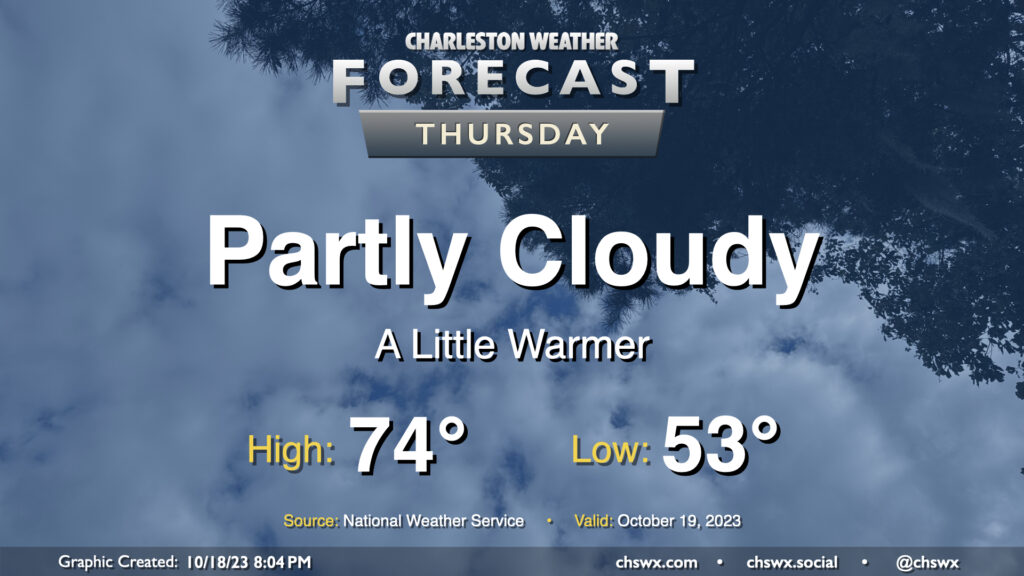
Expect clouds to be on the increase on Thursday as a coastal trough develops nearby, spreading some cloud cover onshore. Somewhat more southerly trajectories will allow temperatures to run a little warmer (but still below normal). Expect to start the day in the low-to-mid-50s before temperatures head to the mid-70s in the afternoon. Despite increasing clouds, expect one more rain-free day ahead of a cold front arriving Friday.
Overall, we’ve got a pretty nice week ahead with temperatures running generally below normal and only one passing rain chance on Friday.
A trough moving by overnight Sunday into Monday could bring a few showers early Monday morning, but those will be done by daybreak, and we should see a partly cloudy day with highs topping out only in the mid-to-upper 60s, some 10° below normal for this point in the year. (Might be a little taste of sweater weather?) We start Tuesday in the upper 40s with highs once again peaking shy of 70° with more sunshine expected. We have a similarly cool start Wednesday but with unfettered sunshine, expect highs to top out in the low 70s. Thursday runs a little warmer with lows starting in the low 50s and highs in the mid-70s with a little bit more in the way of cloud cover (but still plenty of sun, too).
Our only real rain chance this week arrives ahead of a cold front on Friday. Generally, expect a scattering of showers in the afternoon and evening ahead of the front, but nothing too outrageous. Highs will run in the mid-70s. Behind the front, a modest cooldown will ensue, but it should be a really nice weekend with lows in the 50s and highs in the low 70s each afternoon.
Increasing moisture will proliferate across the area during the day Wednesday as high pressure continues to give way to a disturbance that’ll move across the Gulf. Much of the day should be dry as it takes some time for the remaining dry air to scour out, but once that does, expect showers to begin at some point Wednesday evening, peaking overnight Wednesday into Thursday morning. Thursday’s going to be kind of a chilly and raw day as high pressure wedges in from the north, socking us in with cloud cover and occasional showers. Expect highs to top out in the low 70s at best. A warm front lifts north of the area later on Friday, and that’ll send temperatures back up a bit. We could see some rumbles of thunder alongside more scattered showers, so keep the rain gear handy.
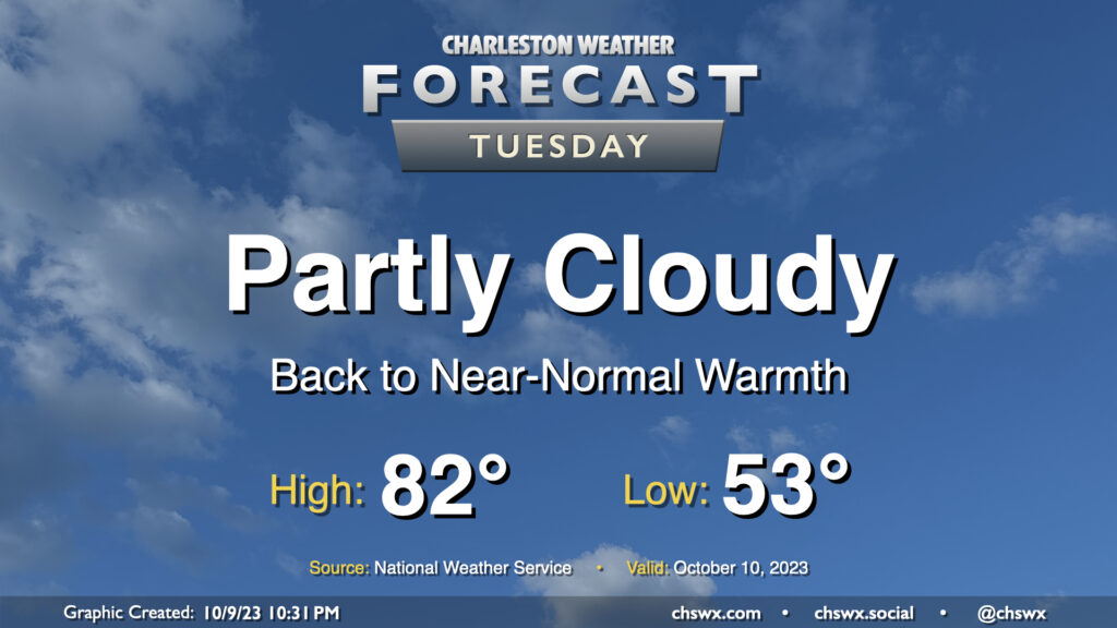
Clouds and temperatures will be on the increase for Tuesday as moisture begins to move back into the area. We start Tuesday in the low 50s before temperatures warm reasonably quickly into the low 80s by early afternoon. We should get plenty of sun for much of the day, though cloud cover will be thickening by evening.
After a day that featured lows in the low 50s and highs topping out just in the low 70s, clear skies and calm winds will allow temperatures across much of the metro area (inland of the coast, anyway) to fall into the 40s for the first time since early May on Monday morning. Sunny skies will prevail throughout the day, and temperatures should reach the mid-70s in the afternoon as a result. Overall, it will be another really nice day across the Lowcountry.
The chill will gradually recede as high pressure shifts offshore during the day Monday. Tuesday will run warmer and a little cloudier, with highs topping out in the low 80s in the afternoon after a mid-50s start. A little more cloud cover works into the area by Wednesday as a jet streak strengthens overhead, which should lead to a few showers later in the day (though there’s a lot of dry air to overcome initially). Shower chances improve into Thursday as low pressure moves eastward out of the Gulf of Mexico. We should see an uptick in cloud cover and a little cooler day as well as high pressure wedges in from the northeast. We’ll stay wedged in for a good bit of Friday, though a warm front should lift northward later in the day. Shower chances will continue and perhaps tick up a bit as the aforementioned warm front gets nearby. A little thunder will be possible, too.
Conditions should gradually improve over the weekend as a cold front gets through late on Saturday, and by Sunday, temperatures head back below normal into the mid-70s under mostly sunny skies. (Frontal timing, of course, will be fine-tuned as the week goes on.)
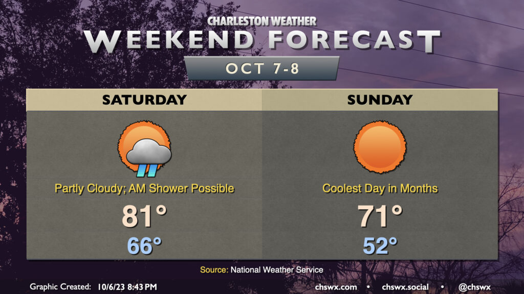
Big (but brief, for now) changes are incoming for our weather in the wake of a cold front that will get through during the day Saturday. First, though, we may dodge a shower or two in the morning as the front gets by, but from there the trend will be for fewer clouds and an uptick in northwesterly winds. We’ll start Saturday in the mid-60s and warm to the low 80s in the early afternoon before cooler air starts to filter in. Dewpoints will drop precipitously starting in the evening, and by Sunday morning, things are going to feel a lot different.
On Sunday, we’ll get off to the coolest start we’ve had since the morning of May 4 with lows bottoming out in the low 50s across the metro. I wouldn’t be surprised to see some 40s in more rural areas. Full sunshine will be in play, but the cooler air moving in will help counteract it, allowing highs to only climb into the low 70s. Bottom line: Take Saturday to make sure your light jackets or hoodies are ready to go because you may very well need them on Sunday! We keep the cooler air going into Monday, but it will be short-lived and we’ll be back closer to normal by mid-next week.