This weekend is looking mostly quiet (weather-wise, anyway). Expect standard mid-June fare across the Lowcountry with highs topping out around 90° each afternoon. Saturday will feel a little drier than we’d normally feel at this point in the year, in fact, with dewpoints mixing out to around 60° in the afternoon. We may see an isolated storm later in the evening, but the vast majority of us stay dry.
It stays mostly that way for Sunday, though we’ll feel a little more in the way of humidity with winds turning more onshore. Once again, a stray afternoon storm is possible, but overall we look to get much of the day in rain-free. Expect highs to once again top out around 90°, with heat indices in the low 90s.
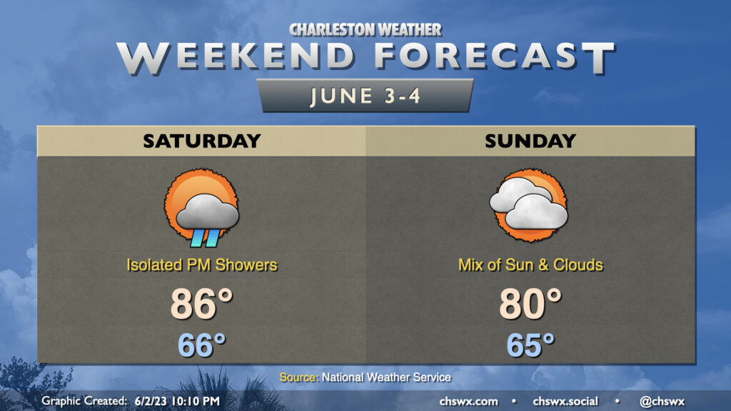
This weekend’s forecast is looking pretty good by 2023 standards, and will certainly be a far cry from what last weekend looked like. Saturday will be the warmer of the two days with highs topping out in the mid-80s in the afternoon. A few showers will be possible along the seabreeze, but those should be few and far between. A cold front moves by overnight Saturday into early Sunday morning, which will usher in some cooler and drier air that’ll keep highs capped around 80° in the afternoon under a mix of sun and clouds. Watch for some breezy conditions in the wake of the front on Sunday, with gusts near 30 MPH possible particularly on elevated surfaces and at the beaches.
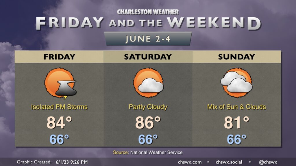
This weekend’s weather looks closer to what we wish we had last weekend. Expect highs to run generally in the mid-80s on Friday and Saturday. A cold front pushes through later Saturday, and this will drive highs a little cooler on Sunday as a result — generally topping out in the low 80s. We’ll start each day squarely in the mid-60s. Overall, these temperatures are below normal for the start of June.
This might be one of the quieter weekends we’ve had rain-wise this far this year. A stray shower or storm is possible Friday afternoon and evening, with lower chances Saturday and Sunday. We’ll see how this evolves, but this might be as close as we’ve gotten to a rain-free forecast for a weekend since early February! Stay tuned.
If you’re looking for a more authentic June feel, highs in the upper 80s look to return to the weather picture — at least briefly — by the middle of next week.
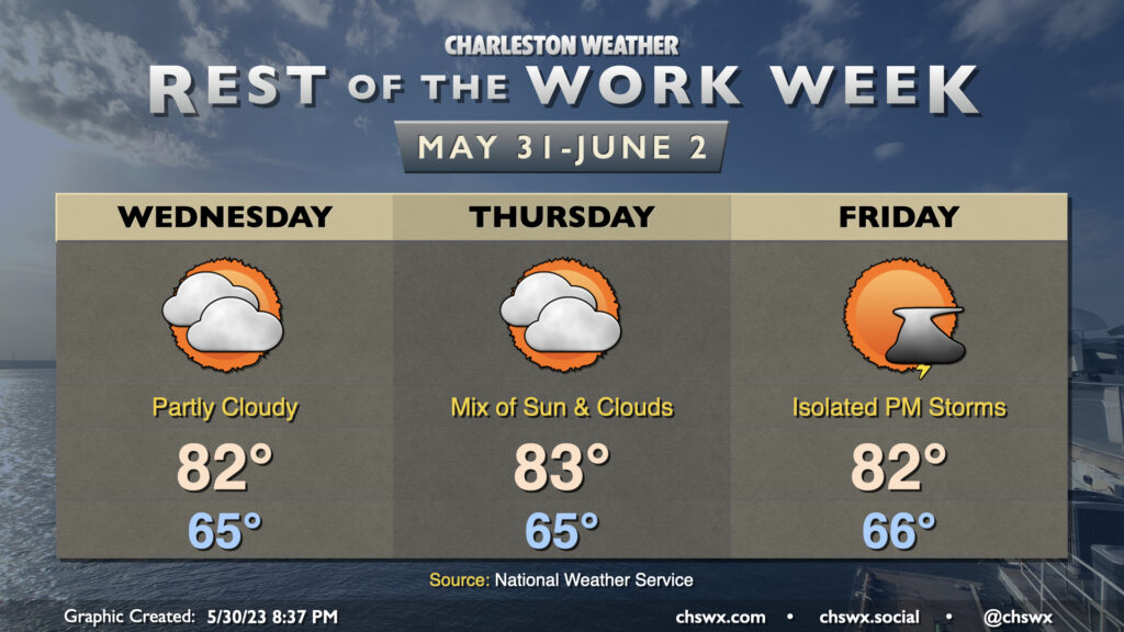
The forecast for the rest of the work week is pretty straightforward: a mix of sun and clouds each day, with temperatures starting the day around normal before topping out a few degrees below normal each afternoon. Highs will generally run in the low 80s after starting each day in the mid-60s, somewhat unusually “cool” for the end of May and beginning of June. Precipitation chances will be minimal Wednesday and Thursday, with a slight chance of an evening thunderstorm on Friday.
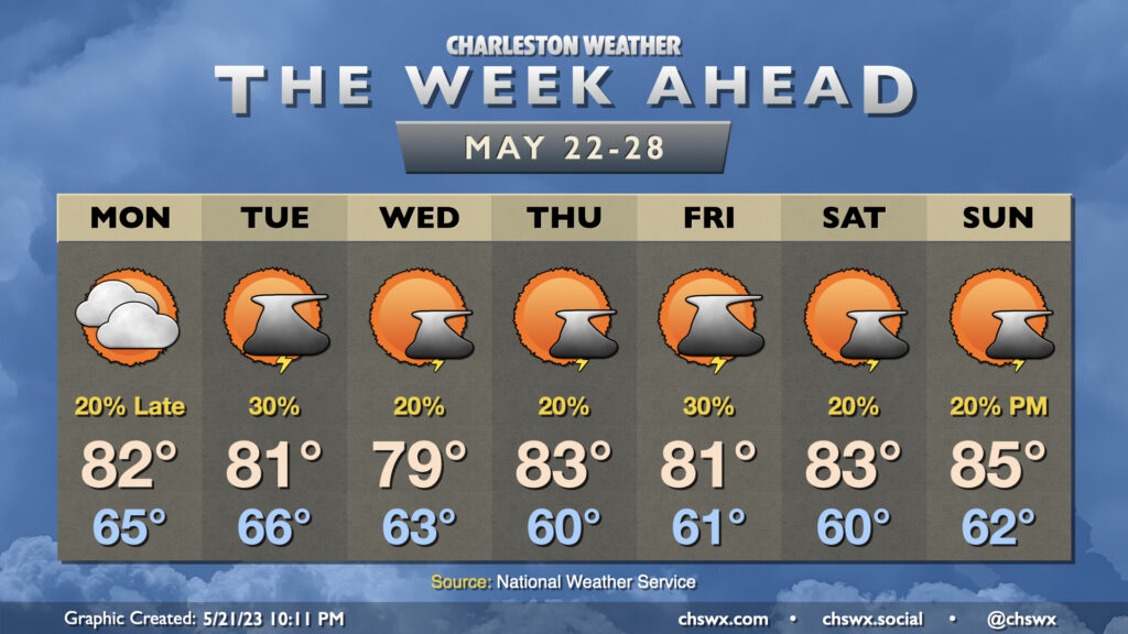
One thing you might notice right away when peering at the week ahead is that temperatures for the week ahead look more like early May as opposed to late May. Highs will generally top out in the low 80s for much of the week (and Wednesday might not even crack 80°!) as cool high pressure builds into the area and stays in force. Upper-level disturbances swinging through will keep isolated to scattered thunderstorm chances in the forecast, primarily in the afternoons (though some popup showers can’t be ruled out in the mornings, either).
The second half of the week will have some details to iron out regarding an area of low pressure that will move northward, parallel to the coast. The question ultimately is how far west it gets; it may spread some gusty rains ashore Thursday into Friday if it gets a little too close. Stay tuned for forecast updates.
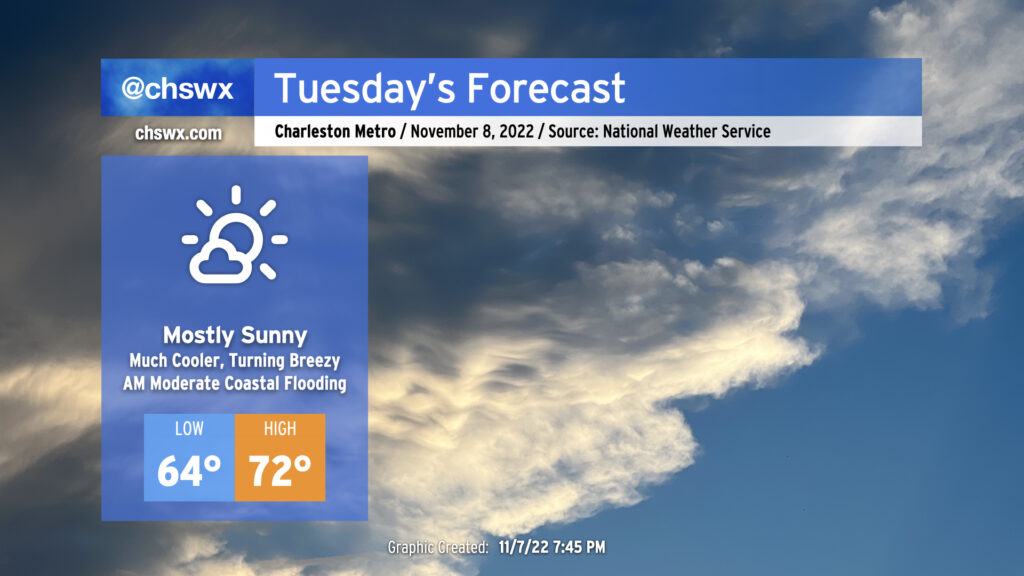
Election Day will feature rain-free conditions, plenty of sunshine, and much cooler temperatures as high pressure to the north wedges into the area. This will definitely feel a lot different than the mugginess we’ve had for the past week-plus. You’ll want to keep a jacket around, too, as winds become gusty as the pressure gradient between the high building in from the north and Subtropical Storm Nicole to the south intensifies. Watch for gusts upwards of 25 MPH away from the coast, with gusts 30-35 MPH possible at the beaches.
The last total lunar eclipse of 2023 — and last one visible from the US until 2025 — will peak tomorrow morning just before 6am. The moon will be getting lower on the horizon in the western sky, but cloud cover should be sparse for eclipse viewing.
The full moon will also be a contributor to elevated water levels in Charleston Harbor with the 7:31 AM high tide, which is expected to peak around 7.6′, producing minor to moderate coastal flooding. This may have some impacts on the morning commute for folks traveling around downtown Charleston. Be ready to use alternate routes in case you encounter flooded or closed roads.
Mariners should take note that a Tropical Storm Warning has been hoisted for the coastal waters (not the harbor, yet) with very rough marine conditions expected to develop due to the aforementioned pressure gradient. There are no land-based tropical headlines as of this writing.
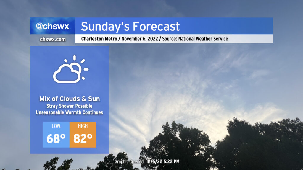
We’ve got another unseasonably warm day on tap for Sunday as an anomalously strong ridge of high pressure aloft continues to extend into the Carolinas. High clouds will favor prominently well ahead of a cold front to our west, but that won’t act as much of a governor on temperatures with low 80s still expected in the afternoon. Indeed, onshore flow is likely going to be the only thing keeping us from approaching the record high of 87° set in 2003.
The morning warmth is almost more remarkable: lows in the upper 60s are forecast, which is getting close to 20° above normal for this point in the year. We should fall shy of the record high minimum temperature of 71° set in 2003, but it does look like we’ll give the record a good run for the money.
A stray shower or two can’t be totally ruled out, but we’ll stay sandwiched between the front to the west and better instability and convergence over the waters and should stay dry as a result.
Finally, minor coastal flooding will be possible with the 6:05 AM high tide as we approach a full moon on Tuesday. Water levels approaching 7′ in the harbor could put some salt water on roads around Gadsden Creek once again — think Fishburne and Hagood — as well as spots along Lockwood (both Drive and Boulevard).
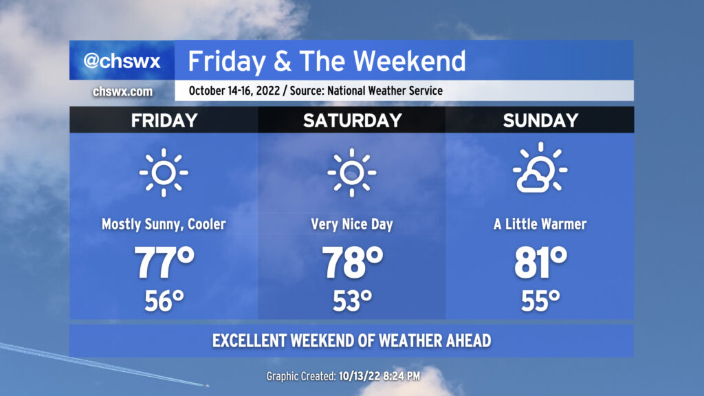
No weather worries as we head into Friday and the weekend as comfortable temperatures take hold behind a cold front coming through overnight.
Friday looks outstanding. Lows in the mid-50s will rebound to the mid-to-upper 70s under full sunshine. Dewpoints below 50° (away from the coast, anyway) will keep things quite comfortable. Winds behind the front will be generally light, generally around 5 MPH from the north. Friday could be one of those rare Severely Nice Weather Alert Days around here, that’s for sure.
Saturday could also qualify as a Severely Nice Weather Alert Day. We’ll start a little cooler — low 50s will be common away from the warmer coastline — and head into the upper 70s under continued uninterrupted sunshine. Winds will be quite light, generally out of the east.
We begin to turn a touch warmer on Sunday as winds go southwesterly ahead of our next front. (More on that in a minute.) Temperatures will run in the low 80s with a few clouds in the afternoon. Sunday’s weather remains excellent, though, and will be a little more palatable to those who like it a little warmer. Something for everyone this weekend!
Overnight showers and thunderstorms will begin to taper off as we head toward daybreak Thursday. We may deal with some slick roads in the morning, though, so be ready for that possibility for your commute. The good news: We’re done with the recent round of tidal flooding induced by the full moon and onshore winds, so no concerns there.
The cold front will be moving through the state throughout the day and won’t clear the area until after sunset Thursday. Ahead of the front, a few showers and thunderstorms could redevelop as temperatures recover into the low 80s in the afternoon. Drier air punching into the area will modulate that threat somewhat, but don’t be surprised to see a shower or storm in your neck of the woods in the afternoon.
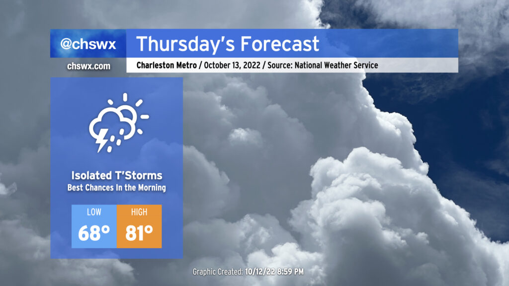
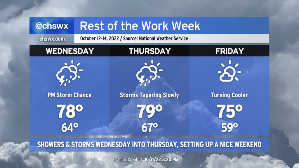
The weather will take a turn more toward unsettled starting Wednesday afternoon as some upper-level energy well out ahead of a cold front helps to induce some showers and thunderstorms across the area.
Wednesday will start fairly mild with lows in the mid-60s thanks to persistent cloud cover. Winds will stay onshore, but despite this, we should still top out solidly in the upper 70s in the afternoon ahead of thunderstorms. It certainly seems that we may get a majority of the day in rain-free, with rain chances starting to head up around commute time.
The greatest risk for showers and thunderstorms looks to be after sunset through early Thursday morning. It’s likely we’ll get a good bit of Thursday morning in rain-free, allowing highs to top out near 80° in the early afternoon. Then, it’s possible that some showers may redevelop ahead of the cold front itself as its timing should coincide with peak heating. The front gets through Thursday evening, and by Friday, we’re starting out quite a bit cooler — upper 50s as opposed to mid-to-upper-60s — with highs topping out in the mid-70s under quite a bit of sunshine. This will set up a beautiful weekend of weather with plenty of sunshine and comfortable temperatures, though perhaps not quite as cool as mentioned yesterday. Still, though, mid-to-upper 70s remain below normal for highs for this point in October.