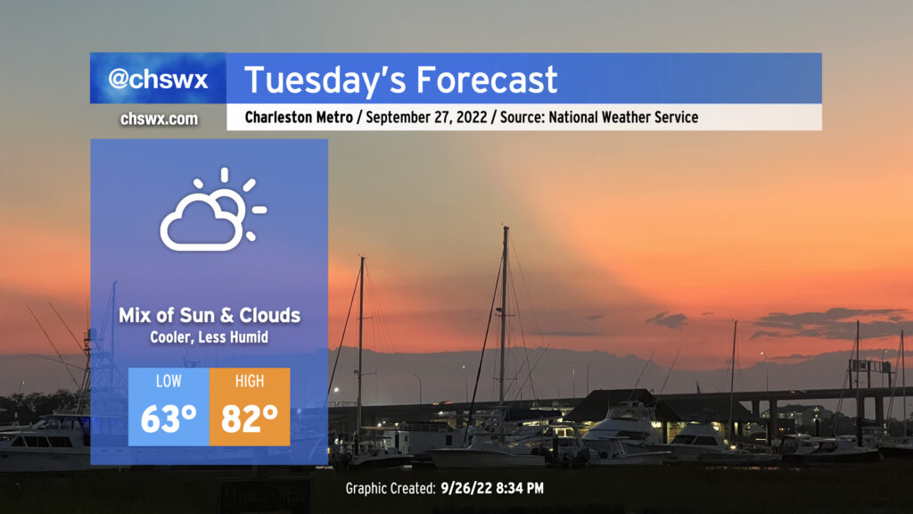
We’ll turn cooler tomorrow as a front gets through tonight. Expect lows to run a few degrees lower in the mid-60s (a touch warmer near the coast where water temperatures still hover around 80°). Highs will get to the low 80s under a mix of clouds and sun as high pressure wedges in from the northeast. It’ll be a good day to get prep work done ahead of Ian, which continues to look to produce impacts in the Lowcountry later this week.
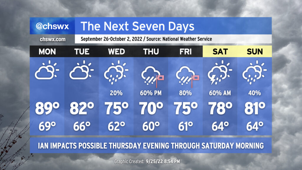
The week ahead will be punctuated by rough weather conditions courtesy of what is currently Tropical Storm Ian, which is finally beginning to intensify as I write this. It is expected to intensify into a major hurricane by as early as Tuesday morning, head over the western tip of Cuba, and then into the Gulf of Mexico where it moves up peninsular Florida’s Gulf Coast on the way to a landfall late Thursday/early Friday.
The week starts out innocuously enough; highs will head toward 90° on Monday ahead of a cold front which will push southeastward across the area throughout the day with maybe a shower, but the vast majority of us stay dry. Said front will knock Tuesday’s highs back to the low 80s under partly to mostly cloudy skies as high pressure wedges southward into the area. The front that got through Monday will then stall out and begin to retreat northwestward as a warm front on Wednesday as Ian approaches Florida. This could help spread a little shower activity in our direction, but otherwise expect mostly cloudy skies and significantly cooler temperatures — highs topping out only in the mid-70s underneath increasingly breezy northeasterly flow as the gradient between Ian to the south and high pressure centered to our north begins to tighten.
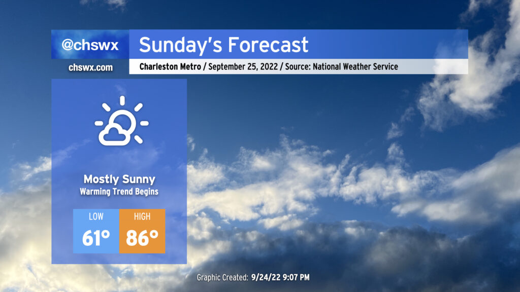
We’ve got another nice-looking day of weather coming up for Sunday. We start the day a little warmer than we did Saturday — lows generally around 60° away from the locally warmer coast — but it’ll still feel nice and fall-like to start the day. High temperatures will head up into the mid-80s in the afternoon under mostly sunny skies; southwesterly winds will bring a little more in the way of humidity into the picture as well, but dewpoints in the mid-60s will still feel alright.
Sunday marks the beginning of a brief warming trend that’ll see us head into the upper 80s on Monday ahead of another cold front. That front should pass with minimal fanfare, though a shower or two can’t be totally ruled out Monday evening. This will set us up for a nice day of weather on Tuesday, with highs in the low 80s expected.
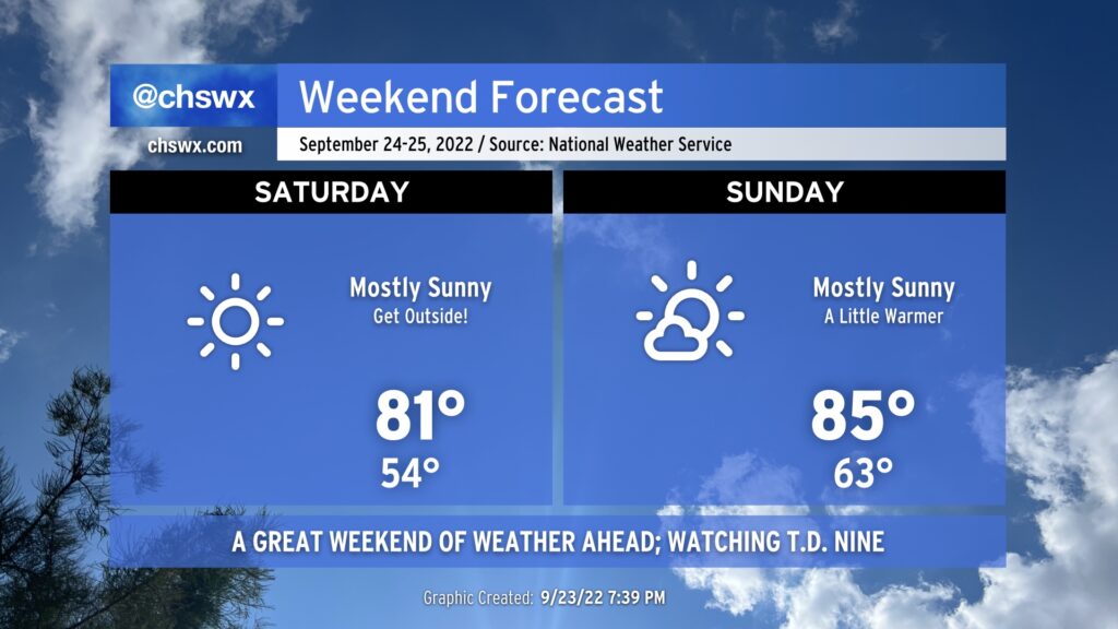
High pressure will dominate the pattern this weekend, bringing us excellent weather for outdoor activities.
Saturday will start out as cool as it’s been since mid-May, with lows expected to bottom out in the mid-50s away from the locally warmer coast. Cloud-free skies should persist for much of the day as temperatures head to the low 80s in the afternoon. Winds will be down compared to what we saw Friday, too, which should make it a little easier to enjoy a meal outdoors with a lower risk of unintentional napkin aviation.
High pressure will begin to slip offshore Saturday night into Sunday, and this will make Sunday’s start feel about 5-10° warmer on average across the area with lows bottoming out around the mid-60s. Mostly sunny skies will persist, though, and highs will generally top out in the mid-80s. It’ll be a touch more humid, but certainly not anything tremendously uncomfortable.
The only hazard we’ll need to really be concerned with this weekend is a lingering high risk for rip currents thanks to continued swell from Hurricane Fiona. Inexperienced swimmers should continue to avoid the Atlantic waters this weekend as a result.
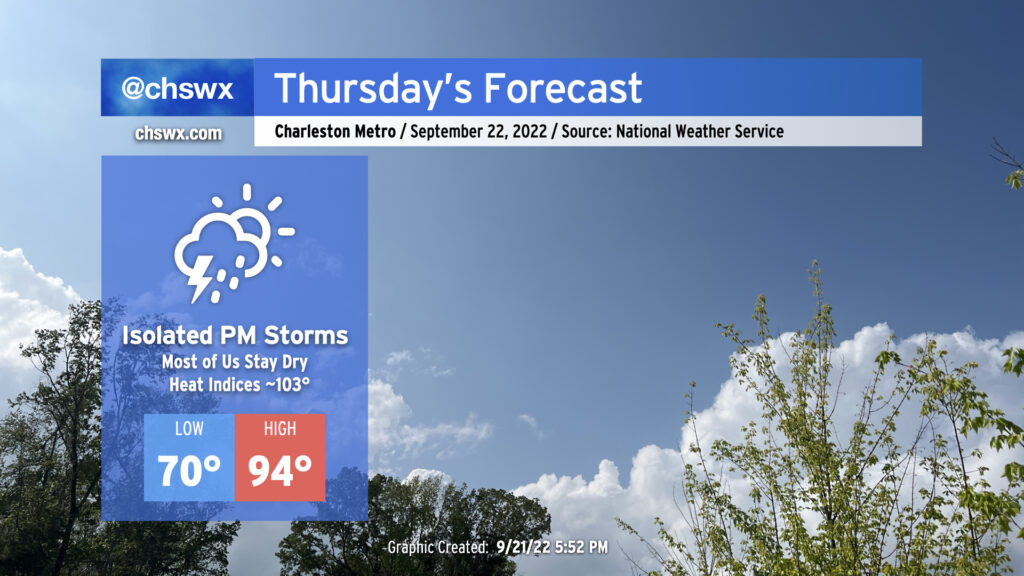
We’ve got one more hot day in store for Thursday before the weather takes a turn for the fantastic for Friday and the weekend. Compressional heating ahead of a cold front will drive highs into the mid-90s for Thursday afternoon, perhaps approaching the record high of 96° set in 1990 at the airport. Downtown could very well tie or break the record high of 92° set in 1925, too. Mix in a little bit of humidity and it’ll feel closer to the upper 90s (though heat indices should stay south of 100° as the deep-layer dry air helps to mix out dewpoints to the mid-60s). There will be a slight chance of showers and thunderstorms in the late afternoon and early evening hours as the front passes by, but don’t expect anything too heinous as there’s still plenty of dry air to overcome for much in the way of active weather.
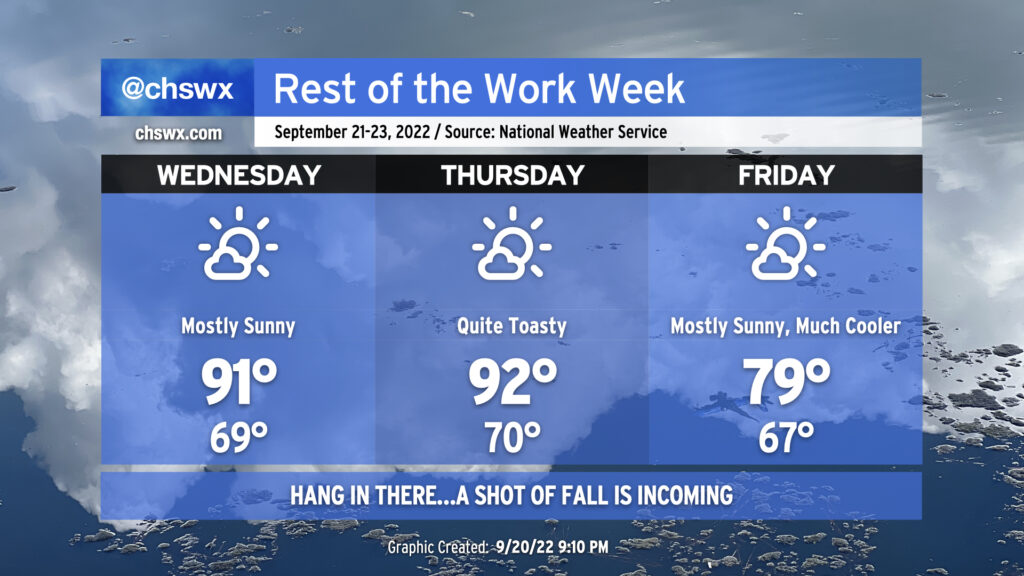
Quiet weather continues for the next several days as high pressure and drier air aloft keep any risk for precipitation very, very low. We’re also staying hot: we reached 91° today and look to do similar numbers for Wednesday under mostly sunny skies. Thursday will be even warmer, with highs reaching the low-to-mid-90s and humidity pushing the heat indices a few degrees warmer.
The heat will break, though, as a cold front swings through late Thursday/early Friday morning. This cold front is legit (and has a great sense of timing, with the autumnal equinox occurring at 9:03 PM Thursday), with a cooler and drier airmass working into the area that’ll knock high temperatures down 10-15° over the previous day. The current NWS forecast doesn’t even crack 80° on Friday! Feels like forever since we’ve had a high that low without any rain, and it will feel quite nice leading into what’ll be an exceptional weekend of weather with mostly sunny skies and seasonable, below-normal temperatures. Hang in there…relief from the heat is coming!
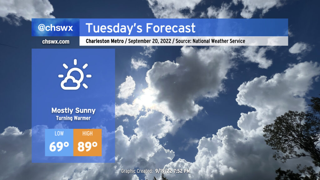
Tuesday will kick off a period of quiet and warming weather as expansive high pressure at the surface and aloft builds into the region from the west. This’ll put the lid on much in the way of cloud cover, much less thunderstorm activity, allowing temperatures to approach 90° in the afternoon. Humidity won’t be terribly heinous, but will be enough to push the heat index to around 92° or so. Temperatures, especially highs, will run several degrees above normal through Thursday (which could approach the mid-90s) before a trough digs in to our north and drives a cold front through, which will make for a rather pleasant Friday and weekend of weather. (Not that I’m counting down or anything.)
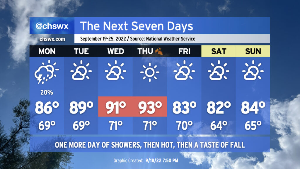
It’ll be a tale of two seasons this week — both figuratively and literally — as we reach the autumnal equinox on Thursday to usher in astronomical Fall. Summer’s gonna have one final parting shot, though, as a ridge expands across much of the southern US during the middle of the week.
We’ll still be dealing with a pesky coastal trough on Monday, which will toss some occasional showers and maybe a thunderstorm ashore. Temperatures will head up to the mid-80s away from the immediate coast; humidity will make it feel more like the low 90s. As the aforementioned ridge of high pressure builds in, though, the coastal trough will move away from the area, setting us up for a warm stretch mid-week. Tuesday’s highs will approach 90° as northerly to northwesterly flow aloft keeps cloud cover to a minimum. We get even hotter for Wednesday, with highs in the low 90s expected. Thursday’s going to be the hottest day of the set as compressional heating ahead of a cold front pushes temperatures close to the mid-90s — not quite meteorological conduct becoming of the first day of fall. Dry air in the area will limit cloud cover, much less any thunderstorm activity, so don’t count on that for any relief.
What we can count on, though, is the cold front to actually bring in a decent airmass change. Cooler and drier air will punch into the area overnight Thursday into Friday as the cold front gets through. We’ll start Friday on the warm side, but cool advection will kick in and keep temperatures from getting much warmer than the low 80s in the afternoon. The weekend is looking quite excellent, with a northeasterly breeze keeping temperatures a bit below normal for this point in the year and cloud cover to a minimum. We’ve just gotta get through this hot stretch first.
A coastal trough will bring our first mentionable shower and storm chances in a few days for Sunday as a few showers and thunderstorms could drift ashore from time to time. While some of the high-resolution guidance has been awfully aggressive about rainfall amounts and how far inland measurable rain gets, generally expect the best chance for any showers toward the coast. An isolated downpour can’t be ruled out particularly if deeper moisture can make it ashore. With all that said, the rain chances are far from substantial enough for canceling any outdoor plans — just keep an eye out tomorrow in the unlikely event a storm approaches.
Temperatures will continue to run right around normal for this point in the year. We’ll start the day in the mid-to-upper 60s across much of the metro (low 70s at the beaches) before temperatures head up to the mid-80s in the afternoon. Dewpoints are forecast to approach 70° in the afternoon, and that’ll yield heat indices in the low 90s at peak heating.
We’ll see similar conditions on Monday before a ridge of high pressure asserts control at the surface and aloft. We’ve got a few hot days in store next week, with air temperatures in the low 90s possible mid-week as we reach the autumnal equinox and Fall begins. A dry front will usher in a shot of cooler and drier air just in time for the weekend, though. NWS’s opening bid for next Saturday: Low 66°, high 81°, mostly sunny skies, dewpoints in the low 60s. (Can we fast-forward?)
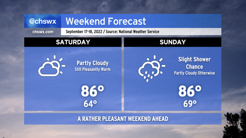
We’ve got a pleasant weekend ahead, despite humidity creeping back up for Sunday with the specter of a stray shower or two in the mix.
Saturday’s the pick day, in my view: it’ll be the last day of the lower humidity we’ve been experiencing over the past few days, which will keep that high of 86° feeling like it’s 86°. On Sunday, we’ll see a little bit more in the way of humidity working back into the area as dewpoints creep back up to around 70° in the afternoon, causing that high of 86° to feel closer to 90-91°. A stray shower isn’t out of the question, but the vast majority of us look to stay dry.