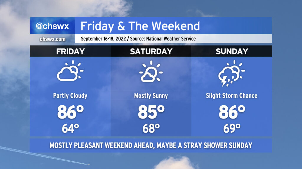
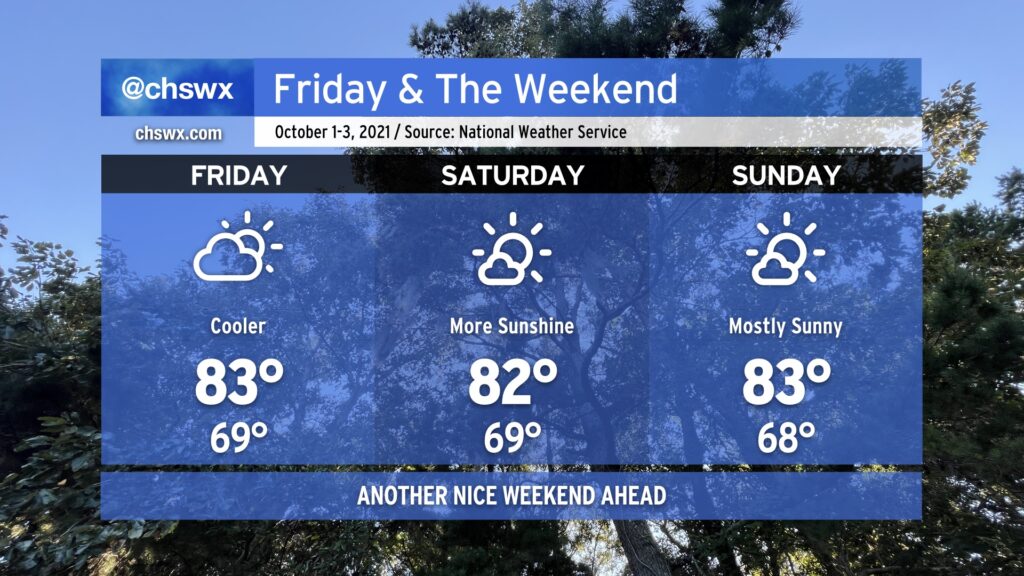
We’ve got a much nicer-looking weekend ahead than we had last weekend as a few more days of comfortable temperatures and generally quiet weather continue across the area. Partly cloudy to mostly sunny skies will generally be the rule each day. We start Friday back in the mid-60s for one more day before dewpoints begin to creep up heading into the weekend, nudging lows up to the upper 60s for Saturday and Sunday. Highs, though, will remain in the mid-80s — right at normal for this point in the year.
Sunday’s looking like the only day that could see a little shower and storm activity. A wave of low pressure is expected to form along a stationary front well to our south, with a coastal trough developing on its northern flank. This may be enough to push a few showers and storms inland from the Atlantic, but rain chances are slight at best; many of us should stay rain-free. Otherwise, though, quiet weather looks to persist well into next week as ridging develops aloft. Temperatures will warm a bit more under this ridge, and it’ll feel a touch more humid with dewpoints climbing to around 70° beginning Saturday night and Sunday, but rain chances remain next-to-nothing heading into next week. (We’ll take all the drying out we can get.)
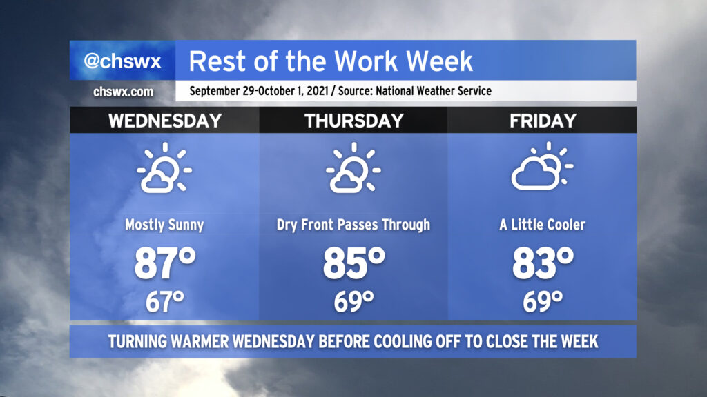
We’ve got a really nice weather day coming up for Thursday. We’ll start the day in the mid-60s away from the coast (where the warmer water temperatures will keep lows above 70°). Temperatures will head into the mid-80s under mostly sunny skies with a northeasterly breeze keeping things feeling seasonable. Meanwhile, dewpoints will mix out to around 60°, making for a very comfortable afternoon. All in all, it should be a really nice day to get out and about a bit as you can — I’d certainly recommend it.
Pleasant weather will continue for Friday into the weekend, too. A coastal trough could help get a shower or two toward the area on Saturday and Sunday, but otherwise, expect rain-free conditions and seasonable temperatures.
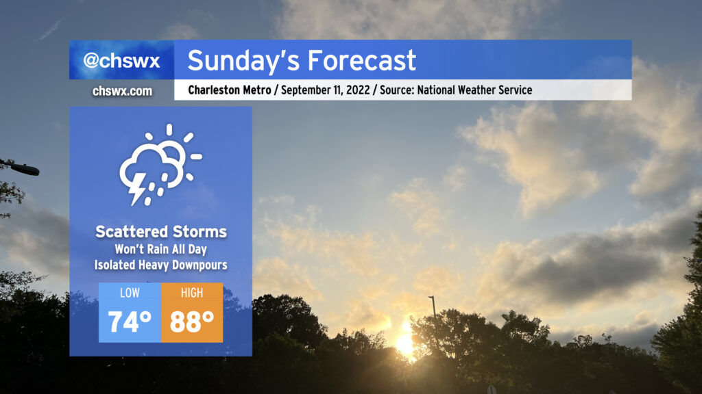
Expect another round of scattered showers and thunderstorms for Sunday as moisture continues to pump into the area from the Gulf and beyond. We may see some pre-sunrise showers and storms in the area to start the day, but the greater probability of precipitation will arrive in the afternoon as the seabreeze begins trekking inland and thunderstorms get rolling. Heavy rain and lightning will be the main concerns for any thunderstorm that develops. Once again, don’t expect it to rain all day at any one location — just be ready to move outdoor activities inside if thunderstorms approach.
Given the scattered cloud cover, expect temperatures to head into the upper 80s in the afternoon. Mix in the humidity, though, and it’ll feel closer to 100-102°. Given just how much rain has fallen in the last few days, too, grassy areas without much tree cover may be especially heinous.
Elevated rain chances continue for Monday, but we will start to see a bit calmer weather Tuesday and especially Wednesday before a front stalls out nearby Thursday, which will bring some scattered rain chances back into the picture — though right now, it looks nothing like we’ve been experiencing recently.
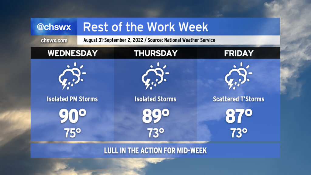
As we head into mid-week and look to round the corner toward Labor Day weekend, we’re going to see a reduction in shower and thunderstorm coverage for a few days as some drier air aloft works in from the north and west. We’ll keep isolated to scattered shower and thunderstorm chances in the forecast as those probabilities won’t be totally eliminated, particularly near the coast, but we shouldn’t see the sustained flooding rains that have been a concern the past couple days. Areas further inland could even see a rain-free couple days, especially on Thursday as a front clears the area and stalls to our south.
As rain chances diminish, temperatures turn back up to a little above normal as we close out August and enter September. Expect highs around 90° for Wednesday; mix in the plentiful humidity and it’ll feel closer to 100-102°. Thursday will run pretty warm, too, with highs around 90° and heat indices in the upper 90s once again expected. Rain chances begin to tick back up on Friday, and that’ll lead to high temperatures topping out a little lower than the previous couple days, generally in the mid-to-upper 80s.
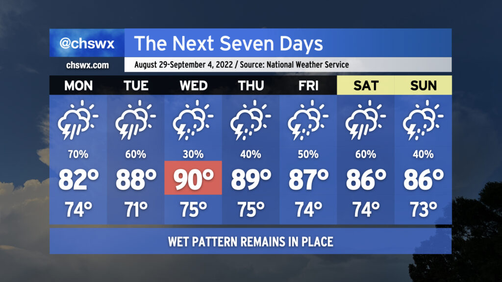
More wet weather is on the way as we remain in a rather unsettled pattern heading into the first days of September (and meteorological fall!)
We’ll likely start Monday with showers and maybe some thunderstorms in the metro area as offshore storms make a run to the coast. Be ready for a somewhat complicated commute due to rain. It’ll be worth watching downtown around high tide just before 10am, too, for the potential for heavy rain to combine with said tide to possibly produce some street flooding. Storms and their associated pockets of heavy rain will continue to spread inland throughout the day. Rain and cloud cover will keep temperatures suppressed to the low 80s.
We stay unsettled heading into Tuesday as a front moves toward the area. Thunderstorms will become likely once again in the afternoon, though temperatures will have a little more time to rebound into the upper 80s. Expect more scattered coverage Wednesday as a little drier air aloft moves in, which will allow temperatures to head into the low 90s in the afternoon ahead of the front. The front moves by Thursday and stalls out to the south, which will help keep moisture in place and the risk for showers and thunderstorms in the forecast as we head into the Labor Day weekend. As is customary for late summer, there will not be any day that’s a total washout — just have backup plans for any outdoorsy things you might have going on.
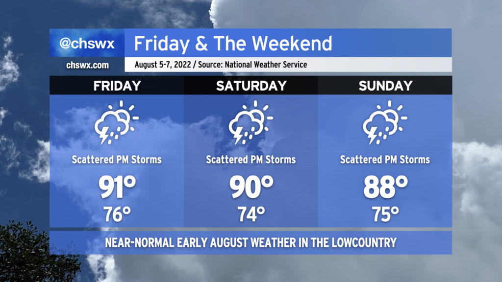
Atlantic high pressure keeps us appropriately warm and muggy by early August standards for tomorrow into the weekend. Onshore flow will help air temperatures run in the upper 80s to low 90s each afternoon, while humidity will make it feel closer to the upper 90s and low 100s.
The aforementioned onshore flow keeps a chance of showers in the forecast Friday morning closer to the coast. Rain chances will migrate inland with time, with a few thunderstorms possible as the seabreeze pushes inland across the area during the afternoon and early evening hours. Saturday’s setup looks similar, too, though the NAM nest is a little less excited about morning showers. Sunday could be a little more active as what looks like a weak TUTT (tropical upper-tropospheric trough) whirls into the area from the east, helping to enhance shower and storm coverage across the area. Overall, the risk for severe weather remains low, but as always, lightning makes every thunderstorm dangerous. When thunder roars, go indoors!
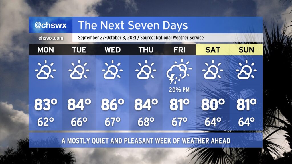
All in all, expect another nice weekend across the Lowcountry as a little cooler air works down into the area over the next few days. Temperatures will generally top out in the low to mid-80s across the area, with lows in the upper 60s inland and the low 70s near the coast. Aside from a small risk for a shower or storm tonight, particularly in the upper reaches of the Tri-County, our next appreciable rain chance doesn’t arrive until next Tuesday.
The tropics remain busy, but Hurricane Sam and recently-minted Tropical Storm Victor are staying out to sea and are not threats to the Lowcountry. We may see some enhanced rip current risk and wave action from Sam over the next few days, so be aware of this risk if the beach is in your plans. Otherwise, no concerns. Fingers crossed it stays this way — we’ve got two months to go in what has been a very busy 2021 hurricane season.
The temperature curve is very much respecting Wednesday as Hump Day with highs topping out in the upper 80s, as high as they’ll get this week before gradually coming down for Thursday and Friday as a dry cold front sinks south across the area. Mornings will remain a little on the warmer side, with upper 60s to low 70s common across the metro area, warmest near the beaches and coolest inland.
We’ll remain rain-free despite a front coming through Thursday as moisture remains in limited supply. In fact, the first appreciable rain chance we’ve seen in more than a week will probably arrive on Monday or Tuesday, and even then right now the chances are pretty slim.
The tropics remain busy as Hurricane Sam continues to churn in the Atlantic. There are also two areas of interest in the far eastern Atlantic that are very likely to exhaust the primary name list for the second consecutive season, but neither those areas nor Sam are a threat to the Carolinas as we move into October.
We will close out September with a weather winning streak intact. Temperatures will gradually moderate into the mid-to-upper 80s as we get into midweek with mostly sunny skies each day. We could see a front swing through later in the week; while it will be moisture-starved, it might be able to squeeze out a storm or two. Then, back into the low 80s for the weekend, with mostly sunny skies prevailing. Not a bad way to close out the month and head into the fourth quarter of 2021 (already!).
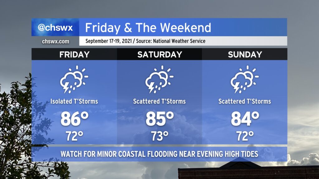
We will remain in a warm and muggy regime on Friday into the weekend as tropical moisture remains in place over the area. We should see a little less shower and storm coverage on Friday as compared to today without much in the way of forcing, but a few airmass thunderstorms will be possible especially ahead of the seabreeze. Saturday looks similar right now as forcing mechanisms remain few and far between. Heading into Sunday, though, upper-level energy will rotate into the area, and this should help enhance shower and thunderstorm coverage especially in the afternoon and evening hours. A total washout is not in the cards, though, so don’t go torching your weekend plans — just keep an eye on the forecast as there will be adjustments and fine-tuning throughout the weekend.
Temperature-wise, we’ll remain generally in the mid-80s each afternoon after starting out in the low 70s each morning (with perhaps some upper 70s to around 80° lows close to the coast, including downtown). Temperatures should be knocked down a peg for Sunday given more expansive cloud cover and shower and thunderstorm activity in the region.