Jared Smith founded @chswx on Twitter in 2008 as an experiment in disseminating weather data through social media. In the ensuing decade-and-a-half, @chswx has provided live coverage of tropical cyclones, tornadoes, severe weather, and even a couple bouts of winter weather to the good people of Charleston, SC.
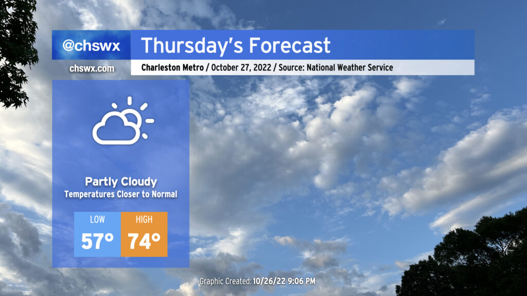
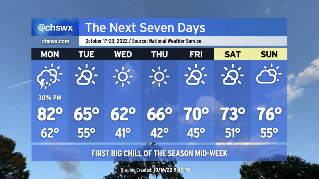
A cold front is on its way through this evening, which will bring cooler temperatures for Thursday and beyond after highs peaked in the low 80s this afternoon away from the locally cooler coastline. Winds will go to the north and then the northeast overnight as high pressure builds in from the north and west. We’ll generally see scattered clouds throughout the day with those northeast winds keeping us about 5-7° cooler than we saw Wednesday. The aforementioned northeasterly winds and upcoming lunar perigee will contribute to another risk for minor to moderate coastal flooding around the 9:47am high tide, so be aware of the potential for closed roads once again tomorrow morning (though the peak of any tidal flooding should miss the bulk of any commute time at this point).
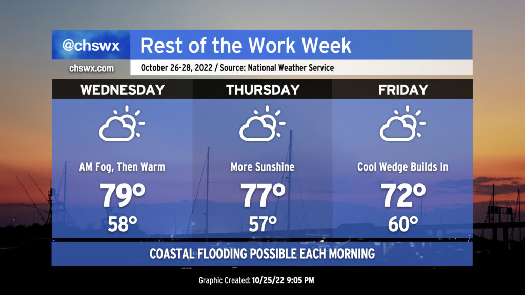
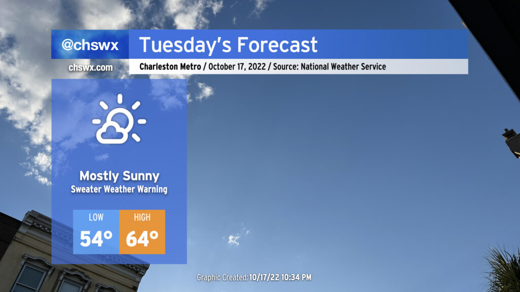
We look to get off to another foggy start Wednesday morning, at least in spots, as temperatures bottom out just shy of 60° in the morning. We may not see quite the density nor the duration that we saw Tuesday morning, but still, be ready to use those low beams and allow extra time to get where you are going. Once any fog burns off, warm advection ahead of a cold front will help temperatures get to near 80° in the afternoon under partly cloudy skies.
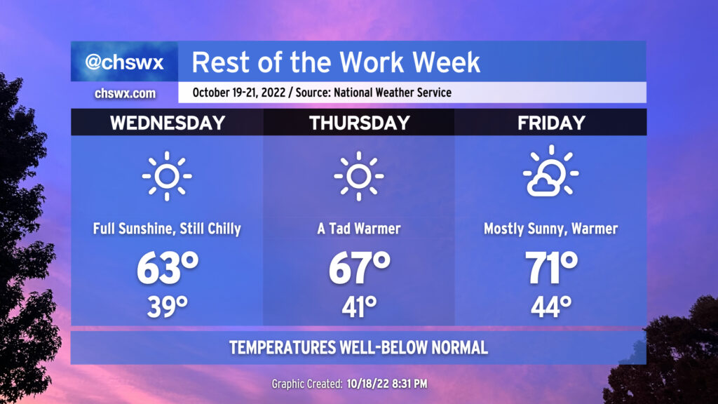
The front gets through late Wednesday. It looks like it’ll get through mostly rain-free given limited moisture. Once that happens, winds will go around to the north and northeast and begin to bring some cooler air into the area. The persistent northeast winds will cool things down even further for Friday as highs only top out in the low 70s as cloud cover builds within a strengthening wedge of high pressure.
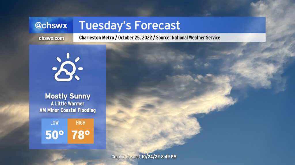
We’ll continue our warming trend on Tuesday ahead of a weak front that’ll come through later Wednesday. After starting around 50° thanks to clear skies and light winds, we’ll warm well into the upper 70s in the afternoon. We should see mostly sunny skies for a good bit of the day, with some higher clouds beginning to thicken later on. Rain-free conditions continue, and it should overall be another good day of weather across the area.
The only weather hazard of note will be the risk for some minor coastal flooding around the 8:20 AM high tide. Right now, water levels are forecast to peak around 7.1-7.3′ in the harbor, which will be enough to perhaps close a couple of the more vulnerable roads on the Charleston peninsula (such as around Hagood and Fishburne as well as near the City Market).
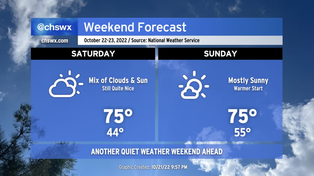
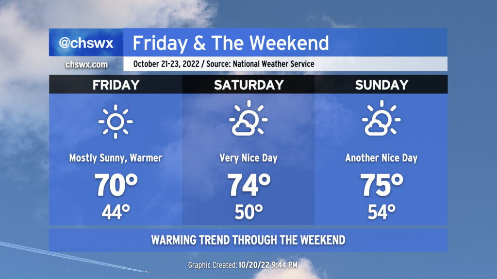
Really not much to write home about weather-wise this weekend: Seasonable weather is in store for the weekend with passing clouds from time to time. Saturday gets us off to a cool start with lows bottoming out in the mid-40s before highs recover to the mid-70s with passing clouds. Sunday gets off to a slightly warmer start in the mid-50s as highs warm back into the mid-70s in the afternoon with a little more sunshine. All in all, no concerns — get out and enjoy!
We’re back to the 70s starting Friday as the chilly airmass that’s brought us a couple mornings in the 30s continues to moderate. You’ll still want a hoodie in the morning as lows bottom out in the mid-40s, but it won’t be quite as cold as the past two mornings. The forecast high of 70° is still several degrees below climatology for this point in October, though.
We turn even warmer for the weekend. Lows in the 50s are anticipated for Saturday & Sunday, with highs in the mid-70s expected both days with just a few clouds from time to time. It’ll be another great weekend to get out and about.
You’ll be hard-pressed to find much in the way of rain for the foreseeable future; the extended NWS forecast remains quite dry, with a small chance of a shower or two mid-week as a weak front passes by. Temperatures will climb to slightly above normal for early next week before the front cools things off slightly.
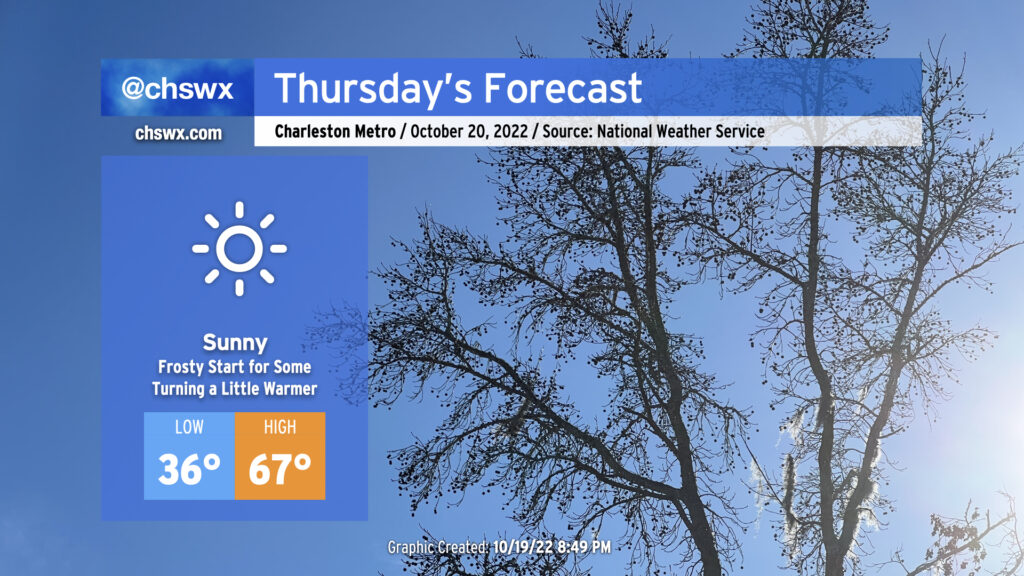
Some of us are going to get off to a frosty start on Thursday as temperatures fall into the mid-30s overnight, perhaps threatening the record low of 34° set in 1981. A Frost Advisory will be in effect from 4-9am for inland Berkeley and Dorchester counties as this is where temperatures are most likely going to be low enough to support frost formation. I don’t know that I could totally rule some patchy frost out a little further eastward as well in more sheltered spots. Bring in plants and pets tonight to be safe.
From there, full sunshine will begin to modify the chilly airmass that’s been in place over the past couple days. Highs Thursday afternoon will still run well below climatology for this point in October, but will be a few degrees warmer than we felt Wednesday, topping out in the mid-to-upper 60s. (More on Wednesday’s temperatures in a sec.)
Be ready to don the sweaters as the coolest air of the season thus far has arrived. This will be quite evident Wednesday morning, as many of us away from the coast could feel temperatures below 40° for the first time since early April. Despite full sunshine, temperatures will only top out in the low 60s in the afternoon.
Thursday will continue to run features well below normal. We’ll once again flirt with 40° in the morning. Temperatures in the afternoon should run a few degrees warmer as cold air advection shuts off and the airmass begins to modify with continued nearly-unfettered sunshine, but we’ll still only top out in the mid-to-upper 60s.
We look to return to the low 70s on Friday as temperatures continue to warm heading into the weekend. Copious sunshine will continue, though perhaps with a few more clouds dotting the skies than in the previous two days. Good weather looks to continue into the weekend, too, with temperatures warming closer to mid-to-late October norms (mid-70s).
A cold front will move through overnight, ushering in the first really solid chill of the season for the Lowcountry. Morning lows will bottom out in the mid-50s, while cold advection within a northwesterly breeze will only allow temperatures to rise to the mid-60s in the afternoon despite almost full sunshine. These high temperatures will run some 10-15° below normal for this point in October, matching the very cool high temperatures we experienced during Hurricane Ian at the end of September (minus the hurricane part).
Temperatures are the main weather story this week as the first legitimate sweater weather of the autumn arrives Tuesday in the wake of a strong cold front. Highs on Monday will be in the low 80s for the last time for the foreseeable future; once the front is by, we begin a stretch of well-below normal temperatures. Highs top out only in the 60s for Tuesday through Thursday. Wednesday looks to be the coldest day since early April, with lows bottoming out around 40° and highs only topping out in the low 60s despite full, unfettered sunshine. From there, temperatures will moderate, with highs returning to the 70s by Friday into the weekend.
So far, there is a risk for scattered showers and thunderstorms Monday afternoon and evening as the front moves by. A stronger storm or two can’t be completely counted out given good wind shear and decent thermodynamics, but some dry air should limit coverage. If stronger storms do form, gusty winds and maybe some hail are the main threats. After that, we look to remain rain-free for much of the rest of the week.
The forecast for the weekend is complicated by some signals that a coastal low could develop and move northward, bringing us some unsettled weather. There’s a lot of model disagreement on where the low forms, if it even forms at all. For now, the NWS forecast is for a reasonably warm, rain-free weekend, but keep an eye on updates as more guidance comes in throughout the week as revisions are possible.