Jared Smith founded @chswx on Twitter in 2008 as an experiment in disseminating weather data through social media. In the ensuing decade-and-a-half, @chswx has provided live coverage of tropical cyclones, tornadoes, severe weather, and even a couple bouts of winter weather to the good people of Charleston, SC.
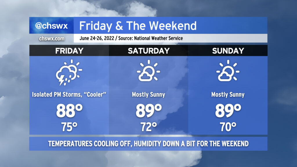
A front will sag southward across the area on Friday, bringing with it some cooler temperatures and a slight chance of afternoon thunderstorms. We’ll lop about 6-8° off today’s observed high of 96° tomorrow as winds turn a little more onshore as the front gets by. Only a few of us will see storms tomorrow, so keep the watering gear on standby as you’ll probably need it for a few more days.
Ridging aloft will continue to build into the area for the weekend, but east to northeast winds at the surface will help keep temperatures and humidity (to an extent) in check. Expect highs in the upper 80s to around 90° each afternoon with dewpoints running in the upper 60s, yielding heat indices in the low 90s. Mostly sunny skies will be the rule with the somewhat drier atmosphere and sinking air keeping updrafts in check. While the air won’t feel quite as nice as last weekend, it’ll still be a good couple beach days. Pack the sunscreen!
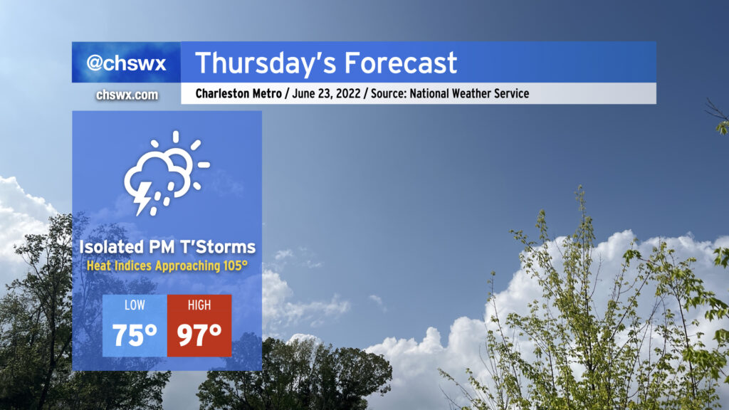
Thursday will be the hottest day this week as air temperatures return to the mid-to-upper 90s across the Lowcountry in the afternoon. Unfortunately, dewpoints will also have recovered back into the 70s, and that could put us close to heat advisory territory for Thursday afternoon as heat indices could approach 105°. There will, however, be a shot at some isolated thunderstorms later in the afternoon into the evening hours as the seabreeze makes its move inland. Lightning and gusty winds will be the primary concern from any thunderstorm that forms, but so far widespread severe weather doesn’t look likely.
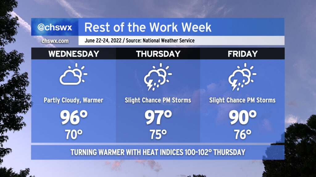
After today came in cooler than expected thanks to some cloud cover (and even a few light showers), the heat should begin to really kick back in on Wednesday as we’ll see much more sunshine than we did today. The atmosphere remains dry and capped, and that will keep afternoon shower and thunderstorm chances at bay for one more day. 70s dewpoints return in earnest for Thursday, and that combined with a 97° air temperature will drive heat indices into the lower 100s in the afternoon. We’ll also start to see the standard slight chance of afternoon thunderstorms return to the forecast Thursday. A weak front will head south across the area late Thursday into Friday, taking the edge off the higher heat for Friday with highs topping out around 90°. We’ll keep a slight chance of seabreeze storms in the forecast to close out the week.
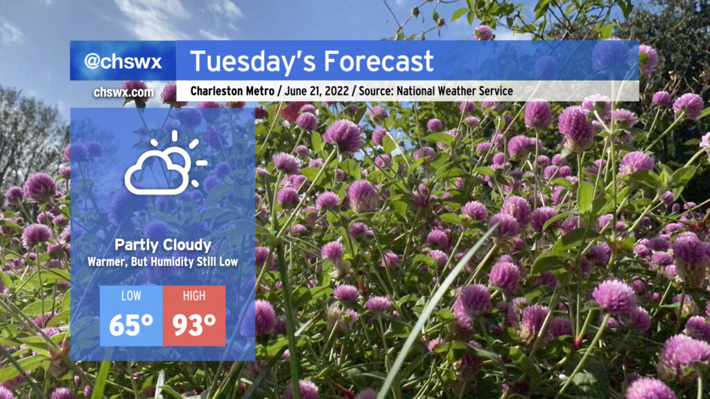
Tuesday will be another warm day with plenty of sunshine and still-tolerable humidity. Highs will continue their warming trend, with low-to-mid 90s possible in the afternoon hours. Dewpoints in the low 60s, though, will yield relative humidity values around 35-40% at the peak of the day. This could make the heat index feel slightly cooler than the air temperature, which is a welcome anomaly for this point in the year. Much like the past few days, the drier air will help suppress afternoon shower and thunderstorm chances.
The warmest day this week looks to be Wednesday, as highs top out in the upper 90s away from the coast (though, thankfully, we’ll still benefit from some drier-than-normal air to keep heat indices somewhat in check). Wednesday could challenge the record high (98° in 2015 and 2011) so we’ll want to keep an eye on that. Dewpoints return to the 70s on Thursday, and heat indices will respond by heading into the low 100s. We’ll also start to see some slight afternoon shower and storm chances creep back into the forecast, too. Temperatures moderate a little on Friday with a little more onshore flow but also a small uptick in shower and thunderstorm chances as well.
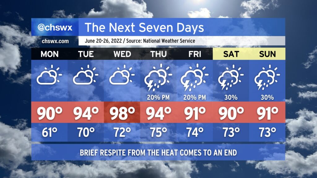
All good things must come to an end, and that includes our brief respite of below-normal temperatures that we’ve seen today. We do get one more crisp (by June standards) morning with lows bottoming out in the low 60s away from the immediate coast Monday morning. This will be followed by highs rising to around 90° in the afternoon. Thankfully, humidity will stay on the lower side to start the week as drier air remains firmly in place. Northwest flow around an anomalously strong ridge of high pressure will act to further dry out the atmosphere during the day, which will also help temperatures out to the mid-90s on Tuesday and the upper 90s on Wednesday thanks to compressional heating from downslope flow. The tempering of humidity will help keep heat indices from getting too far out of whack, but at the end of the day, the mid-to-upper 90s is still pretty hot weather. The lack of moisture will suppress development of afternoon showers and thunderstorms, so we look to stay rain-free through Wednesday.
We’ll start to see changes on Thursday as the aforementioned ridge of high pressure shifts west a bit. This combined with a little bit more troughiness and onshore flow at the surface will help reintroduce some slight shower and thunderstorm chances for Thursday and Friday afternoons. A front encroaching on the area could lead to a little uptick in storm chances for next weekend, but so far it doesn’t look like anything completely out of the ordinary for mid-to-late June.
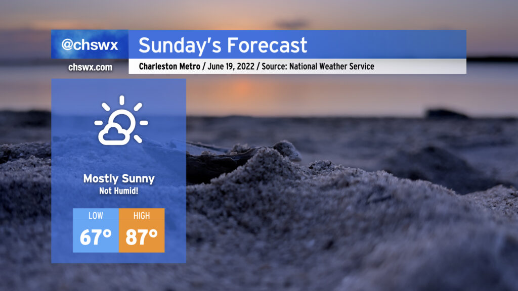
Folks, we’ve been handed a gift: A very not-humid, spring-ish mid-June day for Father’s Day. We start the day with lows in the mid-60s away from the coastline under mostly clear skies. Temperatures will warm into the mid-80s in the afternoon while dewpoints mix out into the 50s — very rare air for this point in the year around here. This will yield relative humidity values below 40%, and as such, a wonderful Father’s Day gift from Mother Nature. We’ll have a few clouds from time to time, so make sure you’re using sunscreen, but other than that, there are no weather concerns. Enjoy!
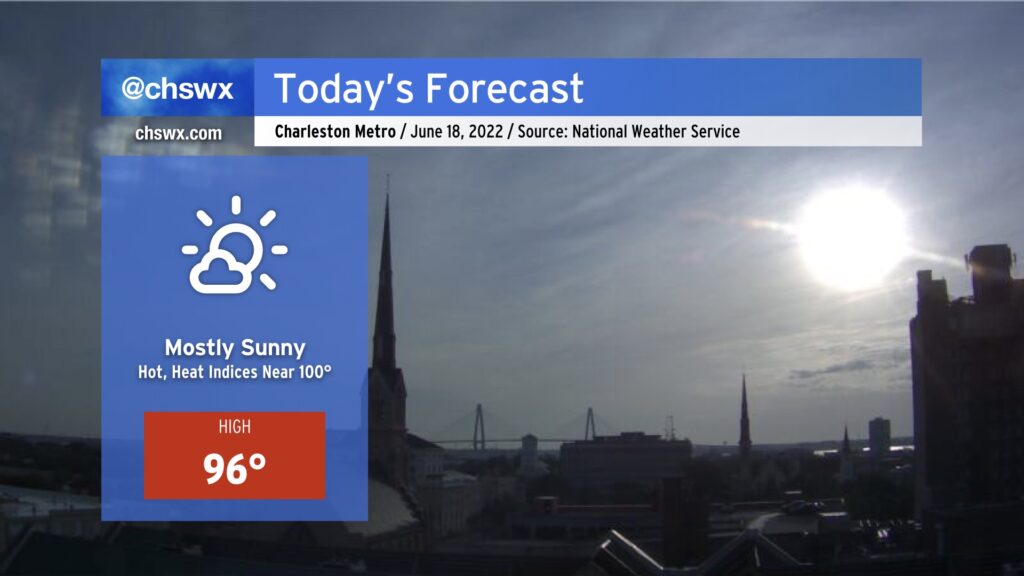
Another hot day lies ahead as air temperatures head back up to the mid-90s thanks to downslope flow from the Appalachians. Said downsloping, though, will help keep dewpoints — and the heat index — from getting too far out of bounds. Heat indices will “only” peak around 100° this afternoon. While still quite hot, we aren’t headed into that more dangerous temperature territory today as a result of the drier air. This will also essentially suppress thunderstorm development; in fact, today marks the beginning of what looks to be a rain-free few days across the area. With just a few clouds expected, definitely deploy the sunscreen as the UV index approaches 11 during the peak of the day.
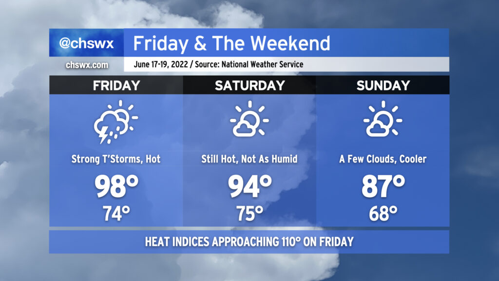
We have another potentially boy-band-hot (98°) day on tap for Friday as temperatures soar ahead of a cold front. Expect heat indices to once again approach 110°, with a heat advisory a near-certainty as a result. Said heat and humidity will translate to plenty of thunderstorm fuel for potential strong to severe thunderstorms in the evening hours ahead of the front. There’s still model disagreement about exactly when and where thunderstorms will fire, but if and when they do, a few will be capable of damaging wind gusts. You’ll want the weather radio nearby tomorrow evening, especially if you are out and about.
The front gets through late Friday into early Saturday, shutting off rain chances and even helping to dehumidify us a touch. Saturday will still be hot, with air temperatures reaching the mid-90s, but dewpoints in the upper 60s as opposed to the mid-70s will keep heat indices generally below 100°. Sunday looks even better — honestly a pretty fantastic day to get outdoors, particularly in mid-June — with a punch of cooler and drier air keeping air temperatures to the mid-80s for much of the area. The respite will be short-lived, though, as temperatures soar once again by the middle of next week, possibly flirting with 100° on Wednesday.
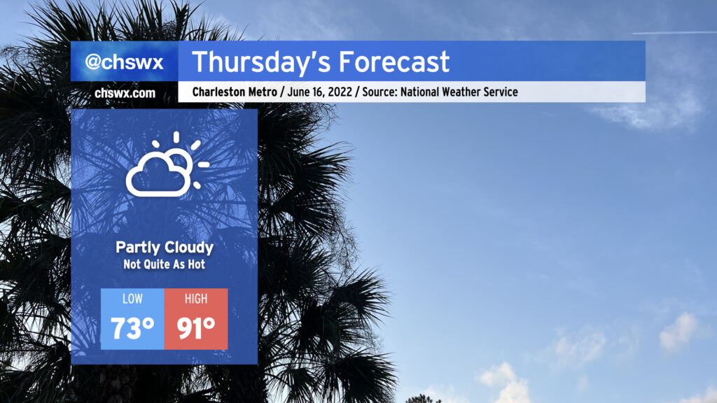
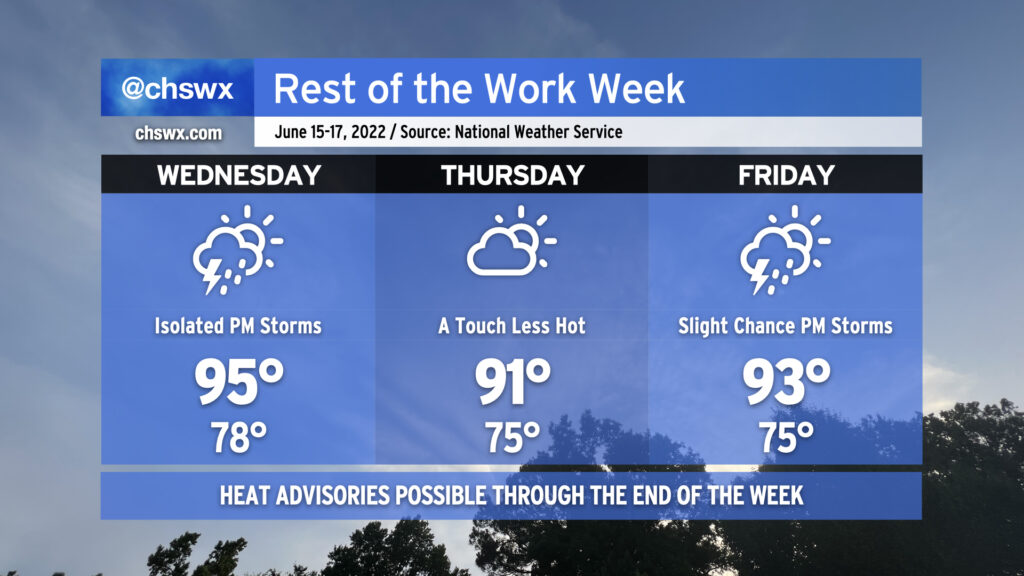
Thursday will run a little cooler — 91° with a heat index of 94° certainly qualifies — as onshore flow behind a backdoor cold front gives us a little break before the heat picks back up on Friday. With the slightly cooler weather comes a somewhat more stable atmosphere, which will keep the risk for afternoon showers and thunderstorms to a bare minimum. All in all, should be a fairly decent day for an outdoor dinner. (Might still be a bit much for eating lunch outside, though.)
The rest of the work week will remain hot — though not to the degree that we observed today, with the first 98° reading at the airport since August of 2019 — with only a slight chance of a thunderstorm as a strong ridge remains firmly in place across the area. Heat indices could once again reach advisory criteria tomorrow with only a slight chance of a thunderstorm to cool things off. So it will go Thursday and Friday, too, though onshore flow behind a backdoor front will keep temperatures a little “cooler” on Thursday, topping out “only” in the low 90s. Bottom line: Stay geared up for hot weather for the foreseeable future. We’ve got a little break coming Sunday, but the heat will then just surge right back as we get into next week. (Such is summer.)
Coastal flooding will continue to be an issue with the evening high tides through Friday. Onshore flow should send tidal departures even higher on Wednesday evening, with moderate flooding expected with the 9:55 PM high tide. Expect scattered to potentially numerous road closures in downtown Charleston tomorrow evening as a result, though thankfully after the commute.