Jared Smith founded @chswx on Twitter in 2008 as an experiment in disseminating weather data through social media. In the ensuing decade-and-a-half, @chswx has provided live coverage of tropical cyclones, tornadoes, severe weather, and even a couple bouts of winter weather to the good people of Charleston, SC.
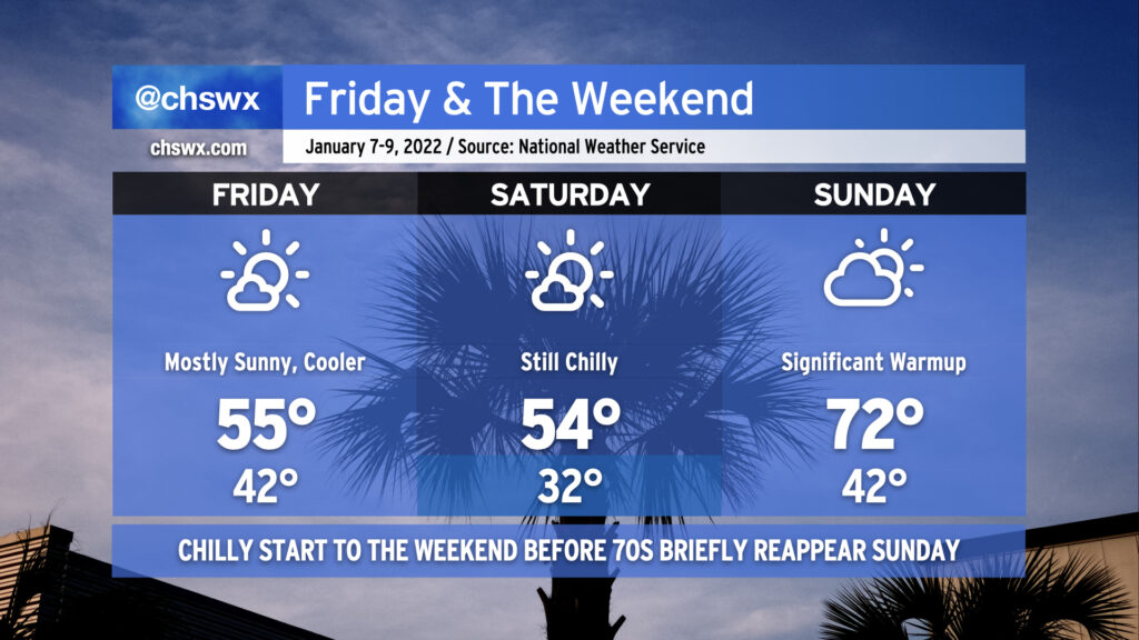
After a couple slightly warmer days, a reinforcing shot of cooler air arrives for Friday into Saturday. Highs will once again top out in the mid-50s both days despite plenty of sunshine. A freeze is even likely for most of us away from the coast on Saturday morning, too. By Sunday, though, high pressure quickly slips offshore and the southerly return flow turns the heat pump back on, sending us into the low 70s in the afternoon ahead of an advancing cold front. There could be some shower chances late Sunday, but the best risk of rain right now appears to be overnight Sunday into Monday morning as the front swings through. All in all, not a bad-looking weekend with a little something for both cool-weather and warm-weather fans.
Additionally, tomorrow should be only the second time this year that we will not have any coastal flooding concerns in Charleston Harbor. Water levels once again peaked just over 7′ this morning, making it 5 of 6 days so far in 2022 with some tidal flooding to contend with. (The one day there was no flooding? Monday, when the windstorm blew the tide out well below predicted levels.)
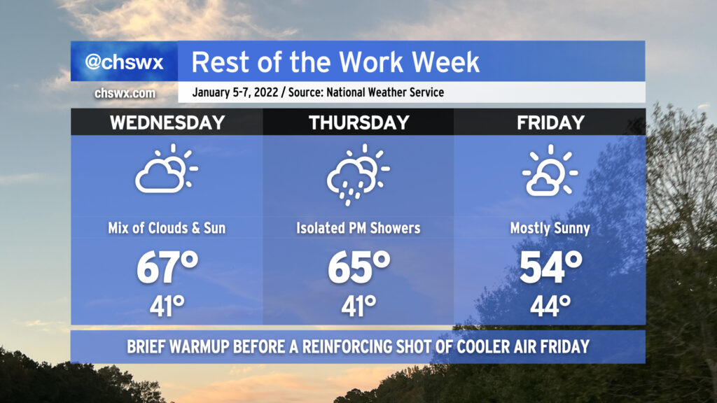
After a couple chilly days post-storm, temperatures will trend back up in a big way for Wednesday as high pressure slips southward, sending winds in a more westerly direction. After just topping out at 54° today, look for highs in the mid-60s on Wednesday with a mix of clouds and sun as a coastal trough lingers nearby. The mid-60s continue into Thursday ahead of a cold front which could bring us a few showers late in the day. By Friday, the front will have cleared and temperatures will once again run in the mid-50s as cooler high pressure builds in from the west.
Expect these cool temperatures to persist into Saturday before warming up big-time on Sunday ahead of a more potent front, which by Monday evening into Tuesday could bring us an even cooler airmass linked to strong high pressure building out of the Plains.
Coastal flooding will once again be an issue with Wednesday morning’s high tide, predicted to peak around 7.5′ around the 10am hour. This will once again cause minor to moderate coastal flooding in parts of downtown Charleston and could close a few roads. Be ready to use alternate routes in case you encounter a flooded road.
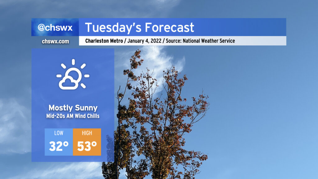
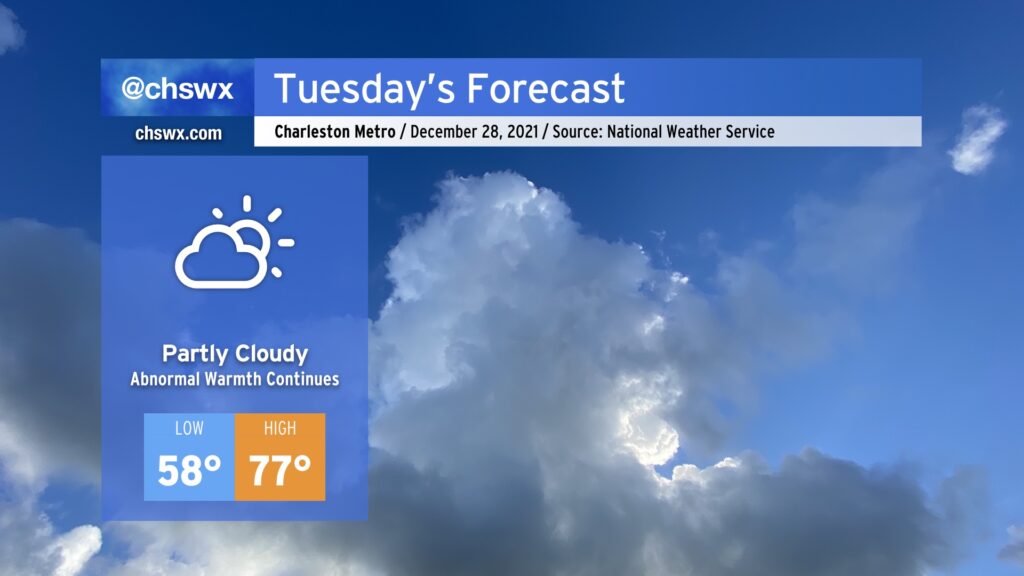
Tuesday’s weather, in a word: Quieter. It will also be much less windy than today was, though that’s not a hard bar to reach either. We’ll start the day around freezing in the metro area, with upper 20s further inland, while places near the coast will stay above freezing. Mostly sunny skies will be the rule, with cloud cover increasing a bit as the day goes on.
The main weather hazard for Tuesday will be the potential for moderate coastal flooding with the morning high tide. The forecast is for water levels to reach 7.8′ around 9am. This will certainly be high enough to close several roads in downtown Charleston, including the Highway 61 off-ramp from the Ashley River southbound bridge as well as parts of Lockwood Drive. Be ready to use alternate routes if downtown is in your commuting plans.
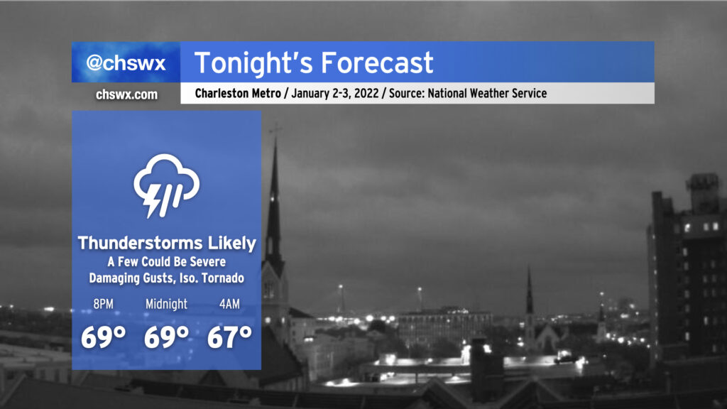
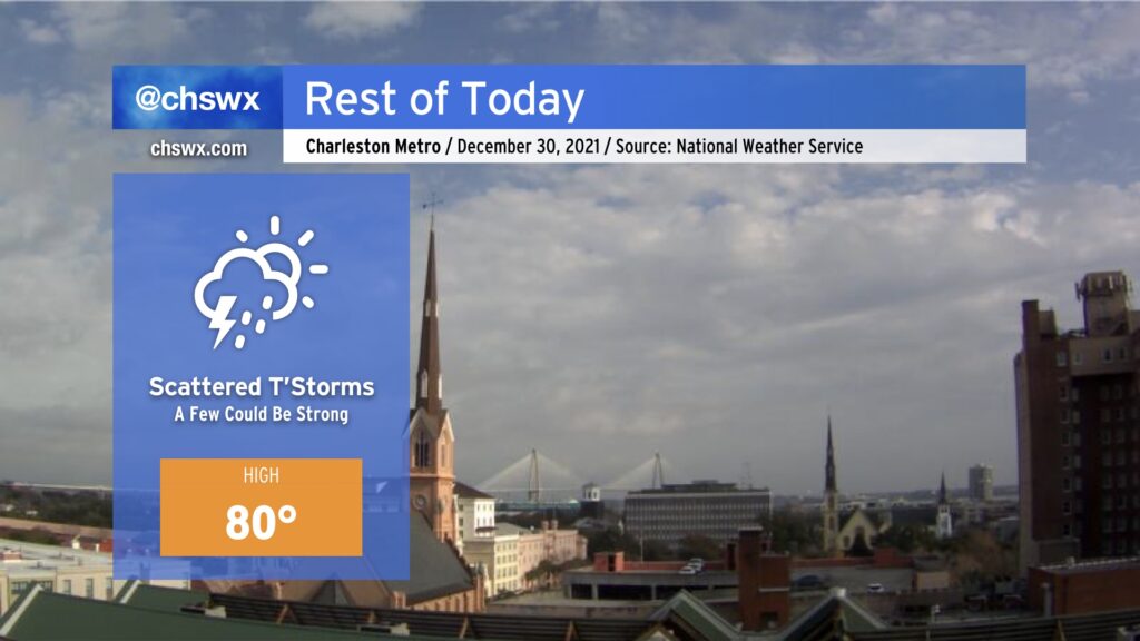
Tonight’s forecast is rather tricky. We’ve had a good bit of rain across much of the Tri-County today that has helped to knock temperatures back into the 60s in most spots, but it is still conceivable that a few severe thunderstorms may develop overnight.
If you’ve not been a fan of this uncharacteristically warm weather that’s permeated the better part of the last week and a half around here, some good news: changes are coming in a hurry. However, that’s going to mean another round of storms with the potential for a couple of those to be on the strong side.
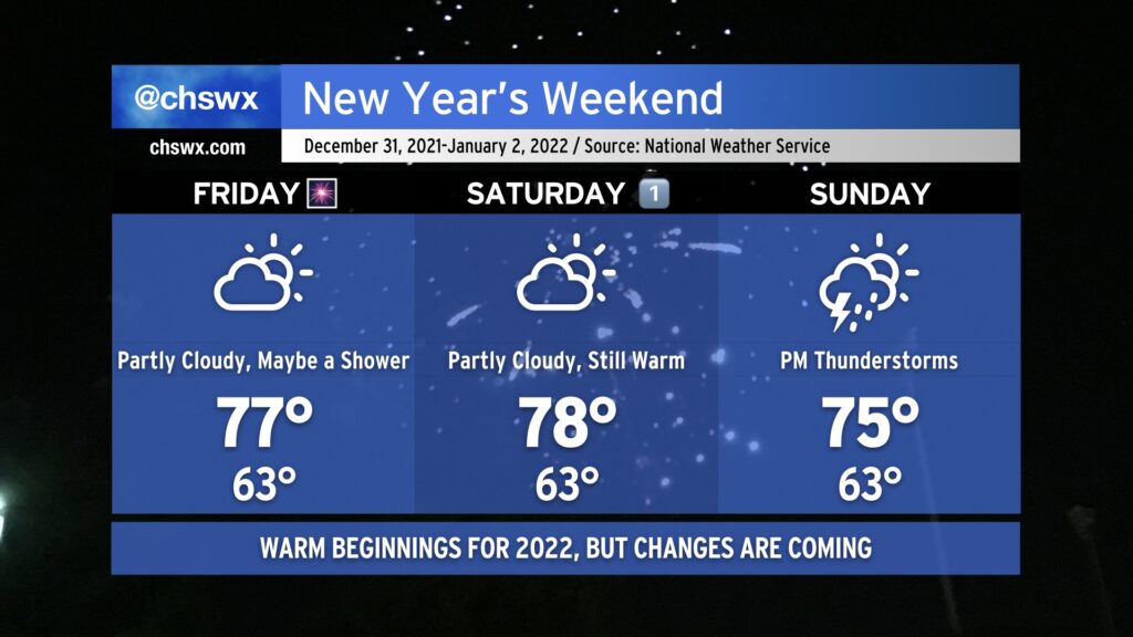
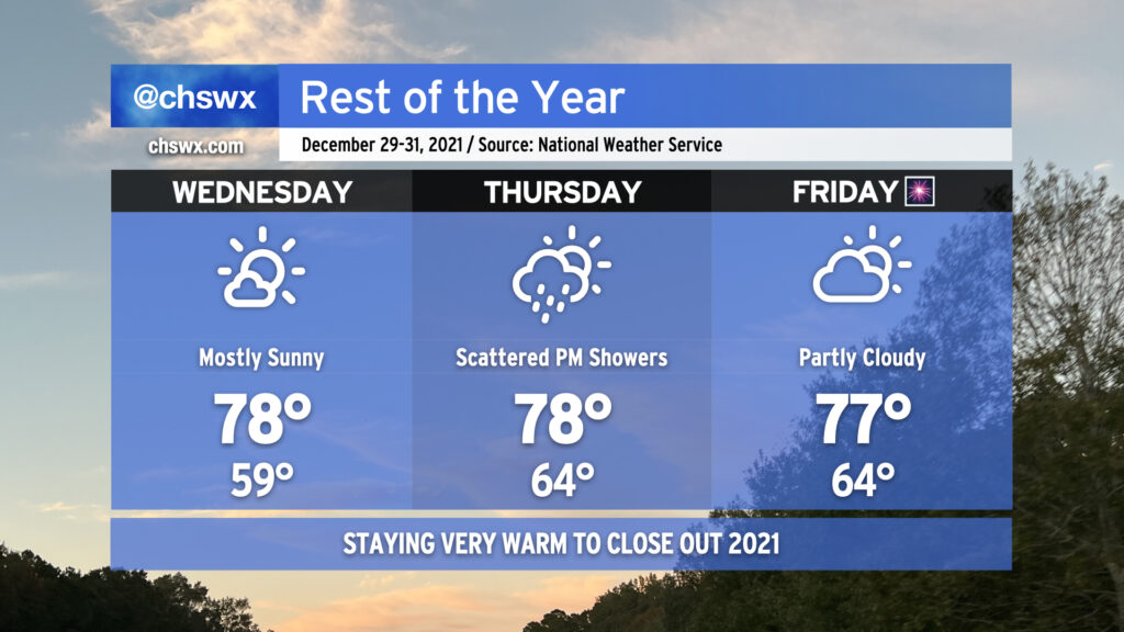
After some much-needed rain (and some lesser-needed hail) on Thursday, we head into New Year’s Eve with continued warm temperatures as a frontal boundary, which has caused some complications for the weather in the southeastern US this week, remains stalled well to our north. A shower or two can’t totally be ruled out Friday, but much of us should remain dry to close out 2021, and fireworks displays should be unimpeded as a result. Temperatures will once again head well into the 70s in the afternoon, and could challenge the record high of 78° last set in 1996.
New Year’s Day will remain quite warm with a mix of sun and clouds. Highs should stay just shy of the record of 80° we set on January 1, 2021, but they will certainly get close as we remain within the warm sector. Saturday should remain rain-free for the Lowcountry with no appreciable disturbances to speak of to instigate shower activity in our neck of the woods.
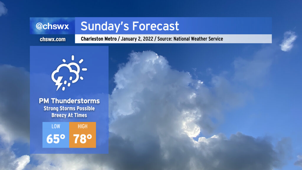
The pattern will finally begin to change on Sunday as a potent upper-level system dislodges the stalled front and finally pushes it eastward. Expect showers and even a few thunderstorms ahead of the cold front Sunday afternoon and evening. A few storms could be on the strong side given good upper-level support and probably just enough instability. Highs top out in the mid-70s owing to cloud cover and rain chances. There’s still questions on when the front ultimately gets through, but all indications are that the first Monday of 2022 will be significantly cooler than we’ve experienced in the past couple weeks! Hang in there, cool weather fans — almost there.
Scattered showers and thunderstorms will increase in coverage later this afternoon and early evening as the air becomes warmer and more unstable. Highs should reach the low 80s, and may challenge the record of 82° set in 2015.
Given plentiful wind shear and the unusual amount of instability available in late December, there will be a risk for a few storms to turn strong to severe, particularly away from the immediate coast. Damaging wind gusts will be the primary concern, but a storm or two could rotate and produce a brief tornado as well. A widespread severe weather outbreak is not likely, but you’ll want to stay close to trusted and reliable sources of weather information throughout the afternoon and evening in case watches and warnings are required.
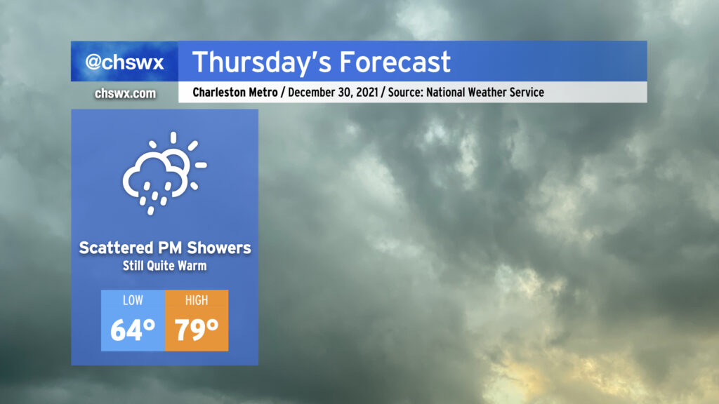
Our blowtorchy end to 2021 continues on Thursday despite increased cloud cover and even the specter of a few showers moving into the area. Highs could once again get close to the 80° mark in the afternoon. Thursday’s record high of 82° will probably stay safe, but it’ll be close.
Some showers look to move into the area in the mid-afternoon hours and persist through early evening as a front gets close to the area (but doesn’t get through). There’s a chance that we could even see some rumbles of thunder and brief periods of heavy rainfall if the convection-allowing models are sniffing things out correctly. The risk for severe weather appears extremely low, but we’ll need to keep an eye on how things evolve to our northwest. All that being said, keep rain gear handy if you’ve got outdoor plans tomorrow afternoon, but forget about any winter clothing until Monday.
2021 is going to close out on a very warm note for the Lowcountry. At the surface, subtropical high pressure will hold firm while the flow aloft continues in a zonal pattern, resulting in an inability to get any fronts through here until the first of the year.
We’ll have at least one or two more opportunities to break record highs before 2021 is all said and done. Wednesday should feature a little less cloud cover, allowing temperatures to challenge the record high of 79° set in 2015. Despite the possibility of some scattered showers Thursday as an upper disturbance ripples by, temperatures should still warm into the upper 70s. (This will fall short of the record of 82°, though, set in 2015.) Partly to mostly cloudy skies return Friday with highs in the upper 70s once again getting close to the record of 78° set in 1996. Indeed, it would be a fitting end to a year that started with a record high — 80° on New Year’s Day.
Atlantic high pressure will keep its hold across the area, and as a result, we’ll stay quite warm continuing into Tuesday. Cloud cover will act as a bit of a governor on just how warm we get, but we should expect another day of upper 70s across much of the area. It won’t be record heat, though: the record high for Tuesday is 82°, last set in 2015, which appears safe (unlike today’s record high of 78°, which we tied).
Cooler weather is still several days away, but it does look like we’ll begin to see things cool off as we kick off the first work week of 2022. Stay tuned…