Jared Smith founded @chswx on Twitter in 2008 as an experiment in disseminating weather data through social media. In the ensuing decade-and-a-half, @chswx has provided live coverage of tropical cyclones, tornadoes, severe weather, and even a couple bouts of winter weather to the good people of Charleston, SC.
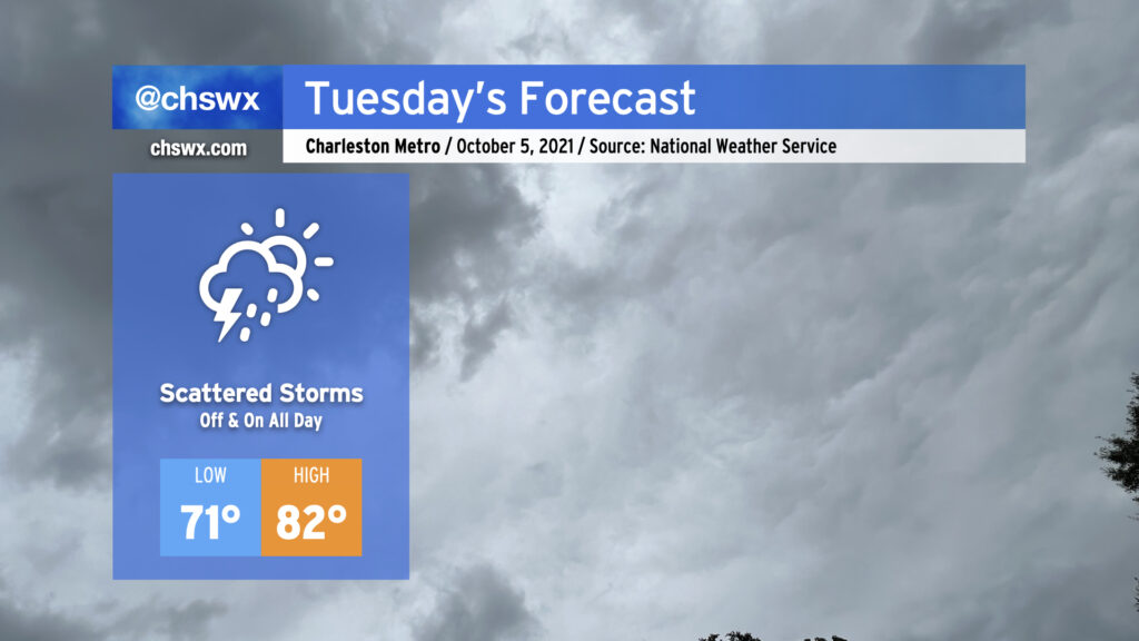
Scattered storms will enter the picture in earnest for Tuesday, perhaps as early as daybreak, as surface troughing combined with an upper low will provide the necessary ingredients for periods of rain tomorrow and for the next several days. Rainfall amounts should generally be light, but a few downpours within stronger storms cannot be ruled out. Temperatures will reflect the rather soggy atmosphere in place; lows won’t crack 70° in most spots and could bottom out in the mid-to-upper 70s at downtown, while highs won’t top out too far above 80° given expected cloud cover and rainfall in the area.
No severe weather is expected, but we will want to watch for the potential for some salt water flooding around the 7:52 PM high tide as astronomical effects combine with onshore flow to raise water levels in the harbor. The 7:35 AM high tide, which is forecast to fall short of coastal flood stage, will still bear a little watching in case a downpour develops near Downtown around that time, but the flood probability in the morning is generally low.
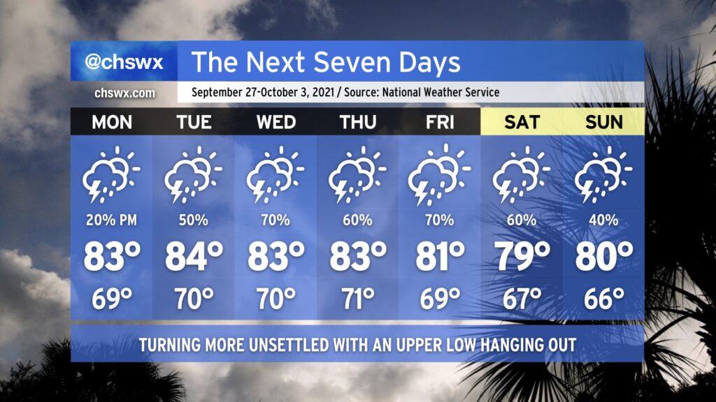
After a coastal trough made this weekend quite a bit wetter than first anticipated, we’ll see rain chances steadily head up throughout the week as an upper low approaches the area and stalls out. Rain chances continue into the weekend as we watch a surface trough approach the area from the Bahamas.
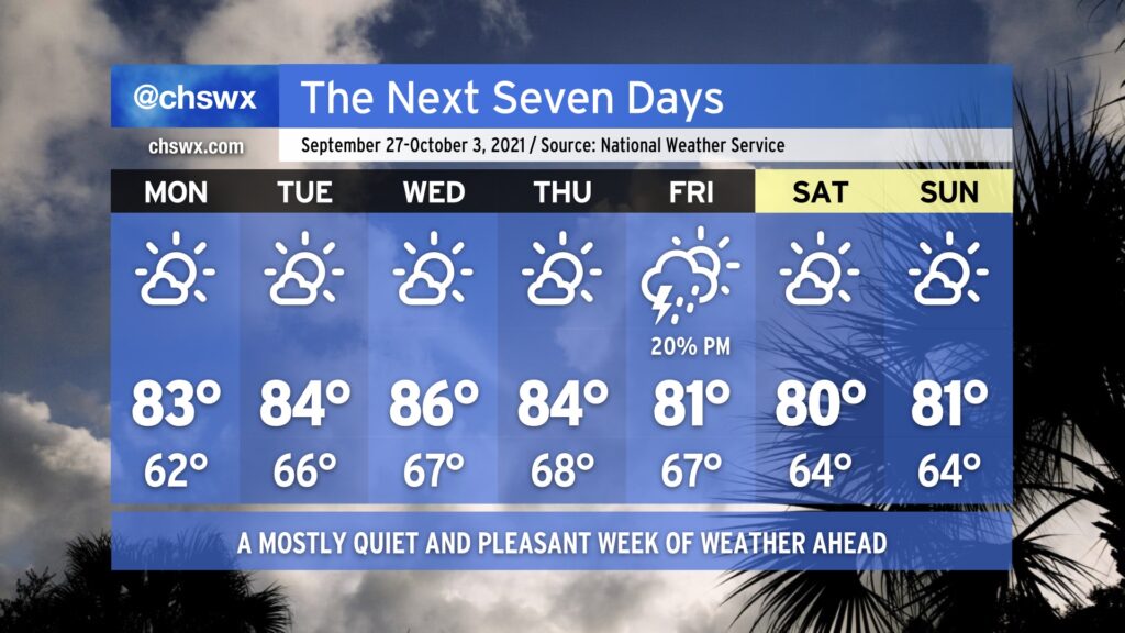
We’ll likely see a wide scattering of showers on Monday, but between high pressure’s last gasp across the area and the better forcing from the upper low staying just to the west, we’ll likely mark Monday as the driest day of the week. Said upper low gets closer and stalls out Tuesday and Wednesday, helping to enhance lift and moisture transport across the area, which in turn improves rain chances. Moisture hangs around into the weekend, keeping rain chances in place as troughing approaches from the Bahamas. NHC is watching this for a slight chance of tropical development, but high wind shear should preclude any development. Shower chances look to persist into the weekend as a coastal trough redevelops and persists.
Temperatures will remain right around normal for early October, but we will remain on the humid side with lows bottoming out around 70° inland and in the mid-70s near the coast.
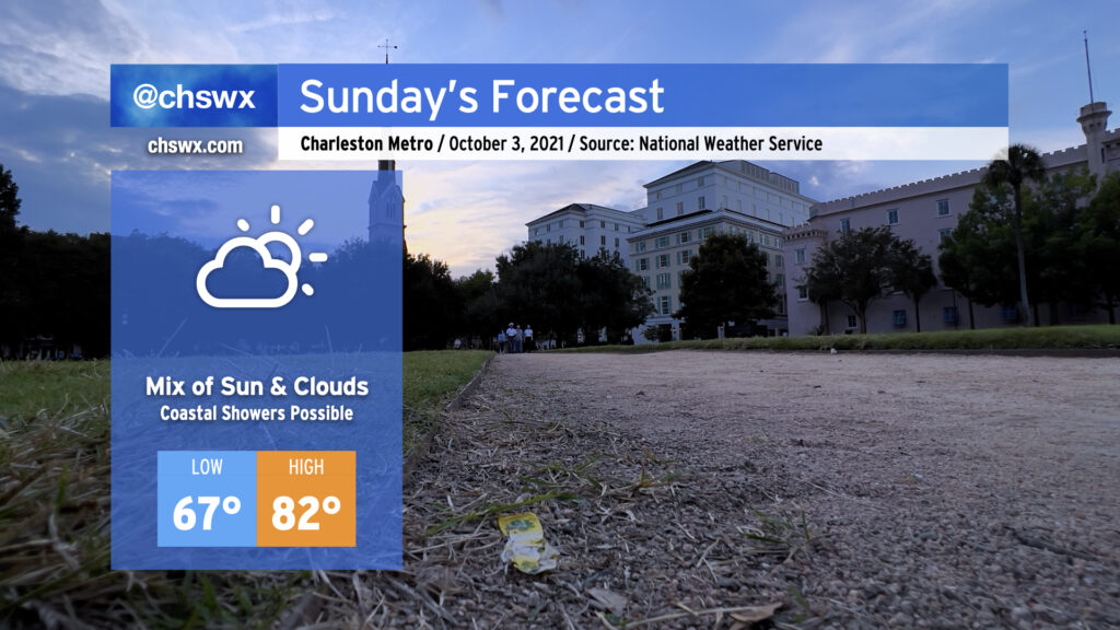
High pressure moving into the Atlantic has pushed a coastal trough closer to the coast. Its enhanced moisture convergence has kept us a little cloudier than we might like today, with even some showers coming ashore at times throughout the day. A mix of sun and clouds looks to continue into Sunday, with a slight chance of some showers once again brushing the coast. The vast majority of us look to stay rain-free, and northeasterly winds combined with a little bit more cloud cover should keep temperatures down in the low 80s once again.
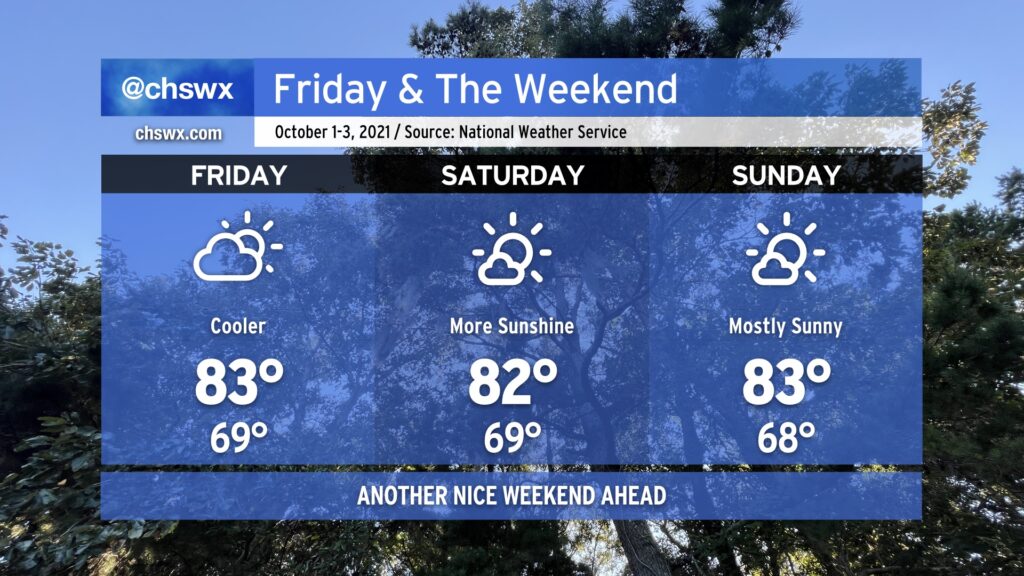
All in all, expect another nice weekend across the Lowcountry as a little cooler air works down into the area over the next few days. Temperatures will generally top out in the low to mid-80s across the area, with lows in the upper 60s inland and the low 70s near the coast. Aside from a small risk for a shower or storm tonight, particularly in the upper reaches of the Tri-County, our next appreciable rain chance doesn’t arrive until next Tuesday.
The tropics remain busy, but Hurricane Sam and recently-minted Tropical Storm Victor are staying out to sea and are not threats to the Lowcountry. We may see some enhanced rip current risk and wave action from Sam over the next few days, so be aware of this risk if the beach is in your plans. Otherwise, no concerns. Fingers crossed it stays this way — we’ve got two months to go in what has been a very busy 2021 hurricane season.
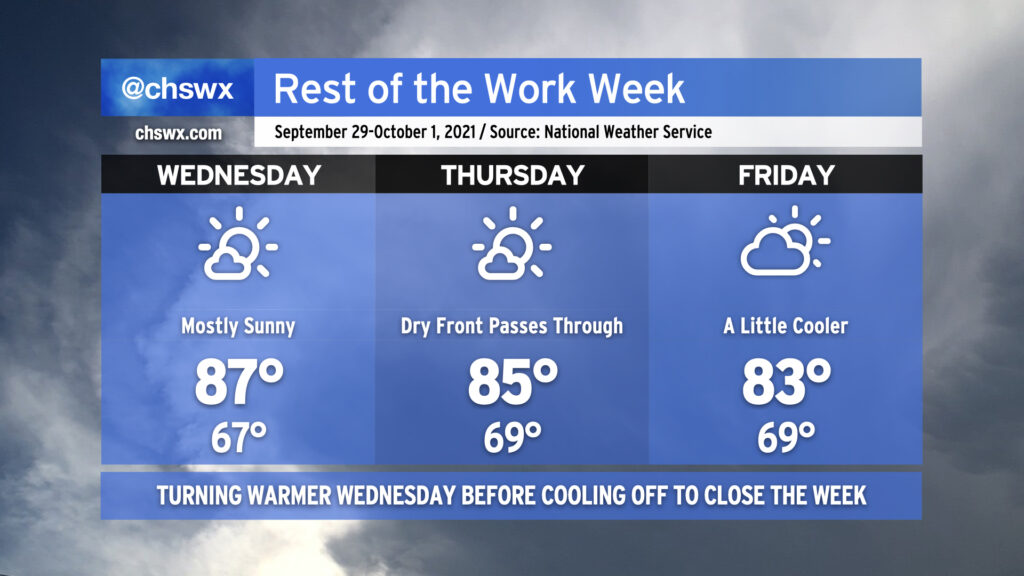
The temperature curve is very much respecting Wednesday as Hump Day with highs topping out in the upper 80s, as high as they’ll get this week before gradually coming down for Thursday and Friday as a dry cold front sinks south across the area. Mornings will remain a little on the warmer side, with upper 60s to low 70s common across the metro area, warmest near the beaches and coolest inland.
We’ll remain rain-free despite a front coming through Thursday as moisture remains in limited supply. In fact, the first appreciable rain chance we’ve seen in more than a week will probably arrive on Monday or Tuesday, and even then right now the chances are pretty slim.
The tropics remain busy as Hurricane Sam continues to churn in the Atlantic. There are also two areas of interest in the far eastern Atlantic that are very likely to exhaust the primary name list for the second consecutive season, but neither those areas nor Sam are a threat to the Carolinas as we move into October.
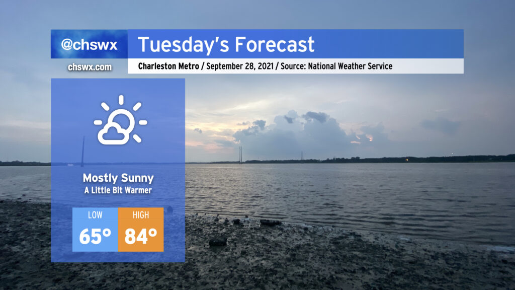
We’ll continue with dry weather on Tuesday, though dewpoints will continue to creep up and put a little more humidity into the picture. Temperatures will continue to run in the mid-80s tomorrow and for the next couple days before a weak front swings through the area later this week, knocking highs back down to around 80°. All in all, we’re good on the weather front — now we just need the seismic activity to chill.
The 3.3 magnitude earthquake many of you felt earlier this evening was centered just north of West Ashley. This was the first 3+ magnitude earthquake in the Lowcountry since 2014, and the strongest since a 3.6 quake near Sangaree in 2008. There were two other earthquakes beforehand: a 2.8 near Summerville at 12:49 PM followed by a 2.0 in the same vicinity just before 1PM. It’s impossible to know if there will be additional shocks, but these small quakes are a fact of life in the Lowcountry and happen somewhat more frequently than you might think; it’s rare to have one that is very well-felt, though. Something tells me Mother Nature just wanted something for the weather/earth science people to do given the quiet conditions. 🙂
We will close out September with a weather winning streak intact. Temperatures will gradually moderate into the mid-to-upper 80s as we get into midweek with mostly sunny skies each day. We could see a front swing through later in the week; while it will be moisture-starved, it might be able to squeeze out a storm or two. Then, back into the low 80s for the weekend, with mostly sunny skies prevailing. Not a bad way to close out the month and head into the fourth quarter of 2021 (already!).
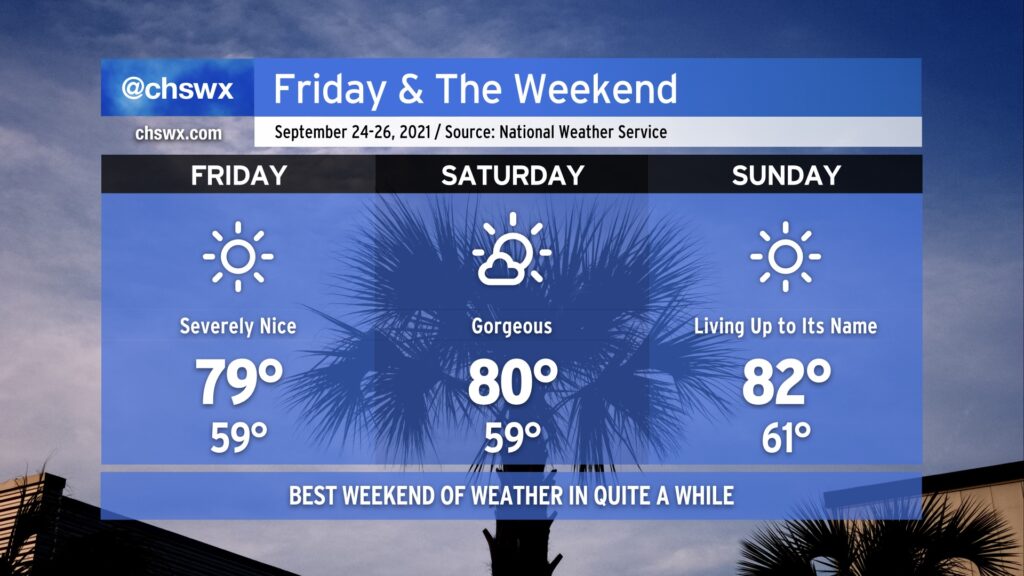
We’ve earned it: A beautiful weekend is imminent as the first really solid shot of fall weather, ushered in by a cold front that swung through late last night, continues for the next several days. Lows look to bottom out in the upper 50s for the first time since June 1, and we likely will top out right around 80° under full sunshine. Similar conditions, with perhaps a few more clouds, continue into Saturday. Sunday will certainly live up to its name, with temperatures beginning to moderate ever so slightly back to the low 80s with continued low humidity.
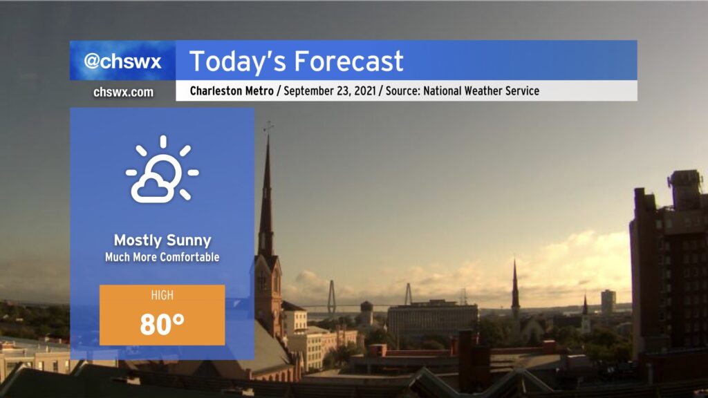
Beautiful day ahead in the wake of a cold front which swept through last night. Cooler, drier air will filter in throughout the day, and highs should only top out around 80° as a result with low humidity and copious amounts of sunshine. Pretty fantastic.
This will begin a bit of a weather winning streak for us, with tranquil and comfortable conditions continuing well into next week. Enjoy!
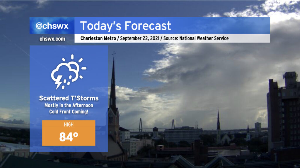
We have one more warm and muggy day ahead with a scattering of showers and thunderstorms ahead of a cold front; once this front gets through tonight and into tomorrow morning, conditions will take a turn for the awesome to close out the work week and head into the weekend. For today, though, keep rain gear handy. It won’t rain all day but if it does, it could be briefly heavy. (At least we’re getting some sun this morning!)
Astronomical fall begins this afternoon at 3:21 PM — it will certainly feel a lot like this after today. Looking forward to it!