Jared Smith founded @chswx on Twitter in 2008 as an experiment in disseminating weather data through social media. In the ensuing decade-and-a-half, @chswx has provided live coverage of tropical cyclones, tornadoes, severe weather, and even a couple bouts of winter weather to the good people of Charleston, SC.
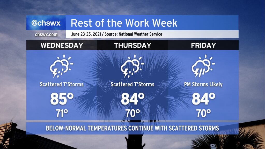
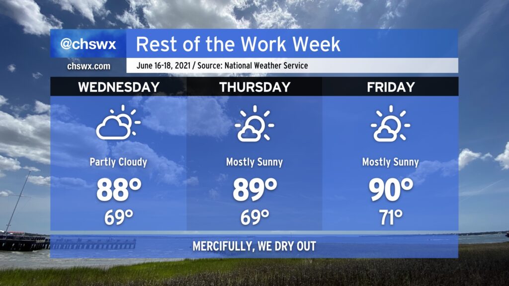
A cold front will pass through the area and stall out to the southeast as high pressure wedges down a little bit from the north. This will generate a bit of onshore flow, keeping temperatures in the mid-80s through the end of the work week. This will also combine with enhanced astronomical tides thanks to Thursday’s full moon to cause some minor to moderate coastal flooding each evening through at least Friday.
Scattered showers and thunderstorms will be possible each day through Friday, with the best chances coming along with the inland-moving seabreeze especially Wednesday and Thursday afternoon. By Friday, we’ll see an increased chance of thunderstorms as high pressure to the northeast gives way, allowing a trough of low pressure offshore to migrate inland and provide a sharper focus for precipitation to form.
With such saturated ground from a pretty rainy June thus far, we’ll want to watch any areas of heavy rain that develop for an isolated flooding threat. This doubly goes for times of the evening high tides due to the aforementioned king tides. With that in mind, the good news is that it won’t rain all day, every day, and not everyone will see rain every day, either.
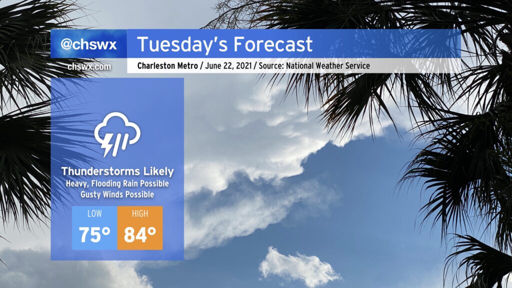
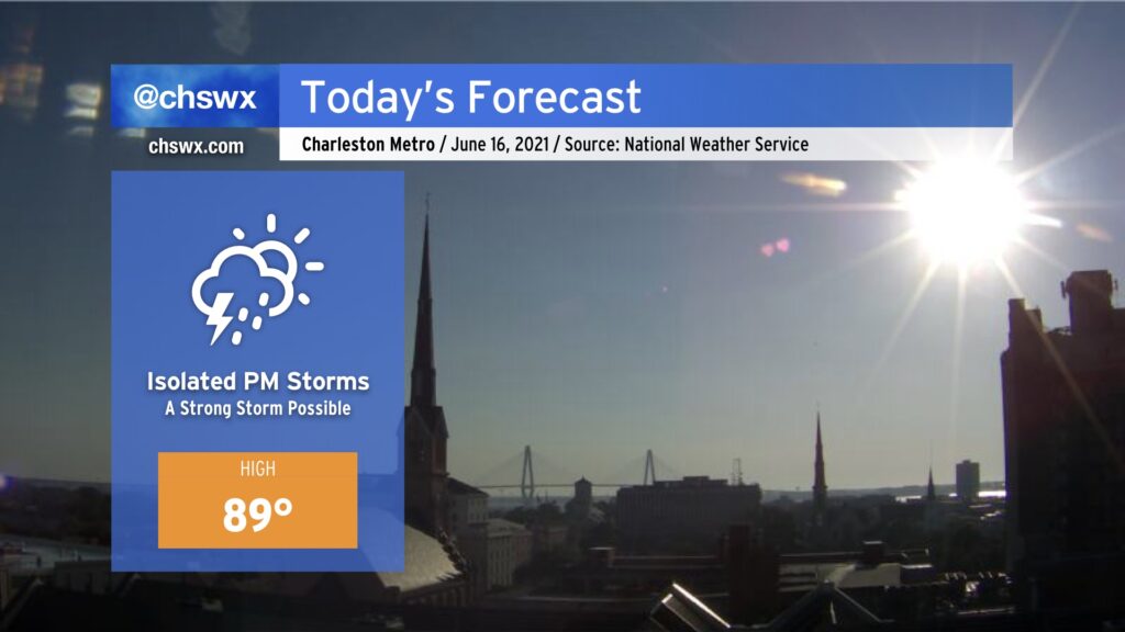
Most of us saw a dry day today, giving us a respite from the heavy downpours that have characterized June thus far. A cold front approaching from the west is going to put a swift end to this respite, though, as it runs into an atmosphere still plenty juiced up with tropical moisture and ready to wring out some more rainfall. Shower and thunderstorm coverage could begin to ramp up as early as tomorrow morning (and some guidance is fairly persistent in it firing up as soon as midnight), with the greatest risk of showers and storms in the afternoon and evening hours. Storms could produce torrential downpours which may produce isolated flooding episodes. Overall, 1-2” of rain will be possible across the area with locally higher amounts.
Additionally, there is the potential for wind damage to occur in some of the stronger thunderstorms, especially where outflow boundary collisions occur. Be alert for possible warnings in the afternoon.
The prevalence of showers and thunderstorms will act to keep high temperatures a few degrees below normal, generally running in the mid-80s. Heat indices will still climb into the 90s, though, thanks to the ever-present humidity.
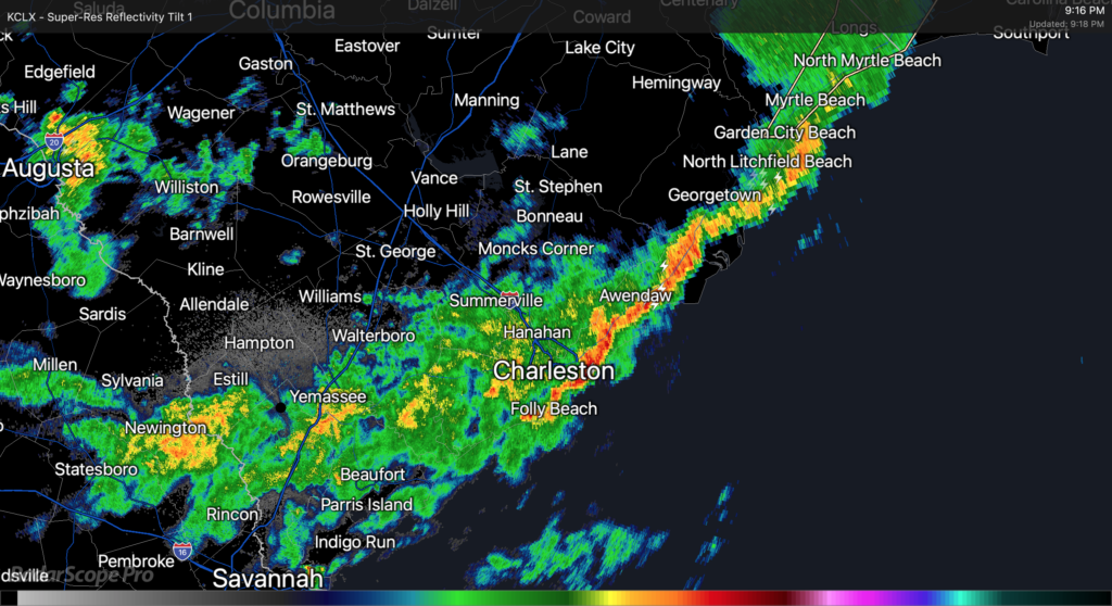
Heavy rain moves through the Charleston Metro Area.
As of about 9PM, Claudette’s center was moving eastward across northern parts of South Carolina. The exact center fix is a little murky, but radar suggests that as of this writing it is roughly riding the SC/NC border around Chesterfield County, SC. The leading edge of Claudette’s primary rain band has cleared downtown Charleston and is headed offshore, with light to moderate rain behind it. This rain band appears to have cleared downtown with relatively little fanfare, but winds have been gusting quite a bit, with a recent gust to 62 MPH recorded at the Isle of Palms WeatherFlow station.
Light to moderate rains look to continue for the next few hours as the primary rain band swings through the area. It appears that there could be additional showers and thunderstorms behind it; these are moving southeastward out of Augusta and could swing around into the Tri-County before it’s all said and done. A Flash Flood Watch continues across the Charleston Metro Area effective until 8am Monday, though this may yet be canceled early once this band lifts out.
The risk for severe weather (particularly the tornado threat) has ended across our area at this point. With the center directly to the north, surface winds coming out of the west lowering shear, and instability having been sapped by the rain band, the environment is not really conducive to tornado formation anymore. We caught a break with this today, especially considering the ample sunshine we saw for a good bit of the day to aid destabilization. Still, straight-line gusts of 40-50 MPH across saturated grounds could still be sufficient for downed trees and power lines, so keep flashlights nearby in case of power outages.
We continue to watch Tropical Depression Claudette’s circulation move through northern Georgia into the Upstate and Midlands of South Carolina this afternoon. NHC’s last fix at 2PM had it roughly around Athens, GA, heading east at 17 MPH. So far, a few spots have seen some brief rainfall, but we have been largely within a dry slot surrounding the inner bands of the circulation. Indeed, it appears that moisture inflow may have been disrupted in part due to vigorous thunderstorms along the Gulf Coast — a common occurrence for choking off more widespread rainfall in our neck of the woods. However, we continue to watch a decent rain band stretching from roughly Mt. Vernon, GA up toward Augusta. This band is steadily making eastward progress, and satellite data suggests it could be becoming a little more vigorous as it moves eastward into a more unstable atmosphere.
A blend of timing tools and model guidance puts this rain band in the Charleston Tri-County area roughly in the 4-6 PM timeframe. It will undoubtedly bring the greatest risk for very heavy rainfall, with models suggesting 1-2″ of rain will be common. 3″+ cannot be ruled out in some spots, either, and wherever this heaviest rain falls could be in line for flooding issues.
High tide is at 4:55 PM. Right now, it appears that the heaviest rain will arrive about an hour or two afterward, but trends will need close monitoring. I would still be prepared for flooding this evening in downtown Charleston.
We’ve had gusty winds in the area thanks to a strong low-level jet — a gust to 32 MPH was recently recorded at Charleston International Airport. Guidance suggests the core of the low-level jet looks to move atop the SC coastline around the time the rain band is moving in, so that could increase the risk for a damaging wind gust or two. This strengthening low-level jet will also assist in creating favorable conditions for a tornado or two, so we’ll want to monitor these trends as we go throughout the day.
Stay weather aware — more updates here and on Twitter as needed.
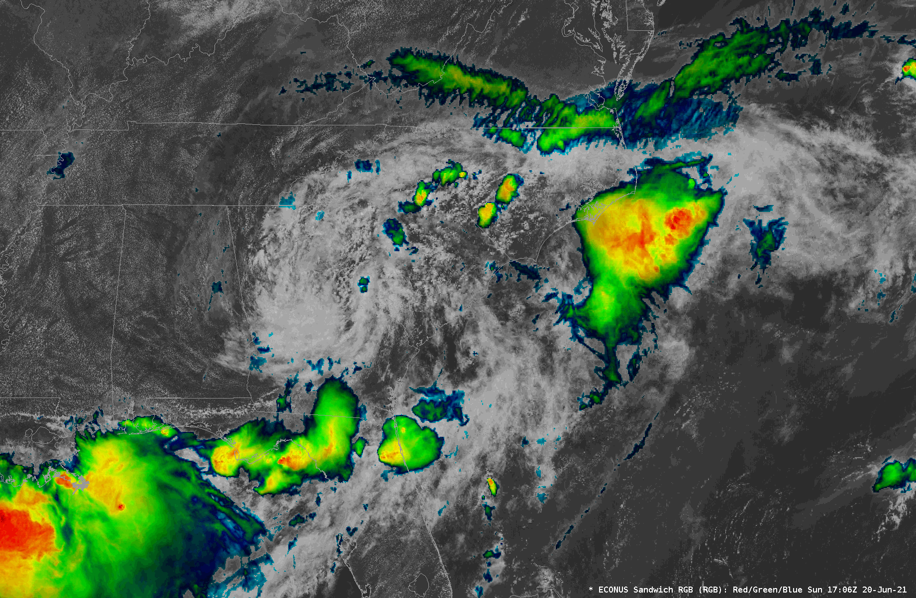
Visible/IR composite of Tropical Depression Claudette as of ~8:30am.
We will be watching the weather closely today as showers and thunderstorms develop and move across the Tri-County area on the southern flank of Tropical Depression Claudette. Heavy rain, damaging wind gusts, and even a tornado or two are all on the table. A Flash Flood Watch is in effect until 8am Monday, and it is conceivable that a tornado watch will be needed later today.
Tropical Depression Claudette, which is moving through western Alabama this evening, will be taking a bit more of an easterly turn around the subtropical ridge, heading through northern Georgia and SC during the day on Sunday. This will, in turn, bring along another plume of tropical moisture into the area, setting up another round of heavy and perhaps flooding rain in spots, along with the risk for strong to severe thunderstorms with damaging wind gusts and maybe a tornado or two.
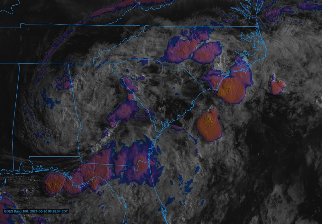
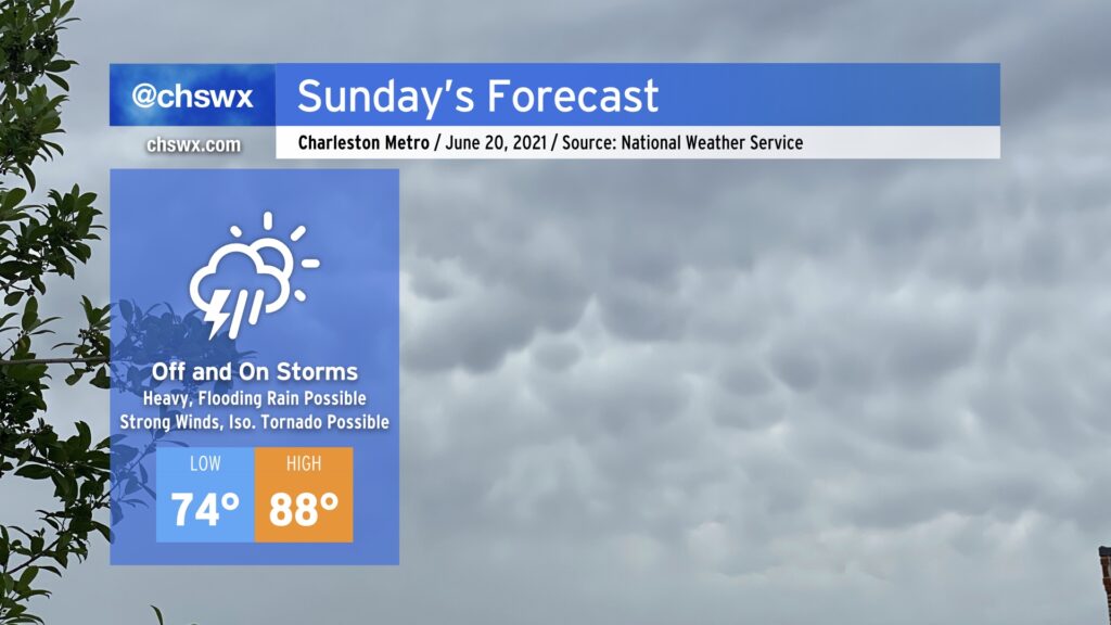
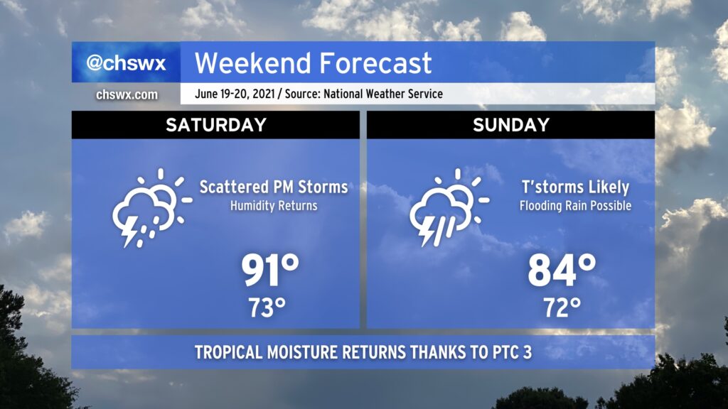
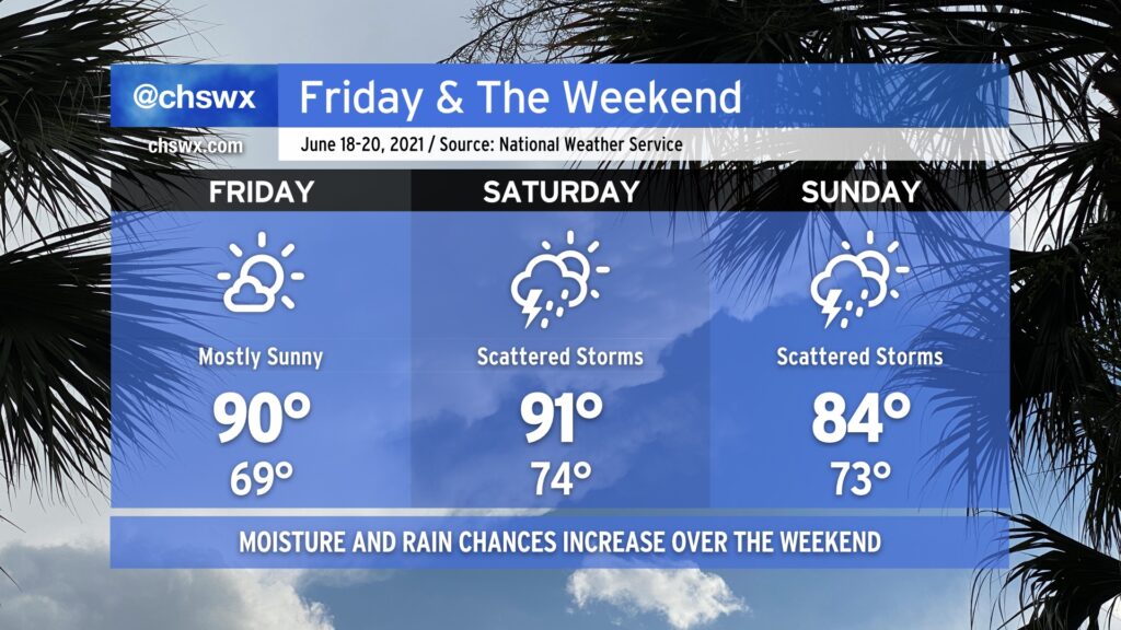
It’s been a great couple days of weather in the Lowcountry, but the remnants of Potential Tropical Cyclone Three look to bring unsettled weather back beginning Saturday afternoon.
After what ended up being a stellar Thursday for mid-June, we’ll get another warm but less humid day for Friday. Temperatures will start in the upper 60s and will top out around 90° in the afternoon. Dewpoints will run in the upper 60s to around 70°, yielding heat indices a couple ticks above the air temperature, but nothing we can’t handle.
As we get into the weekend, we will start to see tropical moisture increase across the area ahead of what is currently Potential Tropical Cyclone 3. There are some timing differences in the models which will have influences on the forecast, but for now, Saturday could feature a couple showers and storms in the afternoon and evening hours after a high of 91° that will feel closer to 97-98°. As we get into Sunday, moisture continues to increase, and the remnants of the tropical low move roughly along the NC-SC border. This will continue to kick up showers and storms into Sunday. Expect periods of heavy rain at times. The big question, though, remains timing, which has run a little later in recent guidance. Thus, I wouldn’t start canceling too many plans just yet — just keep an eye on forecast updates as we get into the weekend.
While the cold front that triggered last night’s deluge has slipped south of the area, it has stalled out nearby. With a little bit of help from some upper-level dynamics, we should see some isolated thunderstorms in the metro area this afternoon. A damaging wind or large hail episode is possible for a few of you, so stay alert across the area this afternoon. With that in mind, the severe threat certainly looks more isolated than we saw yesterday.
Highs top out near 90°; with a little less humidity behind the front, it won’t feel quite as swampy outside.
After today, we look to stay rain-free through Saturday with warm temperatures and low humidity by June standards.
After another night of heavy rain and flooding (with some hail and wind damage mixed in), we thankfully get a few days to dry out as drier high pressure builds south across the area overnight Tuesday into Wednesday. Temperatures will run a degree or two either side of normal for the rest of the work week. Humidity will be rather low for this time of year, and so heat indices will not run too much warmer than the air temperature. Still, “normal” for mid-June means upper 80s to low 90s, so it won’t exactly be cool. But any time we can get a drier heat for a few days during a Charleston summer, we will take it.
More importantly, we will stay rain-free for several days. It’s hard to believe that we were talking about a developing drought just two weeks ago, but here we are after a couple extraordinarily soggy days being extremely pleased to see the rain take a quick break. We look to stay dry through Saturday before tropical moisture once again infiltrates the area beginning Sunday.