Jared Smith founded @chswx on Twitter in 2008 as an experiment in disseminating weather data through social media. In the ensuing decade-and-a-half, @chswx has provided live coverage of tropical cyclones, tornadoes, severe weather, and even a couple bouts of winter weather to the good people of Charleston, SC.
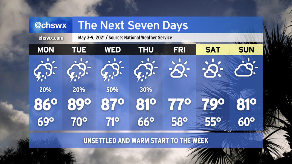
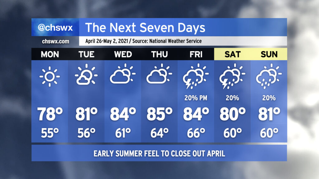
Get ready for a very summer-like start to your week. High pressure slipping into the Atlantic with a little ridging aloft will keep us warm — dare I say it, hot — and humid for the first part of the week. Showers and thunderstorms will be possible each day through Thursday before a cold front swings through with drier air and more pleasant temperatures for the weekend.
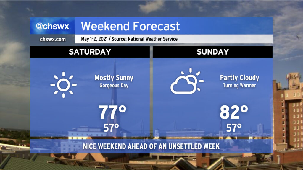
We’ve got a good-looking weekend queued up to start May. A cold front came through earlier today, and drier air is moving into the area from the north. This will make for a comfortable start to Saturday, with lows bottoming out in the mid-50s. Temperatures will rise into the mid-to-upper 70s under a mostly sunny sky — a really great day to get outdoors. Sunday will turn a little warmer with highs topping out in the low 80s under partly cloudy skies, but should still be quite nice.
As we get into next week, the pattern turns a little more unsettled with shower and thunderstorm chances each day through Thursday, though this should all settle out for another gorgeous weekend afterward. Enjoy!
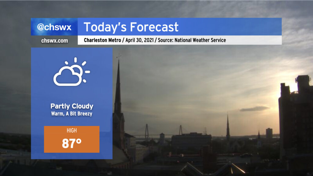
This morning, we find a cold front moving into the Upstate of SC. Said front looks to cross the area this afternoon with mostly little fanfare; expect mostly clear skies by sundown. Despite the front, today will be the warmest day of the week as deep downslope flow in the wake of the front allows temperatures to warm into the upper 80s. Dewpoints will trend downward, though, and it will feel pretty good outside despite the higher heat to close April. The weekend looks pretty good, with an especially nice day coming up on Saturday — more later today!
We’re going to feel a little more like late May than late April tomorrow as high pressure slides a little more offshore with strong ridging remaining aloft. Humidity creeps up a little bit, and with a little compressional warming beginning ahead of a cold front, temperatures will get into the mid-80s in the afternoon. We will remain rain-free for at least one more day given the ridging aloft; with only a slight chance of thunderstorms on Friday as the front swings through, it is conceivable we will stay rain-free through the weekend as high pressure builds back in behind it, cooling things off a little for Saturday.
Minor coastal flooding will remain an issue with the evening high tides through Friday. Winds will then shift offshore and lingering astronomical influences will wane, ending this cycle of coastal flooding.
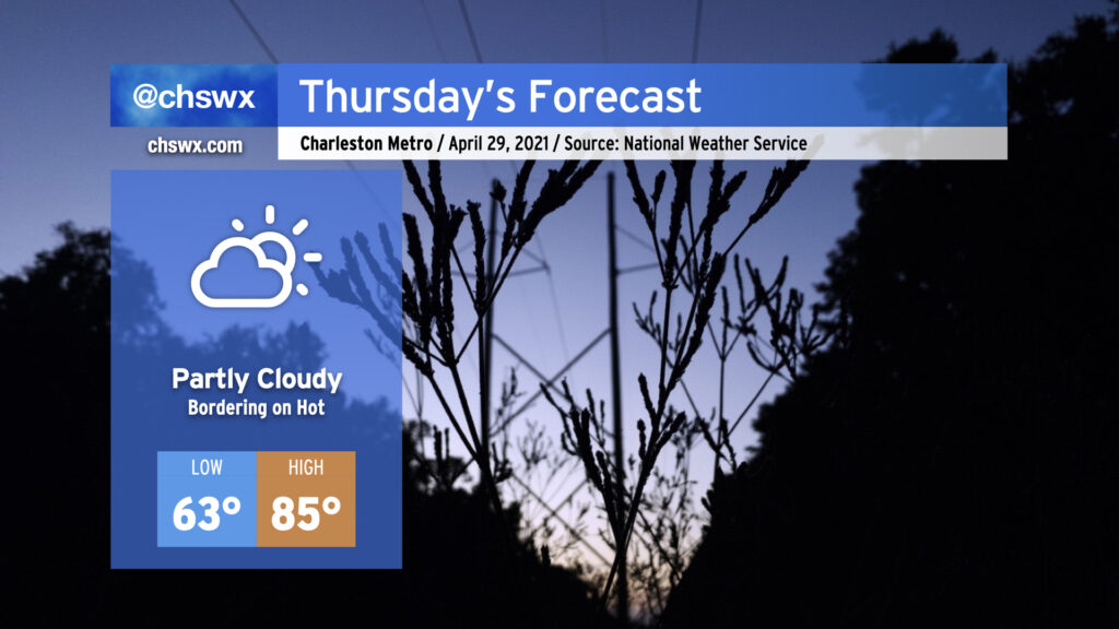
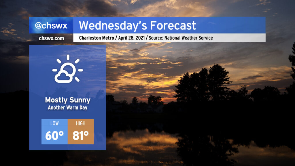
If you liked today, you’ll like Wednesday — we’ll get back up into the low 80s under mostly sunny skies. Temperatures will run a little warmer in the morning thanks to a little more cloud cover overnight, but will still be largely comfortable around 60°. The warming trend continues into Thursday, when we’ll reach into the mid-80s across the area ahead of a cold front. Said front looks to bring some showers and thunderstorms into the forecast for Friday, but the exact details of how rain will go down are still a little iffy. Stay tuned.
Coastal flooding will remain a concern with the 10:10 PM high tide Wednesday night as lingering astronomical influences and onshore flow persists. We’ll likely have another Coastal Flood Advisory as a result.
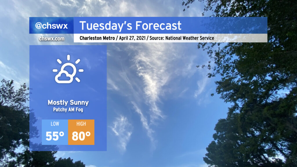
We’ve got another nice day ahead on Tuesday with high pressure remaining in control both at the surface and aloft. Temperatures will start in the mid-50s before rising to about 80° in the afternoon (it’ll run a few degrees cooler at the beaches) under mostly sunny skies. There could be a few patches of fog in the morning, but nothing too out of band.
We’ll want to keep an eye on high tide Tuesday evening for another round of minor tidal flooding. High tide is expected around 9:18 PM, and water levels could approach 7.2′. Be ready to reroute in case roads close or are otherwise covered with water.
April will come to a close in a very familiar way: Warm and rain-free. Monday looks excellent, weather-wise, with clear skies and highs topping out in the upper 70s in the afternoon with an onshore breeze. High pressure will slowly slide offshore over the next few days, and the resulting return flow along with pronounced ridging aloft will allow temperatures — and dew points — to creep up as the week goes on. By Thursday, we’re doing mid-80s in the afternoon ahead of a cold front. The forecast picture becomes somewhat murky as we head into the weekend, with some solutions keeping us rain-free and others bringing showers and thunderstorms into the area. NWS split the difference for now and is indicating a 20% chance of showers and thunderstorms Friday-Sunday, with the expectation that this is going to change. So, stay tuned.
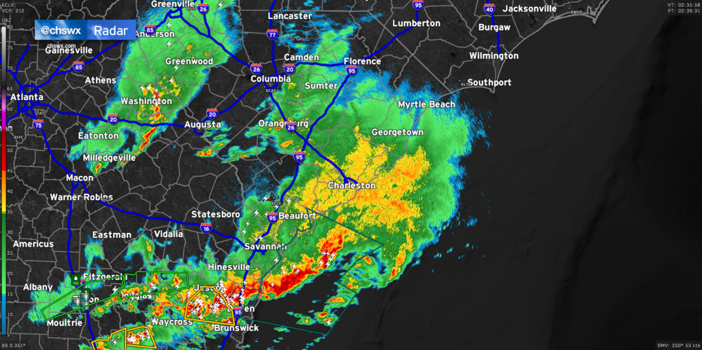
Radar continues to show light to moderate rain moving across much of the Lowcountry late this evening, with some embedded pockets of heavier rain. Showers and a few thunderstorms will remain possible for the next couple hours before tapering off after midnight. Most of this should be out of here by 2-3am.
The risk for severe weather has ended across the Charleston Metro Area, and tide levels continue to retreat after peaking shy of 6.4′ MLLW earlier this evening, so there are no further major weather concerns tonight.
Many spots saw over 1″ of rain based on reports. It’s much-needed, and it’s sure great to get it without all the extracurricular activity. We’ll have a few days to dry out before the next risk for rain arrives later next week.
We are largely hitting a lull in the rain across the area early this evening. Temperatures have settled into the mid-60s across the area, with skies remaining very overcast. Today’s rain has tamped down the severe weather threat pretty well, and with light showers still in the area and the amount of daylight waning, we should be in decent shape. Given the dynamics, one cannot totally rule out an isolated storm with gusty winds or hail, but the risk is very low.
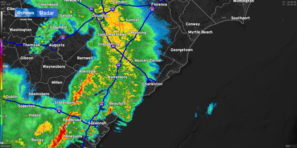
Our next round of rain is likely taking shape to our west, where the airmass did get time to recover and another round of strong to severe thunderstorms is ongoing. This activity will weaken as it heads eastward, but may hang on enough to bring more substantial rain into the area. Radar estimates suggest that we’ve generally received anywhere from .25-.75″ across much of the Tri-County, with the highest amounts in southern Charleston County as well as between 17-A and I-95 in Berkeley and Dorchester counties. It’s been a pretty decent soaking, and the good news is that there have been no flooding concerns of note so far.
Based on current timings, it looks like we will get past high tide before any more heavy rain moves in, which is good news for downtown. Of course, we’ll keep an eye on things until the cold front swings through late tonight, but so far, it’s turning out pretty good for us.
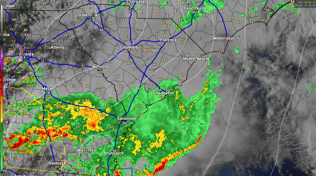
It’s been a while since there’s been anything of consequence on radar, but we are beginning to see some rainfall move into the Tri-County from the west now. Some embedded downpours and rumbles of thunder are certainly possible, but the severe weather threat remains low and should stay that way through the evening. Now that we have seen how storms are evolving, the risk for severe weather looks greatest along and south of Interstate 16 in Georgia. A tornado watch is up for Southeast Georgia until 6PM as a squall line moves through. This line stretches from Georgia southwestward into Florida, with the worst of the weather looking to stay south of the Charleston Metro Area.
A couple more rounds of heavy rain are possible through this evening, and we will still need to watch the 6:43 PM high tide very closely for the potential for flooding, especially if heavy rain is ongoing at that time. There remains a marginal risk that one or two storms could still become severe, too, so be sure you can still receive warnings this afternoon and evening. However, a widespread severe weather event is becoming increasingly less likely.