Jared Smith founded @chswx on Twitter in 2008 as an experiment in disseminating weather data through social media. In the ensuing decade-and-a-half, @chswx has provided live coverage of tropical cyclones, tornadoes, severe weather, and even a couple bouts of winter weather to the good people of Charleston, SC.
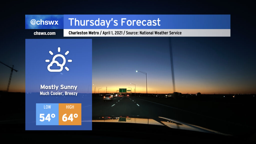
It was a busy weather evening, with numerous reports of hail inland from the coast, a lot of lightning, and a lot of heavy rain. The storms will give way to a cold front swinging through overnight, and by Thursday morning, we will begin to see quite a cooldown. We’ll go from a high of 82° on Wednesday to highs struggling into the mid-60s for Thursday. (No fooling.) It’ll be breezy in the wake of the front, too. However, the sun will be out, and the early April sun angle will feel pretty good when balanced with the cooler air temperatures.
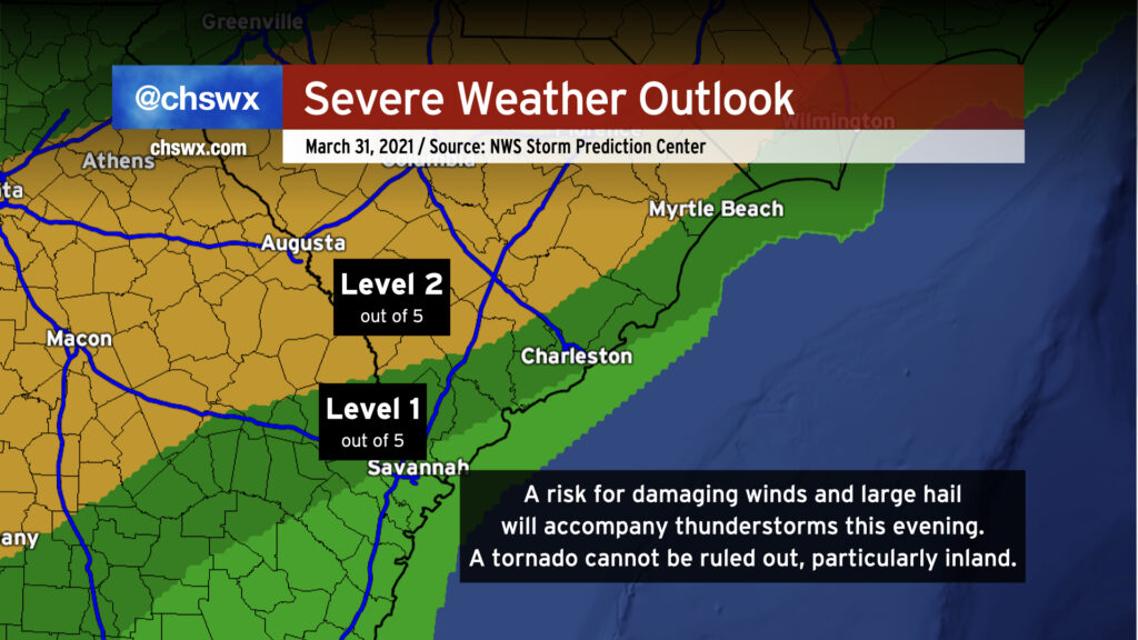
We’ll have a risk of some strong to severe thunderstorms later this afternoon into this evening as a sharp cold front swings through the area. We’ve had plenty of sunshine thus far, and that is certainly helping the atmosphere destabilize ahead of said front. Damaging wind gusts are the primary concern, but a tornado cannot be ruled out somewhere on the leading edge of the line as well. The greatest risk of severe weather generally lies along and west of 17-A as daytime heating and marine influences stabilize things closer to the coast, but severe storms will be possible pretty much anywhere in the Tri-County this evening; NWS is thinking between 6PM and midnight for our neck of the woods.
Stay close to reliable weather sources this afternoon and be ready to take action in case warnings are issued.
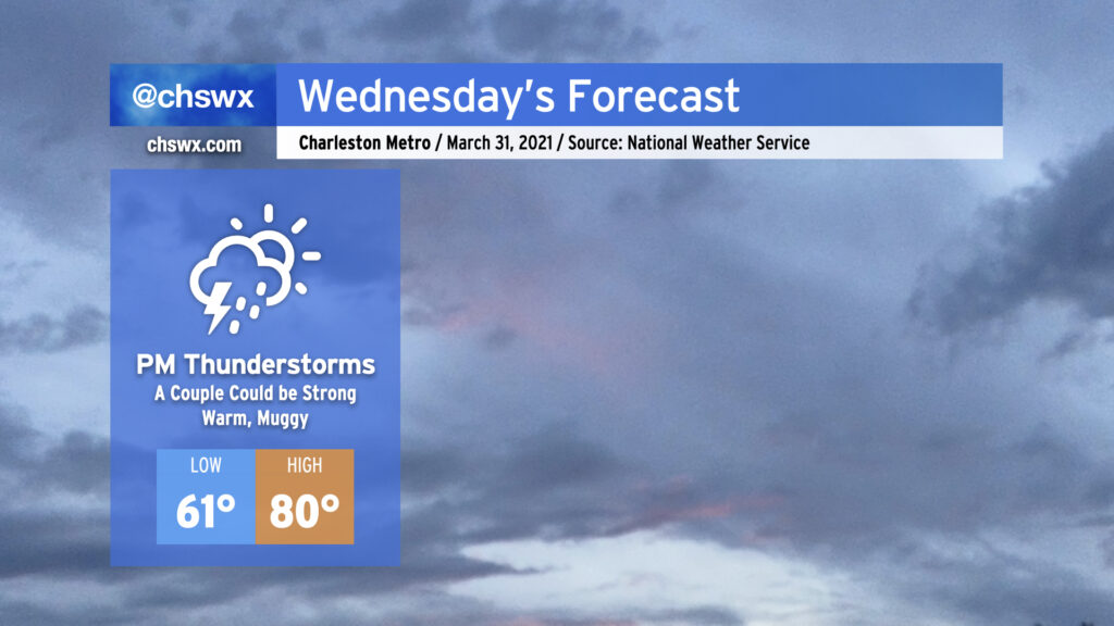
A cold front will approach the area from the west throughout the day Wednesday, with shower and thunderstorm chances increasing later in the day as the front gets closer. A couple showers or storms can’t be ruled out in the afternoon well ahead of it, but the best rain chances will start early in the evening through the overnight. One or two storms could turn strong with gusty winds and hail, especially for those of you who are further inland. However, widespread severe weather is not expected.
We’ll be at the apex of this week’s temperature rollercoaster with highs topping out around 80° in the afternoon. Afterward, it’s a much different story…
We’ll put scattered showers into the weather mix for tomorrow as a trough of low pressure sets up offshore, perhaps allowing a little rain to head up into our neck of the woods primarily in the morning to midday timeframe (with slight chances in the afternoon). Temperatures will warm into the lower 70s in the afternoon.
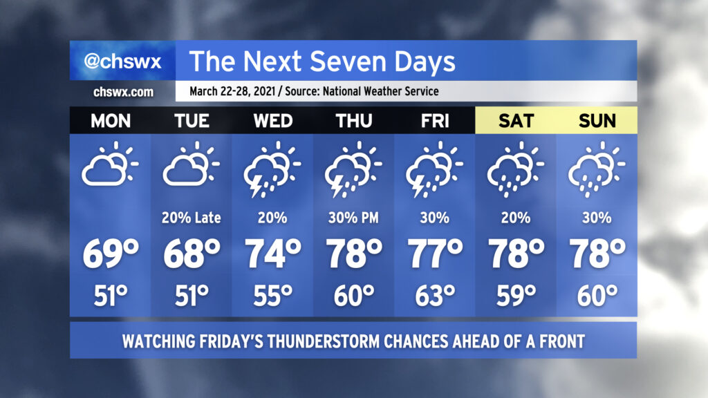
Tuesday night, a warm front will lift north of the area, which will prevent temperatures from falling much below the low 60s as we get into Wednesday morning. Highs will top out in the low 80s on Wednesday afternoon, with the risk of a few thunderstorms coming along for the ride as we are well into the warm sector of our next storm system. A couple strong to severe storms are not out of the question, either, so we’ll want to watch that potential. After the front gets through, the bottom falls out of the mercury, but at least the sun stays out into the weekend!
Spring, being a transitional season, will often give you its share of weather whiplash. This is going to be one of those weeks where your jacket and shorts should stay within equal reach.
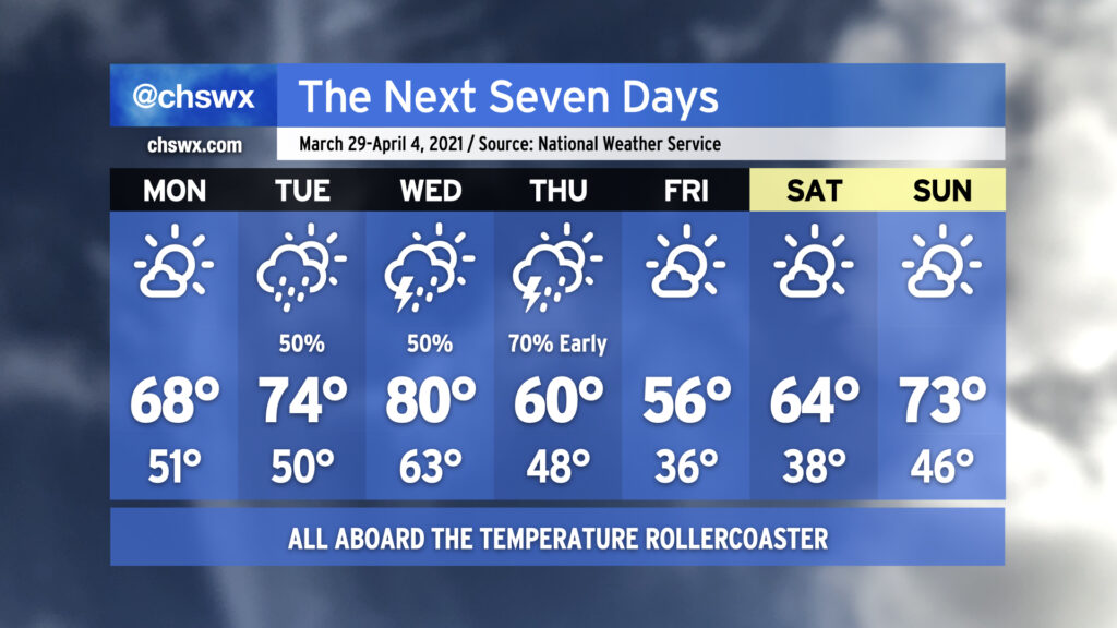
We start the week with high pressure asserting control over our weather, albeit briefly. It’ll be much cooler — we’ll start Monday in the low 50s. Late-March sunshine will be enough to push temperatures into the upper 60s, but that is still a little cooler than normal for this time of year. Temperatures moderate a bit on Tuesday as high pressure slips offshore, but we’ll also see shower chances return to the picture as well.
Our best thunderstorm chances this week come Wednesday into early Thursday as a warm front lifts north across the area followed by a strong cold front. We could warm to around 80° on Wednesday post-warm frontal passage before the mercury comes crashing back down to earth for Thursday, when temperatures will struggle to 60°. Frost and freeze issues could very well come into play Friday morning as temperatures dip to the mid-30s in the immediate Charleston Metro Area with colder temperatures, perhaps flirting with freezing, further inland. The high on Friday should only top out in the mid-50s despite ample sunshine, owing to the abnormally chilly airmass working its way into the area to help get April started out on a chilly note. The early April sun angle will help modify this airmass, though, with temperatures warming back to around normal by Sunday. It’ll be a nice weekend to get outside with plenty of sunshine and comfortable humidity levels expected.
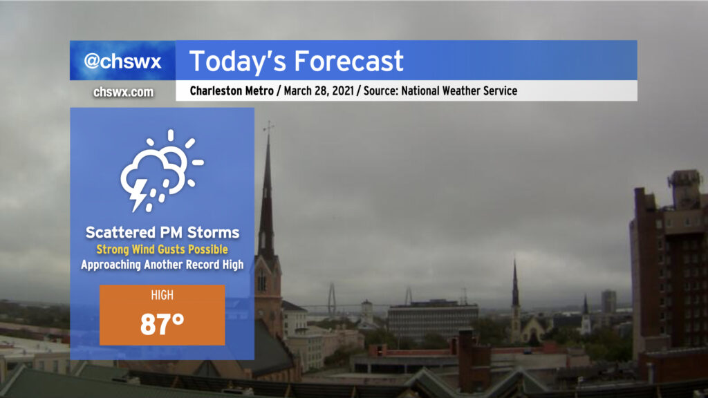
After two days of record warmth, we look once again to approach record highs ahead of a cold front. The NWS forecast high of 87° is one degree off the record of 88° set in 2017 — it’ll be close.
We are already seeing a few downpours pop off in the I-95 corridor near St. George and Holly Hill this morning. However, the better rain chances arrive this afternoon and evening as a line of thunderstorms ahead of a cold front approaches the area. I’d expect thunderstorms to be approaching the I-95 corridor around 4-6 PM, with the line — perhaps in a more broken, weakened state — moving through the Charleston metro area by early to mid-evening. Our risk for severe weather today is low, but not necessarily zero, as a couple storms could still produce damaging wind gusts as they move by (especially if they arrive early enough to interact with the seabreeze circulation). Water temperatures remain generally in the mid-60s, which should lend a stabilizing influence as the storms approach the coast.
As always, keep an eye on forecast updates throughout the day as arrival time estimates are fine-tuned and we see how trends evolve with the strength of these storms.
This weekend is going to have quite a summer-like feel to it with highs in the 80s and a slight chance of showers and storms each afternoon.
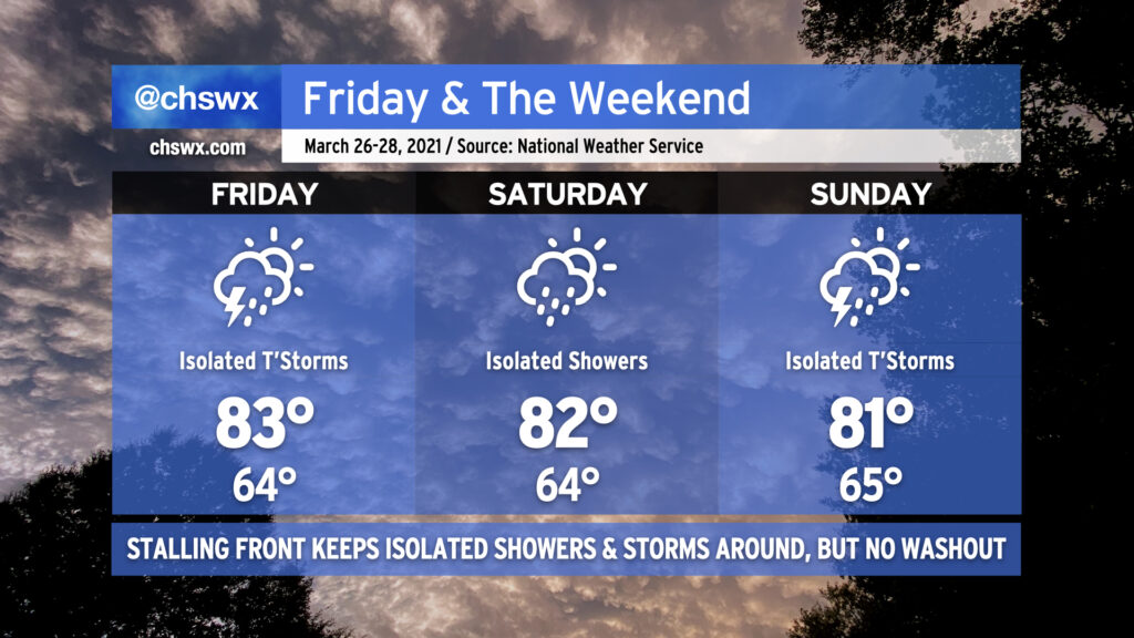
A cold front will be weakening and stalling out across the area Friday into Saturday. The front, a remnant of the strong storm system that is responsible for a severe weather outbreak in the mid-South today, will not be able to overcome the ridging aloft and strong surface high pressure. However, a few storms will be possible on Friday with the potential for one or two of them to produce damaging wind gusts and large hail. Widespread severe weather is not anticipated, though.
Getting into Saturday, we see the stalled front still in the area, perhaps acting as a focal point to kick off a few showers or storms. Otherwise, the story will be the warmth — lows in the mid-60s will continue to flirt with record high minimums, and highs in the low to mid-80s appear common, with potentially higher temperatures inland.
Another cold front will backdoor into the area from the north on Sunday. A few showers and thunderstorms will once again be possible ahead of said front, and a couple of those might err on the strong side, but once again widespread severe weather does not appear to be in the cards. This front will actually make it through the area, though, and by Monday, temperatures will be 10-15° cooler as high pressure wedges in from the northeast.
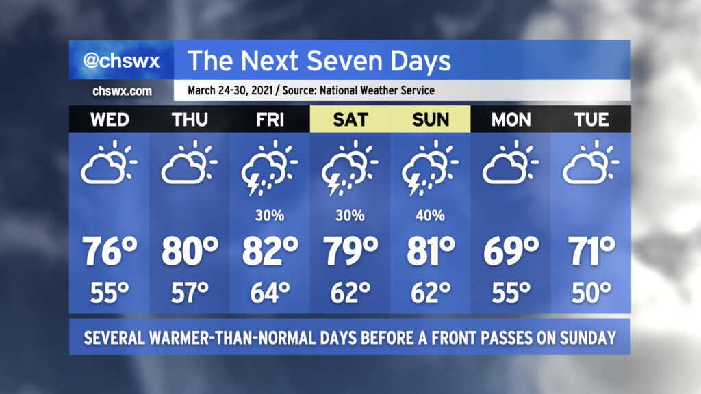
After temperatures overachieved today, we look to continue remaining a little warmer than normal as we go into Wednesday. Ridging aloft will continue to build over the next couple days, and by the end of the week we should be getting into the 80s ahead of a cold front that swings through Sunday. We look to remain rain-free through Friday, when a weakening cold front gets into the Carolinas and eventually stalls out and falls apart. While a strong storm or two can’t be ruled out, widespread severe weather is not anticipated.
As mentioned earlier, another, stronger cold front will swing through Sunday with a few thunderstorms, taking us back to closer to normal temperatures for Monday and beyond.
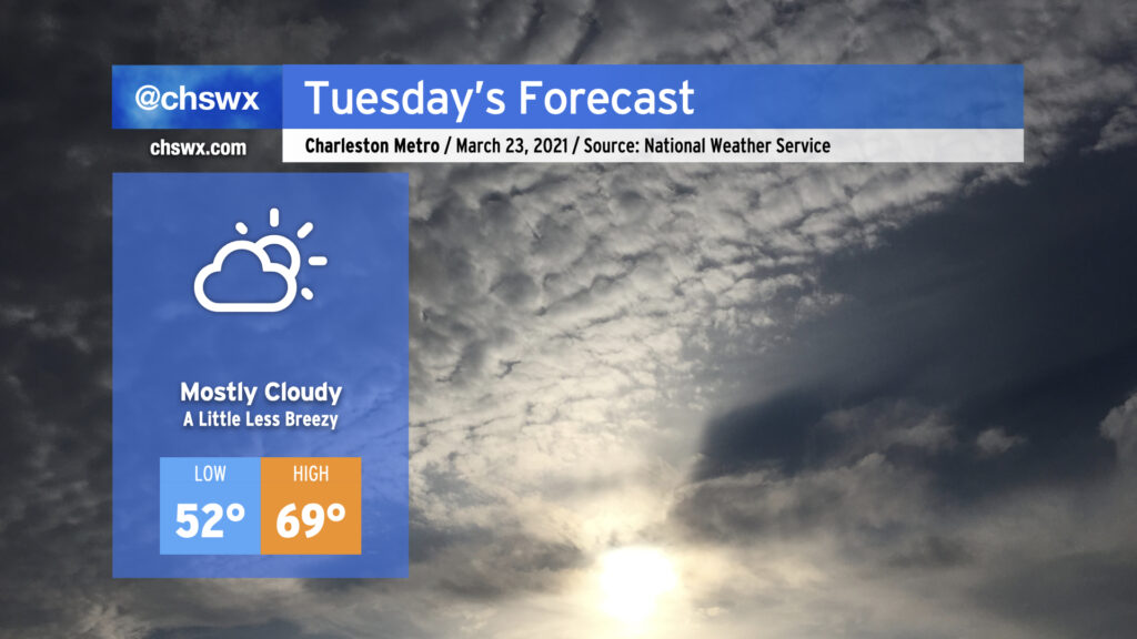
Cloud cover will look to be a bit more persistent on Tuesday, once again keeping temperatures right around 70° in the afternoon with low pressure stuck offshore, roughly about where the NC and SC border would be. Conditions should remain rain-free throughout the day, and we should get the sun peeking in and out as well.
We’ll be warming up as the week goes on — the last full week of March, already! — with isolated to scattered showers and storms possible beginning Tuesday night. The next significant storm system on the docket is expected to arrive sometime Thursday or Friday, but persistent low pressure keeps rain chances in the picture well before that.
Gusty winds will continue overnight into Monday, with 30-40 MPH gusts possible near the coast and on bridges. This is due to a tight pressure gradient between a wedge of high pressure inland and a surface low migrating northeastward off the coast. Northeast winds look to relax a little on Tuesday, but could still be gusty at times near the coast. A High Surf Advisory and a High Risk of Rip Currents is in effect for Monday — not a great beach day, for sure.