Jared Smith founded @chswx on Twitter in 2008 as an experiment in disseminating weather data through social media. In the ensuing decade-and-a-half, @chswx has provided live coverage of tropical cyclones, tornadoes, severe weather, and even a couple bouts of winter weather to the good people of Charleston, SC.
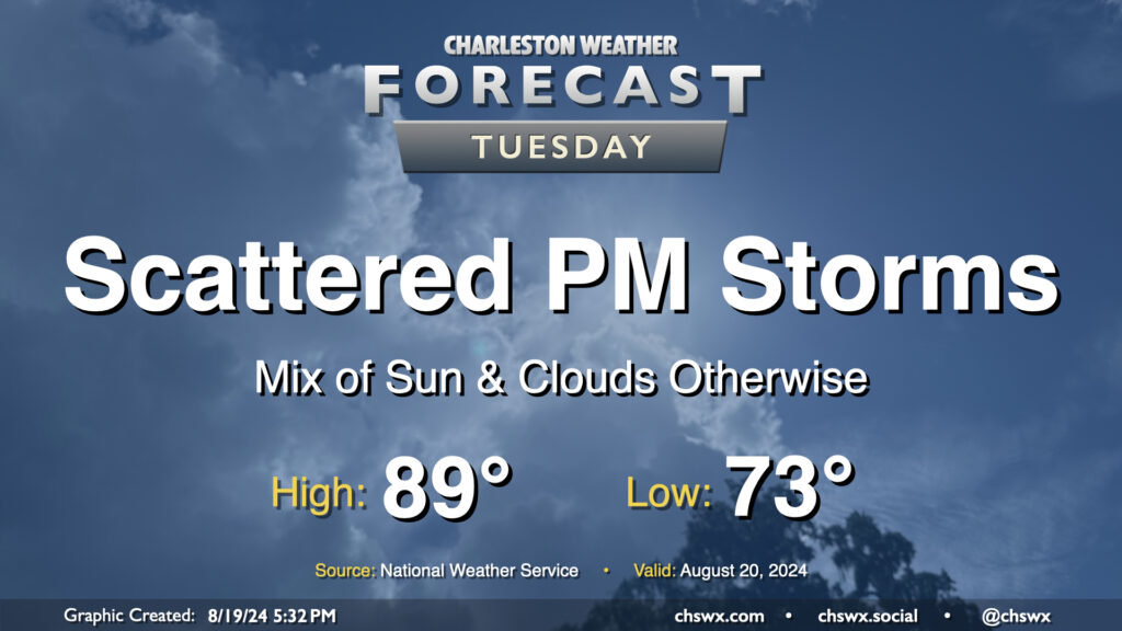
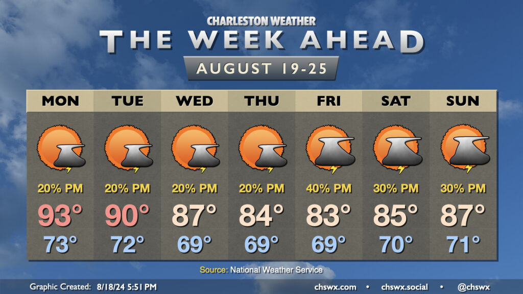
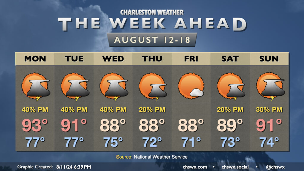
Tuesday looks a lot like Monday did (in the weather department, anyway) as a front continues to meander nearby, keeping the risk for a few showers and thunderstorms in the forecast in the afternoon primarily east of 17-A. Temperatures will follow a similar curve as well — we start in the low 70s (warmer toward the coast) and warm into the upper 80s to around 90° in the afternoon.
As far as storms go, a few folks could see some locally heavy rain thanks to slow storm motions, but otherwise, no severe weather is expected.
Another break from the heat is in the offing this week as cooler high pressure works its way into the area. We’ll really start to feel it beginning mid-week, and it should last well into the weekend.
One front gets by early Monday, stalling out nearby. This should cut down on coverage of afternoon storms, at least, but a couple storms can’t be ruled out as highs head to the low-to-mid-90s. The cooling trend begins on Tuesday as highs top out around 90°, and will continue for the rest of the week as highs fall into the mid-80s with minimal afternoon thunderstorm chances. Lows will bottom out in the upper 60s fairly routinely as well, with even some mid-60s possible in less urbanized locations.
Temperatures start to warm again as we get into the weekend, but highs should continue to run generally in the mid-to-upper 80s with scattered thunderstorm chances each day.
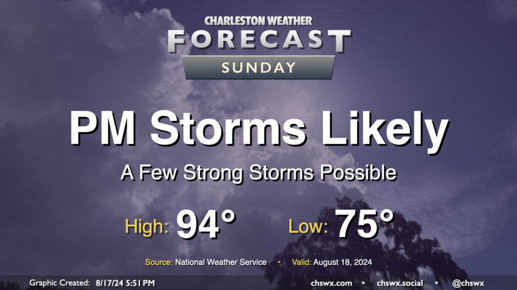
Well, we are back to the heat — briefly, at least — on Sunday as dewpoints head back to the mid-70s ahead of a cold front that could bring stronger storms later in the day. Expect air temperatures to peak in the mid-90s, with heat indices in the mid-100s — shy of the Heat Advisory criteria of 108°, but not by much — at the height of the afternoon.
Attention will then turn to the potential for strong to severe thunderstorms accompanying the front in the late afternoon and evening hours. A thunderstorm complex is expected to develop in the Upstate and will head to the Lowcountry as the day goes on. Given the heat and humidity, the atmosphere looks to be capable of sustaining strong to severe thunderstorms with damaging wind gusts as the main concern. Heavy rain will be a secondary concern, but these storms should be moving fairly quickly so any ongoing flooding shouldn’t worsen. Be ready for conditions to change in a hurry tomorrow evening, and keep an ear out for possible watches and warnings.
High pressure will gradually give way to another cold front this weekend, bringing humidity back to the picture particularly Sunday. However, the return to mid-70s dewpoints will be brief as slightly drier air moves back in behind the front next week.
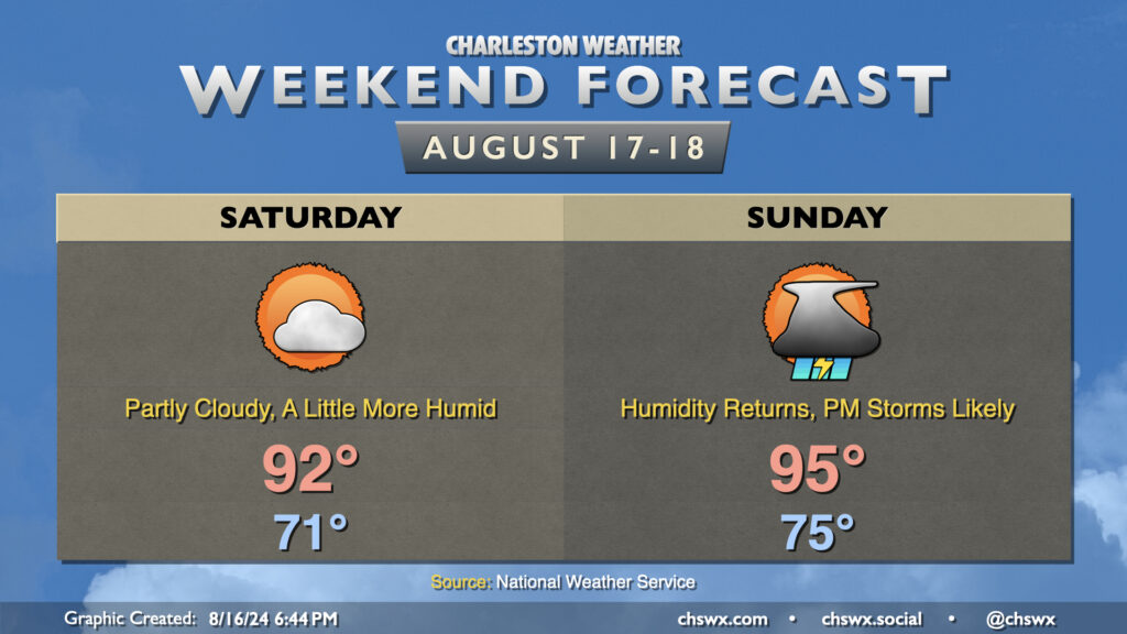
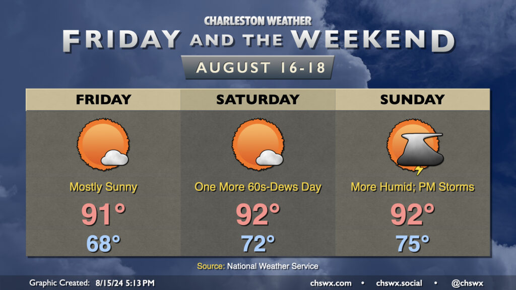
Saturday will run a little warmer than Friday did. After another cool-ish (relatively speaking) start in the low 70s, temperatures warm to the low 90s in the afternoon as dewpoints creep back up to the upper 60s. This will make it feel more like 95° or so — not a huge jump, but certainly warmer than it’s felt the past couple days. Expect rain-free conditions on Saturday with one more day of high pressure in control before it cedes ground to the approaching front on Sunday.
Sunday starts warmer — back to the mid-70s — and warms to the mid-90s in the afternoon. Dewpoints in the low to mid-70s will yield heat indices around 100-102° at the height of the afternoon. As the seabreeze moves inland and the front draws closer, expect showers and thunderstorms to develop. Guidance doesn’t show much to write home about with the seabreeze activity — generally scattered coverage — but a round of thunderstorms ahead of the front looks like a good bet as we get into Sunday evening. Shear and instability will be favorable for a few severe thunderstorms, with damaging wind gusts the main concerns (though some hail can’t be ruled out, either). If we get greater coverage of seabreeze storms, that could lower the severe weather risk locally, but we’ll need to see how that materializes. Keep an eye on forecast updates for Sunday evening, just in case.
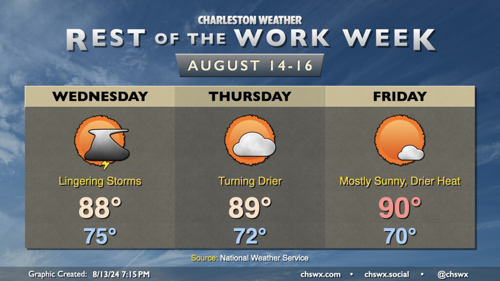
Friday and the weekend look mostly quiet as high pressure remains the main weather player for a few more days. We should start Friday in the mid-to-upper 60s in much of the metro (with low 70s on the coast); temperatures head to the low 90s in the afternoon under mostly sunny skies. With dewpoints in the mid-60s, the heat index could actually run slightly cooler than the air temperature (yes, this can happen!). So, while it’ll still be on the hot side, it won’t be quite as bad as it has been.
Winds go more southerly starting Saturday, and we’ll see a slow uptick in dewpoints as a result, but Saturday still looks quite good. We’ll start in the low 70s, warming to the low 90s in the afternoon under mostly sunny skies once again. Heat indices will run a degree or two warmer than the air temperature, but still generally not too out of bounds especially compared to what we’ve dealt with recently. Dewpoints creep back into the 70s on Sunday, and this will help drive a few scattered showers and storms in the afternoon and evening as another cold front approaches the area. We could see a stronger storm or two, but that’ll depend on the timing of the front. Overall, though, we should have a pretty good weekend of weather. And, given the fact that winds will go more southerly, the risk for coastal flooding is diminished for the upcoming weekend compared to yesterday’s forecast, though a little salt water on Fishburne at Hagood around the evening high tides could still be in play.
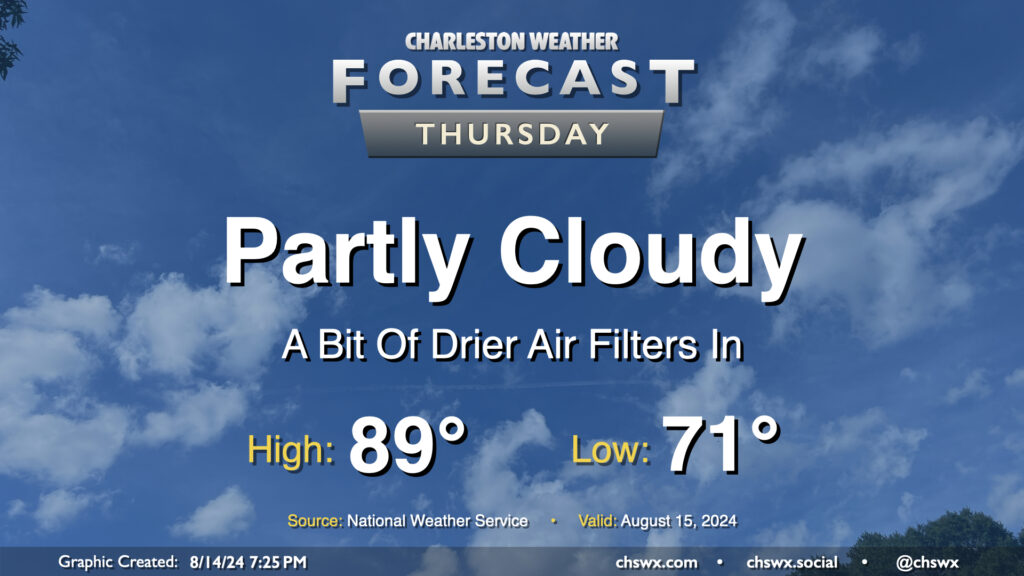
High pressure wedging southward across the area has brought some cooler and drier air to the area this evening, with dewpoints falling into the mid-60s (it’s been a minute!). This will yield a fairly nice (but still warm) day on Thursday. We’ll start the day in the low 70s and warm to the upper 80s in the afternoon under partly cloudy to mostly sunny skies. With the lack of moisture and influence of high pressure, rain isn’t expected (and won’t be for a few days). Overall, not too shabby for mid-August!
We have a bit of a respite from the rain and the extreme humidity on the way as a front slides south of the area and stalls tonight. Some lingering moisture and a trough of low pressure will allow for a few storms to remain in the forecast on Wednesday, though, as dewpoints slowly drop through the low 70s throughout the day. We start the day in the mid-70s and warm to the upper 80s in the afternoon, capped by some of that cooler and drier air trying to move back in. Expect the best chance of showers and storms from roughly 2-10PM. A few downpours can’t be totally ruled out as the deeper moisture only really starts to scour out Wednesday night, so a flood advisory or two could still be possible.
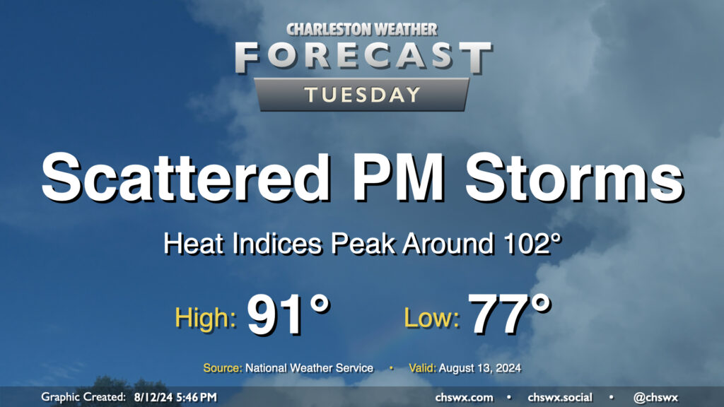
Tuesday’s forecast will continue to feature warm temperatures and afternoon thunderstorms as Berkeley and Charleston head back to school. We have another warm start ahead of us — generally expect lows in the upper 70s once again, followed by highs in the low 90s in the afternoon. This should run a couple degrees cooler with a little more onshore flow, but it’ll still be toasty with heat indices peaking around 102° before showers and storms fire. Once again, heavy downpours could cause localized flooding, especially near swollen rivers and streams and in urban areas, so stay alert for possible Flood Advisories.
Well, there will be decidedly fewer tropical cyclones impacting the area during the upcoming week, though we will still be living with flooding from Debby for the next few days along the Edisto and Ashley rivers as they continue to fall slowly from record (or very near-record) levels. We at least have something to look forward to as we head into the first school week of the year: some drier air punching in for late week.
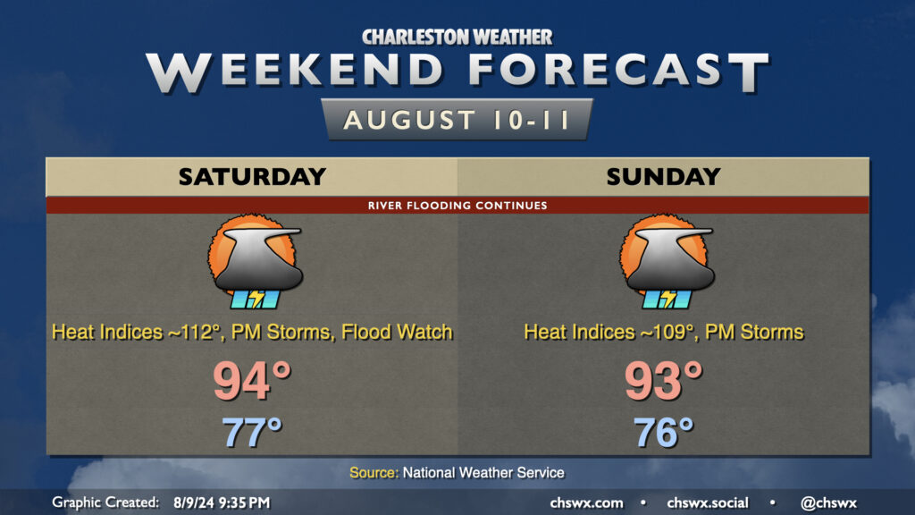
The first weekend after Debby will be a sweltering hot and occasionally unsettled affair as a front stalls out to our west and the seabreeze helps to kick off afternoon showers and thunderstorms. Expect to start Saturday in the upper 70s, warming to the mid-90s in the afternoon. Lingering tropical moisture characterized by dewpoints in the upper 70s will drive heat indices into dangerous territory well into the low 110s. We could flirt with Excessive Heat Warning criteria if it wasn’t for the expectation that showers and thunderstorms would fire on the seabreeze by midafternoon. Unfortunately, we may see yet another round of heavy downpours for places being impacted by the ongoing flooding in the wake of Debby, and so it appears the Flood Watch will continue through at least 10am Saturday. Folks around Ridgeville, Moncks Corner, and Huger will need to continue to monitor for possible Flash Flood Warnings. We should see another round of showers and storms fire on Sunday with a similar setup in place to Saturday, too. Air temperatures may be slightly lower, but heat indices will still run close to 110°, so we will continue to swelter throughout the day Sunday. A front will squeak through next week, though, and that should allow for a little bit cooler and slightly drier air (72° dewpoints vs. 78° dewpoints, so don’t get too excited) to get into the area. So, it won’t last forever. Hang in there.