Jared Smith founded @chswx on Twitter in 2008 as an experiment in disseminating weather data through social media. In the ensuing decade-and-a-half, @chswx has provided live coverage of tropical cyclones, tornadoes, severe weather, and even a couple bouts of winter weather to the good people of Charleston, SC.
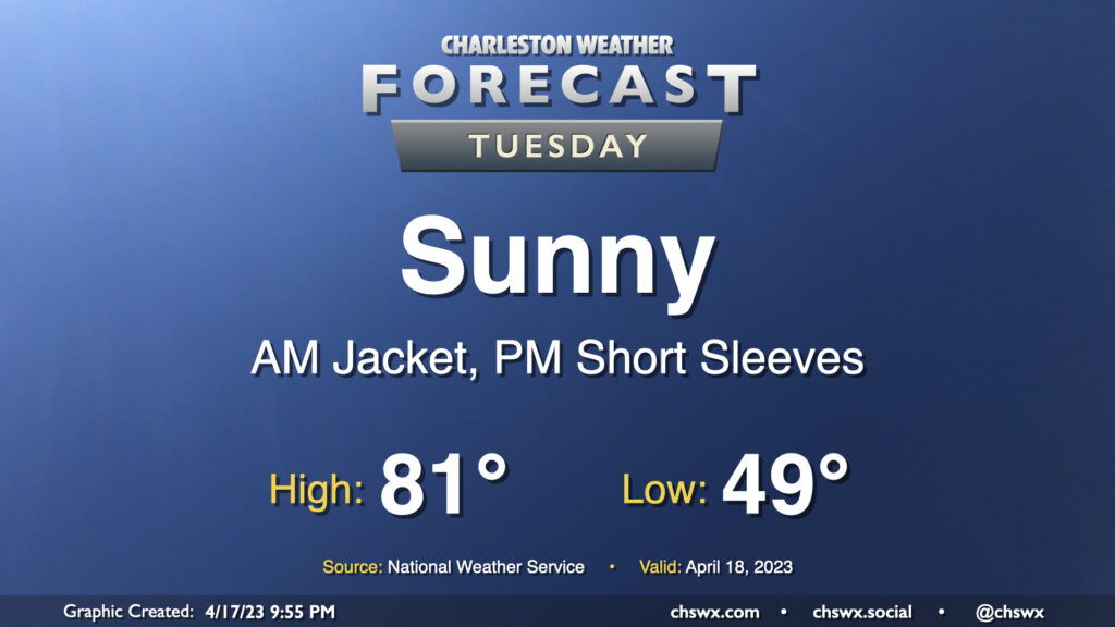
Tuesday will be one of those meteorologically brilliant days that will undoubtedly make all of us wish it was the weekend instead. We start the day in fairly crisp fashion with lows bottoming out in the upper 40s to around 50°. High pressure will sit atop the area, and this combined with a very dry airmass will keep the sky unmarred by cloud cover. Temperatures will respond nicely, warming about 30° to the low 80s in the afternoon. Winds will be a little lighter, starting out of the north and swinging around to the northwest, west, and finally south by sunset.
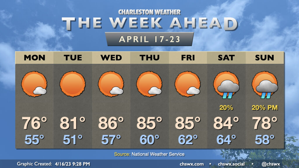
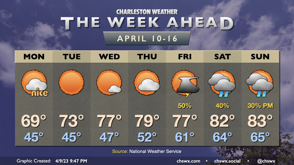
There’s not much to write about this week, weather-wise. A cold front coming through overnight Sunday will give way to expansive high pressure that will dominate the weather conversation for the next several days, primarily around just how much sunshine there’s going to be along with above-normal temperatures for mid-late April.
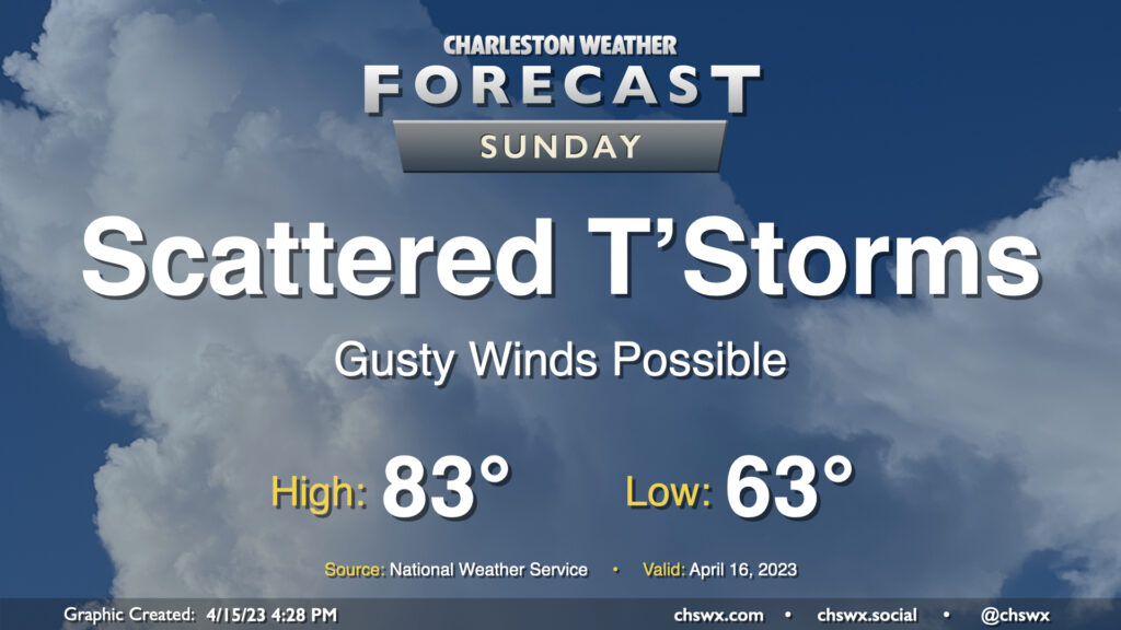
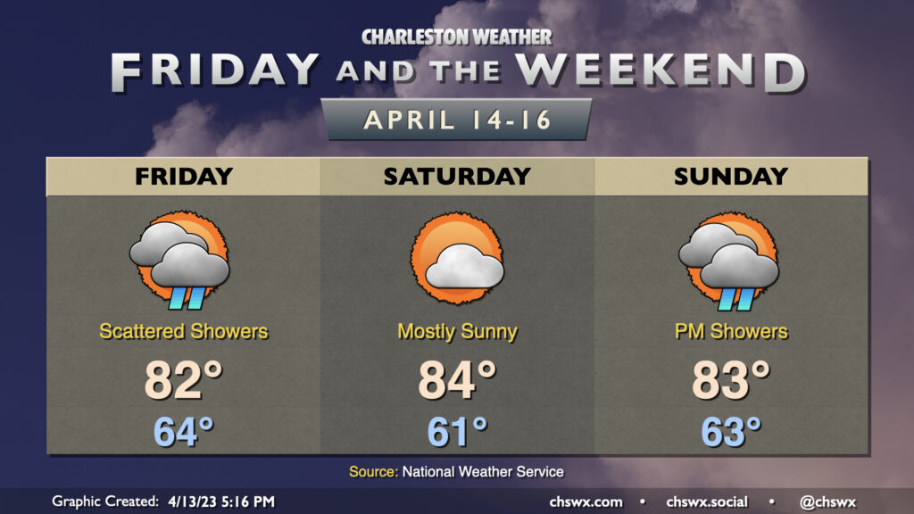
Sunday will not be rain-free, but it will not be a total loss, either, as a couple rounds of scattered showers and thunderstorms are expected — one in the morning, and then another late afternoon/early evening, with likely some dry time in the middle.
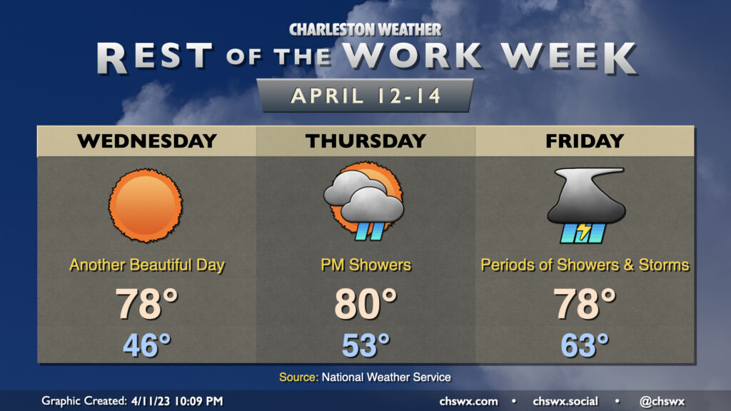
We will likely start the day with some showers in the area as temperatures bottom out in the low-to-mid-60s. These come on the heels of a decaying thunderstorm complex that, as of this writing, is moving over Alabama and the Florida Panhandle. This will pass by mid-morning, and we should see a stretch of reasonably quiet conditions before a cold front gets close to the area later in the afternoon/early evening hours. High temperatures should peak in the low 80s despite an uptick in cloud cover.
As the front approaches, a second round of scattered storms should fire, and a couple of those could be on the stronger side with damaging wind gusts the primary concern. Regardless, if you’re out and about and hear thunder, it’s time to find safe shelter indoors because all thunderstorms are dangerous due to the lightning they produce. This is especially critical for the later shows at High Water.
On balance, nobody will be socked in with rain all day, and some of you may not get any at all! That’s just how this works as we get into the later spring months, after all. The risk for showers and thunderstorms should end by mid-evening, with the front pushing offshore generally before midnight.
From here, beautiful weather ensues for much of the upcoming work week (as seems to be customary in 2023), with the next rain chances not for several days.
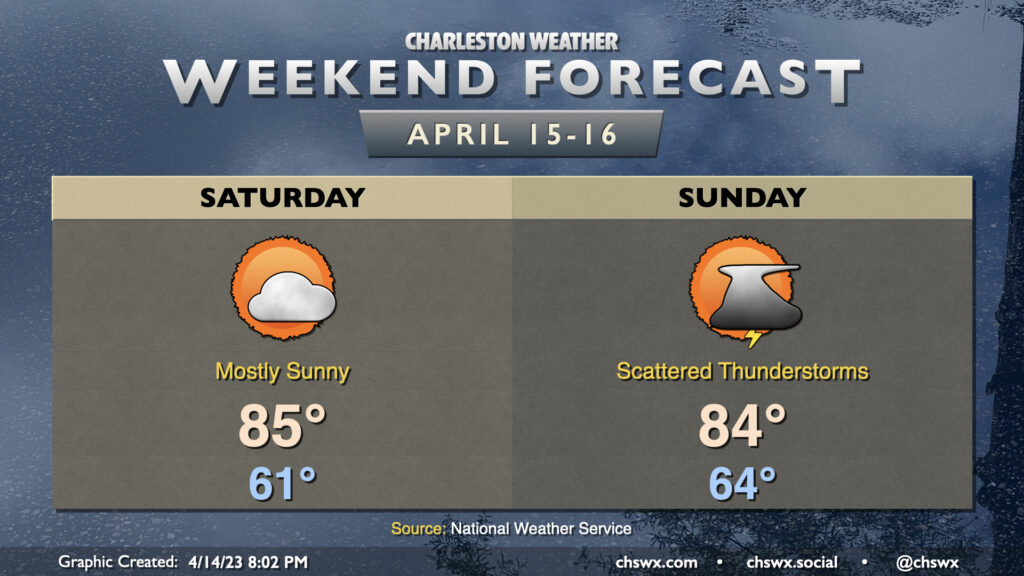
Warm weather continues this weekend, with a break in the rain coming Saturday as we’ll sit in-between storm systems. Highs on Saturday peak in the mid-80s after starting in the low 60s, several degrees above normal for mid-April. If you’re headed to High Water, make sure you’re applying sunscreen as the UV index will peak around 9, in the Very High category.
A cold front will approach the area Sunday, bringing with it the risk for some scattered showers and thunderstorms. Guidance is still somewhat mixed on the exact onset of these storms, but expect the best chance for a few thunderstorms in the afternoon and early evening. There is a small risk for a storm or two to produce damaging straight-line winds and some hail. Remember, though: Lightning makes every thunderstorm dangerous. When thunder roars, go indoors! Outside of storms, expect highs to once again top out in the mid-80s.
The front passes by late Sunday/early Monday, and the cooler and drier airmass behind it will bring us a pretty brilliant stretch of weather for the beginning of the work week. But let’s not think about the new work week yet if we can help it. 🙂
We’ll see some showers at times over the next few days, but there’s going to be ample amounts of good weather, too — crucial for this High Water Festival weekend.
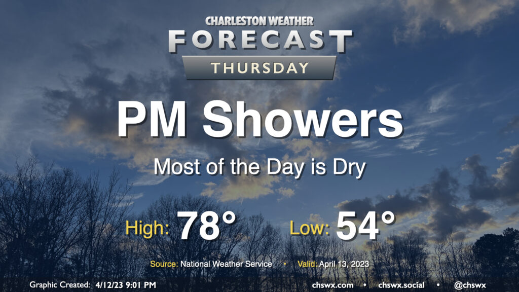
Showers return to the forecast later Thursday as high pressure slips offshore ahead of a low advancing northward out of the Gulf. We start dry and should get a good bit of the day in without rain, though. After starting in the mid-50s, highs will top out in the upper 70s as cloud cover increases ahead of showers. Expect the onset of rain roughly mid to late afternoon into the evening hours. It’ll be off and on, but could be briefly heavy at times. A little thunder can’t be ruled out, either. The best rain chances come after dark and persist into Friday.
Tuesday will be one of the better weather days we’ve had in a while around here, just an all-around gorgeous spring day. We’ll start the day in the mid-to-upper 40s and warm nicely into the low 70s in the afternoon under sunny skies. Dewpoints around 40° will yield a really comfortable day, too — not too dry, not too humid. Yes, it’s a workday, but with some of y’all on spring break, I hope you get to take advantage of this! Before you know it, we’ll be sweating buckets by merely stepping outdoors.
After an unusually chilly weekend, we’ve got a really nice start to the new work week coming up as cool, dry high pressure continues its hold on the area. We’ll still see a series of chilly starts through Wednesday, with lows in the mid-40s each morning. Highs gradually moderate through the period, peaking in the upper 60s on Monday, low 70s on Tuesday, and mid-70s on Wednesday under plenty of sunshine. Winds on Monday will still be a little on the breezy side, with occasional gusts to 30 MPH possible.
Thursday will represent one more rain-free day with a little warmer weather as highs peak near 80°. Low pressure advancing northward out of the Gulf will help usher showers and maybe a few thunderstorms into the area on Friday (though a total rainout looks unlikely). The overall airmass turns warmer, with lows in the 60s Friday morning offering a sharp departure from the last several days. Highs top out in the mid-70s with shower and thunderstorm activity likely tempering warmth. Scattered showers and maybe a thunderstorm remain possible Saturday into Sunday, though with far less coverage than Friday. Highs top out in the low 80s each day this weekend after starting in the mid-60s.
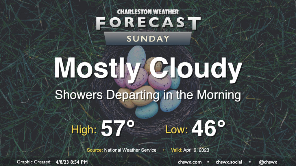
After a chilly, raw day across the area in which we tied the record cold high temperature, the rain comes to an end Sunday morning and we begin to dry out. Cloud cover will hang tough for much of the day, though we should get some peeks of sun late. One of the main weather stories for this Easter Sunday will be the continued chill; high pressure continuing to wedge into the area will keep highs in the mid-50s after starting in the mid-40s. If the NWS forecast high of 57° verifies, it’d be the second consecutive day tying a record cold high temperature.
The second weather story of the day will be the gusty northeast winds and the potential for major coastal flooding with the late night high tide. Winds will be brisk, sustained 15-20 MPH with gusts approaching 30 MPH at times, with even higher gusts possible at the coast and on the higher bridges. The persistent northeasterly wind will also drive tidal departures up over 2′, potentially pushing the 11:04 PM high tide up to around 8′, which is major coastal flooding territory. Fortunately, we’ll be done with the rain, and that will keep the flooding issues confined largely to tidal areas. Still, numerous road closures are possible late Sunday, and you’ll want to keep that in mind if you have late-day travel plans around downtown.