Jared Smith founded @chswx on Twitter in 2008 as an experiment in disseminating weather data through social media. In the ensuing decade-and-a-half, @chswx has provided live coverage of tropical cyclones, tornadoes, severe weather, and even a couple bouts of winter weather to the good people of Charleston, SC.
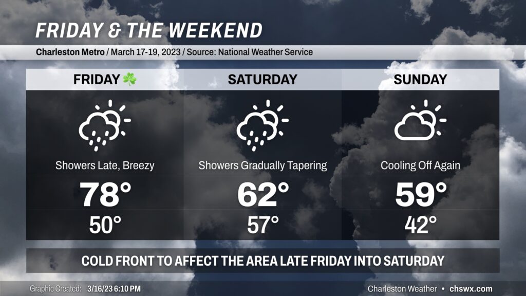
St. Patrick’s Day will be a warm one as southerly winds pick up ahead of a cold front. Gusts 20-30 MPH will be possible at times especially in the afternoon, which may have impacts on any outdoor activities. Expect highs almost 10° warmer than Thursday as they top out in the upper 70s. Increasing cloud cover will likely be the only thing keeping us from a run at 80°. We look to get much of the day in rain-free, though shower chances will be on the increase after sunset as the front draws closer. If your St. Patrick’s celebration extends into the night, you’ll want to keep rain gear handy.
Showers continue into Saturday morning as the front moves by. Scattered showers may continue to be an issue into Saturday evening, though I don’t see the day as a total rainout. Keep rain gear handy just in case, though. Highs look a lot different Saturday, with low 60s at best behind the front.
Skies go partly cloudy on Sunday with temperatures heading back below mid-March normals — struggling to 60° — as high pressure builds back into the area. We look to stay rain-free Sunday, so as long as you’ve got a jacket, the weekend isn’t a total wash.
Be sure you’re protecting pets and plants tonight as another period of freezing temperatures will be possible across the metro away from the coast. Even where temperatures don’t dip below freezing, calm winds will make for much more favorable conditions for frost to develop. So, regardless of where you are, be sure to cover those sensitive plants and have loved ones in and warm.
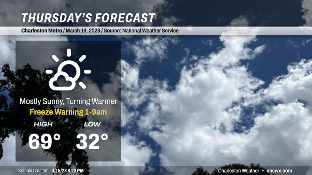
Thereafter, a warming trend will commence as high pressure starts to slip offshore, turning winds a little more southerly. We’ll see highs top out very near 70° on what should prove to be a nice Thursday across the metro area. A few more clouds will begin to fill in later in the day ahead of a cold front.
A Freeze Warning is in effect tonight across the Charleston metro area. Protect sensitive plants and bring in your pets tonight. We should stay just above freezing closer to the coast, but some frost can’t be ruled out. Best bet is to err on the side of caution and go ahead and protect that vegetation.
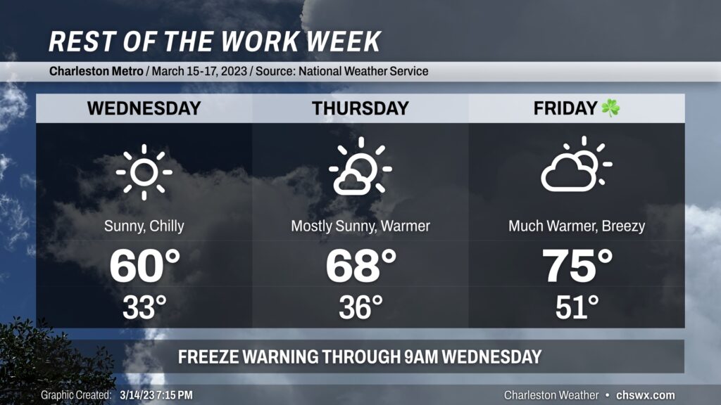
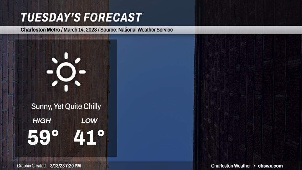
After an unexpectedly cool day in which temperatures did not get out of the 50s for the first time since February 18, we have another rather chilly day ahead for Tuesday despite full sunshine. Air temperatures to start the day will run in the low 40s in the immediate metro area (and cooler than that further inland), but factor in a decent 5-10mph northwest breeze and it’ll feel closer to the mid-30s in the morning.
As the day goes on, freezing levels will drop close to 4,000 feet and occasionally breezy northwest winds will continue to pump cooler air into the area, keeping surface temperatures in the upper 50s at best in the afternoon. This is more in line with early January normals than mid-March. A very dry atmospheric column will preclude anything in the way of cloud cover, so sunshine will be brilliant and unfettered at least, and should make the resulting cool air temperature feel a little better.
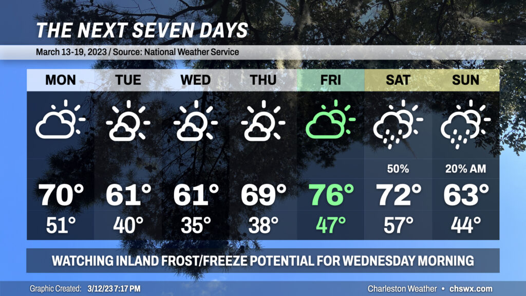
The main weather story for the week ahead will be a solid round of much cooler air affecting the area around mid-week. Some spots, generally inland of the coast, may run into trouble with some frost or freezing temperatures Tuesday night into Wednesday morning (and perhaps again Wednesday night into Thursday morning).
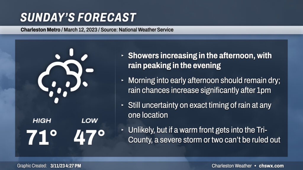
Sunday will start rain-free but with more clouds than sun as moisture builds down into the area ahead of a storm system which will lift a warm front very close by. Low pressure moving along this warm front along with the continued influx of moisture should be enough to kick off some showers and maybe even a thunderstorm starting early afternoon. The peak of the rain should be in the evening hours as the low makes its closest approach, with shower chances hanging around through about midnight. Temperatures will be in the 60s much of the day after warming out of the upper 40s during the morning. As the warm front peeks north, we could briefly touch 70° or so from the metro area southward, but I’d be prepared for a lukewarm rain.
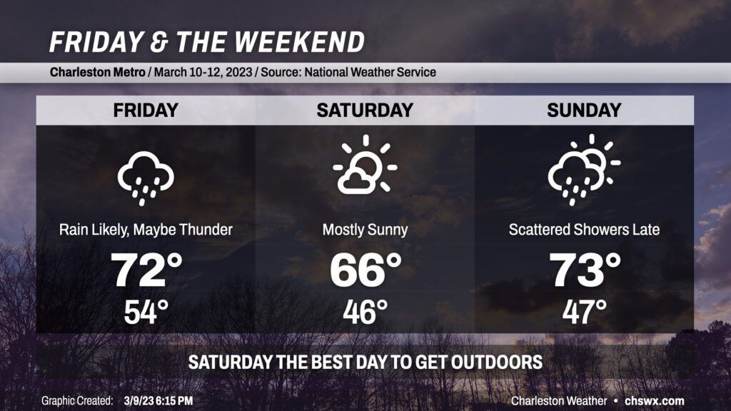
Clouds will be on the increase tonight as a storm system approaches the area from the west. We should remain rain-free through midnight before the atmosphere moistens sufficiently for showers to begin reaching the ground by tomorrow. Rain appears to be most likely from roughly mid-morning into early afternoon before cooler and drier air works into the area. Highs ahead of the front should peak in the low 70s despite the rain. A crack or two of thunder can’t be totally discounted, either.
Saturday is the pick day of the weekend for getting outside: it’ll run a little cooler and skies will be mostly sunny throughout the day. Expect highs to peak in the mid-60s after a start in the mid-40s. We should get Sunday morning in rain-free, especially near the coast, before precipitation chances head back up heading into the afternoon and evening hours. Highs should peak in the low 70s unless showers fire up sooner. The bulk of the rain looks to fall late Sunday into early Monday morning before a reasonably strong cold front punches through the area to send temperatures below normal for a few days next week. Stay tuned for timing changes on the rain as well as potential frost concerns for the middle of next week.
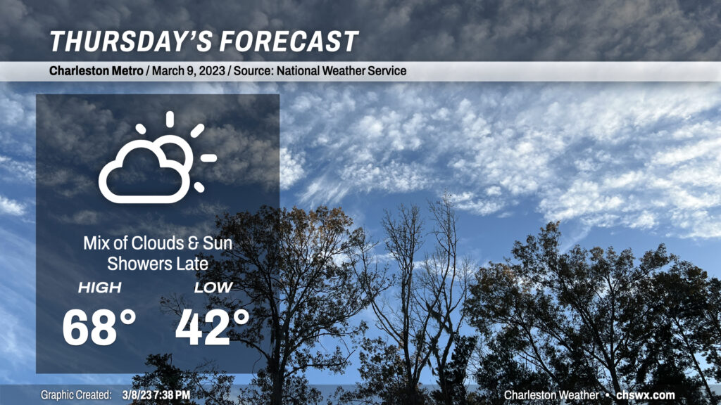
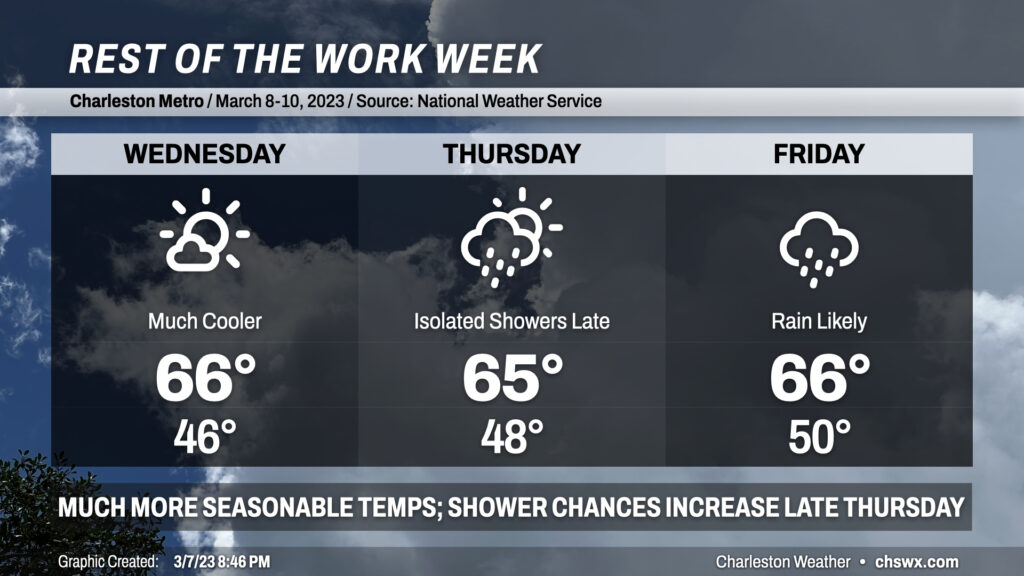
More seasonable weather for early March continues on Thursday with a few more clouds working their way into the area ahead of a storm system that’ll bring rain our way on Friday. We’ll start the day in the low-to-mid-40s before warming to the upper 60s in the afternoon. Rain chances should hold off until after midnight.
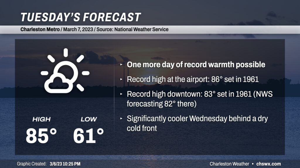
Today’s high was 87°, breaking the record of 86° set in 1961 while also being the warmest day of the year so far in 2023. Downtown got in on the record warmth action, too: the high of 84° broke the record of 83° set in 1945 and tied in 1961.
This changes drastically starting Wednesday. Lows in the 60s turn into lows in the mid-40s; highs in the 80s drop off 20°+ to the mid-60s in the wake of a front that is ushering in some much more seasonable — if not slightly below normal — temperatures for this point in the year. Winds may be gusty overnight as the cooler air moves in, and we’ll stay a little breezy through a good bit of Wednesday. The ongoing cool advection will counteract the otherwise mostly sunny skies to yield those mid-60s highs.
We’ve got one more day in the 80s coming up for Tuesday before the May-like warmth takes a backseat to more seasonable March temperatures. Temperatures will soar into the mid-80s in most spots except at the immediate coast as winds out of the west and northwest pin the seabreeze. We look to threaten record highs both at the airport and at downtown Charleston one more time — 86° and 83°, respectively, both set in 1961 — before a cold front sweeps through the area in the late afternoon/early evening hours.
Dewpoints will fall throughout the day as low-level moisture mixes out into an increasingly dry airmass. Once the front gets through, temperatures should hold in the upper 70s before falling quickly once daytime heating is lost. The front will pass through with little fanfare other than a wind shift more toward the north and then the northeast as cool high pressure builds in behind it. We’ll bottom out on Wednesday in the mid-to-upper 40s — easily the coolest start to a day since mid-February — and only top out in the mid-to-upper 60s in the afternoon, perhaps as much of a 20° drop from Tuesday’s high!