The week ahead: Unsettled, though we could use the rain
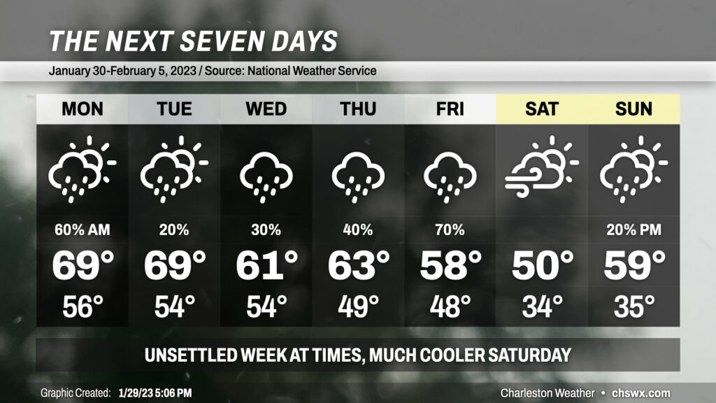
“Unsettled” is probably the best way to put this week’s forecast as we expect periods of showers throughout the period.
Read more »“Unsettled” is probably the best way to put this week’s forecast as we expect periods of showers throughout the period.
Read more »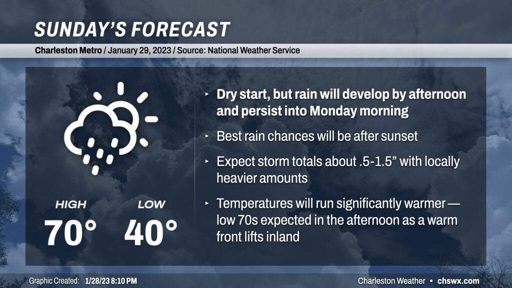
We’re not looking at a total washout for much of the day, but expect showers to develop later in the day on Sunday as a warm front pushes ashore along with some mid-level energy rippling about. Before rain sets in, temperatures should top out around 70°, making for perhaps some short sleeves weather for a time. Shower chances increase around sunset, peak overnight, and will linger into Monday morning. This could be another decent soaking for us, especially given moderate drought conditions across a good bit of the Tri-County area — expect storm totals between .5-1.5″ across a good chunk of the area with locally higher amounts possible. The good news is that no flooding issues are anticipated, and there’s no severe weather risk, either.
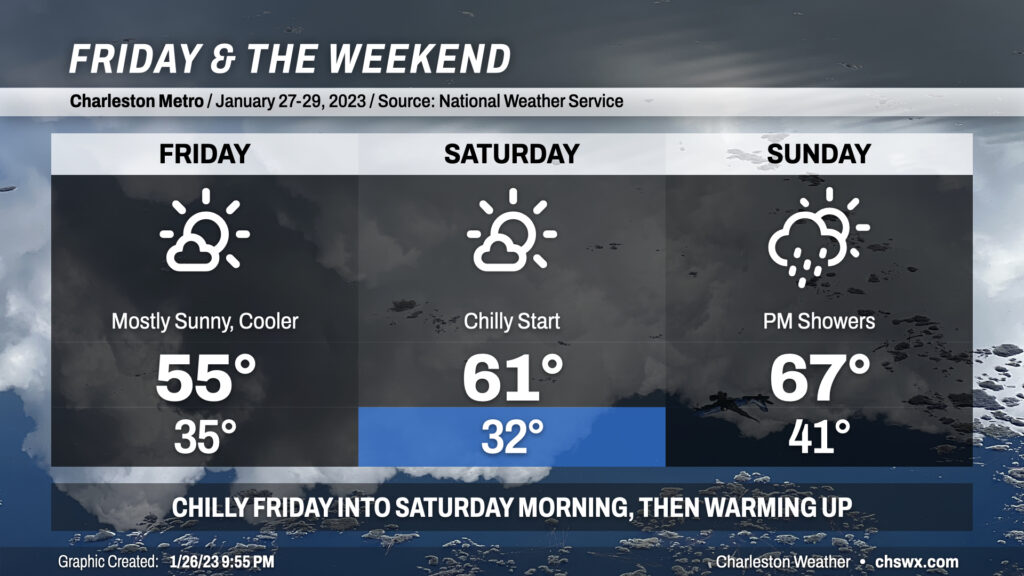
Cool weather will kick off Friday and the weekend as we sit under the influence of high pressure for a couple days before it shuffles back offshore later Saturday into Sunday. Expect lows in the mid-30s on Friday before warming just into the mid-50s despite plenty of sunshine; this is due to a trough axis in the mid-levels passing by to the north. We’ll see this feature give way to more zonal (west-to-east) flow as we get into Saturday, which will start around freezing but will rebound into the low 60s as high pressure begins to move east of the area. Temperatures — and dewpoints — then climb quickly on Sunday ahead of a storm system that’ll kick off rain showers in the afternoon, with the best chances for rain arriving late Sunday into Monday. Highs on Sunday should top out in the mid-to-upper 60s, foretelling a fairly warm end to January with highs next week approaching the 70° mark to close out the first month of 2023.
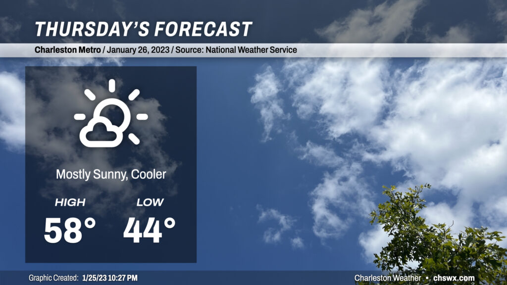
We are back into cooler weather on Thursday in the wake of a cold front which will sweep through the area overnight. We’ll start the day in the mid-40s with a bit of a westerly breeze that’ll stay persistent throughout the day. Clouds will be few and far between, but the ongoing influx of cold air will keep highs pinned into the upper 50s. Overall, though, a rather nice if not slightly-cooler-than-normal January day lies ahead.
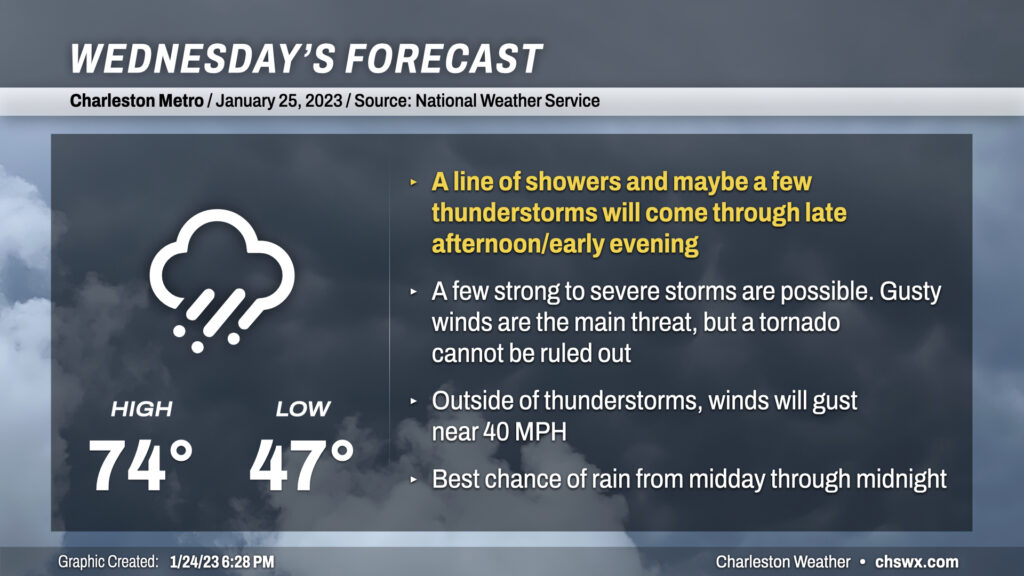
Wednesday could be a busy weather day here in the Lowcountry as a very dynamic storm system moves into the eastern half of the continental US, dragging a cold front through the Southeast throughout the day with showers and thunderstorms ahead of it.
Read more »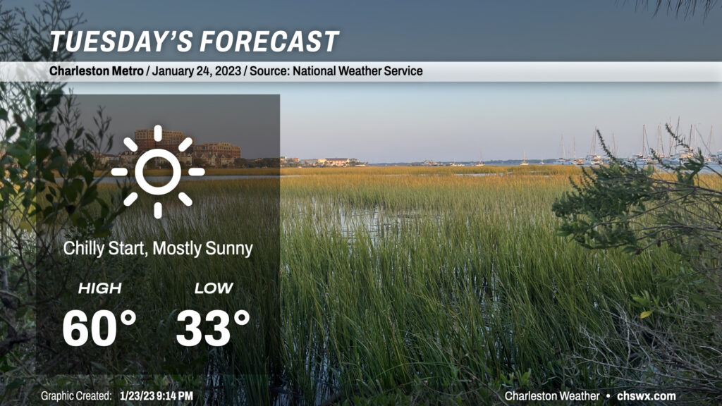
There’s not too much to write home about in the weather department for Tuesday. We’ll get off to a near-freezing start in the metro area, with temperatures dipping below 32° further inland as well as in more rural spots. Plenty of sunshine, though, will help drive temperatures to around 60° in the afternoon. Overall, a bright, brilliant late January day.
Read more »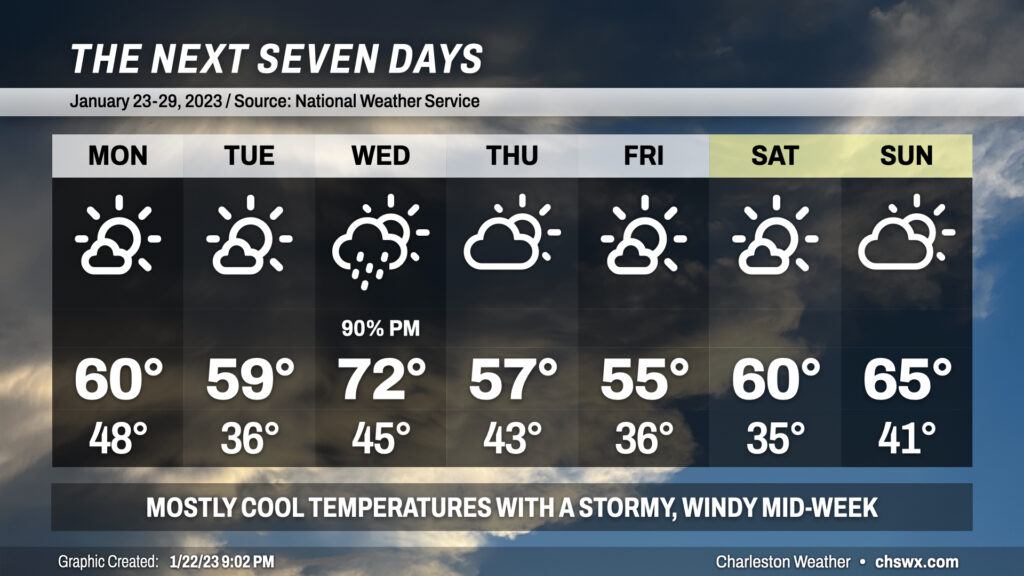
The week ahead will feature temperatures generally at or slightly below normal for this point of the year aside from Wednesday, when temperatures will head into the low 70s ahead of a cold front.
Read more »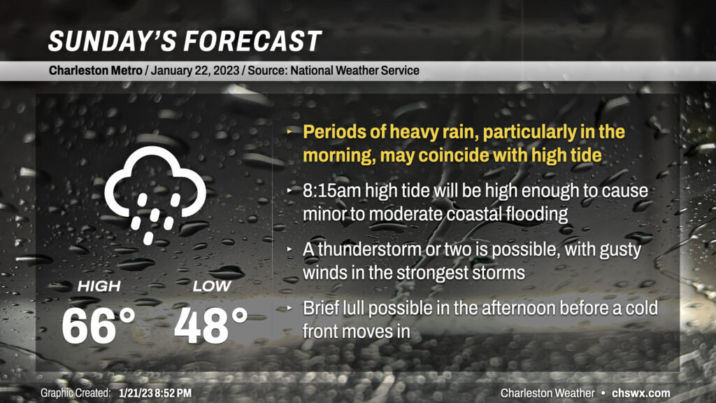
Sunday will be an active weather day across the area as a somewhat complex storm system moves through the Southeast US. Needed rain will fall throughout the day, but some of that rain might be heavy at times near a morning high tide that would cause flooding on a sunny day.
Read more »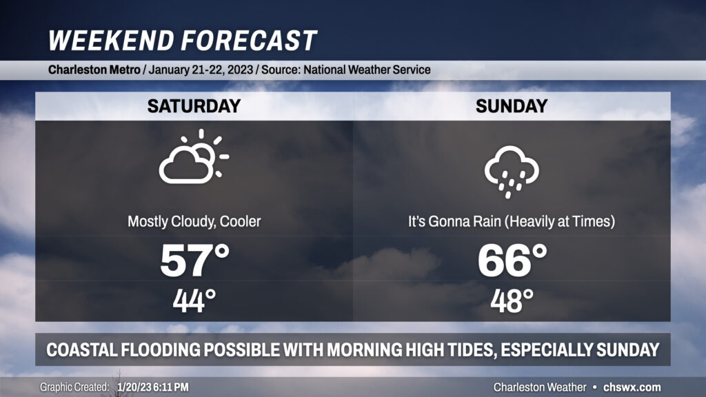
Despite thickening cloud cover and a cool wedge of high pressure building in Saturday, it’ll be the day to do anything outside as Sunday looks more active with some heavy rain at times and maybe some coastal flooding in the morning to boot.
Read more »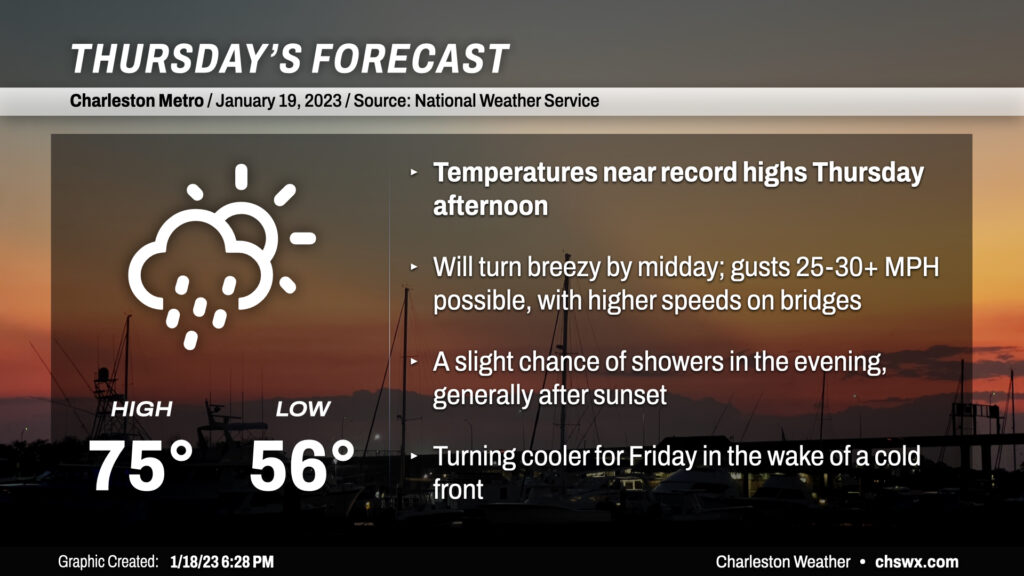
Thursday will be quite a warm day ahead of a cold front that will swing through late night/early Friday morning. We’ll start the day some 15+° above normal as lows only bottom out in the mid-50s. Temperatures will head into the mid-70s in the afternoon, with some upper 70s possible in spots.
It’ll be a bit of a windy day: expect winds to kick up to 15-20 MPH sustained with gusts 25-30+ MPH particularly in the afternoon hours. Higher speeds will be possible on bridges, and a Lake Wind Advisory is in effect for Lake Moultrie tomorrow as well. Hold on to your hats and steering wheels if navigating the bridges is in your travel plans tomorrow.
There will be a slight chance of showers as the front gets closer Thursday evening. Some of the high-res guidance sparks some additional showers as a remnant boundary ahead of the front itself perhaps intersects a seabreeze, but widespread heavy rain is not expected and no thunderstorms are forecast.