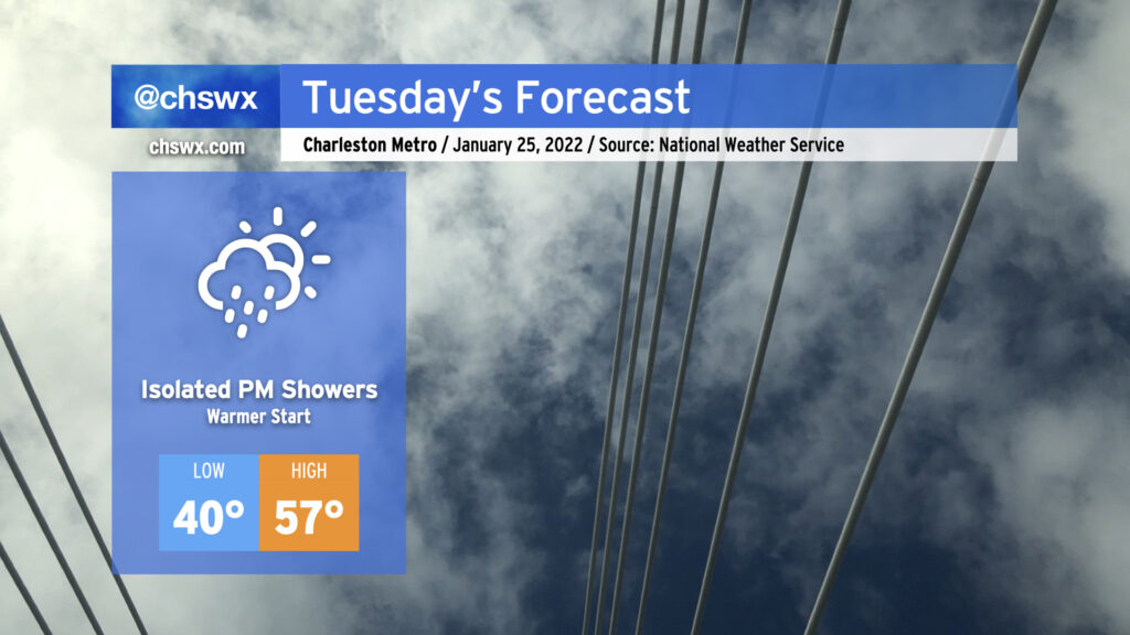
Low pressure moving along the Gulf Coast will keep a little more cloud cover in the area for Tuesday than we saw on this brilliantly sunny Monday. That will have the effect of keeping temperatures right around 40° to start the day, a touch warmer than we started with today and definitely warmer than how we started the weekend. Highs will rise back into the mid-to-upper 50s with winds coming out of the west. This is still cooler than normal for this point in January, but decent considering the expected broken cloud cover in place.
A shower or two will be possible in the afternoon and early evening hours mainly near the coastal areas as the aforementioned low pressure moves on by, but the vast majority of us look to stay rain-free. If it does rain, it may not even be measurable.
I’m also continuing to monitor model trends for scuttlebutt around a potential coastal storm this weekend. If you’re looking for another dose of winter weather, today’s trends aren’t ideal: model agreement has been improving in keeping the low pressure system in question well off our shores, with the GFS and ECMWF now in a bit more agreement on bringing drier air into the area before the colder air arrives. While the two models did a better job lining up today, I’m going to need to see a bit more run-to-run consistency overall before confidence in any one solution can improve.
For its part, NWS has a 40% chance of rain — and that’s it — for Friday afternoon into early Saturday morning, and if you need to be making any decisions about your weekend, that’s the forecast you want to be following. Stay tuned, for future adjustments to the forecast are more likely than not.
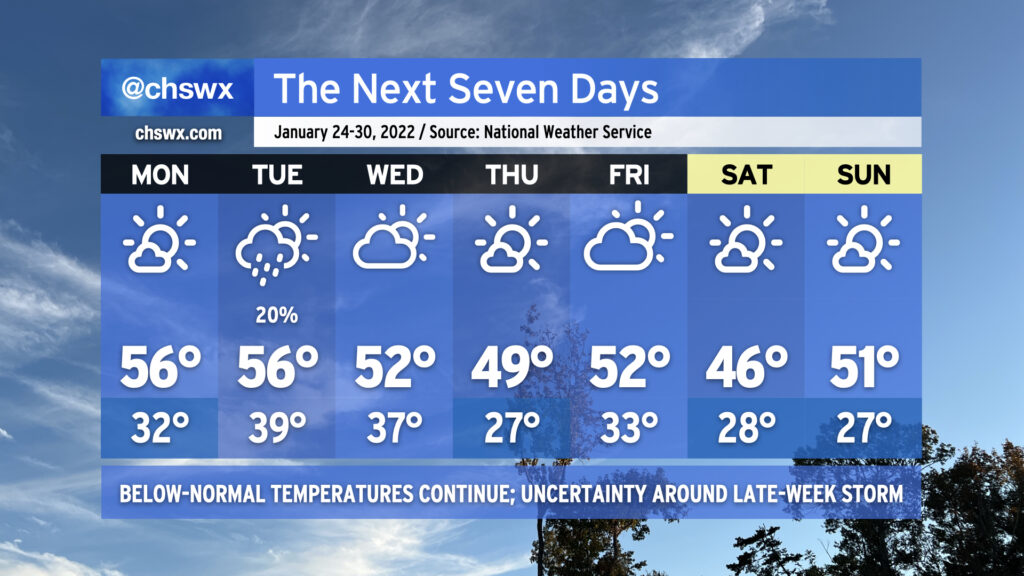
Overall, the forecast is looking a bit quieter (at least right now) as we head into the final full week of January (yes, already). Below-normal temperatures (normal highs for late January are around 60°) will continue as the overall pattern continues to show a ridge in the west and a trough in the east, keeping this side of the country in cooler temperatures and in a more active storm track overall.
Monday looks to be a repeat of today without the 21° start or the falling ice onto the Ravenel Bridge. We’ll start the day again around freezing, but that will be fairly short-lived as temperatures will top out in the mid-50s under mostly sunny skies. Low pressure sliding south of the area could toss some moisture in play on Tuesday with a slight shower chance across the area, but temperatures will remain above freezing. We run a little cooler Wednesday and again on Thursday as a front comes by, with another hard freeze possible overnight Wednesday into Thursday.
By Friday, the forecast becomes a bit more uncertain as we watch for an area of low pressure that looks to develop off the coast of Florida and move northeastward. The global models are pretty far apart on the position of a trough that would push the low further offshore. Right now the ECMWF (Euro) solution favors a dry forecast for us, while the GFS has been slower on the trough and thus keeps the low a little more eastward, spreading some precipitation ashore. We’ll wait to see how things develop, but for now, NWS has kept the area rain-free as we head into Friday and the weekend, which will continue to be significantly cooler than normal. Right now, the forecast shows mornings in the 20s and highs in the mid-40s on Saturday and low 50s on Sunday with generally quiet weather. Stay tuned for changes here, though.
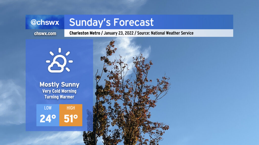
We’re headed into the coldest night of the season in the wake of last night’s winter weather. Temperatures will easily drop into the mid-20s and even lower — perhaps scraping the upper teens in the northern part of the Tri-County — which will be our first real bout with pipe-busting cold so far. Make sure you’ve got a faucet running on a drip and your pets have a warm place to be tonight. If you’re traveling, slick spots are not out of the question tonight into tomorrow, so please be careful on the roads.
After that frigid start, temperatures will warm into the low 50s for Sunday afternoon. Certainly chilly, but downright balmy when compared to today’s high of 38°. We’ll have plenty of sunshine to close out the weekend, and that should help finish the job on any remaining ice issues.
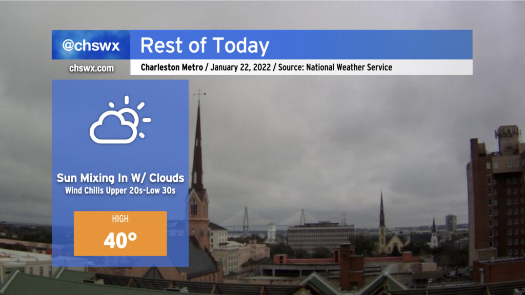
Cloud cover will continue to break up as the day goes on, and yes, most of you should see at least some periods of sunshine before the day is out. Temperatures, however, will struggle to around 40° as much of that energy goes to melting ice and sleet accumulations. Winds out of the north will still be a bit brisk, with wind chills dropping into the upper 20s to low 30s at times.
Roads will continue to improve throughout the day, but traveling is still probably unwise until mid-afternoon at least as there are still reports of troublesome bridges and overpasses.
We’ll want to see the degree of melting and drying that can happen today into tonight. We’re looking at the coldest night of the season so far tonight into tomorrow morning, so the risk for black ice redeveloping is something we will want to keep an eye on as we head into Sunday.
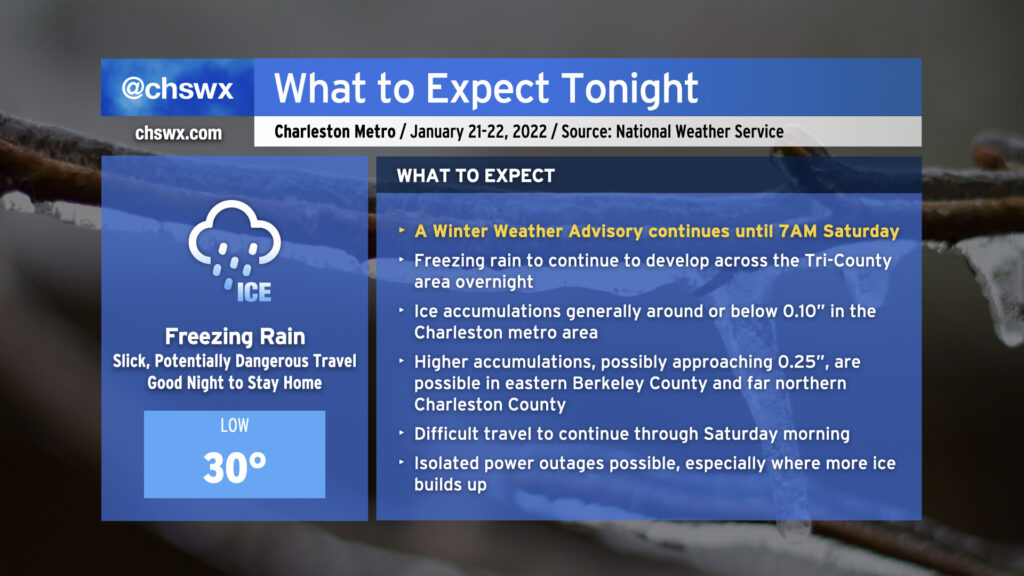
Freezing rain will continue overnight into early Saturday morning as moisture streams across the area from the southwest and a shallow layer of cold air continues to wedge southward into the area. As of this writing, temperatures are at freezing at all stations inland of the immediate coast, with reports of ice covering vehicles, elevated surfaces, and grassy surfaces starting to come in throughout the Tri-County.
Rain will continue to fall overnight, and as a result will continue to freeze on contact. At this point, it’s best to be where you’re going to be until tomorrow morning as ice buildup will continue. Most spots should see at or below a tenth of an inch of ice accretion before it’s all said and done; however, high-resolution guidance continues to suggest a little bit more accretion, possibly approaching 0.25″ in spots, in eastern Berkeley County and far northern Charleston County.
Travel will become increasingly difficult tonight, and the risk for isolated power outages will continue. Keep a flashlight nearby and your phones charged just in case.
Freezing rain is expected to be out of here by daybreak Saturday. Slick spots could persist into the late morning and early afternoon, though, as temperatures slowly warm to the low 40s with gradually decreasing cloud cover.
Here’s a little weather whiplash for you: We got to 73° today at the airport. Tomorrow, we won’t even reach 40°.
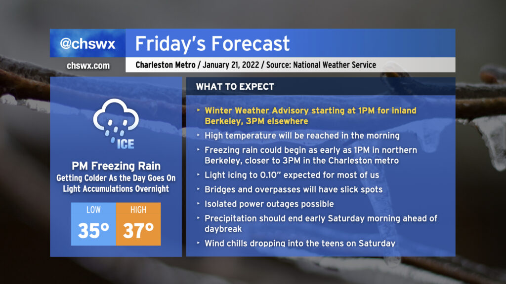
A cold front is sinking steadily southward in our direction this evening, which will allow a wedge of Arctic high pressure to steadily build in from the north as we get into Friday. We’ll start the day in the mid-30s, warm up to the upper 30s, and then temperatures fall below freezing in the afternoon, all while light rain blankets the area. As the freezing line moves southward, so will the changeover to freezing rain, generally on elevated surfaces (including bridges and overpasses.) This freezing rain threat will arrive by Friday evening and stick around through early Saturday before low pressure departs and brings the stalled front with it.
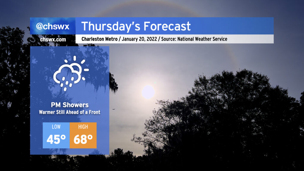
It’s going to be hard to believe that we’ll go from near 70° during the day Thursday to a winter storm come Friday, but that’s what’s going to happen. We’ll spend one last day in the warm sector as the cold front steadily pushes eastward; by afternoon, we should begin to see some showers work their way into the area ahead of said front. Rain will turn more likely as we get into the evening hours, so be ready for a wet commute home from work.
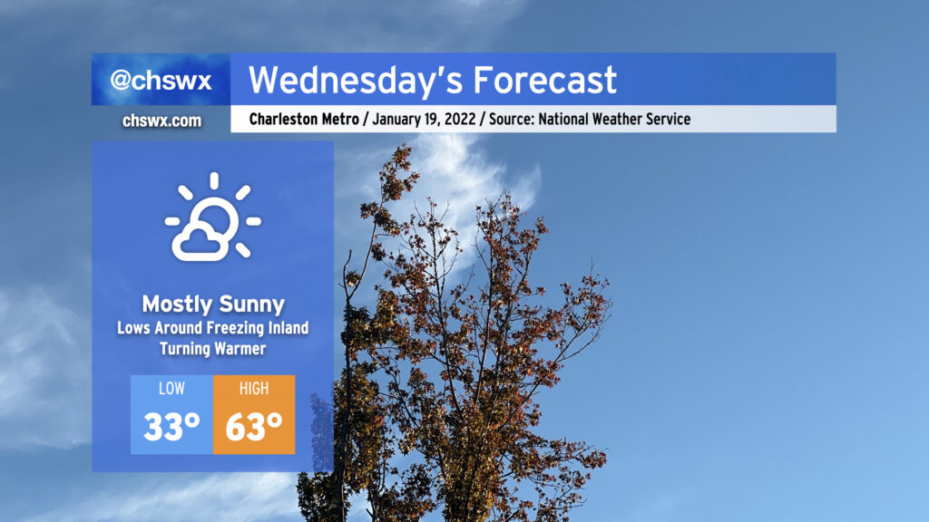
Wednesday’s weather looks pretty good. Temperatures will start out right around freezing — be sure pets and plants are protected once again tonight — with a nice warming trend up to the low 60s as high pressure slips offshore. All this will be under mostly sunny skies, with a few more clouds today than yesterday.
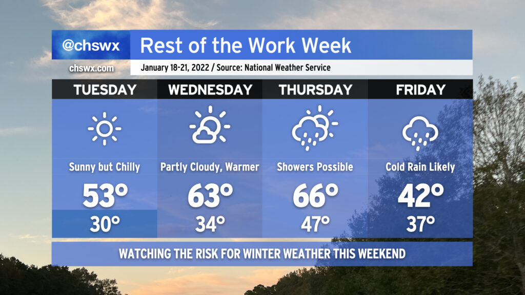
The temperature rollercoaster will continue as we head into the rest of this abbreviated (for some, anyway) work week. Tuesday will be sunny but still quite chilly as the cold airmass that this weekend’s storm ushered in stays put for another day. High pressure slips offshore Wednesday, though, allowing temperatures to warm up into the low 60s in the afternoon with a little bit more cloud cover working its way in ahead of a cold front. That front will get a little closer on Thursday and could begin to spread some showers into the area into the afternoon hours, but should stay far enough west to keep us in the 60s one more day.
Then Friday rolls around, and the wheels come off in terms of forecast confidence. What is probable is that the front will keep some precipitation around on Friday, and temperatures will be significantly cooler behind said front. The NWS forecast highlights rain showers and highs in the low 40s for Friday as cold high pressure wedges southward. Beyond that, the forecast turns very tricky. Weather models continue to disagree on many of the details of what to expect this weekend, but the potential for at least a little winter weather is increasing. The GFS model has a double-barreled shot of mixed precipitation for Friday night and again over the weekend as it has low pressure developing near the coast and moving northeastward. The ECMWF (Euro) operational model generally shows the primary winter weather threat in the form of freezing rain on Friday night into Saturday followed by dry weather the rest of the weekend.
Suffice to say, it’s a tricky, tricky forecast with more questions than answers at the moment. There are many scenarios, including an all-rain scenario, that are very much on the table. I urge you to continue to monitor forecast updates throughout the week as the details continue to come together, especially with the potential for freezing rain to develop.
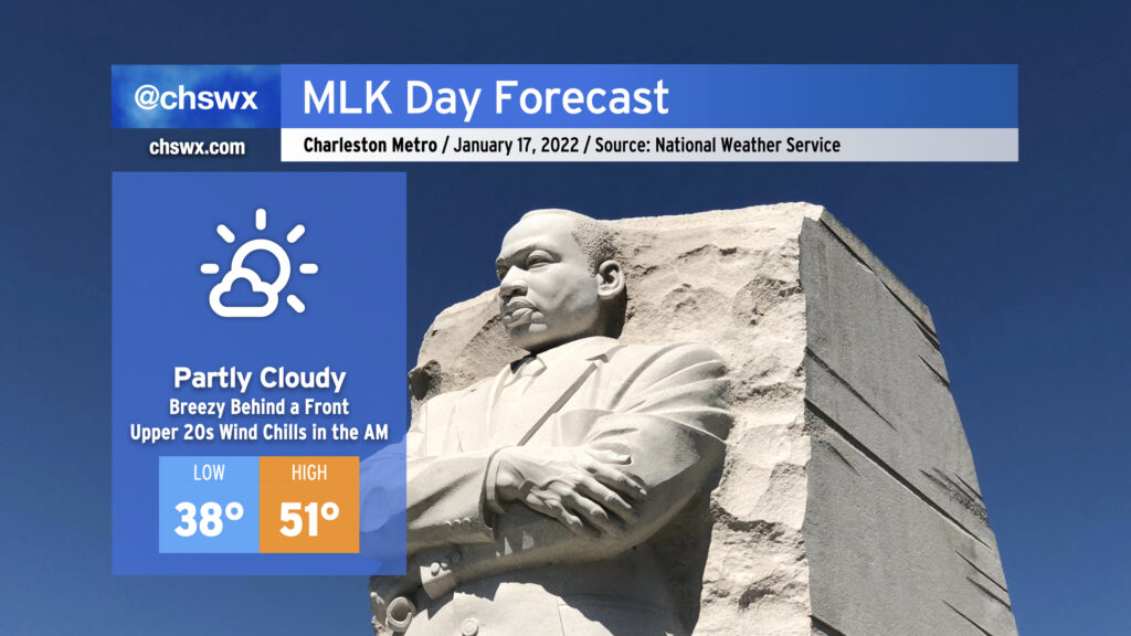
We’ll start Martin Luther King, Jr. Day out in chilly and breezy fashion as cold air moves into the area in the wake of today’s storm. Lows will bottom out generally in the mid-30s away from the coast, but gusty winds will make temperatures feel closer to the mid-to-upper 20s. A mix of clouds and sun will give way to fewer clouds and more sun by afternoon as high pressure continues to build back into the area. Despite the increasing sunshine, temperatures will still struggle into the low 50s as the colder airmass takes hold.