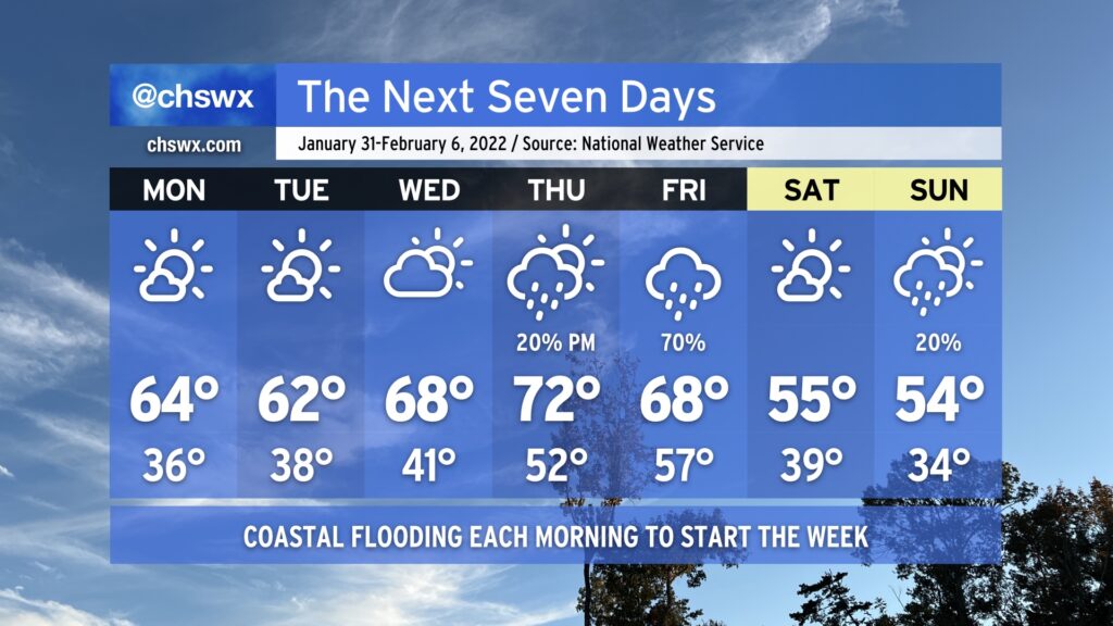
After a couple rather chilly weeks, we’ll give the heavy jackets a bit of a rest as ridging builds in aloft. We start the week with low temperatures in the mid-to-upper 30s and highs in the low-to-mid-60s with plenty of sunshine. Cloud cover ticks up a little bit for Wednesday, but so do temperatures as we get close to 70° in the afternoon. By Thursday, another storm system will be approaching from the west, but we should top out in the low 70s before it starts to get into the area. Right now our best rain chance arrives Friday as the cold front gets through. Saturday will turn much cooler with highs back in the mid-50s. This continues into Sunday, with perhaps a slight rain chance as moisture overruns a wedge of high pressure at the surface.
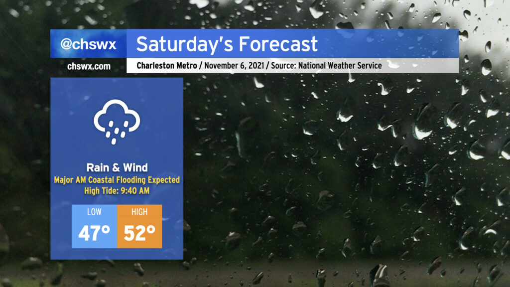
Saturday’s gonna be a meteorological mess, it appears. A coastal storm, which has been trending more westward in modeling, is expected to develop tonight and move parallel to the coast during the day Saturday. This is going to bring the potential for periods of heavy rain, gusty winds (with gusts 30-40 mph possible particularly near the coast), and a forecasted top-10 tide in Charleston Harbor during the morning hours.
High tide on Saturday morning is currently forecast to peak between 8.5-8.7′ in Charleston Harbor. This would be good enough for at least tenth on record at the harbor, and would be the highest tide since the water level reached 8.76′ on November 24, 2018. This will introduce significant salt water flooding across downtown Charleston, resulting in numerous road closures. It’s also possible that we will see road closures along Long Point Rd. in Mt. Pleasant and Harborview Rd. on James Island. The tide is forecast to peak at 9:40am, but with these events, there’s often a little lag, so it may peak later. Expect floodwater 2-3 hours either side of high tide.
Guidance continues to hit on the potential for rain to be in the area around this time of high tide, which could make the situation even more dicey. One other thing to keep in mind is that there will be a round of minor tidal flooding on Saturday evening, as well. Some simulated radar products bring some of the heaviest rain into the area Saturday afternoon, ahead of high tide. If it’s enough rain, we could be in for a long-duration flooding event. This will bear close watch throughout the day. The NWS forecast is generally for 2-3″ of rain across Charleston County, with somewhat lower amounts inland.
Finally, with the strong pressure gradient between developing low pressure to our east and high pressure to our northwest, winds will turn quite gusty at times. Gusts to 40 MPH appear possible on bridges and overpasses as well as the beaches. (It’s this strong northeast wind which will help drive water levels higher.)
Combine all this with highs in the low 50s, and well…you’ve got a perfect excuse to stay in on Saturday.
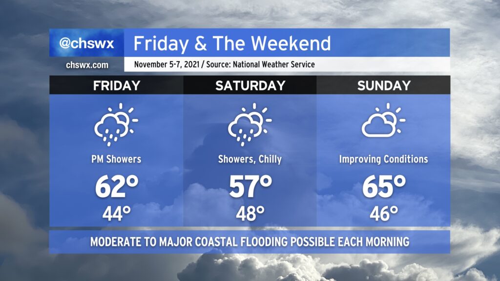
Much cooler than normal temperatures will persist for Friday into the weekend as a high pressure wedge remains in place, keeping north to northeasterly flow over the area through Sunday. As a coastal storm organizes offshore — how far offshore remains quite an important forecast question — we’ll see an uptick in rain chances beginning Friday evening into Saturday. Where the storm sets up will largely influence just how much rain we get, an important piece considering the specter of an 8’+ high tide on Saturday morning. If heavy rain coincides with that tide, what looks to already be a significant coastal flooding event gets that much worse.
The coastal storm will lift away from the area heading into Saturday night, and we should see some more sunshine on Sunday. Moderate to major flooding remains a threat with the Sunday morning high tide, though, and will need to be watched carefully. We’ll stay on the chilly side, too, with highs only topping out in the mid-60s — more January than November.
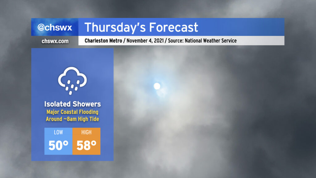
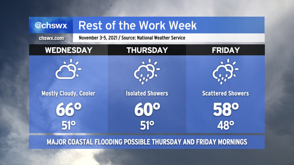
Thursday is going to have more of a mid-January feel to it as high pressure continues to wedge southward across the area, with breezy northeast winds, cloud cover, and maybe a shower or two helping to keep temperatures down into the 50s in the afternoon for the first time since early April. Suffice to say, it’s a sweater alert day across the Lowcountry!
The main weather-driven issue for Thursday, though, will be the risk for major coastal flooding around the morning high tide, which is forecast to peak between 8.0-8.2′ around 8am. If this water level verifies, it’ll close quite a few roads and make navigation around downtown Charleston unusually difficult. Salt water flooding could begin 2-3 hours ahead of the time of high tide, too, so be ready for some sporadic road closures even if your commute is on the early side. A Coastal Flood Watch is in effect for tomorrow morning between 5-11am. If the water level does look like it will approach 8′, the National Weather Service will upgrade this to a Coastal Flood Warning.
Another round of coastal flooding is expected with the evening high tide, which is predicted around 8:12pm and should peak around 7.3-7.4′. Minor to moderate flooding will be possible with this tide as well, though it won’t be nearly as widespread or severe as what is expected out of the morning high tide.
If there’s one bit of good news in all this, it’s that today’s tides underperformed guidance. This certainly is not a bellwether for lower-than-forecast water levels tomorrow, but it’s something to watch as forecasts for this event get calibrated over the next few days.
After a couple days of 70s and sunshine, cold air damming will begin to ooze into the area on Wednesday, kicking up cloud cover and keeping temperatures down into the mid-60s. It’s the first really good sweater weather day of the year, and the last fully rain-free day until Sunday. Thereafter, a storm system will affect our area from Thursday into the weekend. The wedge will remain intact through the rest of the work week, keeping gusty northeasterly winds — which could get as strong as gale force over the waters on Friday — in the area and cloud cover in place. Overrunning moisture will help contribute to a few showers on Thursday with more coverage Friday depending on where low pressure develops offshore. This, in turn, will help keep temperatures suppressed at or below 60° for Thursday and Friday. The last time we had a high below 60° was April 2nd, when the high topped out at a balmy 53°.
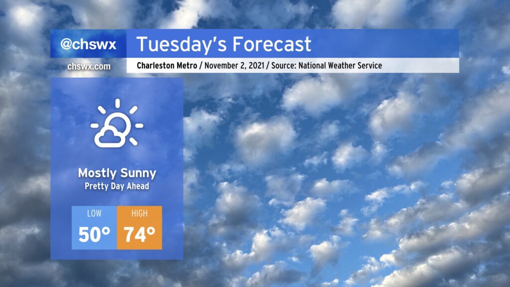
We’ve got one more really nice day on Tuesday before temperatures begin to fall back off into sweater weather territory. (Not that there’s anything wrong with that.) Expect highs to top out in the mid-70s after starting around 50° in the morning with mostly sunny skies throughout. We’ll begin to cool off after Tuesday as high pressure wedges southward into the area; highs don’t get out of the 60s on Wednesday and Thursday, and might not even crack 60° on Friday.
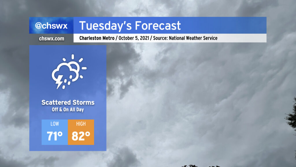
Scattered storms will enter the picture in earnest for Tuesday, perhaps as early as daybreak, as surface troughing combined with an upper low will provide the necessary ingredients for periods of rain tomorrow and for the next several days. Rainfall amounts should generally be light, but a few downpours within stronger storms cannot be ruled out. Temperatures will reflect the rather soggy atmosphere in place; lows won’t crack 70° in most spots and could bottom out in the mid-to-upper 70s at downtown, while highs won’t top out too far above 80° given expected cloud cover and rainfall in the area.
No severe weather is expected, but we will want to watch for the potential for some salt water flooding around the 7:52 PM high tide as astronomical effects combine with onshore flow to raise water levels in the harbor. The 7:35 AM high tide, which is forecast to fall short of coastal flood stage, will still bear a little watching in case a downpour develops near Downtown around that time, but the flood probability in the morning is generally low.
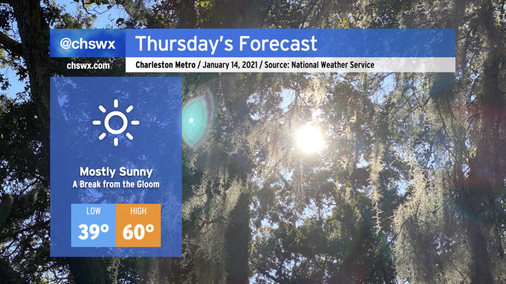
After a stubborn cloud deck kept temperatures significantly lower than expected today, we will finally get these clouds out of here once and for all and enjoy a mostly sunny day on Thursday. Highs will top out around 60° in most spots. It’ll sure feel nice to get this gloomy stuff out of here, that’s for sure.
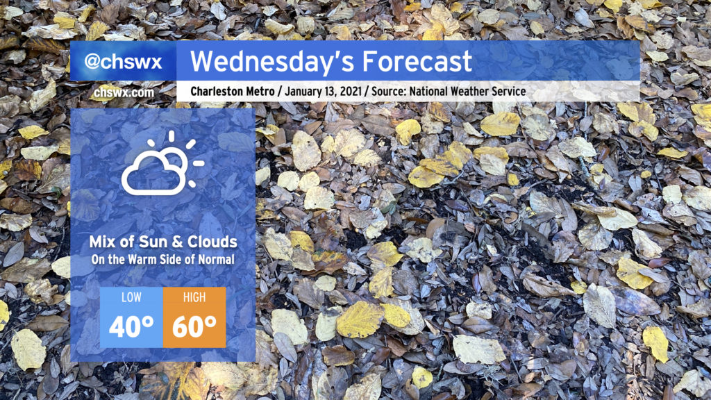
We’ll warm up a bit on Wednesday as a little more sun works into the area with high pressure at the surface. Cloud cover will be reinforced at times by some upper-level energy moving through the area, but despite that, we should touch 60° in the afternoon, which is right on the warm side of a normal high temperature for mid-January.
Watch for patches of fog in the morning causing dips in visibility at times. Fog should mix out by 9am, giving way to the aforementioned partly sunny skies.
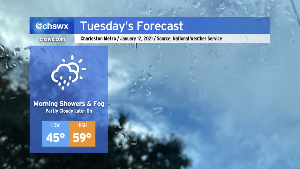
As low pressure moves eastward along the Gulf coast, we’ll keep the risk of showers and drizzle around through early Tuesday afternoon before high pressure begins to build in and cloud cover slowly breaks. Watch for areas of fog in the morning; be sure to use low beams and be prepared for visibility to drop quickly.
We should see a little sun before Tuesday’s gone, and there will be much more where that comes from as we get into the rest of the week. Temperatures could top out in the upper 50s, but this certainly will be dependent on how quickly the cloud deck can scour out.