Wednesday will likely represent the last really decent weather day across the Lowcountry before winds begin to turn much more breezy as Ian approaches the area starting Thursday. (A Tropical Storm Warning is now in effect, too.) It’ll be a good day to bring things in from outdoors, check on your batteries, flashlights, and weather radios, and if in a flood-prone area, sandbag property appropriately if needed. We’re in for what might be a tricky few days…but it’s nothing we won’t be able to handle, either.
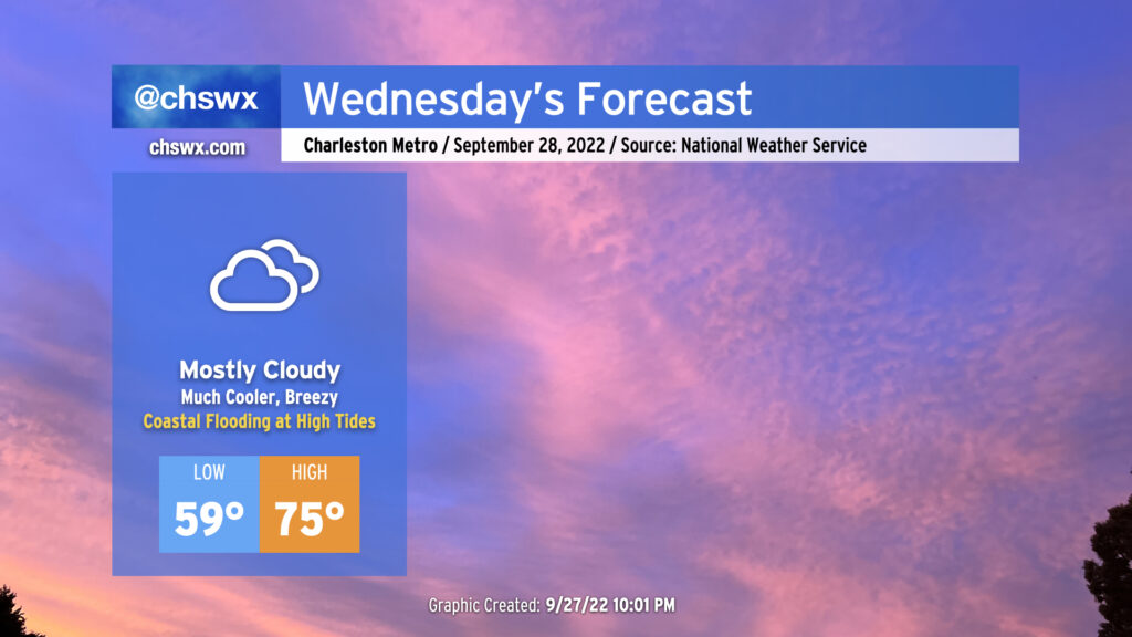
It’s gonna feel a lot cooler Wednesday, that’s for sure, as high pressure builds in from the north. Winds will turn northeasterly and be gusty at times, with gusts around 25-30 MPH possible, higher closer to the coast. Temperatures will start out in the upper 50s and stay cool, with mid-70s at best with thickening cloud cover ahead of Ian blanketing the skies. We stay rain-free thanks to a deep layer of dry air closer to the surface, however.
Minor coastal flooding will be a concern with the 10:07am and 10:17pm high tides as the northeasterly flow around high pressure to the north drives water levels higher. This could be enough to close a couple roads in the more vulnerable areas, such as around Gadsden Creek. Major disruptions to travel aren’t anticipated, however.
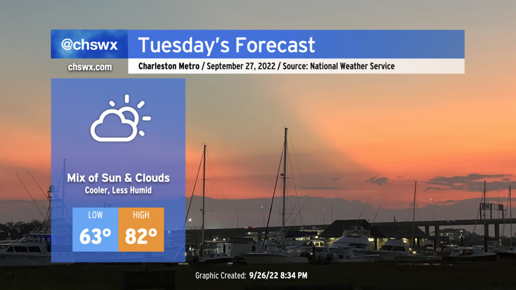
We’ll turn cooler tomorrow as a front gets through tonight. Expect lows to run a few degrees lower in the mid-60s (a touch warmer near the coast where water temperatures still hover around 80°). Highs will get to the low 80s under a mix of clouds and sun as high pressure wedges in from the northeast. It’ll be a good day to get prep work done ahead of Ian, which continues to look to produce impacts in the Lowcountry later this week.
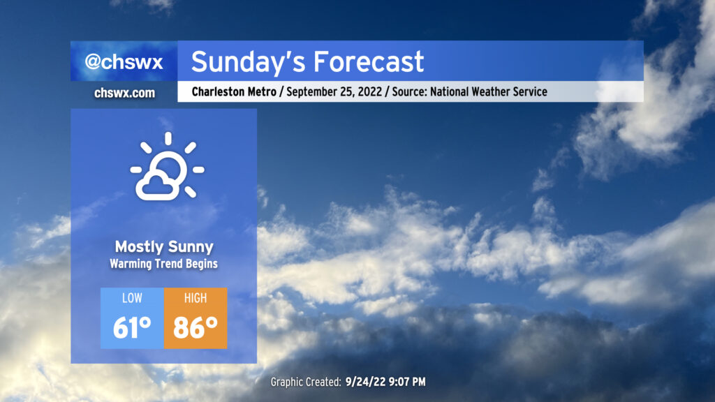
We’ve got another nice-looking day of weather coming up for Sunday. We start the day a little warmer than we did Saturday — lows generally around 60° away from the locally warmer coast — but it’ll still feel nice and fall-like to start the day. High temperatures will head up into the mid-80s in the afternoon under mostly sunny skies; southwesterly winds will bring a little more in the way of humidity into the picture as well, but dewpoints in the mid-60s will still feel alright.
Sunday marks the beginning of a brief warming trend that’ll see us head into the upper 80s on Monday ahead of another cold front. That front should pass with minimal fanfare, though a shower or two can’t be totally ruled out Monday evening. This will set us up for a nice day of weather on Tuesday, with highs in the low 80s expected.
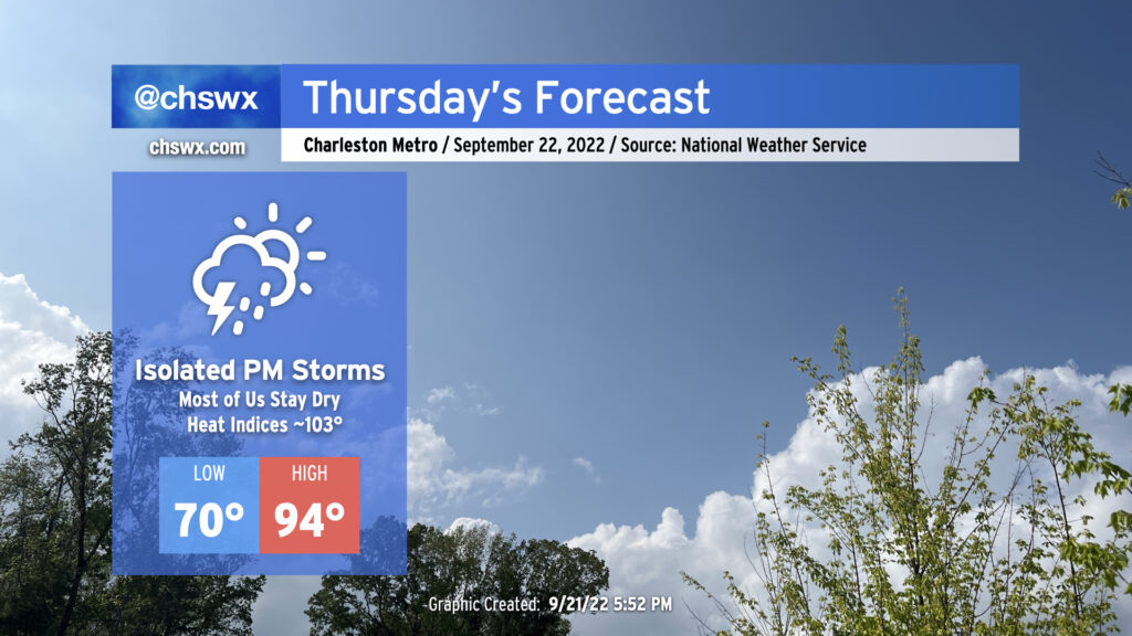
We’ve got one more hot day in store for Thursday before the weather takes a turn for the fantastic for Friday and the weekend. Compressional heating ahead of a cold front will drive highs into the mid-90s for Thursday afternoon, perhaps approaching the record high of 96° set in 1990 at the airport. Downtown could very well tie or break the record high of 92° set in 1925, too. Mix in a little bit of humidity and it’ll feel closer to the upper 90s (though heat indices should stay south of 100° as the deep-layer dry air helps to mix out dewpoints to the mid-60s). There will be a slight chance of showers and thunderstorms in the late afternoon and early evening hours as the front passes by, but don’t expect anything too heinous as there’s still plenty of dry air to overcome for much in the way of active weather.
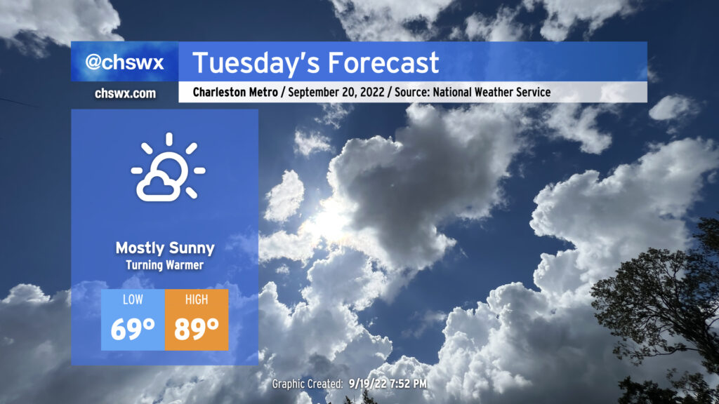
Tuesday will kick off a period of quiet and warming weather as expansive high pressure at the surface and aloft builds into the region from the west. This’ll put the lid on much in the way of cloud cover, much less thunderstorm activity, allowing temperatures to approach 90° in the afternoon. Humidity won’t be terribly heinous, but will be enough to push the heat index to around 92° or so. Temperatures, especially highs, will run several degrees above normal through Thursday (which could approach the mid-90s) before a trough digs in to our north and drives a cold front through, which will make for a rather pleasant Friday and weekend of weather. (Not that I’m counting down or anything.)
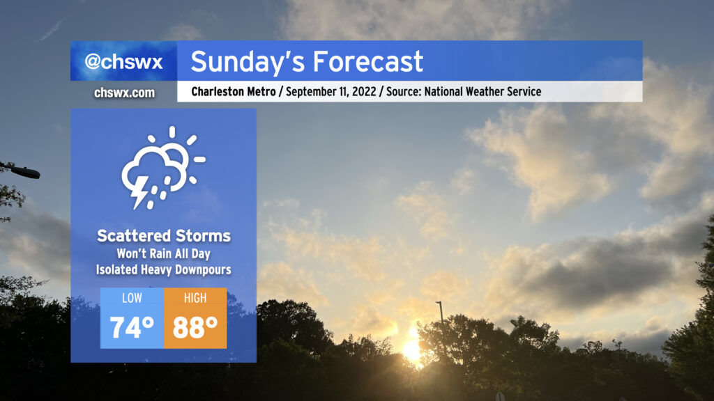
A coastal trough will bring our first mentionable shower and storm chances in a few days for Sunday as a few showers and thunderstorms could drift ashore from time to time. While some of the high-resolution guidance has been awfully aggressive about rainfall amounts and how far inland measurable rain gets, generally expect the best chance for any showers toward the coast. An isolated downpour can’t be ruled out particularly if deeper moisture can make it ashore. With all that said, the rain chances are far from substantial enough for canceling any outdoor plans — just keep an eye out tomorrow in the unlikely event a storm approaches.
Temperatures will continue to run right around normal for this point in the year. We’ll start the day in the mid-to-upper 60s across much of the metro (low 70s at the beaches) before temperatures head up to the mid-80s in the afternoon. Dewpoints are forecast to approach 70° in the afternoon, and that’ll yield heat indices in the low 90s at peak heating.
We’ll see similar conditions on Monday before a ridge of high pressure asserts control at the surface and aloft. We’ve got a few hot days in store next week, with air temperatures in the low 90s possible mid-week as we reach the autumnal equinox and Fall begins. A dry front will usher in a shot of cooler and drier air just in time for the weekend, though. NWS’s opening bid for next Saturday: Low 66°, high 81°, mostly sunny skies, dewpoints in the low 60s. (Can we fast-forward?)
We’ve got a really nice weather day coming up for Thursday. We’ll start the day in the mid-60s away from the coast (where the warmer water temperatures will keep lows above 70°). Temperatures will head into the mid-80s under mostly sunny skies with a northeasterly breeze keeping things feeling seasonable. Meanwhile, dewpoints will mix out to around 60°, making for a very comfortable afternoon. All in all, it should be a really nice day to get out and about a bit as you can — I’d certainly recommend it.
Pleasant weather will continue for Friday into the weekend, too. A coastal trough could help get a shower or two toward the area on Saturday and Sunday, but otherwise, expect rain-free conditions and seasonable temperatures.
Ready for a break in the humidity? If so — as I suspect most of you are — it begins on Tuesday as drier air filters into the area throughout the day. We’ll see dewpoints fall from the low 70s to start the day to the mid-60s by sundown. High temperatures will still top out in the upper 80s, and it’ll still feel a little more like 90-91°, but overall, it’ll start to feel a lot better. There’s a small chance for a few showers to fire near the coast in the late afternoon, but the vast majority of us look to stay rain-free under partly cloudy skies.
It gets better from here, too: Wednesday morning will feel positively refreshing with dewpoints in the low 60s and air temperatures in the mid-60s away from the coast. It’ll also be the first day with zeroed-out rain chances all month. Should be an excellent day for an outdoor lunch or an evening walk. (Why not both?)
Rain chances within onshore flow creep up a bit starting Thursday as a coastal trough forms, but temperatures will remain a little more seasonable — not quite fall, but not quite blazing summer, either, as highs top out in the low 80s after morning lows in the upper 60s.
Expect another round of scattered showers and thunderstorms for Sunday as moisture continues to pump into the area from the Gulf and beyond. We may see some pre-sunrise showers and storms in the area to start the day, but the greater probability of precipitation will arrive in the afternoon as the seabreeze begins trekking inland and thunderstorms get rolling. Heavy rain and lightning will be the main concerns for any thunderstorm that develops. Once again, don’t expect it to rain all day at any one location — just be ready to move outdoor activities inside if thunderstorms approach.
Given the scattered cloud cover, expect temperatures to head into the upper 80s in the afternoon. Mix in the humidity, though, and it’ll feel closer to 100-102°. Given just how much rain has fallen in the last few days, too, grassy areas without much tree cover may be especially heinous.
Elevated rain chances continue for Monday, but we will start to see a bit calmer weather Tuesday and especially Wednesday before a front stalls out nearby Thursday, which will bring some scattered rain chances back into the picture — though right now, it looks nothing like we’ve been experiencing recently.
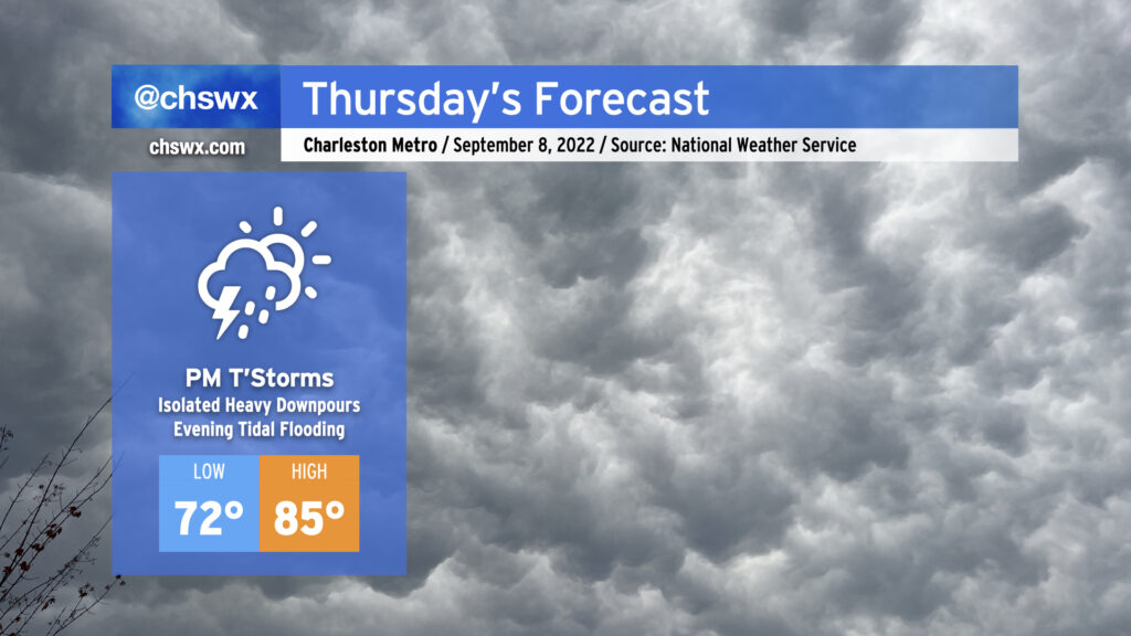
We transition back to a more active pattern beginning Thursday as a front gets through and stalls out nearby while the upper-air configuration aims a steady stream of moisture and disturbances at us for a few days. While it looks like we start the day mostly dry, expect showers and storms to develop in the afternoon and evening hours. Rain will be locally heavy at times, with the potential for isolated bouts of freshwater flooding. The increase in cloud cover and shower activity will help limit highs to the mid-80s, some 10° cooler than we’ve experienced the past couple days.
Tides will begin running well into flood stage in Charleston Harbor around the evening high tides beginning Thursday. Minor to moderate flooding is forecast Thursday evening around the 7:22 PM high tide, and this should be enough to close a few roads downtown regardless of any rain. If it rains heavily, of course, this will certainly lead to a more widespread flooding event, so we’ll be watching downtown closely on Thursday and over the next few evenings in general.
Rain chances continue to head up Friday into the weekend as precipitable water values surge well past 2″. The risk for flooding will increase accordingly across the area, and mixing in the higher tides, we could be in for a busy few days downtown. Stay tuned to forecast updates as we close out the work week and head into the weekend.