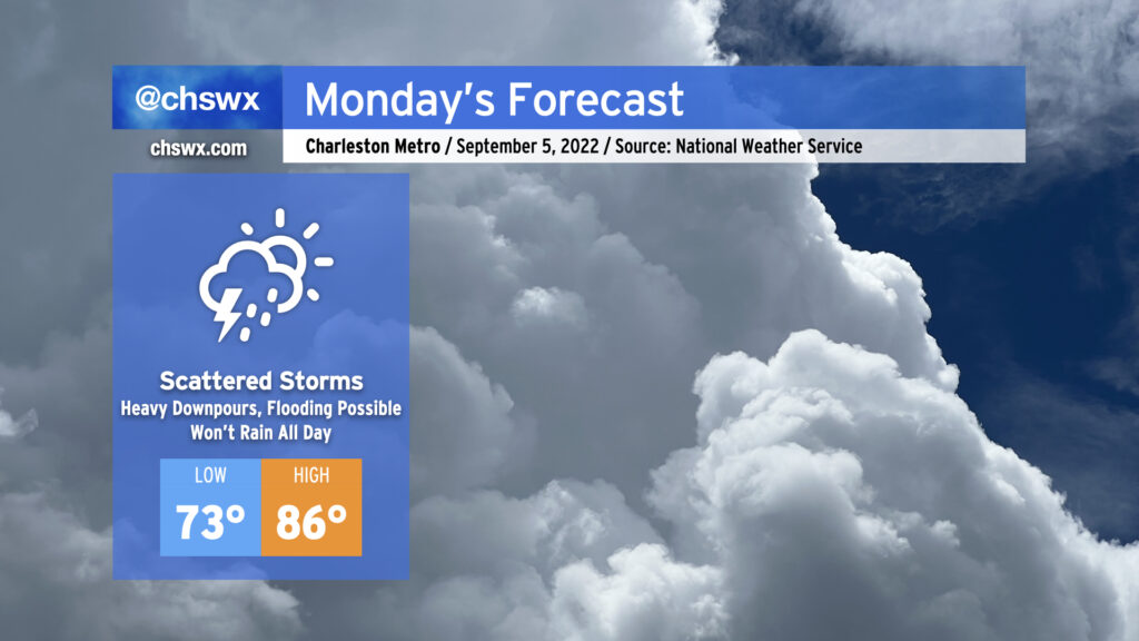
Labor Day looks to feature an uptick in shower and storm coverage when compared to Sunday’s relatively quiet weather, but it still doesn’t look like a situation where outdoor plans will be totally washed out. After a little drier air worked its way into the area for Sunday, more moisture will move back in from the southwest for Monday. We could start the day with some showers and storms advancing northeastward across the area with some brief downpours embedded. Then, the seabreeze should kick in during the afternoon and help develop more showers and thunderstorms, which will progress inland with time. Heavy rain is the main concern from any thunderstorms; with precipitable water values over 2″, there will be a risk for flooding in a few spots where heavy rain repeats on itself. Of course, lightning will be a concern as well — as always, remember that if you’re hearing thunder, you’re in the strike zone. When thunder roars, go indoors!
Like the last few mornings, we’ll start in the low-to-mid 70s (warmer near the coast) and head toward the mid-80s in the afternoon outside of any showers and thunderstorms that develop. Mix in the humidity and it’ll feel closer to some very muggy mid-90s.
Bottom line: It won’t rain all day, but you’ll want to keep an eye to the sky in case conditions begin to head downhill. Be flexible with your outdoor plans and have a solid plan B in your back pocket.
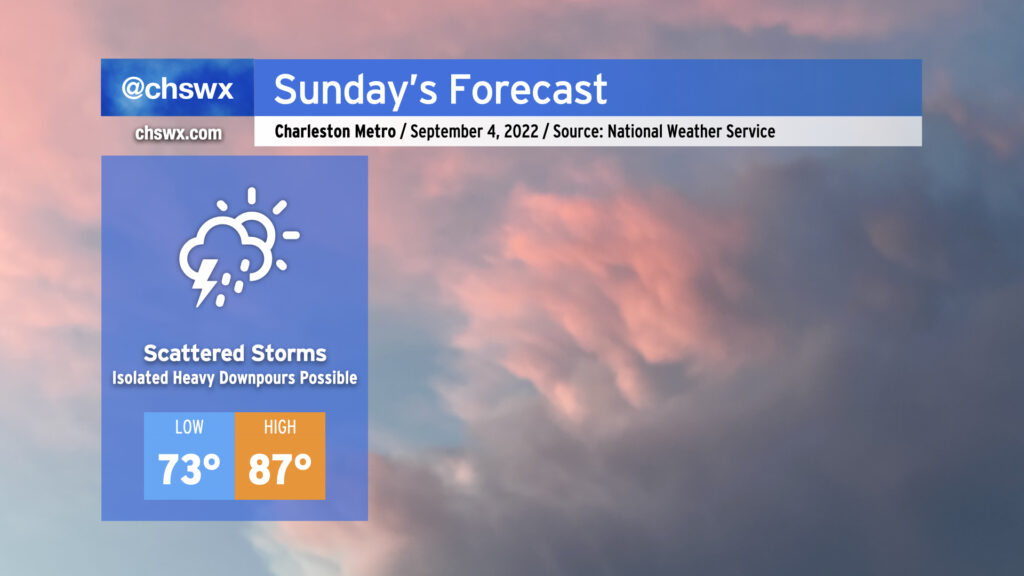
Sunday’s forecast is essentially a matter of highlighting today’s weather, hitting Cmd+C, then Cmd+V (or Ctrl if you’re on Windows or Linux). Onshore flow will continue with the risk for scattered showers and storms throughout the day. Better rain chances will be found at the coast in the morning before transitioning inland with the seabreeze in the afternoon. Precipitable water values will remain at or above 2″, which will promote the risk for isolated downpours and perhaps flooding concerns if heavy rain ends up repeating over the same area. The diffuse stationary front which has been plaguing our surface pattern for the better part of a week now will wobble a little further southwest for Sunday, which should keep the more widespread rainfall in Georgia. Even still, though, stay flexible with your outdoor plans and be ready to move them inside quickly if storms approach.
Temperatures will once again follow today’s trend: lows in the low-to-mid-70s to start the day, with highs topping out in the mid-to-upper 80s before showers and thunderstorms set in. Heat indices will run in the mid-90s with the continued summer-esque humidity in place.
This pattern looks to continue into Labor Day and beyond. Aloft, ridging remains firmly in place over the next several days as an upper low cuts off over the Midwest. In the tropics, Tropical Storm Earl, which was named last night, will recurve well away from the US before it becomes a threat to land, while Danielle remains very far out in the Atlantic, an issue for shipping traffic and fish.
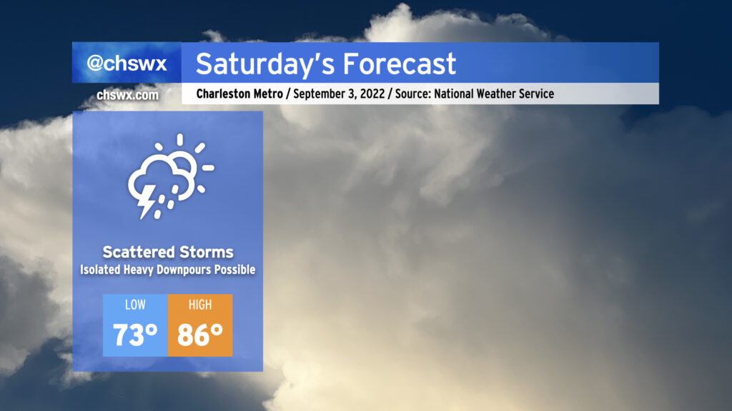
Saturday looks to bring another round of scattered showers and storms to the area, possibly as soon as sun-up as storms develop offshore and drift inland within onshore flow. During the day Saturday, a stationary front could wobble back north into the area, which may help focus additional shower and storm development in the afternoon. Unfortunately, the models are still varying quite widely on precipitation coverage during the afternoon and evening hours, so it’s going to be difficult to pinpoint exactly when and where it will rain until trends become apparent tomorrow. With that in mind, I don’t think it is wise to totally shelve outdoor plans, but I would recommend having a strong backup plan in your back pocket ready to go.
Thanks to onshore flow, lows on Saturday will run a couple clicks above normal (low to mid-70s) and highs will run a couple clicks below normal, generally running in the mid-80s in the afternoon ahead of any showers or thunderstorms that may develop. Mix in humidity and it’ll feel like the mid-90s.
We look to stay in this pattern through the Labor Day holiday, with variable rain chances each day driven largely by the positioning of the stalled front and the state of the atmosphere after any convection on the previous day. My advice remains the same: Don’t cancel plans, but be ready to change them.
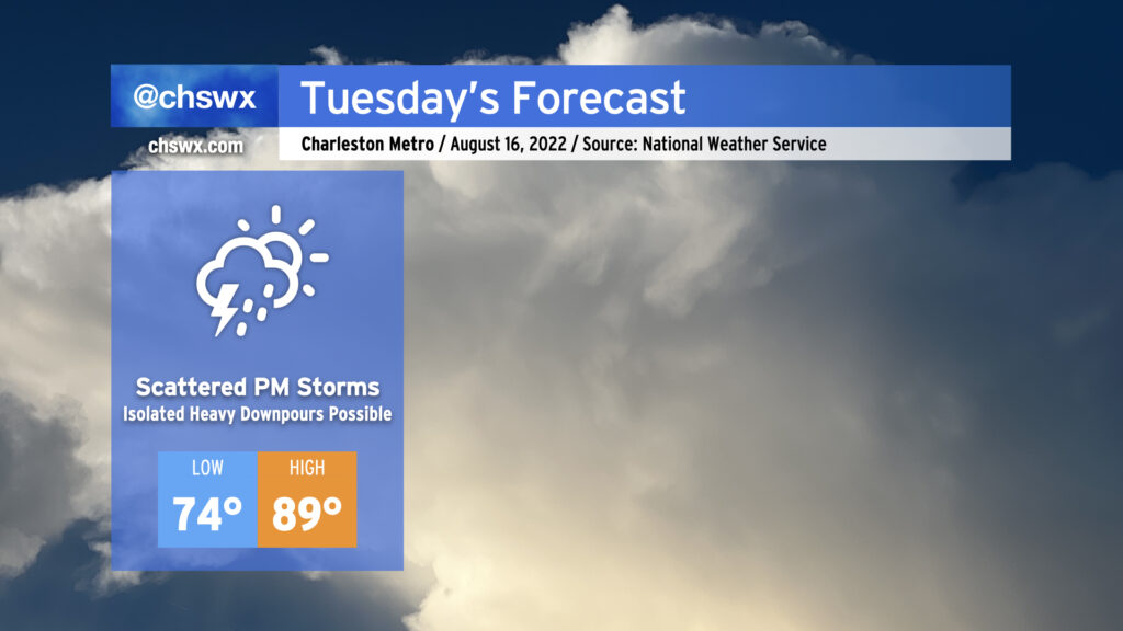
After a torrential deluge that closed numerous streets both in downtown Charleston as well as North Charleston, we should see a little less coverage of showers and thunderstorms for Tuesday, but more heavy rainfall will be possible. We could once again see some wet weather for tomorrow morning’s commute as another round of showers and storms skirts up the coast. Then, a more typical afternoon round of scattered showers and storms should fire up along the seabreeze as temperatures are expected to climb to the mid-to-upper 80s. Given the drenched soils from Monday’s rains, it may not take much to cause additional flooding problems on Tuesday where heavier rain falls, so that’ll certainly be something worth watching. Flooding rain, though, should certainly not be as widespread as we saw today.
We’ll continue to see a decrease in coverage as the week goes on, though scattered showers and storms will remain possible each afternoon, with a few stronger storms not out of the question Wednesday into Thursday. An uptick in coverage is possible Friday into Saturday depending on where a cold front stalls out — stay tuned for refinements.
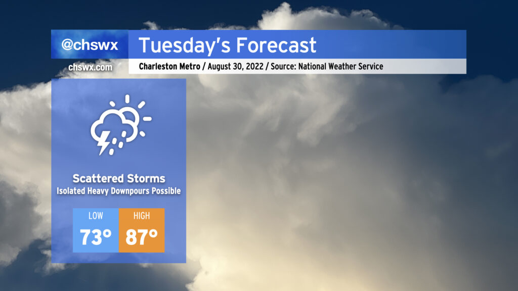
Tuesday will begin a stretch of unsettled days across the Lowcountry as a cold front moves into the area and stalls out. This will help kick off showers and thunderstorms in the afternoon, with some heavy rain possible at times in the strongest storms. There are some indications in the high-resolution ensemble guidance that we could see heavy rain near the coast later in the evening as the boundary approaches; fortunately, we’ll be heading toward low tide during commute time. That being said, be ready for a little longer drive home.
Highs will top out near 90° before the onset of showers and thunderstorms; mix in low 70s dewpoints and it’ll feel around 95-97°. This is right around normal for mid-August.
Wednesday could run a little cooler and a little drier as the front could sag south of the area briefly before meandering back northward on Thursday. Likely rain chances will continue through the end of the work week into the weekend.
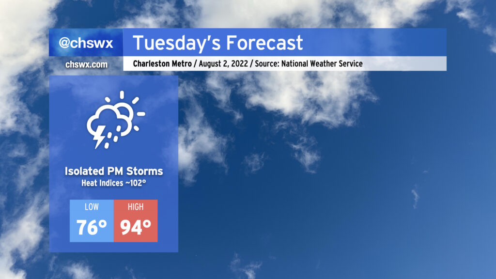
More warm and humid weather is on tap for Tuesday as air temperatures once again peak in the mid-90s after starting out in the mid-70s away from the warmer coastline. Mix in humidity and it’ll feel closer to the low 100s, especially as the seabreeze passes by in the afternoon. Rain-wise, it looks to be a fairly typical summer day. We could contend with a few showers in the morning near the coast, with primarily seabreeze-driven isolated shower and storm coverage in the afternoon. Storms will be able to produce some heavy rain and maybe a few strong wind gusts, but severe weather isn’t anticipated.
We could see a little better storm coverage on Wednesday before high pressure rebuilds later in the week. Temperatures will be trending down toward around normal for this point in the year as well, with highs around 90° each day from Thursday into next week.
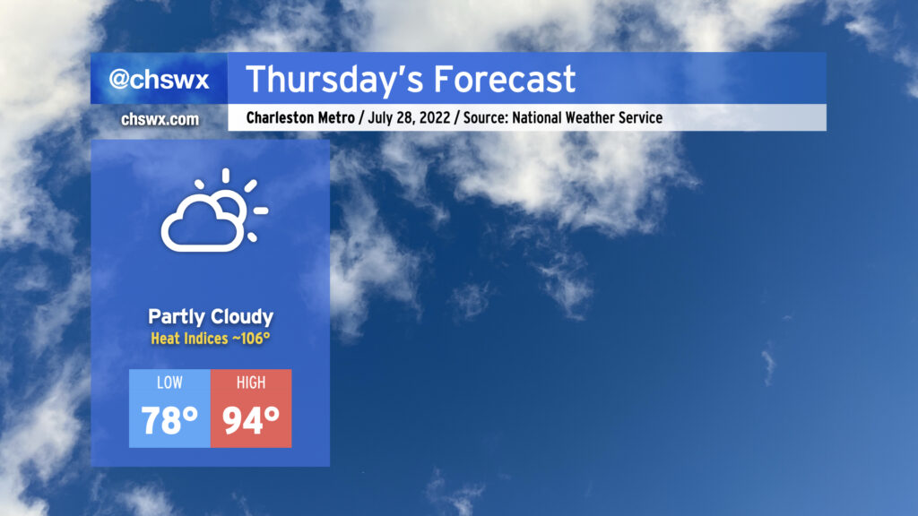
Another hot day is in store Thursday. After starting in the upper 70s away from the coast and Downtown (lower 80s there, gross), temperatures will warm to the mid-90s in the afternoon under partly cloudy skies. Mix in humidity and that’ll yield heat indices around 106°, plenty warm enough for heat exhaustion concerns during the peak of the afternoon. Much like today, expect rain-free conditions to persist as high pressure and the surface and aloft keep thunderstorm development at bay. Indeed, the only relief may be a cumulus cloud or two blocking out a bit of sun for a time.
We saw a lot less rainfall across the area today as ridging began to take hold. This continues into tomorrow and for much of the rest of the week as high pressure strengthens and maintains its grip. Highs will top out in the low 90s; mix in some humidity and you’ve got yourself heat indices in the low 100s.
Rain-wise, there’s not too much to write home about: We’ll have a shot at a shower or storm or two in the morning along the coast, but much of that activity should remain largely offshore. An isolated storm or two cannot be totally ruled out in the afternoon; where a storm fires, the rain could turn heavy and winds could be briefly gusty. However, the vast majority of us should stay dry. Expect this pattern to largely repeat itself for the rest of the work week, too, just with warmer air temperatures contributing to heat indices eventually reaching 105-110° by Wednesday and Thursday.
We’ve got another warm, steamy day ahead on Thursday with the potential for heavy afternoon thunderstorms once again affecting the area. Temperatures will start in the mid-70s once again, and your glasses (sun or otherwise) will almost certainly fog up when you walk outside in the morning. Temperatures should rise to the low 90s by early afternoon, and when you factor in the humidity, it’ll feel closer to 105-106° or so — certainly stifling heat that’ll require precautions against heat exhaustion or heat stroke if you must be outside tomorrow afternoon.
Attention will then turn to the threat for showers and thunderstorms. The seabreeze may once again be the culprit for at least an initial round of storms, while west-northwest flow aloft will be monitored closely for any thunderstorm complexes that can develop and push our direction. The seabreeze should have an easier time moving inland tomorrow than it did today, but it could still face some resistance and stay pinned closer to the coast. We’ll want to watch the seabreeze’s inland progression carefully; the lack of such progression today, with storms firing along it and then training heavy rain in the same places, led to 2″ of rain in a little over an hour in spots and resulted in yet another urban flooding event in downtown Charleston. If storms get going, they’ll have plenty of moisture to work with, as precipitable water values continue to be in the 2-2.2″+ range. Hopefully we won’t see a repeat of today — odds are, we won’t — but we’ll keep an eye on it regardless.
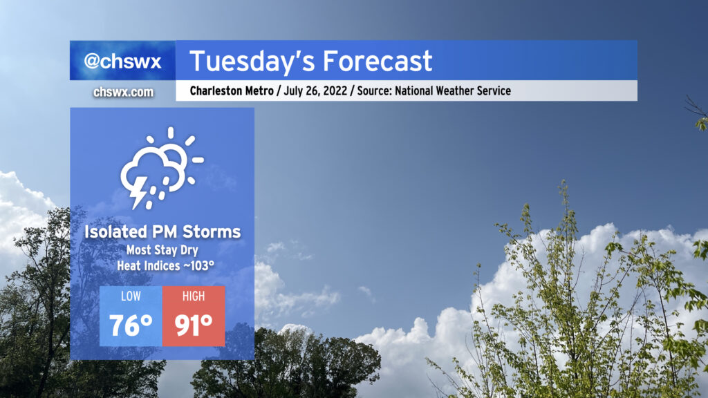
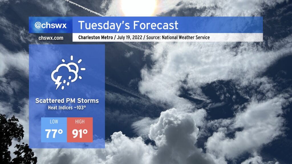
Tuesday will be another steamy July day in the Lowcountry. We’ll start the day in the mid-to-upper 70s in much of the metro area, while the beaches and downtown may very well not get below 80°. Highs will climb into the low 90s; mix in the humidity and it’ll feel closer to the low 100s. Unlike the past few days, showers and thunderstorms should hold off until the afternoon. As always, a strong storm or two can’t totally be ruled out, with wet microbursts a possibility. More broadly, though, heavy rain will be possible as precipitable water values remain around 2”, and ample amounts of energy will be conducive to lightning-laden storms.
We’ll stay in the 90s for much of the rest of the week, with heat indices approaching 105° at times. Scattered afternoon showers and storms will be the rule, with perhaps a little uptick in activity heading toward Friday as a front approaches the area.