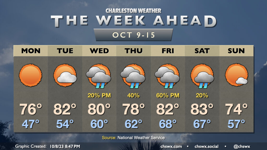
After a day that featured lows in the low 50s and highs topping out just in the low 70s, clear skies and calm winds will allow temperatures across much of the metro area (inland of the coast, anyway) to fall into the 40s for the first time since early May on Monday morning. Sunny skies will prevail throughout the day, and temperatures should reach the mid-70s in the afternoon as a result. Overall, it will be another really nice day across the Lowcountry.
The chill will gradually recede as high pressure shifts offshore during the day Monday. Tuesday will run warmer and a little cloudier, with highs topping out in the low 80s in the afternoon after a mid-50s start. A little more cloud cover works into the area by Wednesday as a jet streak strengthens overhead, which should lead to a few showers later in the day (though there’s a lot of dry air to overcome initially). Shower chances improve into Thursday as low pressure moves eastward out of the Gulf of Mexico. We should see an uptick in cloud cover and a little cooler day as well as high pressure wedges in from the northeast. We’ll stay wedged in for a good bit of Friday, though a warm front should lift northward later in the day. Shower chances will continue and perhaps tick up a bit as the aforementioned warm front gets nearby. A little thunder will be possible, too.
Conditions should gradually improve over the weekend as a cold front gets through late on Saturday, and by Sunday, temperatures head back below normal into the mid-70s under mostly sunny skies. (Frontal timing, of course, will be fine-tuned as the week goes on.)
A blocking pattern aloft will keep our weather relatively quiet for much of the week before a front approaches heading into the weekend, which might deliver the first real shot of fall weather to the area for early next week.
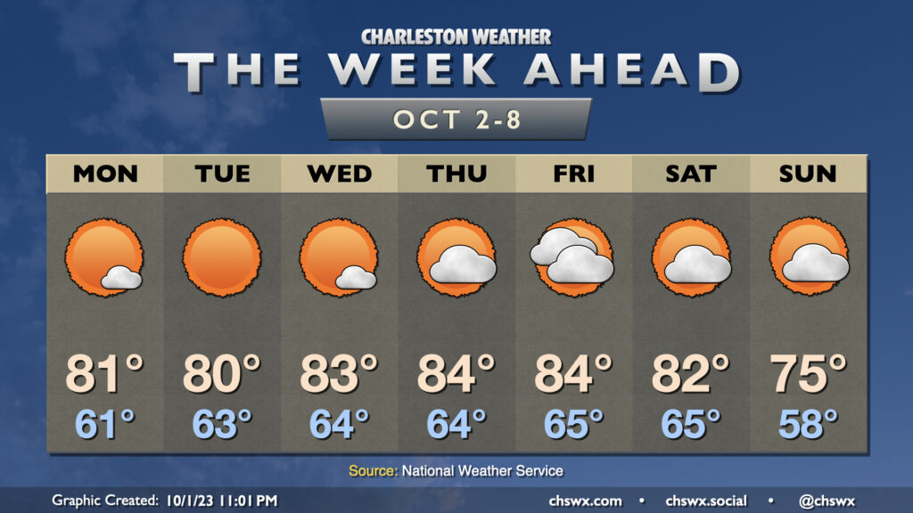
Cloud cover will generally be sparse through Wednesday as high pressure remains firmly in control across the area. Our mornings will generally start in the low to mid-60s with highs topping out in the low 80s each afternoon with plenty of sunshine to be had. Cloud cover begins to tick up a bit for Thursday into Friday as the aforementioned front begins to approach the area. It remains to be seen just how much moisture moves back into the area; for now, the forecast remains rain-free, though it wouldn’t shock me to see some shower or thunderstorm chances added as we head into Friday. Saturday should feature decreasing clouds, and then it looks like a reinforcing shot of cooler air moves in for Sunday that could knock temperatures well below normal for this point in the year. We aren’t into sweater weather yet, but we’re making progress!
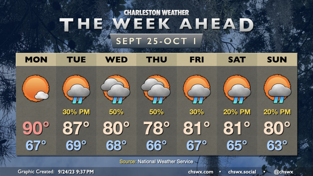
We may be past the autumnal equinox, but Monday clearly looks to have missed the memo as it brings back a bit of summer before temperatures fall back below normal later this week. Dry air will keep skies mostly clear, and a bit of shortwave ridging will help highs top out around 90° in the afternoon after starting the day in the upper 60s to around 70° at the coast. From there, though, changes will be afoot as high pressure anchored in New England starts to wedge into the area beginning Tuesday. This will drive high temperatures from the mid-80s on Tuesday to the low 80s by Wednesday, with below-normal highs lasting into the weekend. A trough developing offshore will help keep shower chances in play for much of the week, primarily in the afternoons, though it’s worth noting that we’ll likely get some sunshine in as well at times. Northeasterly winds will turn breezy as we head into the second part of the week, and this could drive some coastal flooding concerns through the weekend. Some of the guidance is spitting out some fairly high tides, but it’s also worth noting that this guidance isn’t really that awesome and often goes to extremes. Keep an ear out for Coastal Flood Advisories from the National Weather Service.
After an incredibly soggy day across the Charleston metro, featuring another round of downtown flooding and rain totals exceeding 4″ in some spots, we get a couple days to dry out to start the work week. We start Monday in the mid-to-upper 60s and top out in the mid-80s as dewpoints fall into the low 60s throughout the day, which will make it an awfully nice day for an emotional support lunch outdoors as we head back to work. We keep the vibe going into Tuesday, with a somewhat cooler start thanks to the lower dewpoints in the area. A few more clouds are expected, but otherwise expect another nice day. Winds go northeasterly on Wednesday and could bring a few showers or storms into the area, but otherwise, much of us should stay rain-free.
Things get weird starting Thursday and heading into the weekend. Models are in good agreement that low pressure will spin up nearby in something resembling more of a nor’easter setup than anything else. However, if it stays over water (which is still plenty warm), there’s a chance it could try to acquire some tropical characteristics. Right now, the forecast is for some periods of rain and some gusty winds particularly near the beaches, and regardless of whether the storm is cold-core, warm-core, or hybrid, the impacts should be relatively straightforward. Obviously, we’ll keep an eye on this, but for now, not seeing anything extraordinary here. Stay tuned to forecast updates in the meantime.
We will get off to a warm start for the first part of the work week, but a front will bring another taste of fall for the second half into the weekend.
Much of the weather scuttlebutt this week will be about Tropical Storm Idalia, which increasingly looks like it’s going to have impacts on the area Wednesday into Thursday. We have a couple reasonably quiet days ahead before the weather begins to head downhill later Tuesday night. Expect highs on Monday to top out in the low 90s with just a slight chance of an afternoon shower or thunderstorm along the seabreeze; it’ll be a similar story for a good bit of Tuesday before moisture from Idalia potentially triggers a predecessor rain event along and ahead of a stalled front, which could bring very heavy rain to some spots and maybe even some flooding ahead of the storm’s arrival.
We have a generally quiet week on tap as high pressure is the dominant weather player across the central and eastern US. It’s going to be warm, especially to start the week as dewpoints in the low-to-mid-70s combine with air temperatures in the mid-90s to yield heat indices around 102° on Monday and 105°+ on Tuesday under partly cloudy skies. A front might allow for a couple storms Wednesday before quiet weather resumes to close out the work week. It’ll be a little “cooler” and drier behind the front — dewpoints in the upper 60s to around 70° and air temperatures in the low 90s will still run above normal, but heat indices should remain in check as drier air mixes down and limits cloud cover. Isolated storm chances return Saturday afternoon, with a better chance of storms on Sunday as another front approaches the area.
After what ended up being quite a hot weekend, we have a day or two more of advisory-level heat (maybe even warning-level heat in a few spots) before a front moves into the area and brings some more unsettled weather for a few days.
The week ahead gets off to a hot start as westerly winds keep the seabreeze close to the coast for much of the day, driving highs into the mid-to-upper 90s on Monday afternoon. Mix in low-70s dewpoints and heat indices will peak above 105° in the afternoon. From there, a thunderstorm complex will approach the area from the northwest, but it should get here toward the evening and be in a weakening phase as a result. A strong wind gust or two can’t be ruled out, though, especially the further inland you are.
The week ahead starts out unsettled as a front meanders in the area before we “cool off” a bit heading into mid-week as the aforementioned front pushes south, ushering in a slightly cooler and drier airmass. Ridging then builds back in to warm us up later in the week.