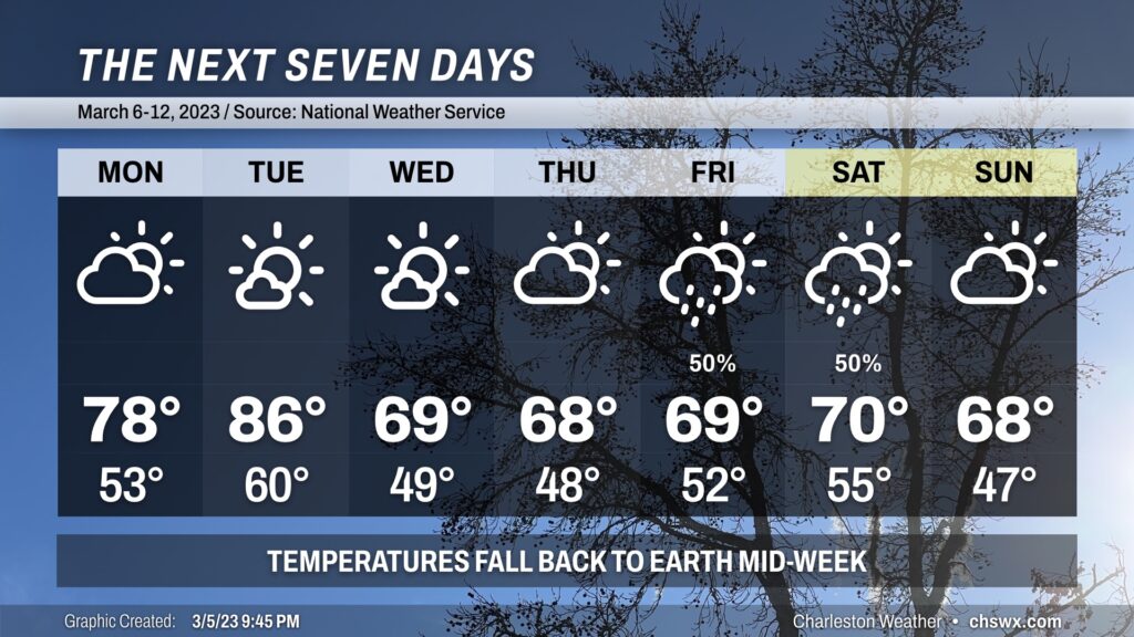
If you’ve enjoyed this stretch of exceptionally warm weather for this point in the year, savor the next couple days as we will be cooling off by mid-week, with this cooler weather looking to persist for a while as the pattern flips more favorably for below-normal temperatures for much of the continental US.
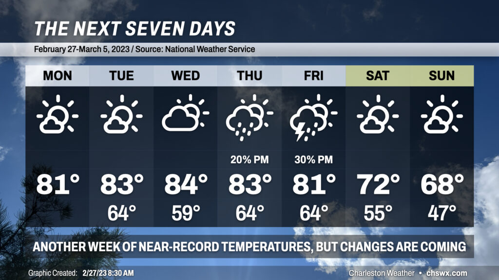
We’re back in the 80s starting today as much warmer-than-normal temperatures continue across the Lowcountry. We may once again threaten record highs over the next few days with temperatures topping out in the low to mid-80s each day through Friday. Lows in the mid-60s most days (except for Wednesday, the result of a weak front) will also challenge record high minimum temperatures across the region — indeed, this remains unusually warm weather for this point in the year and The Pollening should, unfortunately, continue apace.
Changes are coming later this week for the weekend, though. A strong cold front looks to approach the area Thursday into Friday, which will shift the airmass more substantially and get temperatures back within striking distance of early March normals. This will come with the risk for strong to severe thunderstorms on Friday afternoon, with strong winds expected even outside of thunderstorms. We’ll want to watch this closely for later this week, but there’s still model difference right now in the exact track of the storm system. Stay tuned.
Regardless of what pans out with the severe weather threat, we’ll have a much more seasonable — but still warmer-than-normal — weekend ahead with highs topping out in the low 70s Saturday and the upper 60s on Sunday. Lows will fall back to earth as well, with the first lows in the 40s since February 20 in the forecast. The good news in all this is that we should see plenty of sunshine this weekend to go along with the more comfortable temperatures. (Just take some precautions against the pollen if you are sensitive to it.)
High pressure at the surface and aloft will keep very warm temperatures in the forecast for much of the week with no rain to show for it as strong subtropical ridging more characteristic of late spring/summer builds across the area. Put another way: It’s a scary week to be a record high at the North Charleston climate site.
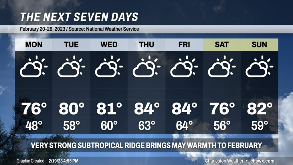
As has been true of the pattern for much of 2023 thus far, rain will have long since departed by Monday, which should end up being a rather beautiful day after starting in the upper 30s. Few, if any, clouds are expected as high pressure builds in; highs top out in the mid-60s. Another similarly beautiful, if not slightly warmer, day is on tap for Tuesday as highs approach 70° in the afternoon — really hard to ask much more for Valentine’s Day.
70s return in full force by Wednesday as high pressure moves offshore and winds go back to the south. We’ll see this accompanied by an increase in cloud cover through Thursday ahead of another cold front. Rain returns Friday, but shouldn’t be quite as much as we saw with this past weekend’s storm system, nor will it hang around as long. Cooler high pressure returns for the weekend, with highs in the mid-50s for Saturday but rebounding quickly into the the upper 60s for Sunday. At least it won’t be raining — feels like forever since we had a rain-free weekend!
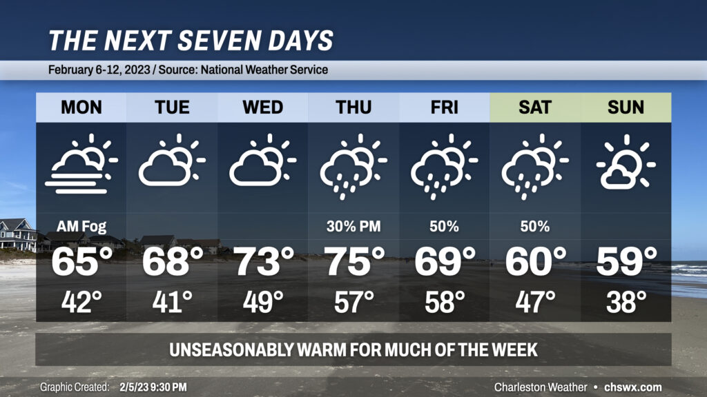
Unseasonable warmth lies ahead for a good chunk of the upcoming work week before showers, maybe some storms, and then more seasonable temperatures arrive for the weekend.
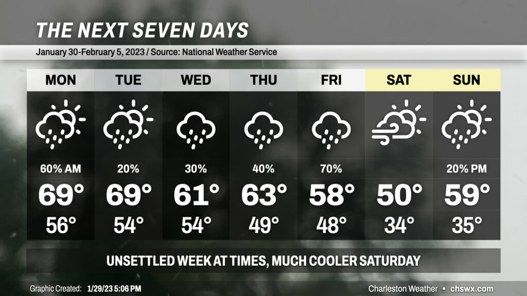
The week ahead will feature temperatures generally at or slightly below normal for this point of the year aside from Wednesday, when temperatures will head into the low 70s ahead of a cold front.
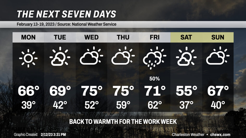
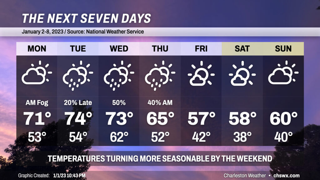
We’ve got a pretty quiet week of weather ahead aside from a frontal passage overnight Thursday into early Friday morning, which should spread some showers and maybe a thunderstorm through the area. Highs for much of the work week will run in the mid-60s, with temperatures approaching 70° on Thursday. Lows on Monday will bottom out around 50°, with a couple chillier mornings ahead for Tuesday and Wednesday with lows in the low 40s before warming back to 50° for Thursday and Friday morning.
The best chance of rain arrives late Thursday night into Friday morning, with showers expected. A thunderstorm or two can’t be ruled out ahead of the front, either, but timing will generally be a little less favorable climatology-wise for thunderstorms. Rain comes to an end Friday morning, and the cold front will be clearing the area during the day. Cooler and drier air filtering into the area will limit highs to the low 60s in the afternoon. Saturday will be as chilly of a start as we’ve seen since the turn of the year with lows in the mid-30s. Highs on Saturday will struggle to the low-to-mid-50s, while Sunday will run a little warmer with highs in the mid-50s after starting solidly in the mid-30s. Overall, though, not too shabby for the first full work week of 2023.
We’ve got a few more warm and muggy days ahead to start 2023 before a front gets through mid-week, bringing temperatures closer to early January normals.
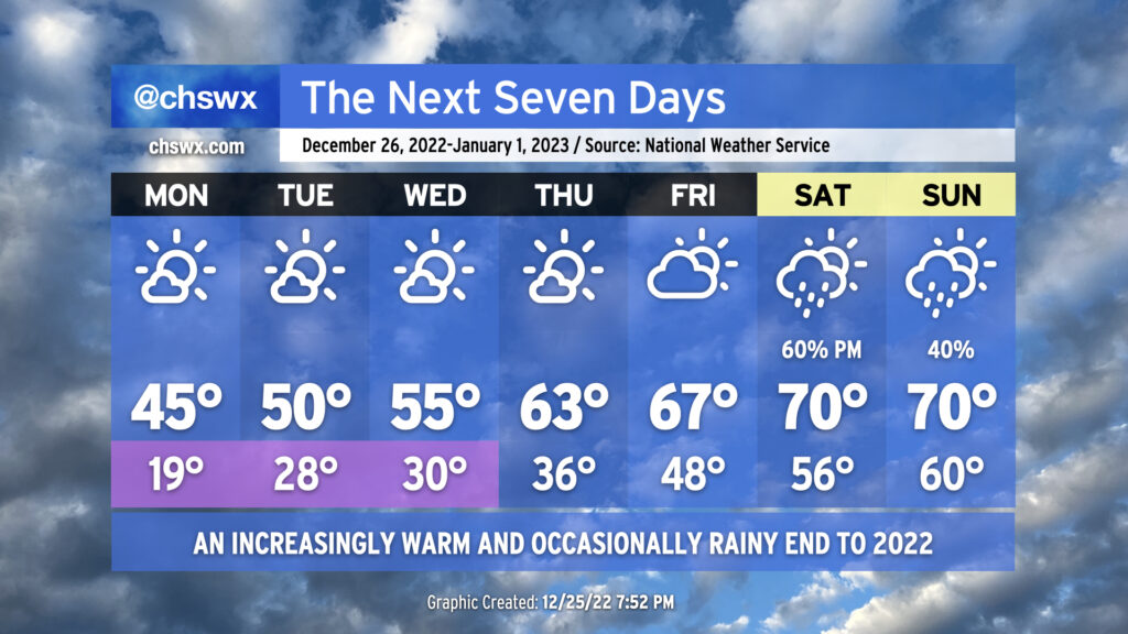
We begin the final week of 2022 with Arctic air continuing to make its presence felt across the area. We’ll start Monday in the upper teens to low 20s, with freezing temperatures all the way to the coast once again. It’ll be another night to make sure that pets, plants, and people are well accounted for, and that pipes are protected with extra insulation and a dripping faucet. Highs will top out again in the low-to-mid-40s under predominantly sunny skies.