Jared Smith founded @chswx on Twitter in 2008 as an experiment in disseminating weather data through social media. In the ensuing decade-and-a-half, @chswx has provided live coverage of tropical cyclones, tornadoes, severe weather, and even a couple bouts of winter weather to the good people of Charleston, SC.
Breezes will turn southerly on Tuesday as high pressure slips offshore, allowing temperatures to rise near to near 80° in the afternoon under mostly sunny skies. Humidity will be a touch higher, but you probably won’t notice — should be another really nice day. Try to enjoy!
It’s been a couple weeks since I’ve even generated one of these seven-day graphics because I’ve spent the past two Sundays intensely focused on an overnight severe weather threat heading into the following Monday.
No such issues this week — in fact, the only severity in the weather on Monday will be how severely nice it will be. We start the new work week in the low 50s and end up in the mid-70s under full sunshine. 80s return on Tuesday as high pressure gradually shifts offshore. Our next rain chance should arrive by Wednesday night into early Thursday morning as a storm system crosses the Great Lakes, sending a trailing cold front down our way. A few thunderstorms are possible as well, but no severe weather is currently expected. We will clear out during the day Thursday, setting us up for an increasingly warm and mostly sunny weekend as we start May.
After the last two weekends of agonizing over the potential for severe weather in the Lowcountry, a quiet weekend is more than welcome. There will be slight chance of a shower or storm on Saturday afternoon as a cold front swings through, but moisture return is meager and so just an uptick in cloud cover is expected.
Sunday looks pretty great for a change — partly cloudy to mostly sunny skies with highs topping out right around 80° will make for a much nicer day than we’ve had the past couple Sundays. Take advantage as best as you can given our continued socially-distant circumstances!
As many of us had hoped for, the risk for severe weather was overtaken by stable, steady rain moving in across the Lowcountry this afternoon. There are still some rumbles of thunder, and certainly some decent rainfall in spots, but the risk for damaging wind gusts and tornadoes has ended in the Lowcountry.
Our active severe weather season continues with another risk of damaging wind gusts and perhaps a tornado or two this afternoon into the evening hours. (At least we will be awake for this one — in 2020, you take the wins you can get.)
Tuesday will be a mostly sunny day in-between cold fronts. Winds will turn from the south to the southwest throughout the day, allowing temperatures to swing from the mid-50s to around 80° in the afternoon. No weather hazards to speak of for Tuesday, thankfully — business as “usual” (by 2020 standards, anyway).
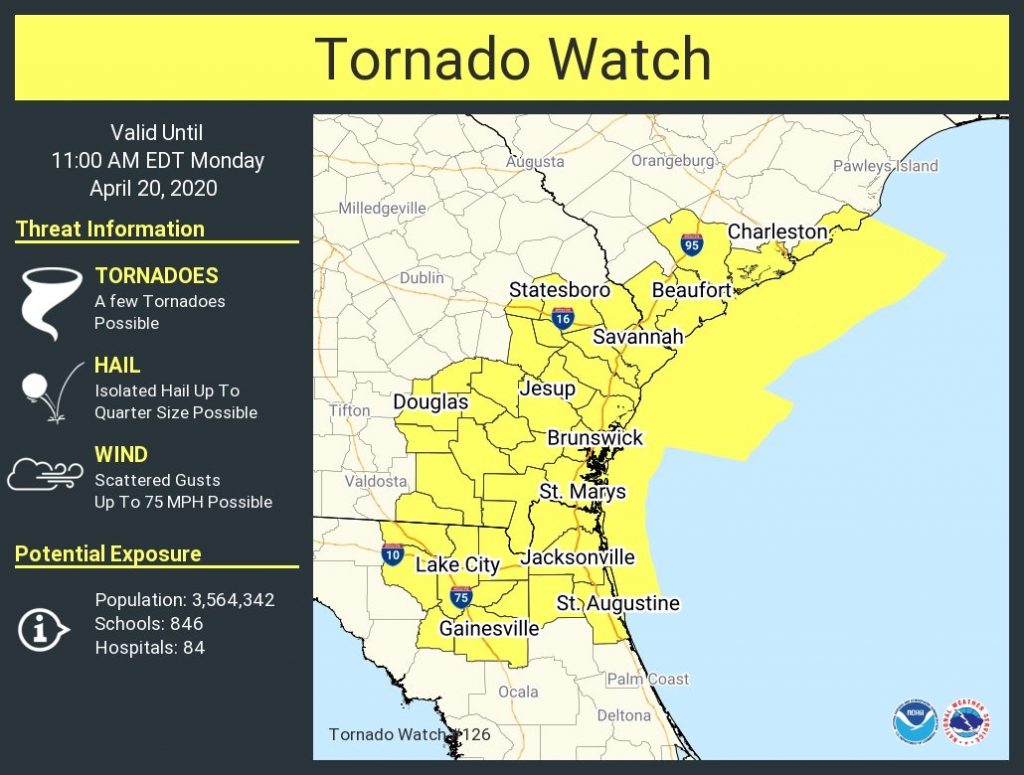
UPDATE: As of 6:44am, the tornado watch for Charleston County has been canceled. The severe weather threat is over. Previous reporting below, for posterity:
A Tornado Watch has been issued until 11 am for Charleston County and the adjacent coastal waters. We continue to monitor the progression of a warm front that looks to destabilize the atmosphere primarily in the immediate Charleston metro area for now.
Inland counties (looking at you, Berkeley and Dorchester) remain in a very stable airmass. While the warm front could impinge upon these areas and yet destabilize here, it appears that the main threat for severe weather will be along the coast through the morning. With that in mind, though, trends will be watched, and it is possible the Watch may be extended further north.
In addition to tornadoes, gusts to 75 MPH will be possible as a potent low-level jet develops along the coast. Remember, straight-line winds can still cause plenty of problems; they account for a vast majority of the weather-related damage we see here.
This will be the live blog for this morning’s event. (Or, with any luck, non-event.) Follow along with updates below…
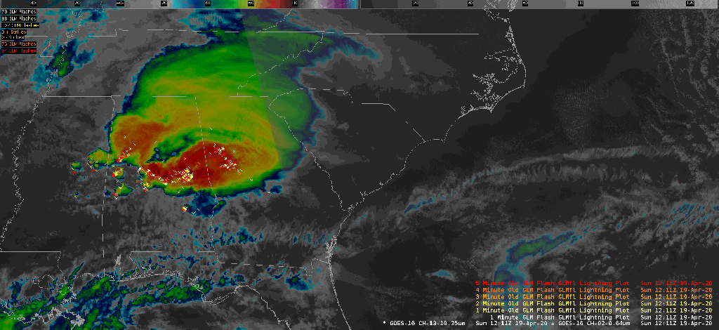
Another rough morning is in the cards with a squall line expected to move through the area. Said squall line may produce damaging wind gusts, hail, and tornadoes — a couple of which may become strong.
The squall line should be through the area by 11am, according to the latest NWS briefing. This seems reasonable, and I wouldn’t be surprised if it was out of here a lot sooner than that.
Some overnight severe weather is not out of the cards, but it increasingly appears that the threat for severe weather in the Tri-County area will arrive around sunrise. Still, don’t go to bed without having weather warnings that can wake you.
Flooding may be a concern, particularly around the 7:12am high tide.
Once the squall line clears the area, winds will shift northwest and we should see at least some partial breaks in the clouds before the day is over.
Good Sunday morning to you all. Once again, the Charleston metro area finds itself watching the weather intently for the potential for a few strong to severe thunderstorms, particularly tonight into tomorrow morning. The area is outlined with an enhanced severe weather risk, which is a 3 out of 5 on the Storm Prediction Center’s scale. Unfortunately, damaging winds and potentially strong tornadoes are once again on the table.
Our active spring severe weather season looks to continue Sunday night into Monday morning, as a potent storm system traverses a ripe, well-sheared airmass in the Southeast with the potential for tornadoes and damaging winds.