Jared Smith founded @chswx on Twitter in 2008 as an experiment in disseminating weather data through social media. In the ensuing decade-and-a-half, @chswx has provided live coverage of tropical cyclones, tornadoes, severe weather, and even a couple bouts of winter weather to the good people of Charleston, SC.
At 8am, Isaias — not the most picturesque hurricane one has ever seen, but a hurricane nonetheless — was making its move on Andros Island in the Bahamas. The storm has been struggling with westerly shear and dry air intrusion, which will keep its intensity capped for now. Today is a pivotal day in the evolution of the storm’s track for the next few days, and we’ll all want to keep an eye on it as we begin to prepare for its arrival Monday.
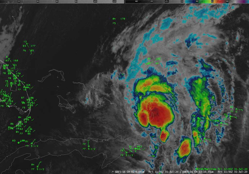
It’s not the most picturesque hurricane on record, but it will do: Hurricane Isaias, which was upgraded after Hurricane Hunters found winds near 80 MPH last night, is now churning through the Bahamas this morning. Isaias remains a Category 1 storm as of this morning with 80 MPH winds, and is moving NW at 17 MPH. It is expected to strengthen to a Category 2 storm with max winds of 100 MPH before weakening as it curves up the US coast this weekend.
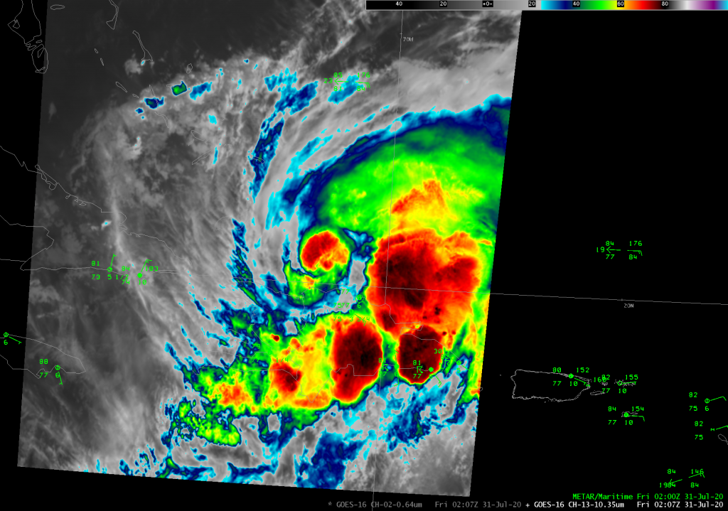
Tropical Storm Isaias was named with the 11PM advisory last night, and it has brought flooding rain to Puerto Rico over the last couple days as it moved nearby and through Hispaniola. This evening, the center of the storm is reforming on the north side of Hispaniola. There was some speculation that the mountainous terrain of the island would potentially seriously disrupt the storm, but this appears to be a case where that didn’t happen. At 8PM this evening, the storm maintained 60 MPH max sustained winds with the minimum central pressure down to 999 millibars.
Potential Tropical Cyclone Nine — which may become Tropical Storm Isaias later today — continues to churn into the Caribbean this morning. Its satellite presentation has improved over the last couple days, and is beginning to show signs that it might be finally getting its act together enough to become a tropical cyclone. It’s bringing heavy rain to the Leeward Islands and will spread its effects into Puerto Rico later today.
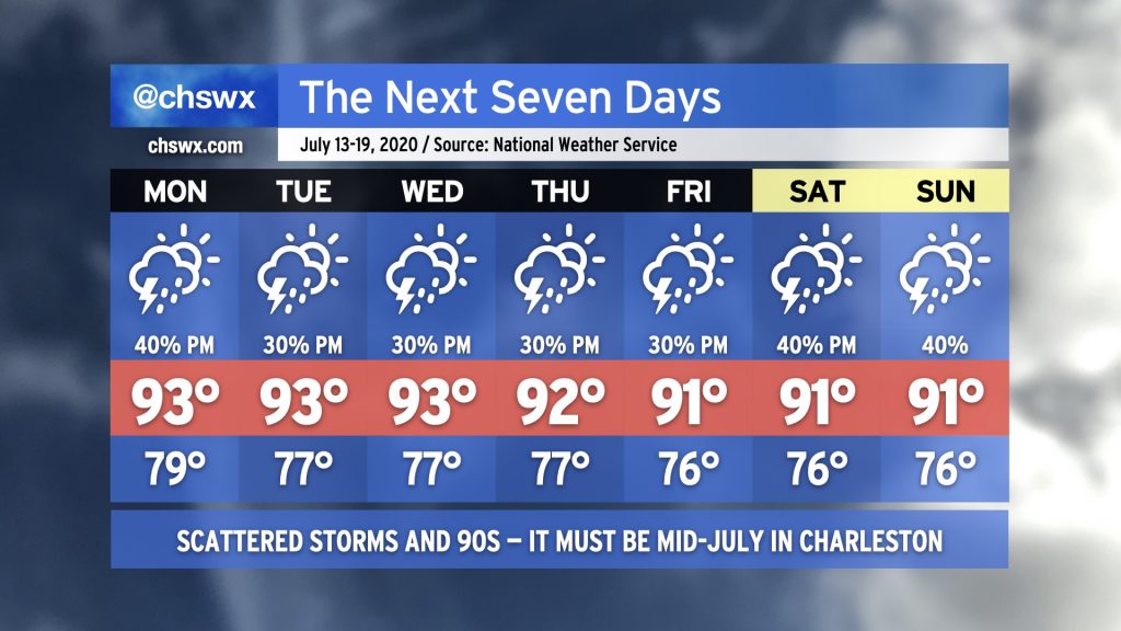
We continue our midsummer heat, humidity, and thunderstorm chances as we close out July and head into August. Temperatures will continue to run in the low 90s each day; heat indices will top out in the low to mid-100s in the afternoons before the onset of thunderstorms. After more isolated coverage on Monday, expect an uptick for much of the rest of the week with a little upper-level support getting in on the action. Some of you who have been on the “miss” side of the “hit-or-miss” thunderstorms these past few days will have plenty of chances to get a free lawn watering in the upcoming week!
Stop me if you’ve heard it: We’ll see highs in the 90s, heat indices in the 100s, and a chance of thunderstorms pretty much every afternoon along and inland of the seabreeze. We might see a little uptick in shower and storm activity as we head toward the weekend as models suggest a little mid-level energy trying to work its way in, but we’ll keep an eye on this trend. Stay cool and masked up!
We will find ourselves firmly in a slightly unsettled summertime pattern for much of the week. Highs will top out in the low to mid-90s each day, with heat indices in the low to mid-100s in the afternoons. Showers and thunderstorms will be possible each day. It won’t rain all the time, and you probably won’t see rain every day, either. Mind the heat — take frequent breaks in the afternoon, get plenty of fluids, and seek out air conditioning when you can. Don’t forget to wear a mask!
We’ve got a soggy, stormy start to the week in store as a low pressure system moves through the Gulf Coast states and strafes our coastline. We’re already starting to see some shower activity from this storm system this evening, and more is expected through at least Wednesday night, if not beyond.
We’ve got a fairly active week of weather ahead as we move toward Independence Day this weekend. First off, the warmth: Temperatures will push the mid-90s on Monday and Tuesday, and the humidity will push heat indices well into the 100s. Could scrape 105° at times, so be sure that you are hydrating well and taking plenty of breaks if you’re outdoors.
Thunderstorms will feature prominently in the forecast this week as we remain in northwest flow aloft Monday and Tuesday. This will allow thunderstorm complexes to move into the area from the northwest, potentially packing strong winds and heavy rain. Thereafter, a trough of low pressure aloft and at the surface will keep us in a fairly unsettled pattern, with showers and thunderstorms possible each afternoon with peak heating. This pattern may last into the weekend, so be thinking about indoor alternatives to your July 4 plans now, just in case. Will keep an eye on it to see how things evolve throughout the week. Stay tuned.
High pressure ridging overhead is going to keep thunderstorm chances low and temperatures up for Friday and the weekend. Couple that with a side of Saharan dust advecting in from the southwest and we’ll have a few hot, hazy, and humid days ahead. In fact, during the afternoons, heat indices may approach the upper 90s to around 100 at times, so be sure you’re getting hydration if you are outdoors. A stray thunderstorm or two will be possible Friday and Saturday afternoon, with a tighter lid on potential storms for Sunday (as things stand right now, anyway).
Sunsets could be particularly colorful Saturday and Sunday night, as NASA dust modeling suggests peak Saharan dust activity around these times. It remains to be seen what, if any, air quality impacts there will be, but we’ll want to keep an eye on that for sensitive groups, especially with our recent acceleration in coronavirus cases aggravating respiratory matters.