Jared Smith founded @chswx on Twitter in 2008 as an experiment in disseminating weather data through social media. In the ensuing decade-and-a-half, @chswx has provided live coverage of tropical cyclones, tornadoes, severe weather, and even a couple bouts of winter weather to the good people of Charleston, SC.
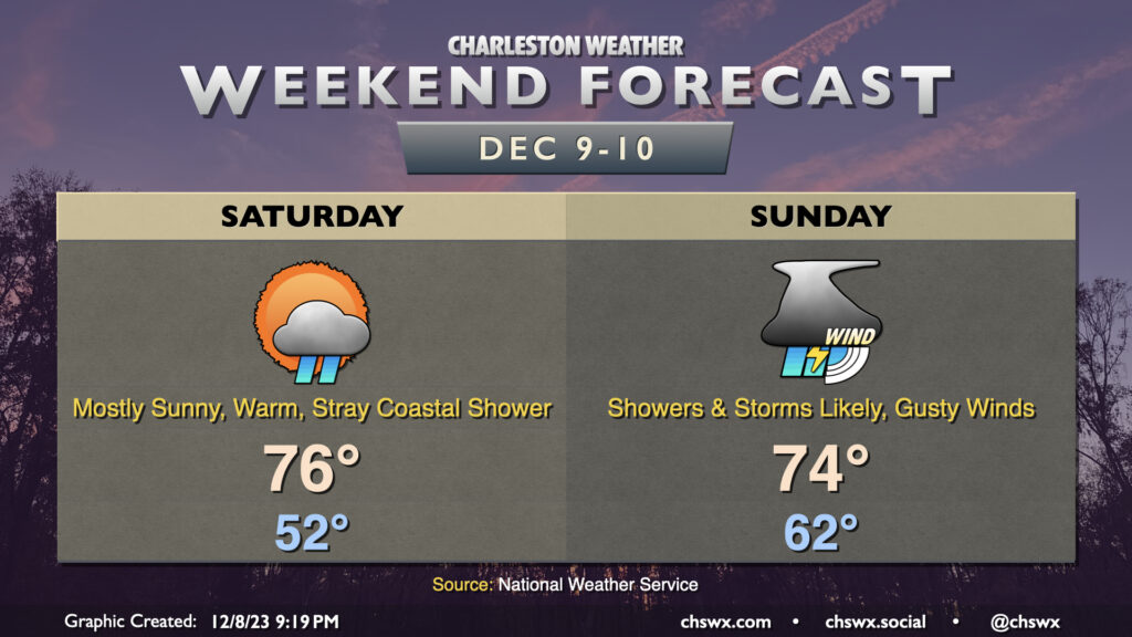
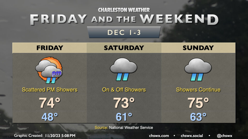
So, let’s get this out of the way: If you’re going to do stuff outside this weekend, do it Saturday. Temperatures will be unseasonably warm and there will be plenty of sunshine. Expect to start the day in the low 50s — a good ten degrees or more warmer than many of us started this morning — with highs topping out in the mid-70s in the afternoon. Aside from the risk for a stray coastal shower to sneak ashore at times, much of the metro gets Saturday in rain-free.
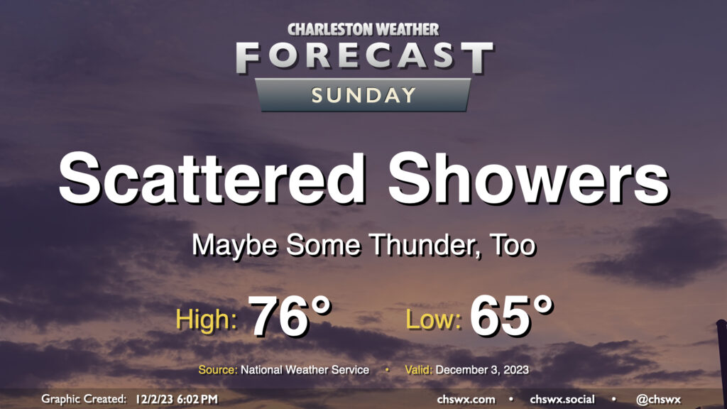
Sunday should be a different story. The first thing to note is that it probably won’t rain all day — there will be breaks, especially in the morning and early afternoon. However, winds will be cranking up with gusts approaching 30 MPH (and likely higher on bridges and overpasses, especially closer to the coast) ahead of a band of showers and a few thunderstorms that looks to push through during the mid-afternoon and evening hours. These could bring down some even stronger wind gusts especially inland of 17, but widespread severe weather isn’t expected given a lack of available instability. We should see any thunderstorms weaken as they approach the coast and the locally more stable air thanks to shelf waters in the upper 50s. Still, keep an ear out for possible statements or warnings in case a strong thunderstorm approaches your location.
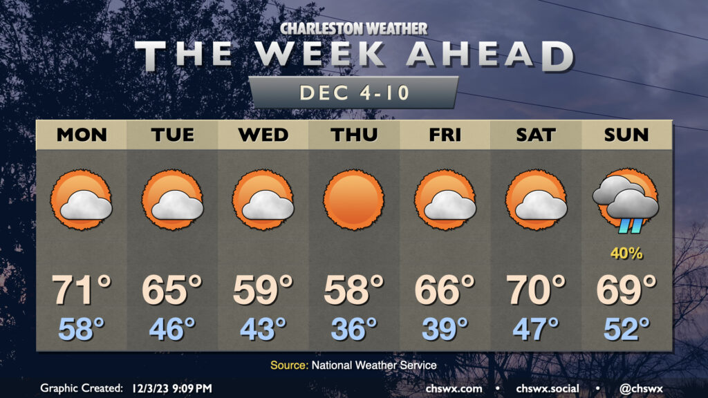
Rain tapers off overnight Sunday as the front gets by, and it looks like high pressure will keep things on the cool side of normal for much of next week.
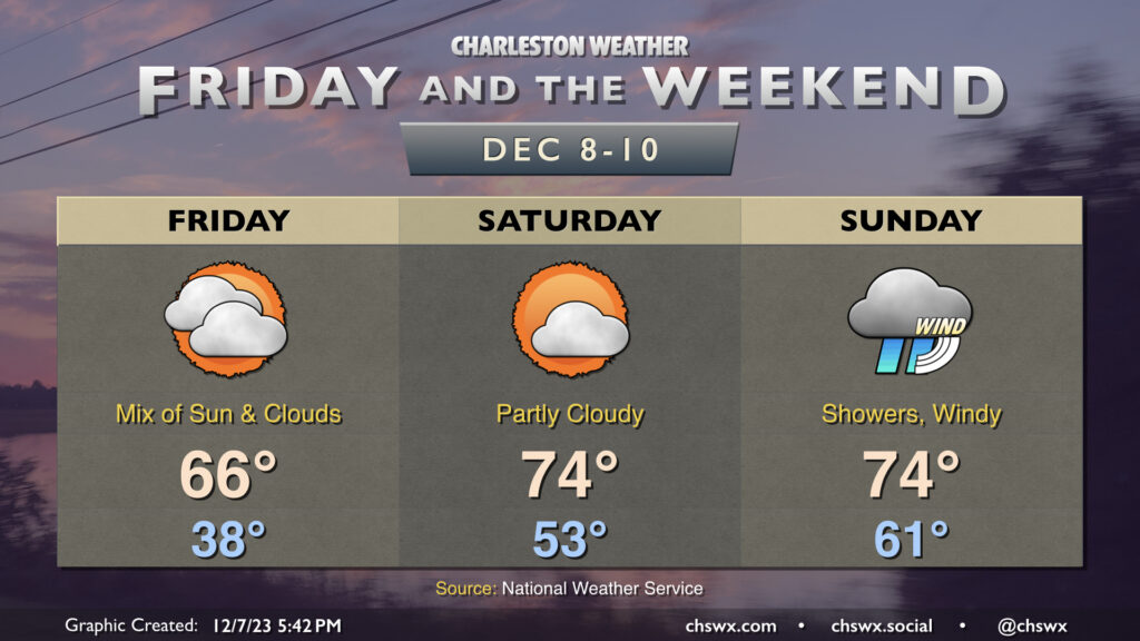
Another round of chilly weather is expected overnight Thursday into Friday. We’ll wake up to temperatures in the upper 30s Friday morning, but high pressure slipping offshore will allow temperatures to warm up to the mid-60s in the afternoon under a mix of sun and clouds. Overall, Friday looks pretty good.
The warming trend continues into the weekend. Saturday is the pick day of the weekend for outdoor activities, and it really isn’t close as a front gets through Sunday. It starts significantly warmer than Friday did, with lows in the low to mid-50s expected. Highs will top out in the mid-70s under generally partly cloudy skies. This will be the last warm and quiet weather day for at least a few days, so try to take advantage!
The weather changes fairly quickly overnight Saturday into Sunday as a strong storm system’s cold front drives toward the area. Sunday gets off to another unseasonably warm start, with lows in the low 60s expected. Showers may be firing off first thing Sunday, but the main band of rain associated with the front looks to arrive later in the afternoon and evening. Wind will be another factor, with gusts upwards of 30 MPH appearing possible at times, even outside of storms. The risk for severe weather is quite low, owing to the minimal available instability that’s expected despite no shortage of bulk wind shear. Still, some thunder is possible, and if additional instability can kick up, a strong to damaging wind gust or two is not out of the question. More fine-tuning of the forecast will occur, but generally speaking, Sunday just doesn’t look promising to be outside.
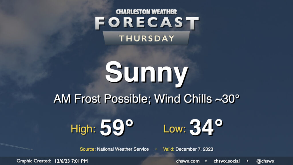
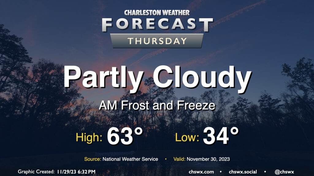
Thursday will represent the bottom-most point of this week’s temperatures rollercoaster, with lows bottoming out in the mid-30s across much of the metro with freezing temperatures further inland. Frost is a distinct possibility, and you’ll want to have pets and plants inside overnight Wednesday. Cool high pressure moves across the area during the day Thursday, limiting highs to the upper 50s to around 60° despite predominantly sunny skies.
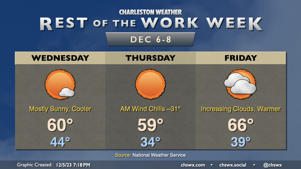
Another cool couple days lie ahead as a reinforcing front comes through early Wednesday morning. This will be a pretty solid shot of cool and dry air as high pressure builds in from the west. We’ll start Wednesday in the mid-40s, but the cooler air rushing in will limit the high to around 60° in the afternoon despite primarily sunny skies. It’ll be a bit breezy, with gusty winds out of the northwest at times, so some element of wind-breaking may be ideal.
Thursday will be the coolest day of the week. We’ll start the day in the mid-30s, with inland locations possibly approaching freezing. A light wind will make it feel a little cooler, with wind chills in the low 30s across the metro. Skies will once again be predominantly cloud-free, but the cold high pressure settling in will hold highs to the upper 50s to around 60°.
High pressure slips offshore Friday, and this allows some warmer air to move back in. We start Friday in the upper 30s to around 40°, but temperatures will warm back toward the mid-60s in the afternoon. Clouds will also be increasing as a coastal trough begins to take shape nearby, but rain is not expected.
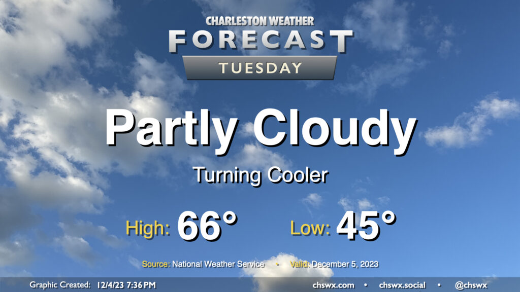
A reinforcing shot of cool air arrives overnight, and by Tuesday morning, we’ll wake up to temperatures about 10-15° cooler than we woke up to on Monday. Expect to start the day in the mid-40s before warming to the mid-60s in the afternoon under partly cloudy to mostly sunny skies. These temperatures are right around normal for December 5.
After a weekend in which clouds were prevalent but rain perhaps not so much, we get into a mostly quiet week ahead despite a few frontal passages that will gradually cool us off as we move through the week.
A cold front approaching the area should kick off some scattered showers at times throughout the day, with the best chances for rain generally occurring around midday to early afternoon. It’ll be one more unseasonably warm and muggy day across the area despite full overcast: lows will bottom out in the mid-60s — right in the neighborhood of the typical high for early December — with highs topping out in the mid-70s in the afternoon. It may be warm enough for some instability to develop, which could lead to a thunderstorm or two even as the front gets closer during the evening. No severe weather is expected, though. Generally speaking, rainfall amounts won’t be much to write home about — a few hundredths of an inch for most, with perhaps some locally heavier accumulation if a storm can fire. Shower chances taper after sunset, with the front to follow overnight.
The weekend will be unseasonably warm with off and on showers, particularly starting Saturday afternoon and lasting into Sunday. The first thing of note will be the low temperatures in the low to mid-60s each morning. The normal high for early December runs around 67° or so…and we’ll be within striking distance of that in the mornings. Afternoon highs will be tempered by cloud cover and shower activity, but will still run well above normal in the mid-70s. As for the rain, it looks to be fairly on and off, with models hinting that a thunderstorm complex moving across the Gulf Coast into Florida may rob some of the moisture transport into the area. This could act to reduce the amount of rain we ultimately receive and may make the weekend look like less of a washout than first thought. We’ll keep an eye on this, but keep rain gear handy anyway and be ready for travel issues, because when it sprinkles, traffic snarls.
Our recent chilly spell will come to an end on Friday as warmer and more humid air moves back in just in time for the start of meteorological winter (December-February). We start Friday in the upper 40s — well above where we have started the past few mornings — and warm to the mid-70s in the afternoon. Unfortunately, showers will also be returning to the forecast, with isolated to scattered showers developing in the afternoon and increasing in coverage overnight heading into Saturday.
Saturday should feature the greatest shower coverage, with on and off rainfall expected. It’ll still be warm, though — lows start in the low 60s, roughly where our high was on Wednesday — with temperatures heading to the low-to-mid-70s despite the rain in the area. Showers will keep on going into Sunday, though coverage may become a little more sparse as we head into the afternoon and evening hours. That being said, most of the models still have showers going well into Sunday night, so keep the rain gear handy. We’ll run about as warm, if not slightly warmer, than Saturday, with highs running solidly in the mid-70s.
Keep those plants covered or indoors: Frost and freeze conditions will return Wednesday night into Thursday morning as cool high pressure remains in place for one more day. Lows will bottom out in the low to mid-30s in much of the metro, with the warmer temperatures near the water. We could even see some 20s further inland and in more rural locations as well. Make sure your pets have a safe place to be tonight!
Temperatures on Thursday will warm to the low-to-mid-60s in the afternoon under partly cloudy skies, perhaps running a few degrees warmer than Wednesday’s highs, but still on the cool side of normal for late November.