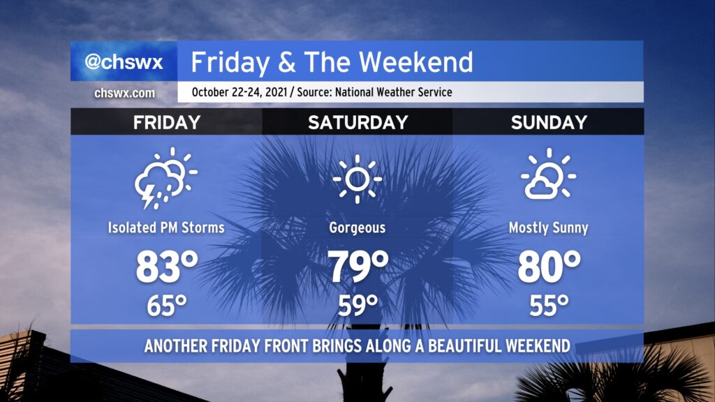
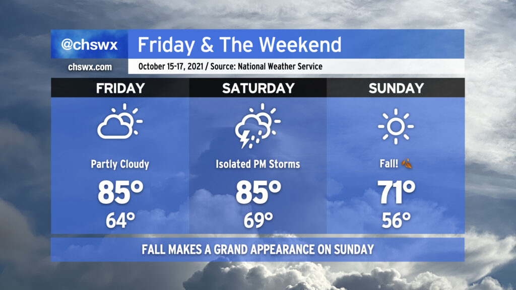
We’ve got more excellent weather on the way for this weekend, but first, we deal with a weak cold front on Friday. A few showers and storms could pop off in the afternoon ahead of said front before it swings through, but the vast majority of us look to stay dry. Expect warmer-than-normal temperatures, especially in the morning where we get started in the mid-60s away from the warmer coast and top out in the low-to-mid-80s in the afternoon.
Once the front is through, another area of dry high pressure works into the area. Saturday looks extremely good, starting out in the mid-to-upper 50s with highs topping out shy of 80°. After another cool start in the mid-50s, Sunday will warm to around 80-81° under mostly sunny skies. Enjoy!
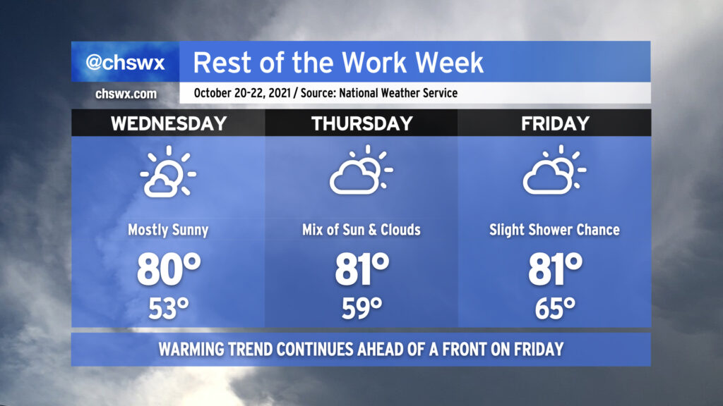
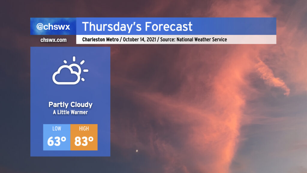
A warming trend will continue for the rest of the work week ahead of a cold front swinging through on Friday. Highs look to return to the 80s for Wednesday and beyond, though just barely. Lows will be creeping up more noticeably; we’ll wake up to low 50s on Wednesday, near 60° on Thursday, and in the mid-60s on Friday.
We stay rain-free through Thursday, and it’s probable that you’ll stay dry on Friday, too, with just a little moisture available for the front to squeeze out a few isolated showers in the afternoon. Overall, our weather pattern remains relatively quiet heading into the weekend, but there’s no sign of another good shot of cold air just yet as the temperature trend continues to favor above-normal temperatures heading into next week. (It is nice to dry out a bit, though!)
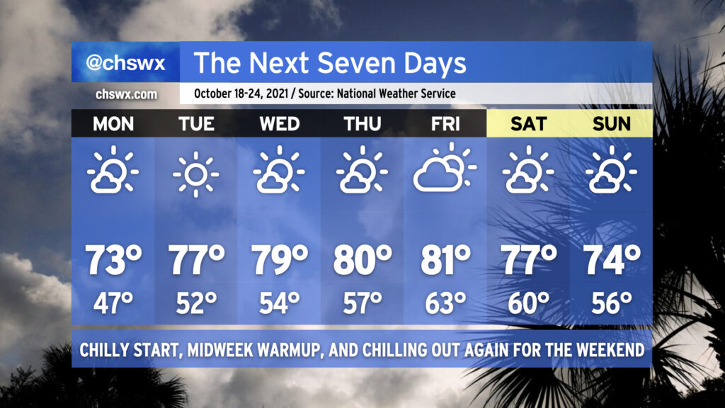
Expect a relatively tame week of weather as a series of high pressure systems transit through the area. We’ll get Monday off to the chilliest start since we bottomed out at 49° on May 15 as widespread 40s are expected under clear skies. Much like today, temperatures will rise back into the low 70s for the afternoon, making for a rather delightful day (weather-wise, at least.)
A warming trend commences Tuesday into midweek as high pressure moves over the area and eventually offshore, allowing temperatures to return to the 80s by Thursday. A dearth of moisture, though, will keep these above-normal temperatures feeling quite alright. A cold front comes through sometime late Friday into Saturday, allowing another area of cooler high pressure to build back in.
It’s a rare week of little to no weather worries: tides remain in check, the tropics are quiet, and we look to stay mostly rain free (unless Friday’s front can squeeze out a shower or two). We’ll have a good mix of cooler and warmer temperatures — really, a little something for everyone. Enjoy it!
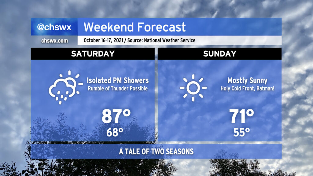
Get ready for a change in seasons this weekend. After a record high of 87° today at the airport, we’ll climb back into the upper 80s for Saturday as a cold front approaches the area. A few showers and maybe a rumble of thunder or two will be possible as the front gets closer, but the general thinking is that there just won’t be the moisture for more widespread rainfall.
Fall fans, rejoice: We will wake up to a significantly more fall-like feel on Sunday morning with lows bottoming out in the low to mid-50s. Much cooler and drier air will continue to move into the area throughout the day, yielding clear skies and highs only topping out in the low 70s despite uninterrupted sunshine. We may see our first 40s of the season in the metro area on Monday morning, too, before a slow warming trend commences for the rest of the upcoming week.
After a record high was tied at Downtown Charleston today (85°, last set in 1975) and records could be challenged on Friday (87° at the airport, last set in 2018), a cold front will knock us solidly into more autumnal weather starting Sunday. We’ll start Friday in the mid-60s (near the low 70s closer to the coast) with temperatures warming into the mid-to-upper 80s in the afternoon, challenging the aforementioned record, with mostly sunny to partly cloudy skies persisting.
Saturday will be it for the 80s for at least a few days as the cold front approaches the area. The incoming front could help spark off a few afternoon and evening showers and thunderstorms, but severe weather — much less widespread heavy rainfall — is highly unlikely.
The front will come through overnight Saturday, and by Sunday morning, it’ll feel a lot different — temperatures will be in the mid-50s away from the coast to start the day, and will only warm up to the low 70s at best in the afternoon under clear skies. We’ll keep this fall feel for at least the first part of next week, too. Get those hoodies ready!
Temperatures will turn a little warmer Thursday as high pressure continues to build aloft. We’ll start the day in the low to mid-60s away from the warmer coastline and warm nicely into the low-to-mid 80s in the afternoon. Some patches of fog will be possible in the morning, so be aware of this as you commute. Thereafter, partly cloudy to mostly sunny skies will be the general rule, and no precipitation is expected once again.
Warming will continue into Friday and Saturday before a cold front moves through Saturday night and plunges us squarely into fall weather, with some of the coolest temperatures since spring coming up heading into next week. Stay tuned!
A beautiful day lies ahead with mostly sunny skies expected and comfortably warm temperatures in the low 80s. Expect a few clouds from time to time, but we should generally see more sunshine than we have the past couple days.
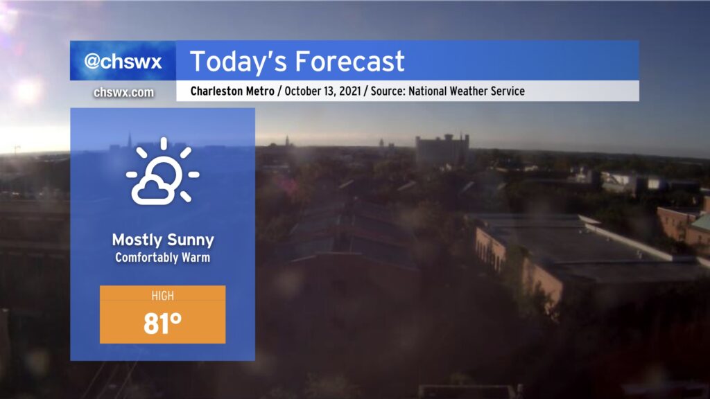
Our warming trend continues through the end of the work week. We still appear to be on track to at least challenge a record high or two before the week is over as highs head into the mid-to-upper 80s.
Looking for fall? It’s coming: A front will swing through sometime Saturday evening, and this will send temperatures closer to, if not slightly below, normal for mid-October starting on Sunday. Stay tuned!
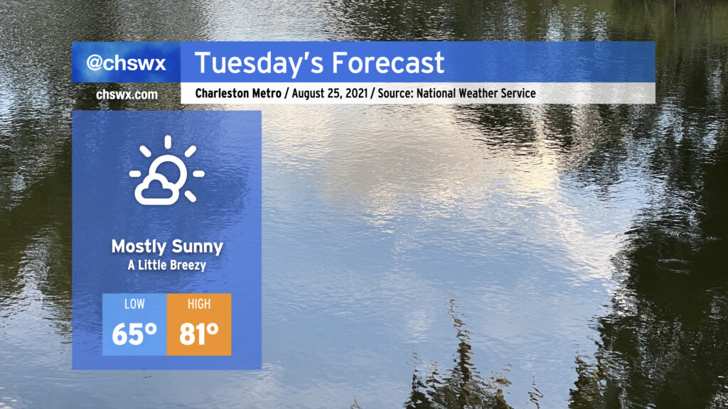
Persistent low cloud cover will break up overnight, yielding a pretty nice Tuesday across the Lowcountry as high pressure continues to build in over the area. Temperatures will be seasonably, but not unreasonably, warm as we begin the day in the mid-60s to head to a high of 81° under mostly sunny skies. The north to northeast breeze could be a touch gusty at times, but no major concerns to speak of there.
A brief bout of minor coastal flooding will be possible around the 1:52 PM high tide as water levels in the harbor are forecast to touch 7′. This won’t cause widespread problems, but should still be high enough to put some salt water on Fishburne and Hagood around the Citadel and Gadsden Creek.
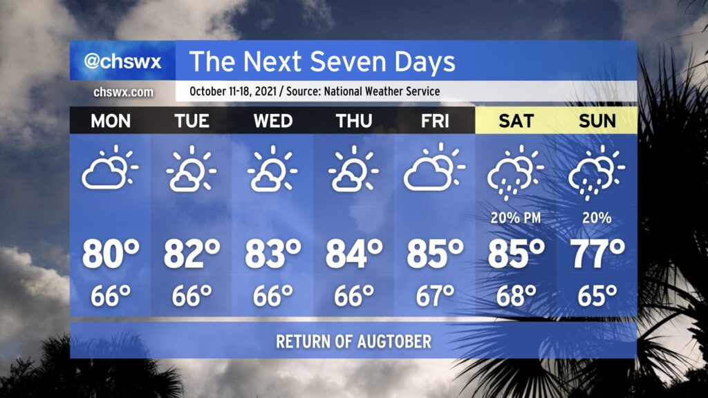
The upcoming week looks much more rain-free than the past week was, as ridging aloft builds across the area. Said ridging will drive temperatures up toward “Augtober” levels by the end of the week — mid to upper 80s will be possible, challenging record highs — but the good news is that humidity will remain tolerable. Monday looks to be a rather nice weather day as we begin the day in the mid-60s and top out in the low 80s with a mix of sun and clouds, a lot like what we saw Sunday.
A front looks to get by the area sometime during the upcoming weekend, and that will have a bit of a downward effect on temperatures, with highs in the 70s in the long range as we get into next Sunday. There are some hints of a little more crisp fall weather as we get into early next week, but we will need to see how things pan out with the front and high pressure behind it. Stay tuned.
Finally, coastal flooding issues will taper off early this week, but minor flooding will be possible once again an hour or two around the 12:46 PM high tide on Monday. This could close a few roads in downtown Charleston, especially near the Citadel and MUSC. The current forecast has some lingering effects for the Tuesday afternoon high tide as well, but it remains to be seen if winds will be enough to push us over the 7’ threshold.