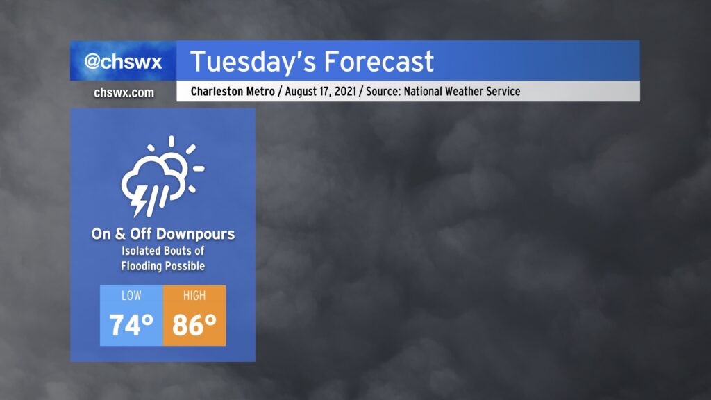
Get ready for periods of heavy rain tonight into Tuesday as Fred, which made landfall earlier near Cape San Blas, FL, continues its northward trek through Alabama and Georgia tonight into Tuesday. Deep tropical moisture will be the name of the game, and models show a feeder band-like feature off of the Atlantic coming up through the area early Tuesday morning. There’s a chance that the band could be moving through the area during the morning rush, so that’s certainly a trend to watch closely. We should see a lull followed by another renewed round of showers and thunderstorms as daytime heating takes hold. All in all, NWS is forecasting another 1-3” of rain (with locally higher amounts) before it’s all said and done Tuesday night.
Given the eastward nudge in Fred’s track over the last day, we’ll be keeping an additional eye out in case conditions become marginally favorable for severe weather closer to the Lowcountry. Right now, it looks like the bulk of the severe risk will stay to our west and northwest, cutting through Georgia into the Upstate. Still, shear profiles suggest that there could be a small window for severe storms late tonight into tomorrow. It may not be the worst idea to have your weather radios in the on and alerting position overnight, just to be safe. It’s important to note that this is not another Elsa: the center of circulation is much further to the west this go-around, and that in turn keeps the more favorable tornado parameters west.
Temperatures will predictably remain suppressed in the mid-80s given the prevalent cloud cover and rainfall. This remains a few degrees below normal for August.
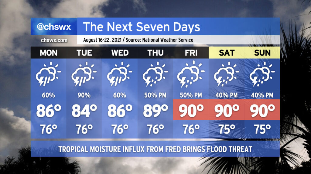
Our soggy summer rolls on with the return of widespread showers and thunderstorms for the first part of the week, particularly as Tropical Storm Fred makes landfall along the Florida Gulf Coast sometime tomorrow and moves northward through western GA into TN. While we won’t see direct impacts from Fred, we are certainly going to be within a plume of deep tropical moisture for the next several days, and this will lead to heavy downpours as a result. Models certainly suggest Tuesday as the wettest day as Fred lumbers up the AL/GA line. A few more inches of rain will certainly be possible, especially in isolated spots where the heaviest downpours occur. We’ll need to keep a close eye out for flooding issues, especially if heavy rain occurs near high tide downtown. The rainfall will keep temperatures in the mid-80s through Wednesday.
As we get into Thursday, Fred’s remnants will be out of the way and we look to begin to return to a somewhat more normal afternoon thunderstorm pattern heading into the weekend. Temperatures will respond by heading back to around 90° each afternoon before thunderstorms fire up.
We in #chswx continue to track two tropical systems in the Atlantic basin, Fred and Grace. Fred has opened up into a tropical wave for the time being, and is thus not currently a tropical cyclone, but is expected to reorganize into one and approach the Florida Panhandle as a tropical storm. Grace, meanwhile, is bringing very heavy rain to the Lesser Antilles this evening as it generally follows in Fred’s footsteps. The good news is that there are no immediate tropical threats for the Lowcountry and the rest of the Carolinas.
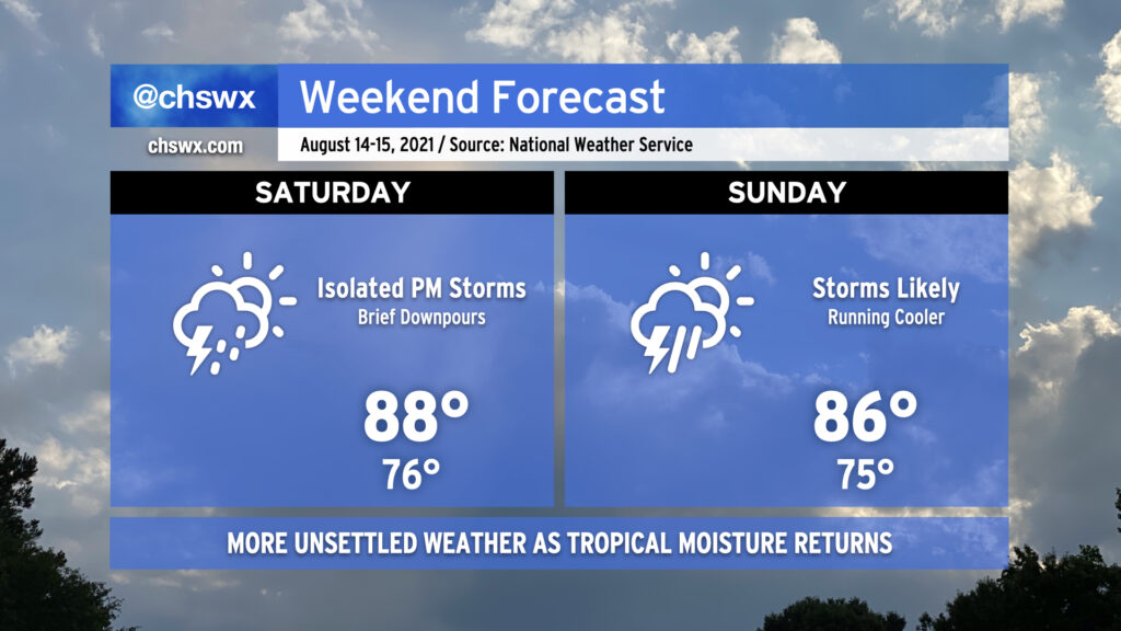
Pro tip: Mow the lawn Saturday morning, because we could start to see some showers and storms enter the picture in the afternoon as high pressure begins to weaken across the area. It’ll still be warm, but temperatures will be limited to the upper 80s by more pervasive cloud cover.
Why mow Saturday? Because Sunday is going to be a lot tougher to get that mowing in, and it doesn’t get better getting into next week. Showers and thunderstorms look to become a little more widespread Sunday, with on-and-off storms possible for a good bit of the day. As usual in summer, it won’t rain all the time, but when it does, a brief downpour or two could drop a decent amount of rain.
As we get into next week, a continued feed of tropical moisture and a stalled front will interact will keep scattered to widespread showers and thunderstorms in the forecast, particularly in the afternoons.
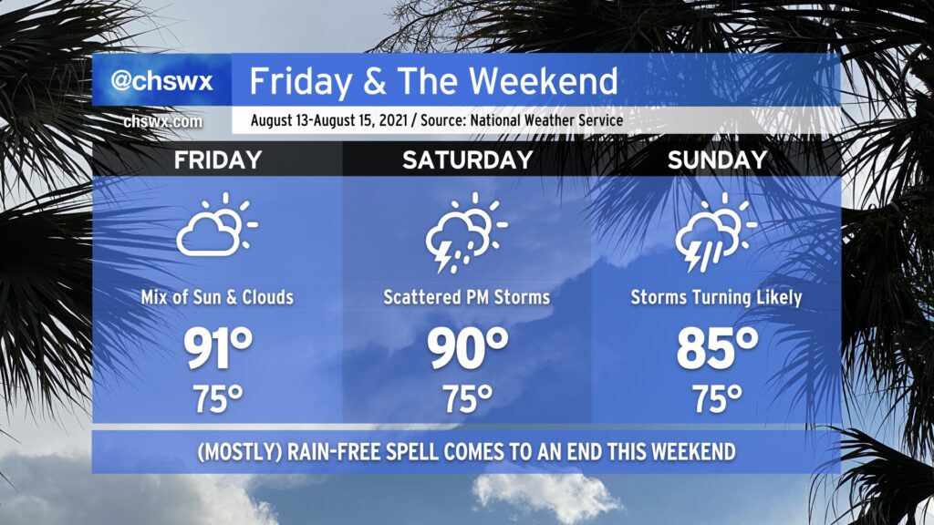
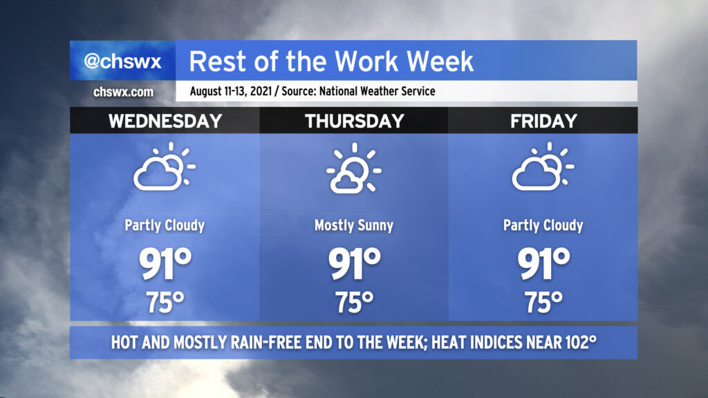
Friday gives us one more day of warm and mostly rain-free weather before the pattern turns back toward being more unsettled. Like today and the past few days, expect highs to top out a little over 90° in the afternoon, with heat indices in the low 100s. As always, a stray shower or thunderstorm can never be ruled out because, well, summer.
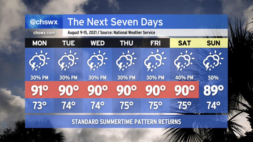
Our quieter weather pattern begins to shift back toward a more unsettled setup as the weekend wears on. Expect scattered thunderstorm coverage on Saturday, with highs topping out around 90° outside of those storms.
A front will sag southward into the area as we get into Sunday, stalling out over the Carolinas as Fred — forecast as a tropical storm — approaches the Florida panhandle (based on the current NHC forecast). The influx of tropical moisture with the nearby frontal boundary could spell some heavy rainfall at times across the area starting Sunday and into early next week. Stay tuned to forecast updates as the rain threat evolves.
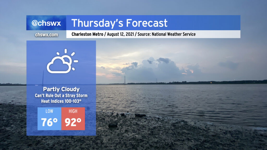
Thursday looks to be much the same as the previous few days: Temperatures in the low 90s, heat indices in the low 100s, and mostly rain-free conditions (with the disclaimer that a stray storm can never be ruled out this time of year — ask Goose Creek and Summerville all about that today). High pressure continues its firm grip on our weather both at the surface and aloft, and this looks to continue for a few more days before a front and enhanced tropical moisture moving into the area ahead of Tropical Storm Fred begin to increase rain chances to start next week.
While we can never totally rule out a popup shower or storm in mid-August, high pressure both at the surface and aloft should put the kibosh on precipitation as we get over the hump and finish out the work week. The forecast is pretty standard each day — highs in the low 90s, lows in the mid-70s (running closer to 80° near the coast, including in Downtown Charleston).
We certainly can use the drying time; so far we’ve had 18.04″ of rain this summer, a surplus of just over 3″ (3.01″, to be exact). That’s good for 24th on record to this point. The summer of 1973 continues to reign supreme in the rainfall department, though, with 35.33″ recorded at the airport from June 1 to August 10. (It could always be worse.)
As we get closer to the weekend, we’ll see rain chances begin to head back up as deeper tropical moisture looks to work back into the area.
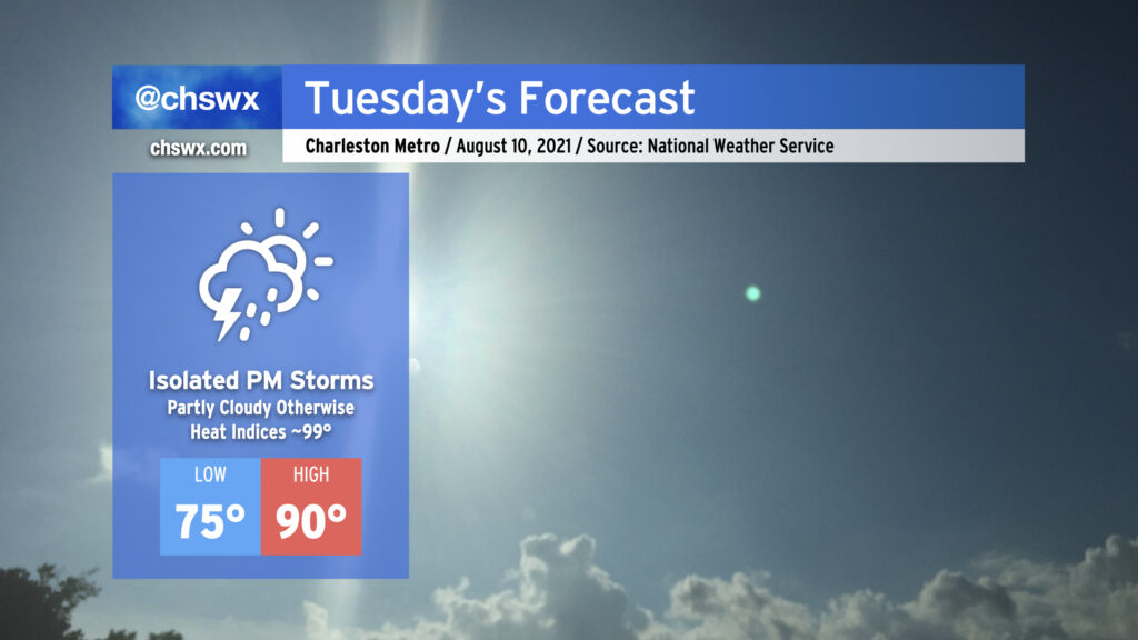
Tuesday promises another day of isolated showers and storms along and ahead of the seabreeze as highs top out right around 90°. Humidity will make it feel a little closer to 99-100° as the seabreeze moves past during the afternoon. Otherwise, there’s not too much to write home about as ridging of high pressure aloft and at the surface persists.
Mercifully, we are headed into a period of relatively normal weather for the next few days. Atlantic high pressure will build in at the surface, and subtropical ridging will move in aloft to click the pattern back into a more standard summertime configuration. Temperatures will top out in the low 90s each afternoon (though the humidity will make it feel closer to 100°), and the inland-advancing seabreeze will be the main focus for any shower or thunderstorm development. Not everyone will see rain every day, and it won’t rain all day at any one location. Just mind the afternoon heat and enjoy the relief if and when you get it.