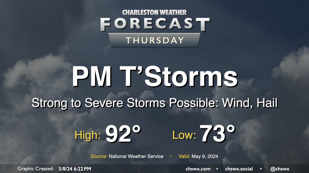
We get off to a warm start on Thursday — expect lows to only bottom out in the low to perhaps mid-70s with highs topping out in the low 90s and humidity making it feel closer to the upper 90s. The main weather story, though, will be the risk for some strong to severe thunderstorms moving through Thursday afternoon and into the evening. These could pack strong and potentially damaging wind gusts along with large hail. Exact timing is still unclear, but there is a risk these could coincide with the commute, so we’ll want to watch them closely. Stay close to reliable weather sources throughout the day for updates.
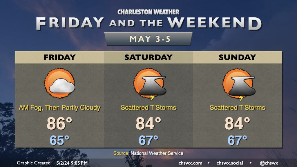
Get ready for another foggy start across much of the area Friday morning, as conditions appear favorable once again for some dense fog to develop and potentially have some commute impacts. Once again, if you’re encountering fog, slow down and use those low beams.
Once fog clears by mid-morning, expect generally partly cloudy skies with highs topping out once again in the mid-80s on Friday afternoon. A few inland spots could see a shower or storm, but the vast majority of us stay rain-free.
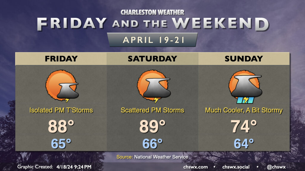
High pressure aloft will break down in time for Saturday, and some energy moving into the area will allow for isolated to scattered thunderstorms to break out particularly in the afternoon and early evening. It won’t rain all day in any one location, but having a backup indoor plan for your outdoor plans is a smart call. With the scattering of storms, expect highs to run a couple degrees cooler on Saturday, but still in the mid-80s. Sunday looks similar, with a slightly better chance of seeing some storms in the afternoon than on Saturday. Once again, expect lows in the mid-to-upper 60s to yield to mid-80s highs in the afternoon outside of thunderstorms.
From here, it turns hot…mid-90s may be in the cards by the middle of next week as we get a solid summer preview. (Whether that’s a good or bad thing is a thought exercise left to the reader.)
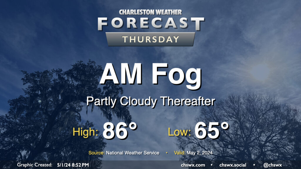
We’ll wake up to some fog in the area on Thursday morning, with some patches of dense fog not out of the question. This might have some commute impacts, to be ready to allow a little extra time to get where you are going tomorrow morning. Be sure to use low beams in fog, even if the sun is out — you want to be seen — but avoid the high beams as they may act to blind you.
Fog looks to scour out around 9-10am or so, and we should be in for a partly cloudy to mostly sunny day across the Lowcountry with temperatures rising to the mid-80s in the afternoon. Aside from the fog, there are no other weather concerns of note.
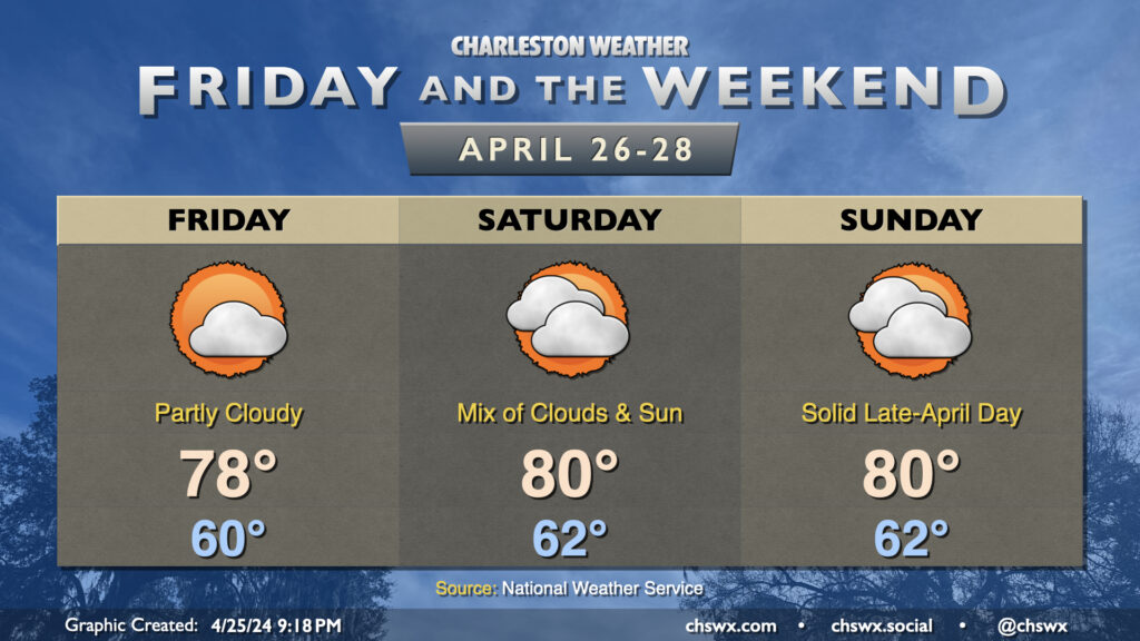
There’s not been too terribly much to write home about weather-wise this week, and that continues as we head into Friday and the weekend. Temperatures will remain generally within spitting distance of normal, and while we’ll have some cloud cover from time to time, plenty of sunshine will filter through as well as high pressure remains the dominant player in the forecast. Dewpoints will generally run in the mid-50s, yielding generally comfortable relative humidity values around 45-50% each afternoon.
Next week, expect temperatures to head several degrees above normal to close out April and welcome in May, with mid-to-upper 80s expected by mid-week. Shower chances look relatively low right now, even with a front trying to get nearby. So, if you’re looking for rain, it may be several more days!
This week’s stretch of quiet weather comes to an end as we head into the weekend courtesy of a cold front. We hit 90° for the first time at the airport today, and could get close again on Friday, though a surface trough and some energy aloft could combine for a few showers and thunderstorms during the afternoon. A strong storm can’t be ruled out, either, with gusty winds and some hail a possibility.
More vigorous energy moves into the area as the backdoor front gets closer on Saturday. It’ll be one more very summer-like day with highs approaching 90° in the afternoon, though scattered showers and thunderstorms will be a possibility beginning mid-afternoon on. Off and on showers and thunderstorms remain in the forecast for Sunday, though as the front sinks southward, we’ll turn much cooler — expect highs to run almost 15° cooler than they did on Saturday. Rain chances should peak later in the evening into the overnight before tapering Monday.
High Water-goers, be alert this weekend for quickly changing conditions and be ready to safe shelter if lightning approaches. We usually get kind of lucky with this event and the weather, and hopefully we can keep that stretch going. If not, though, be sure to keep this mantra in mind…”When thunder roars, go indoors!”
It was a very soggy Thursday with rainfall records falling across the area before the morning was out. Fortunately, the payoff is here, and it’ll be pretty great (albeit a bit windy to start). Friday will be very, very sunny, and a bit cooler than the previous couple days. We’ll start in the mid-50s, warming to the mid-70s in the afternoon. The only real fly in the ointment will be the wind, with gusts to 30 MPH possible at times as high pressure builds in.
Saturday will start even a little cooler, with lows around 50° expected before we warm to the mid-70s in the afternoon under predominantly sunny skies once again. It’ll still be a bit breezy during the day, with winds generally in the 10-15 MPH range, but it’ll be overall a great day to get outdoors. The 80s return on Sunday, and even warmer weather will follow next week.
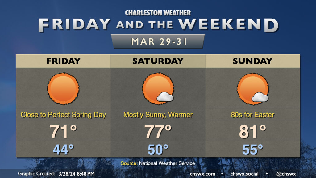
We’ve got no weather concerns for Good Friday and the Easter weekend. High pressure will be in control, and skies will be predominantly sunny for the next few days as a result. Temperatures will be on a warming trend throughout the period. We start Friday in the mid-40s and warm to the low 70s in the afternoon with full sunshine and low humidity. As high pressure at the surface shifts offshore a bit, temperatures will moderate. Expect Saturday to start around 50° and warm to the mid-to-upper 70s, while Easter Sunday will feature lows in the mid-50s and highs in the low 80s in the afternoon. All in all, a great weekend to get outside a bit (just mind the pollen!)
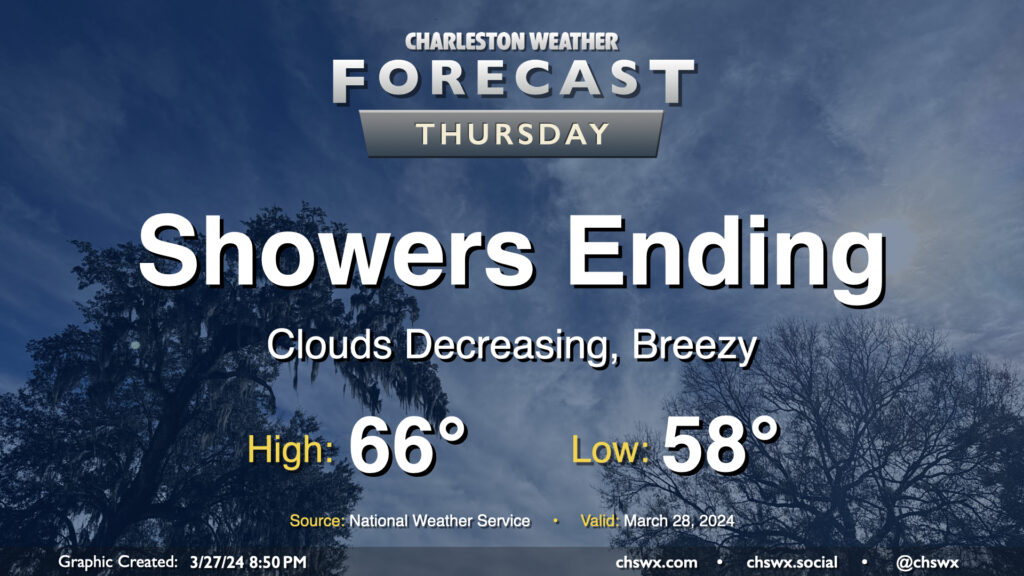
Showers will be coming to an end Thursday morning, yielding a quiet and increasingly warm period for Good Friday and Easter weekend. We should see the rain exit the area by midday, and from there, cloud cover will diminish. It’ll be a cool day in the wake of a cold front; expect highs to only top out in the mid-60s in the afternoon. The breeze will kick up at times as cooler air moves into the area behind the front as well, but it shouldn’t be too terribly gusty, either.
First off, you’ve probably noticed that I’ve not been posting the past few days. I’ve had a fairly significant death in my family that has kept me away from work and weather, and that will keep the posting and podcast schedule fairly bare at times for the next couple weeks. I’ll have more to say on that soon and how you can help if you are interested.
But first, we have a storm system arriving Friday that could pose a potentially significant flooding risk for downtown Charleston Friday night. Low pressure moving across the Gulf Coast states will drive perhaps a few rounds of heavy rain through the metro area starting Friday afternoon and well into the evening. This could coincide with high tide around 7:27pm to produce enough flooding to close roads downtown as well as in vulnerable locations in North Charleston and maybe even Summerville. 2″ or more of rain will be possible in many spots across the Tri-County. Be ready to curtail Friday night plans or find alternate routes in case widespread flooding develops.
Rain will continue into Saturday, though it’ll be more on and off. The heaviest stuff will have pivoted northward, but showers and maybe a thunderstorm should redevelop as a cold front pushes into the area during the afternoon. Severe weather is not expected, thankfully. Saturday’s the warmest day of the weekend with highs in the mid-70s, while post-front, we’ll see a solid 10° drop in high temperatures for Sunday. Clouds will be clearing, though, and we’ll be back in the 70s possibly as early as Monday.
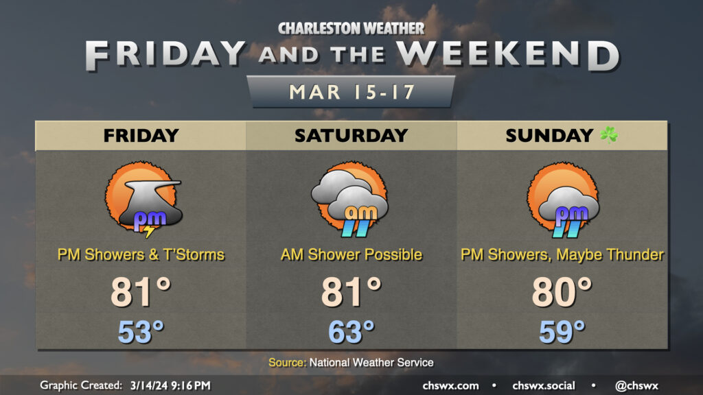
High pressure will lose its grip on the area for Friday and the weekend, allowing some periods of unsettled weather to move in — but don’t fret as we’ll have plenty of rain-free time as well. It’ll stay quite warm, too, with 80s expected each afternoon.
We’ll at least get Friday morning in rain-free ahead of a disturbance that’ll push a cold front into the area Friday afternoon and evening. Showers and a few thunderstorms will be possible by mid-afternoon leading into the commute, but not before we warm back into the 80s once again. A strong storm may not be totally out of the question west of 17-A, but high-res guidance generally shows storms in a weakening trend as they push eastward toward much cooler shelf waters.
Shower and thunderstorm chances persist overnight Friday into Saturday morning before what looks like a break in the action for much of the day. Temperatures start quite mild — think low to mid-60s — and warm back to the low 80s in the afternoon under a mix of sun and clouds. Shower chances should hold off Saturday night and into a good bit of Sunday before returning later in the afternoon and into the evening as another front approaches the area. This front shakes us out of our run of 80s and back below normal for Monday and Tuesday of next week.