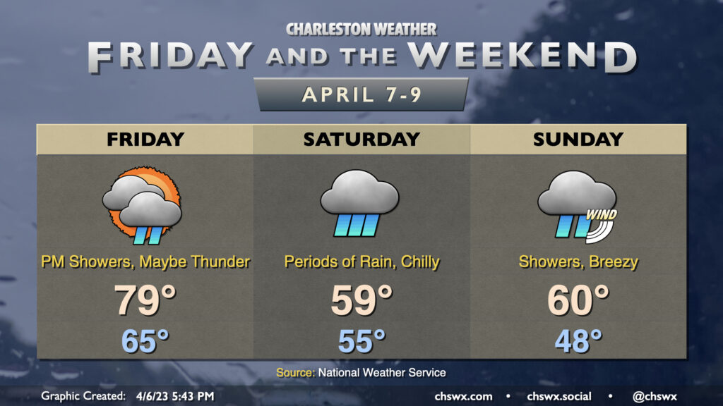
We’ve got one more warm day on Friday, but changes arrive in the evening as a cold front pushes southward across the area. Showers and maybe a thunderstorm will be possible ahead of the cold front (though no severe weather is expected) as said front moves by. Timing on the rain looks to be later in the afternoon into the evening hours. Highs will peak in the upper 70s and possibly touch 80° depending on when rain begins after starting in the mid-60s for one more day.
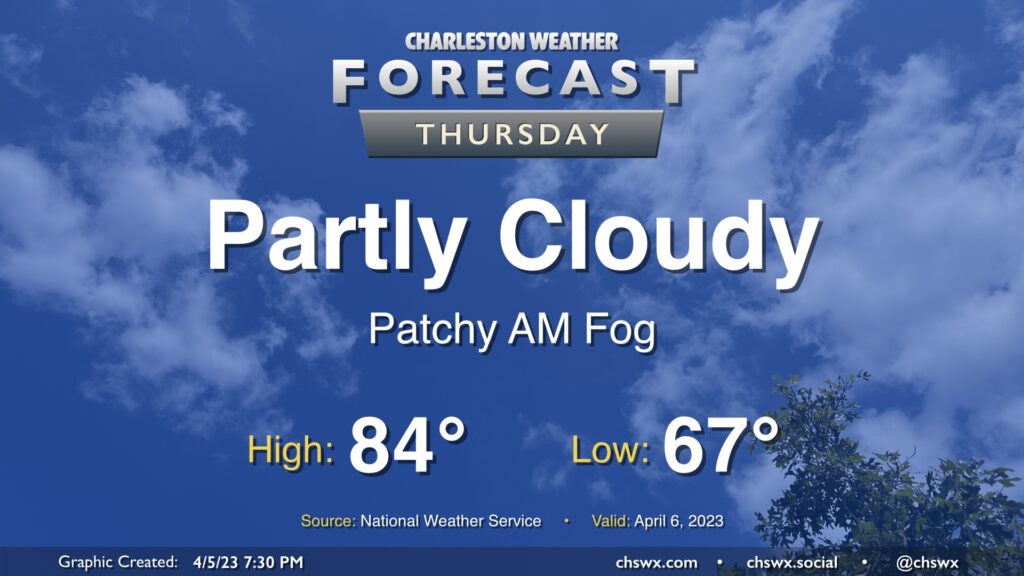
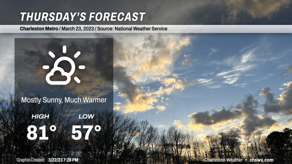
If you’re into highs in the 80s and rain-free weather, try to take advantage of Thursday because changes are in store heading into the weekend. We’ll start the day in the mid-60s, well above normal for this point in the year, before warming back into the mid-80s for the afternoon. (The record high of 90° set in 1967, thankfully, remains safe.)
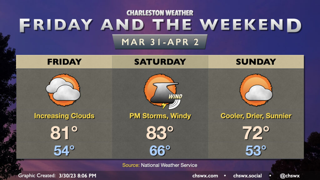
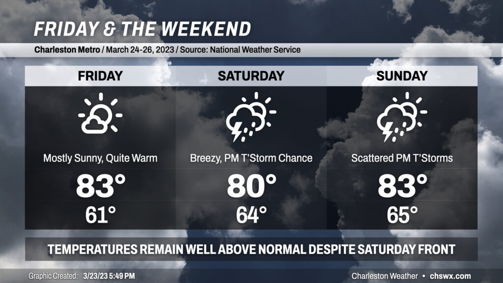
Our warming trend continues Friday ahead of a cold front that’ll arrive here Saturday evening with a few showers and storms out ahead of it. (We still look okay for the Bridge Run, though.)
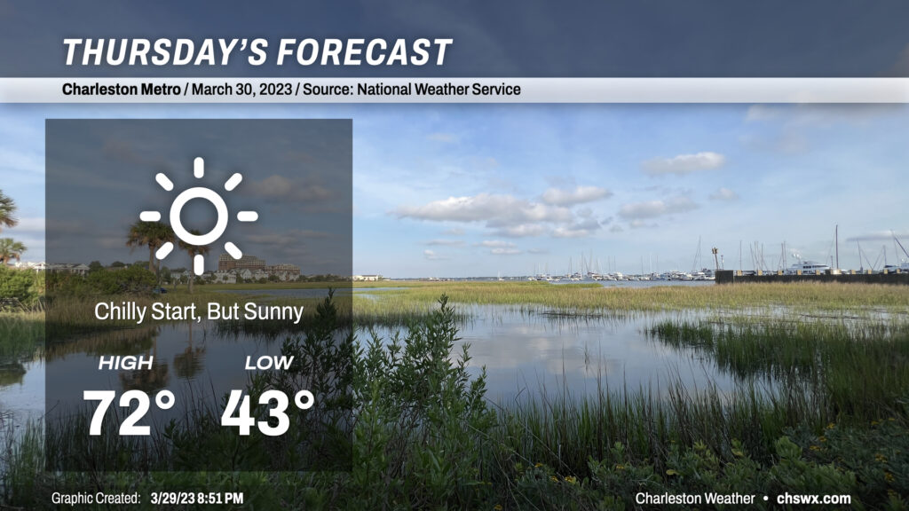
Calm winds and clear skies will allow temperatures to fall quite nicely tonight, with lows bottoming out in the low 40s across much of the metro area to start Thursday. (Thankfully, not low enough to deal with frost or freeze concerns.) Full sunshine will allow temperatures to warm nicely into the low 70s, making for what should be a rather pleasant day across the Lowcountry.
We stay quite warm for Friday into the weekend. Temperatures will remain in the low to mid 80s each afternoon despite a “cold” front projected to swing through later Saturday.
A warm front will lift north of the area tonight, clearing out the light rain and bringing back the 80s to the area for the next several days. We start Thursday in the mid-to-upper 50s, with temperatures warming into the low 80s away from the slightly cooler coastline in the afternoon under increasingly sunny skies. For reference, normal highs for this point in the year are in the low 70s, though we will remain well under the record high of 87° set in 1995. Winds out of the south and southwest will be a little breezy, which might add to some slight complications for any outdoor lunch plans. Other than that, though, a pretty decent late-March day.
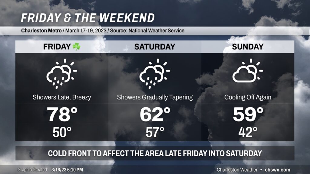
St. Patrick’s Day will be a warm one as southerly winds pick up ahead of a cold front. Gusts 20-30 MPH will be possible at times especially in the afternoon, which may have impacts on any outdoor activities. Expect highs almost 10° warmer than Thursday as they top out in the upper 70s. Increasing cloud cover will likely be the only thing keeping us from a run at 80°. We look to get much of the day in rain-free, though shower chances will be on the increase after sunset as the front draws closer. If your St. Patrick’s celebration extends into the night, you’ll want to keep rain gear handy.
Showers continue into Saturday morning as the front moves by. Scattered showers may continue to be an issue into Saturday evening, though I don’t see the day as a total rainout. Keep rain gear handy just in case, though. Highs look a lot different Saturday, with low 60s at best behind the front.
Skies go partly cloudy on Sunday with temperatures heading back below mid-March normals — struggling to 60° — as high pressure builds back into the area. We look to stay rain-free Sunday, so as long as you’ve got a jacket, the weekend isn’t a total wash.
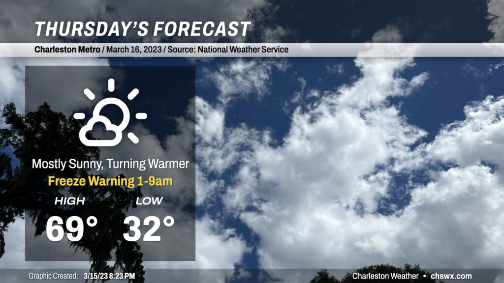
Be sure you’re protecting pets and plants tonight as another period of freezing temperatures will be possible across the metro away from the coast. Even where temperatures don’t dip below freezing, calm winds will make for much more favorable conditions for frost to develop. So, regardless of where you are, be sure to cover those sensitive plants and have loved ones in and warm.
Thereafter, a warming trend will commence as high pressure starts to slip offshore, turning winds a little more southerly. We’ll see highs top out very near 70° on what should prove to be a nice Thursday across the metro area. A few more clouds will begin to fill in later in the day ahead of a cold front.
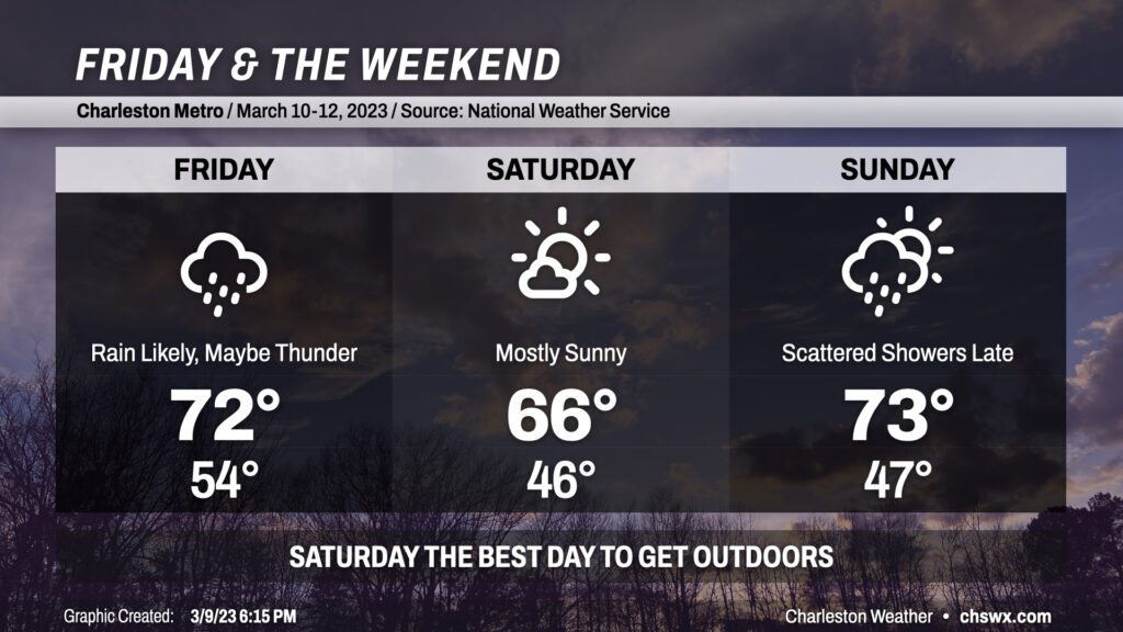
Clouds will be on the increase tonight as a storm system approaches the area from the west. We should remain rain-free through midnight before the atmosphere moistens sufficiently for showers to begin reaching the ground by tomorrow. Rain appears to be most likely from roughly mid-morning into early afternoon before cooler and drier air works into the area. Highs ahead of the front should peak in the low 70s despite the rain. A crack or two of thunder can’t be totally discounted, either.
Saturday is the pick day of the weekend for getting outside: it’ll run a little cooler and skies will be mostly sunny throughout the day. Expect highs to peak in the mid-60s after a start in the mid-40s. We should get Sunday morning in rain-free, especially near the coast, before precipitation chances head back up heading into the afternoon and evening hours. Highs should peak in the low 70s unless showers fire up sooner. The bulk of the rain looks to fall late Sunday into early Monday morning before a reasonably strong cold front punches through the area to send temperatures below normal for a few days next week. Stay tuned for timing changes on the rain as well as potential frost concerns for the middle of next week.
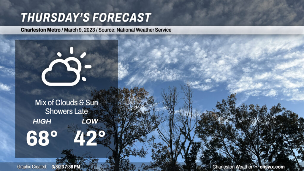
More seasonable weather for early March continues on Thursday with a few more clouds working their way into the area ahead of a storm system that’ll bring rain our way on Friday. We’ll start the day in the low-to-mid-40s before warming to the upper 60s in the afternoon. Rain chances should hold off until after midnight.