The week ahead starts off with the aftermath of a cold front, but that won’t be felt long as temperatures head right back toward, if not slightly above, mid-March norms as astronomical spring begins.
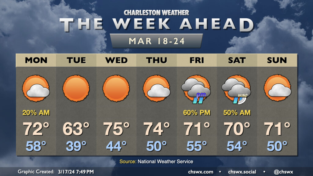
The week ahead will be largely marked by high pressure before the next storm system starts to affect the area just in time for St. Patrick’s weekend. (Sorry.)
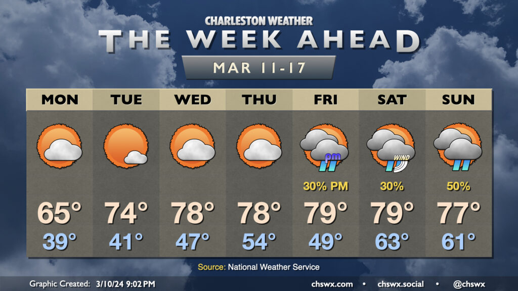
Well, it will certainly feel like climatological spring this week as we stay on the warm side of normal for early March with a couple storm systems dropping through at times. First, though, we’ll get off to another potentially foggy start Monday morning as lows dip to the mid-50s. Fog should dissipate by mid-morning, and we’re looking at another warm day in the mid-70s under a mix of sun and clouds as high pressure asserts itself a bit more.
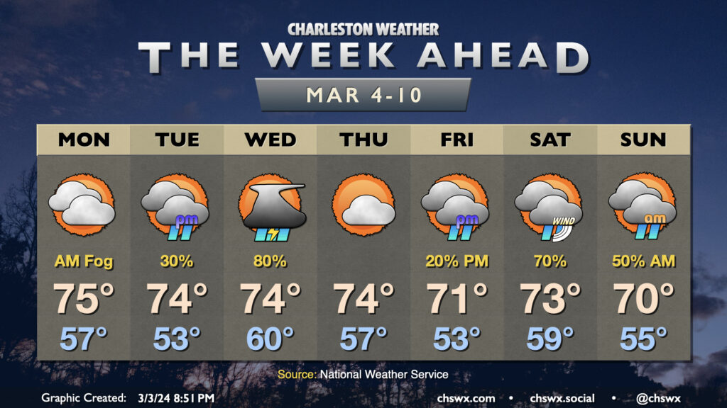
Sunday’s chill yields to a much warmer few days to start the new week and close out February. After a chilly start in the upper 30s, temperatures on Monday will rise into the low 70s, several degrees warmer than we reached on Sunday, thanks to plenty of sunshine and winds starting to go southerly as surface high pressure moves offshore. The warming trend continues for Tuesday and Wednesday, with lows in the low 50s on Tuesday yielding to highs in the mid-70s in the afternoon. Wednesday will start well above normal — think upper 50s — before temperatures make a run at 80° in the afternoon despite a mix of sun and clouds.
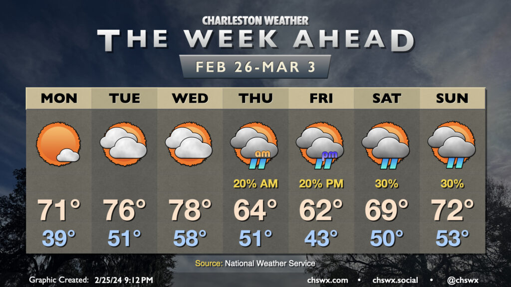
After a fairly dreary weekend (and a particularly chilly Sunday), the sun returns for a majority of the upcoming week (with a good-looking weekend on tap, too, for a change). We will stay on the chilly side for a couple more days, though, with lows in the mid-30s greeting us on Monday. Cloud cover will come and go throughout the day as a disturbance moves across the area, but it’ll be too dry at the surface for any rain. Still, there should be enough sun to get us to the low 60s Monday afternoon.
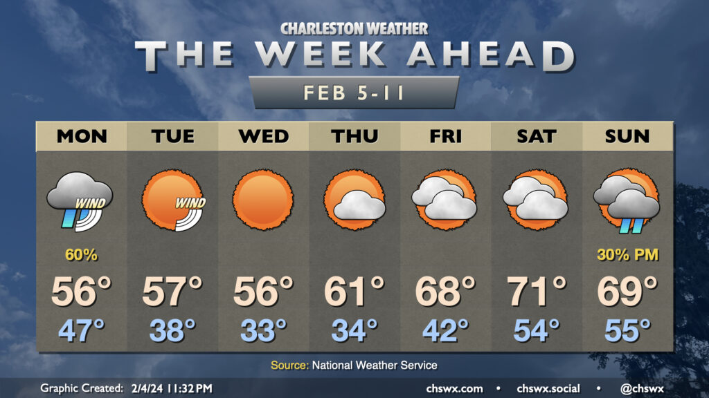
The upcoming week will get off to a fairly stormy start on Monday, but we’ll see things calm down and cool off a little bit for a few days before another storm system affects the area over the weekend.
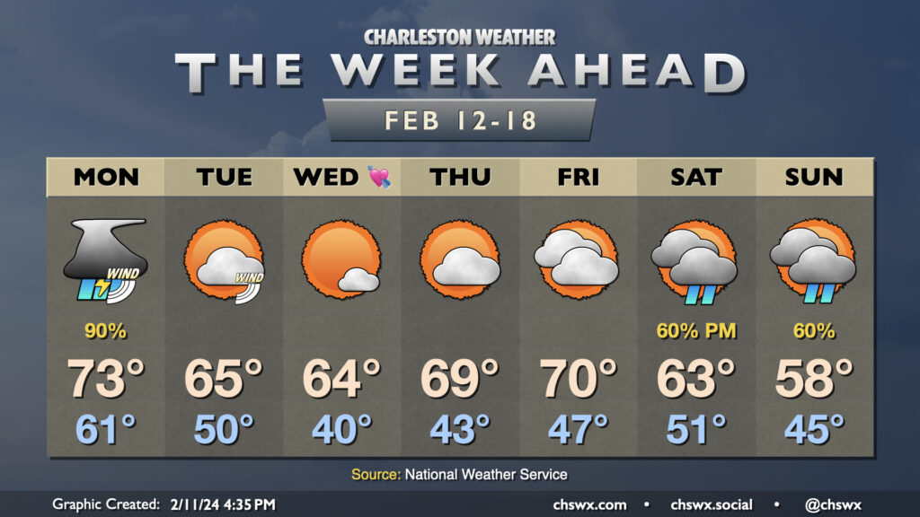
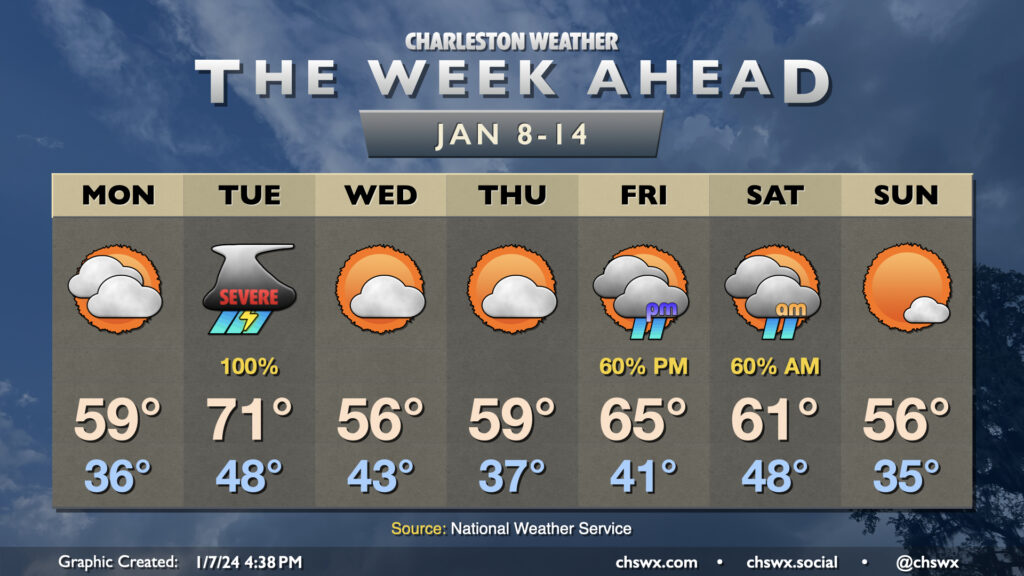
The first full week of February gets off to a stormy start as strong low pressure affects the area, particularly in the morning. We’re looking for the potential for some coastal flooding early in the day, and this combined with heavy rainfall could cause flooding problems across downtown Charleston, especially around high tide a little after 3:30am. A Coastal Flood Advisory is in effect from 2-6am for the salt water flooding threat; if that heavy rain does coincide, additional flood advisories for land-based areas would be needed. Rain does slowly taper off as Monday goes along, but we stay on the chilly side as breezy northeasterly winds blow in. This keeps highs capped to the mid-50s after an upper 40s start.
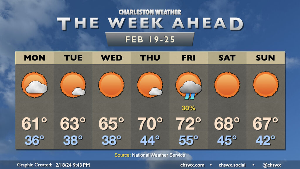
Temperatures will be much more seasonable this week as a trough re-establishes itself in the east over the next few days, though we will still run a couple degrees above late-January and early February normals (highs generally in the low 60s). Weather will be generally quiet this week as generally dry air and surface high pressure generally rules the roost. The main exception will be Wednesday as an upper low dips nearby, instigating surface low pressure across the Carolinas, but even then the risk for showers will be generally very limited given the dearth of moisture. Quiet weather resumes Thursday through Saturday before another storm system develops in the Gulf of Mexico and strafes the area to the south. Drier air will again limit our rainfall potential, but we will turn a little cooler heading into next week as another upper low lumbers through the area.
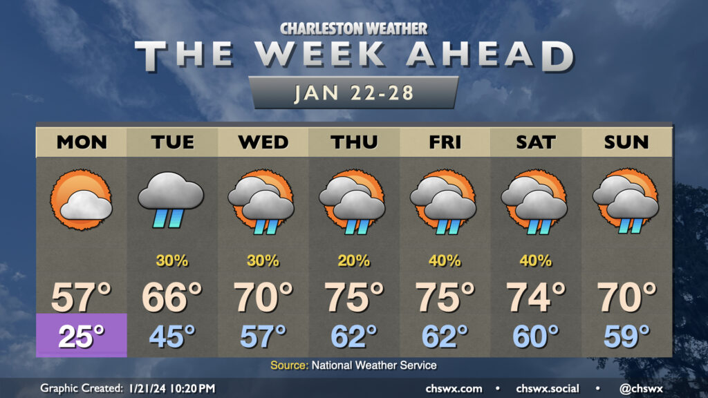
After a quite chilly weekend, we will be thawing out very quickly as we get into the new work week. Monday gets off to one more frigid start with lows in the mid-20s. From there, though, we start to see the arctic airmass begin to modify as a ridge builds aloft and surface high pressure shifts offshore. Monday’s high goes into the mid-50s, much warmer than we were at any point over the weekend. Then it gets downright spring-like: Tuesday warms into the mid-60s after a mid-40s start, and by Wednesday we’re in the 70s. Mid-70s take hold Thursday through Saturday ahead of a cold front, which should help to bring temperatures down a touch by Sunday.
The only fly in the ointment will be scattered shower chances beginning Tuesday and really lasting for the next few days as we sit between an upper trough to the west and ridging to the east. This will transport moisture and occasional upper-level disturbances into the area, and a surface trough along the coast will help act as a focal point for shower development. It won’t rain all the time or all day at any one spot, but all the same you’ll want rain gear handy just in case, especially heading into the weekend as the aforementioned front approaches.
The active weather pattern we’ve found ourselves in for the start of the year continues this week as we’ll see at least two storm systems visit the area, with quiet and generally cool weather days interspersed between them.
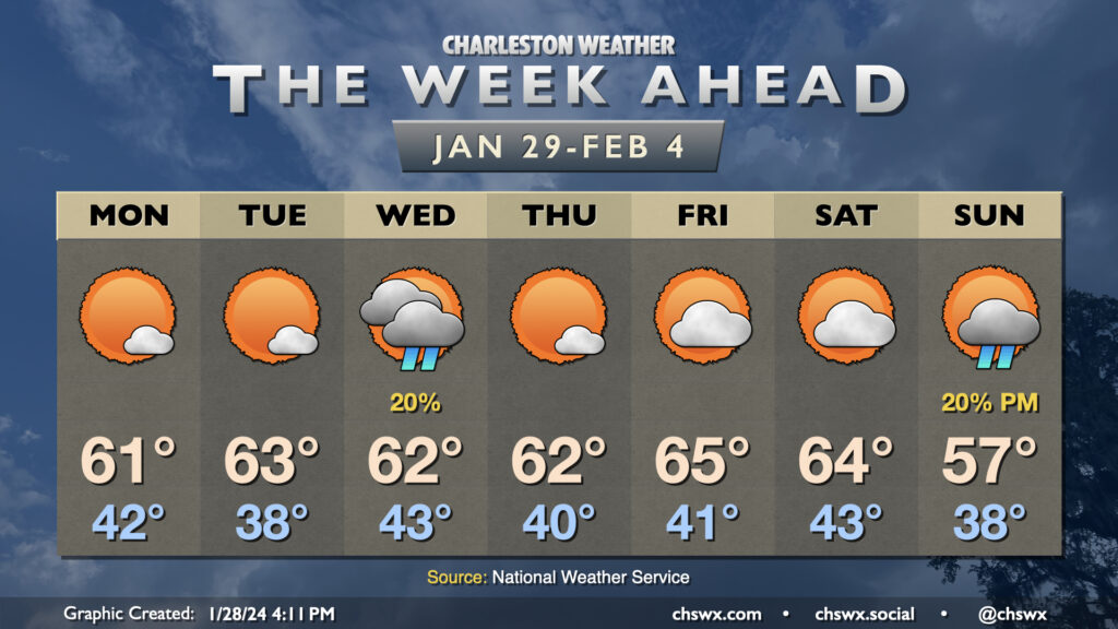
Monday will feature increasing clouds and a steady east to northeast breeze as high pressure wedges southward. We start the day in the mid-30s and warm to around 60° in the afternoon with clouds steadily increasing ahead of Tuesday’s storm system. Late Monday, a warm front will lift north of the area, which may bring some scattered showers along with it, but we should get much of the daylight hours, if not all of them, in rain-free.