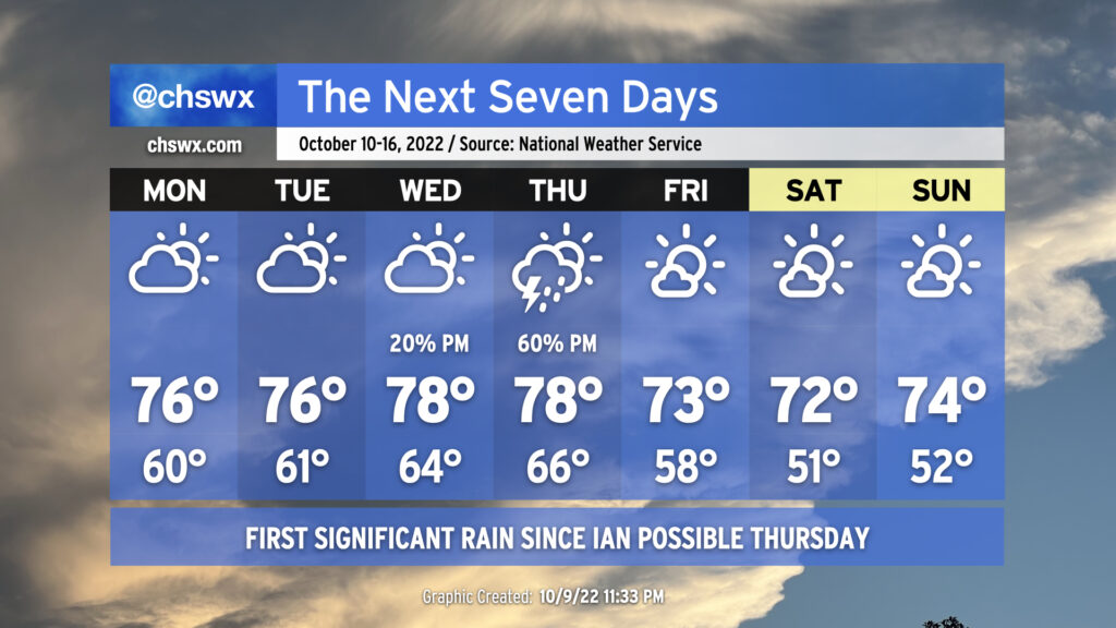
On balance, the week ahead will be primarily quiet weather-wise, with the exception of Thursday as a cold front presses through the area, bringing along some showers and thunderstorms. Highs through Thursday will remain a little below normal, generally running in the mid-to-upper 70s. Conversely, cloud cover and increased moisture will keep lows at or a little above normal through Thursday morning, with lows in the mid-60s expected Wednesday and Thursday right ahead of the front.
The weather on Thursday could bear watching for a few stronger storms depending on how much instability can develop. We’ll have good wind shear in place, but the instability — as is often the case as we head into the cool season — is going to be the main question mark. More likely, though, Thursday will represent the first significant rain for the area since Hurricane Ian, though amounts certainly won’t approach Ian-like numbers.
Once the front is through, we will see cloud cover decrease and temperatures once again head well below normal for Friday and the weekend, which is looking pretty good. Highs through this period will run in the low 70s, while lows will bottom out in the upper 50s Friday and the low 50s Saturday and Sunday, several degrees below normal for this point in the year.
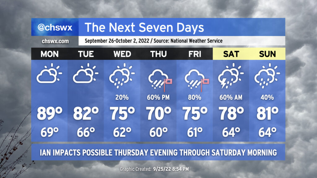
The week ahead will be punctuated by rough weather conditions courtesy of what is currently Tropical Storm Ian, which is finally beginning to intensify as I write this. It is expected to intensify into a major hurricane by as early as Tuesday morning, head over the western tip of Cuba, and then into the Gulf of Mexico where it moves up peninsular Florida’s Gulf Coast on the way to a landfall late Thursday/early Friday.
The week starts out innocuously enough; highs will head toward 90° on Monday ahead of a cold front which will push southeastward across the area throughout the day with maybe a shower, but the vast majority of us stay dry. Said front will knock Tuesday’s highs back to the low 80s under partly to mostly cloudy skies as high pressure wedges southward into the area. The front that got through Monday will then stall out and begin to retreat northwestward as a warm front on Wednesday as Ian approaches Florida. This could help spread a little shower activity in our direction, but otherwise expect mostly cloudy skies and significantly cooler temperatures — highs topping out only in the mid-70s underneath increasingly breezy northeasterly flow as the gradient between Ian to the south and high pressure centered to our north begins to tighten.
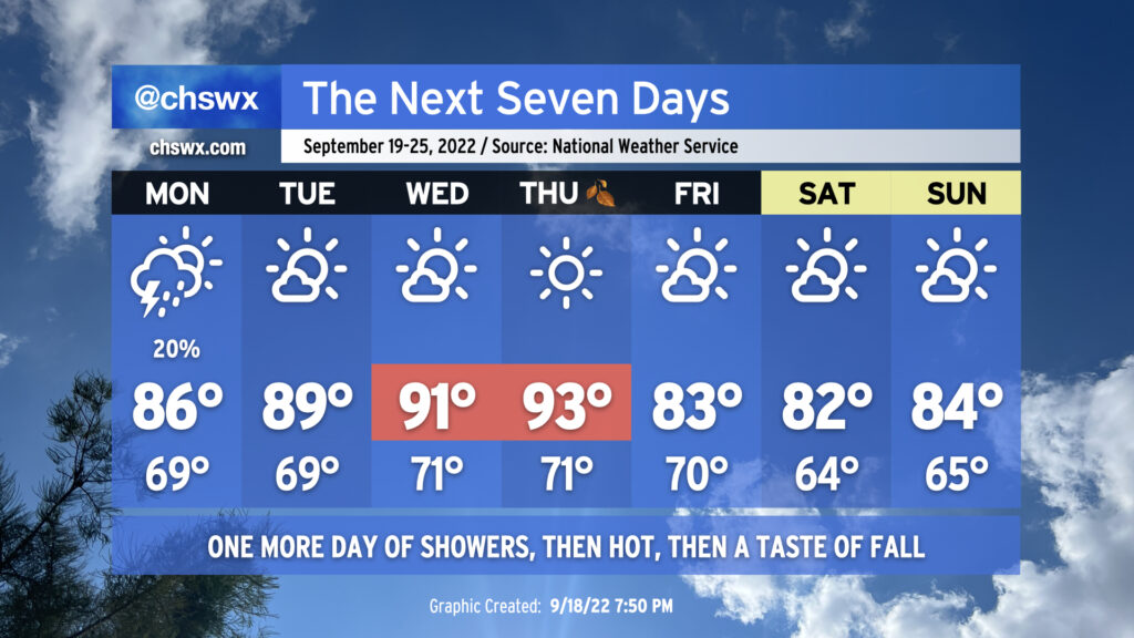
It’ll be a tale of two seasons this week — both figuratively and literally — as we reach the autumnal equinox on Thursday to usher in astronomical Fall. Summer’s gonna have one final parting shot, though, as a ridge expands across much of the southern US during the middle of the week.
We’ll still be dealing with a pesky coastal trough on Monday, which will toss some occasional showers and maybe a thunderstorm ashore. Temperatures will head up to the mid-80s away from the immediate coast; humidity will make it feel more like the low 90s. As the aforementioned ridge of high pressure builds in, though, the coastal trough will move away from the area, setting us up for a warm stretch mid-week. Tuesday’s highs will approach 90° as northerly to northwesterly flow aloft keeps cloud cover to a minimum. We get even hotter for Wednesday, with highs in the low 90s expected. Thursday’s going to be the hottest day of the set as compressional heating ahead of a cold front pushes temperatures close to the mid-90s — not quite meteorological conduct becoming of the first day of fall. Dry air in the area will limit cloud cover, much less any thunderstorm activity, so don’t count on that for any relief.
What we can count on, though, is the cold front to actually bring in a decent airmass change. Cooler and drier air will punch into the area overnight Thursday into Friday as the cold front gets through. We’ll start Friday on the warm side, but cool advection will kick in and keep temperatures from getting much warmer than the low 80s in the afternoon. The weekend is looking quite excellent, with a northeasterly breeze keeping temperatures a bit below normal for this point in the year and cloud cover to a minimum. We’ve just gotta get through this hot stretch first.
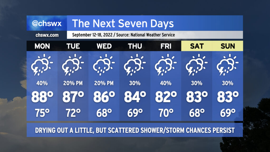
We’ll get a chance to dry out a little bit this week as a front swings through, ushering in some cooler and drier air around midweek. Rain chances don’t totally evaporate, though, and we’ll keep the risk for isolated to scattered storms especially as we approach the weekend. (At least it will feel quite a bit better than it has over the past few days!)
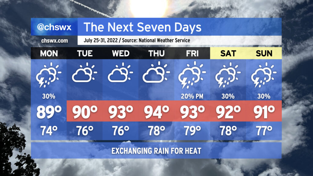
Monday will mark one more day with the unseasonably moist airmass that’s been torturing us for much of recent memory blanketing the area. There will be a slight chance for some morning rain, but much of that should be out of here by sunrise. We’ll wake up to lows in the mid-70s (higher near the coast and downtown) before highs reach the upper 80s under partly cloudy skies. A scattering of showers and thunderstorms will fire off in the afternoon and evening hours. Not everyone gets wet, but some heavy rain will be possible in the strongest storms.
Changes begin to arrive Tuesday as the front moves into the area. We should still see a fairly warm afternoon — highs mid-to-upper 80s are expected — but storm coverage should be a bit more sparse as some drier air begins to work into the area. The front gets through overnight Tuesday and we’ll start Wednesday perhaps in the upper 60s in some spots away from the coast. (Baby steps.) There will be a slight chance of showers coming ashore in the afternoon, but overall expect a partly cloudy day with less humidity than we’ve seen over the past few weeks.
High pressure wedging into the area will keep highs suppressed to the mid-80s Thursday and the low 80s for Friday and the weekend. There will be a chance for showers and maybe a thunderstorm depending on the track of a low that develops along the front, but certainly nothing like the sog-fest that we’ve seen lately.
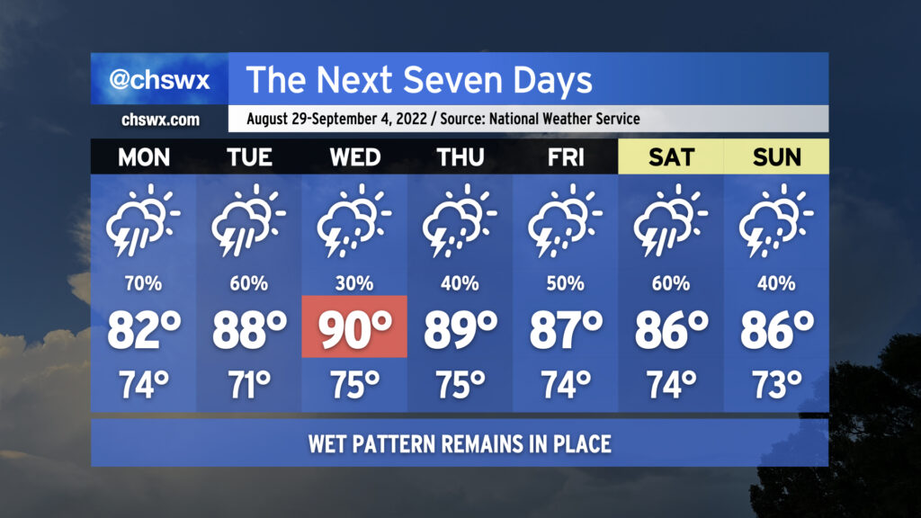
More wet weather is on the way as we remain in a rather unsettled pattern heading into the first days of September (and meteorological fall!)
We’ll likely start Monday with showers and maybe some thunderstorms in the metro area as offshore storms make a run to the coast. Be ready for a somewhat complicated commute due to rain. It’ll be worth watching downtown around high tide just before 10am, too, for the potential for heavy rain to combine with said tide to possibly produce some street flooding. Storms and their associated pockets of heavy rain will continue to spread inland throughout the day. Rain and cloud cover will keep temperatures suppressed to the low 80s.
We stay unsettled heading into Tuesday as a front moves toward the area. Thunderstorms will become likely once again in the afternoon, though temperatures will have a little more time to rebound into the upper 80s. Expect more scattered coverage Wednesday as a little drier air aloft moves in, which will allow temperatures to head into the low 90s in the afternoon ahead of the front. The front moves by Thursday and stalls out to the south, which will help keep moisture in place and the risk for showers and thunderstorms in the forecast as we head into the Labor Day weekend. As is customary for late summer, there will not be any day that’s a total washout — just have backup plans for any outdoorsy things you might have going on.
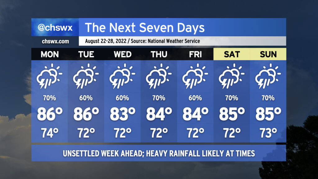
We’ve got an on-again, off-again soggy kind of week in store as an unsettled pattern characterized by a persistent mid-level trough over the eastern US stays firmly in place. Before it’s over, many spots could see another 2-3″+ of rain on average, with locally heavier amounts depending on where downpours set up. The greatest risk of thunderstorms will be the afternoon and evening hours each day, but the atmosphere will be such that a shower or storm could happen at pretty much any time. As the week goes by and soils get soggier, we will see an uptick in the flood threat as well.
Suffice to say, this is one of those weeks where we could see another Downtown flooding event or two. It’s almost impossible to pinpoint what day this could happen, as these events are often driven by smaller processes that are impossible to model accurately with any sort of lead time. Keep a close ear to forecast updates, and monitor for possible Flood Advisories from the National Weather Service.
The one upside to rain and cloud cover? Temperatures will be held into the mid-80s for much of the week, though any sunshine that breaks out immediately after a storm will make things feel steamy.
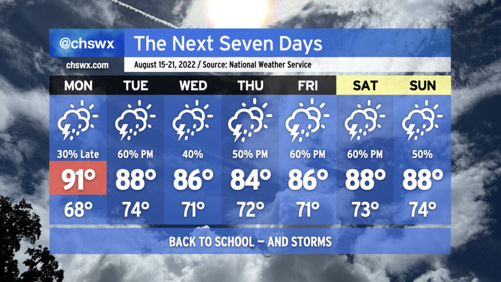
After a weekend in which we felt the lowest dewpoints in almost two months, more moisture will begin to work back into the area as another front drives into the area and stalls out, leading to an unsettled back-to-school week across the Lowcountry.
We’ve got one more cool start to the day on Monday as lows bottom out in the mid-to-upper 60s away from the coast, but that’ll quickly give way to low 90s in the afternoon. Much of the day remains dry, but we’ll want to keep an eye on what takes place to our northwest as the aforementioned front, along with some upper-level help, drives a cluster of showers and thunderstorms through the western Carolinas during the day. It’s possible that it could hold together to bring us some showers and maybe a thunderstorm or two in the late evening as it migrates southeastward. A few storms could be severe especially along and west of I-95, too. It’s not a slam dunk, but certainly worth watching.
Rain becomes more likely heading into Tuesday as the front arrives and stalls out. A wave of low pressure along the front should enhance shower and thunderstorm chances for the afternoon. There will be plenty of moisture to wring out a fair bit of rain out of the heaviest storms, so we’ll be watching closely for the potential for localized flooding concerns. This setup continues through the rest of the week as the front will continue to meander around the area, occasionally with a wave of low pressure traversing it to help enhance those rain chances a bit more at times. (Stay tuned for day-to-day adjustments to these — stalled fronts are fickle beasts.) Temperatures will generally run in the mid-to-upper 80s in the afternoons, tempered by rain chances and cloud cover.
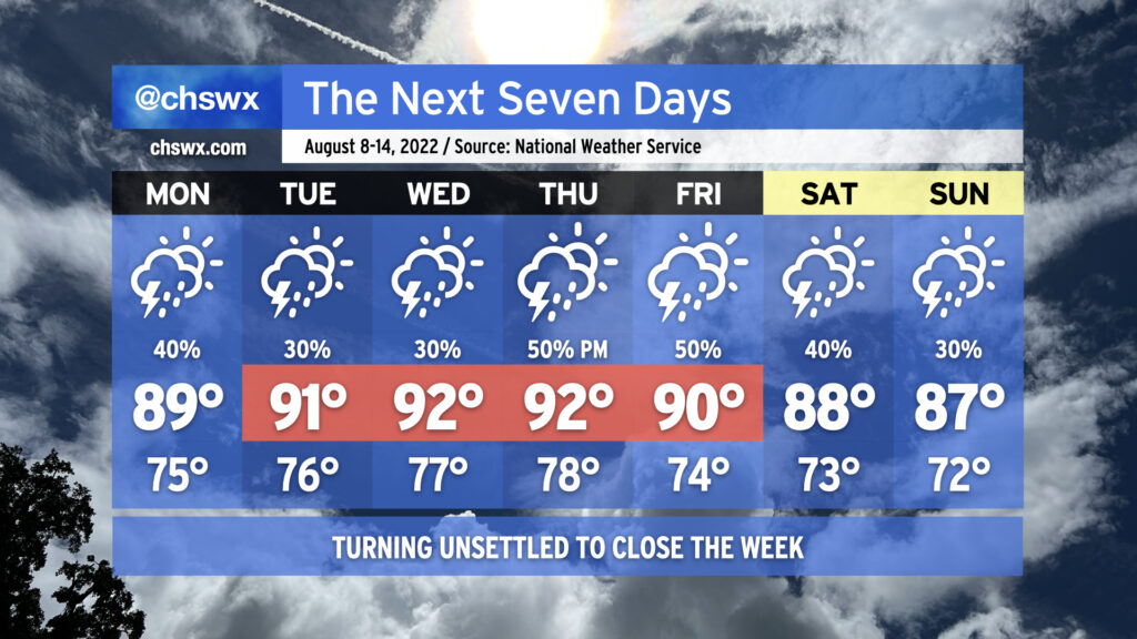
Standard warm & muggy August weather will continue this week with an uptick in shower and thunderstorm coverage coming thanks to a stalling cold front.
Monday looks to remain somewhat on the unsettled side as a mid-level feature known as a TUTT (tropical upper-tropospheric trough — say that five times fast!) continues to whirl into the area. This should help kick off some isolated to scattered showers and storms to start the day near the coast. Eventually, we should see the seabreeze begin to push inland, and along with it, more isolated to scattered showers and storms, with rain chances moving westward with time. Temperatures will generally top out in the upper 80s to around 90° in the afternoon; heat indices will approach 100°.
Expect additional seabreeze-driven showers and storms Tuesday and Wednesday, with highs topping out in the low 90s each afternoon. Storm coverage ratchets up a little beginning Thursday afternoon as a front approaches the area; scattered to numerous storms are possible Friday with the aforementioned cold front approaching the area. We’ll stay unsettled into the weekend, with high temperatures trending down a little further into the 80s in the afternoons thanks to onshore flow and scattered storms.
The severe weather risk this week is low, but an isolated strong or severe storm can never be totally ruled out at this point in the year. Heavy rain and lightning will be the main concerns from thunderstorms, and slow storm motions at times may produce areas of isolated flooding. All in all, nothing terribly out of the ordinary for early-to-mid-August — just make sure the rain gear is close and that your outdoor activities have indoor backup plans.
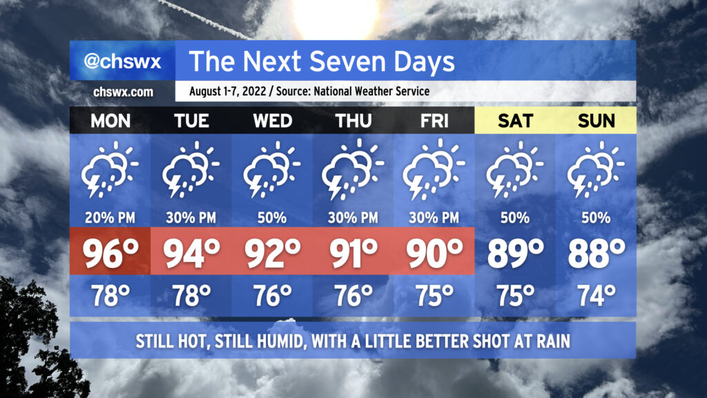
We say goodbye to July and hello to August with appropriately hot and humid conditions for this point in the summer, though we’ll see air temperatures fall a bit as the week progresses, which will have a little downward pressure on heat indices primarily as we get into the weekend. We have some rain chances in there as well, particularly mid-week.
Monday will be the hottest day air temperature-wise as highs look to peak in the mid-90s, though some drier air aloft will mix down and bring dewpoints to around 70° in the metro area, keeping heat indices in check to around 100-103°. An afternoon shower or storm can’t be ruled out, but coverage should be sparse.
Tuesday could see a little more convective coverage as high pressure aloft begins to shunt southward a little, while Wednesday should be even a little more active as a trough approaches from the southwest and return flow from the Gulf establishes itself nicely with Atlantic high pressure retrograding eastward. Thursday and Friday feature more typical afternoon thunderstorm chances. Highs in this period will steadily head down, ranging from 94° on Tuesday to 90° on Friday. However, the infusion of humidity will keep heat indices in the low 100s through Thursday despite the lowering air temperatures.
Temperatures will continue to fall into the weekend, with highs stopping short of 90° expected Saturday and Sunday thanks to a little more in the way of onshore flow as Atlantic high pressure shifts a little more northward. This could also keep rain chances a touch higher, as well, but no washout is currently in the cards for the weekend. Overall, pretty standard early-August fare for the Charleston metro area.
The good news is that there are some predominantly rain-free days in the forecast this week. (Imagine writing that three weeks ago!) The less-than-good news is that temperatures will head back up, with heat indices perhaps approaching 110° later this week before a slightly more unsettled pattern returns for the weekend.